ICSE Solutions for Class 7 Geography Voyage – Greenhouse Effect and Global Warming
ICSE SolutionsSelina ICSE SolutionsML Aggarwal Solutions
APlusTopper.com provides step by step solutions for ICSE Solutions for Class 7 Geography Voyage. You can download the Voyage Geography ICSE Solutions for Class 7 with Free PDF download option. Geography Voyage for Class 7 ICSE Solutions all questions are solved and explained by expert teachers as per ICSE board guidelines.
ICSE Solutions Class 7 Geography History & CivicsMathsPhysicsChemistryBiology
DISCUSS
Collect rainfall data from the website of Indian Meteorological Department (IMD) for Mumbai, Chennai, Delhi and Kolkata and discuss how rainfall patterns have changed in the last 5 years.
Answer:
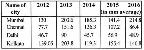
Mumbai receives maximum rainfall in 2016 and minimum rainfall in 2012.
Chennai receives maximum rainfall in 2013 and minimum rainfall in 2012.
Delhi receives maximum rainfall in 2013 and minimum rainfall in 2014.
Kolkata receives maximum rainfall in 2013 and minimum rainfall in 2014.
VALUES AND LIFE SKILLS :
We need to understand that global warming, climate change, acid rain and ozone depletion are all happening because of our dependence on fossil fuels and CFC-based technologies. Therefore, the need of the hour is to reduce
our dependence on them.
What can you do in this regard ?
Answer:
The ways to reduce our dependency on them are :
- By using materials such as bamboo, recycled metal and organic paints in construction of buildings.
- By using solar energy to heat and light homes and offices.
- By using clean fuel like CNG and unleaded petrol to run vehicles.
- By making changes in everyday practices such as
(a) choosing to travel in public vehicles, biking, walking or using a car pool.
(b) buying energy efficient household appliances.
(c) replacing light bulbs with CFL bulbs.
EXERCISES
A. Fill in the blanks.
1. Carbon dioxide and methane, nitrous oxide, water vapour and CFCs are examples of greenhouse gases.
2. Global Warming is a major cause of climate change.
3. The increase in earth’s temperature is called global warming.
4. The layer of atmosphere where ozone is found is called stratosphere.
5. The ozone layer protects us from the ultraviolet rays of the sun.
B. Write True or False.
1. Aeroplanes flying in the sky cause global warming.
Answer. True.
2. Forest fires do not cause global warming.
Answer. False.
Correct : Forest fires do cause global warming.
3. Ozone is found in the troposphere.
Answer. False.
Correct : Ozone is found in the stratosphere.
4. The ozone layer is harmful for humans and animals.
Answer. False.
Correct : The ozone layer is not harmful for humans and animals.
5. CFCs and BFCs protect the ozone layer.
Answer. False.
Correct : CFCs and BFCs deplete the ozone layer.
C. Choose the correct option.
Question 1.
Oxygen/Carbon dioxide is a greenhouse gas.
Answer:
Carbon dioxide is a greenhouse gas.
Question 2.
Use of fossil fuels/hydroelectricity causes global warming.
Answer:
Use of fossil fuels causes global warming.
Question 3.
Cattle release methane / CFCs.
Answer:
Cattle release methane.
Question 4.
Global warming will reduce/increase climate change.
Answer:
Global warming will increase climate change.
Question 5.
The ozone layer is found between 20 and 40/40 and 60 km above the earth’s surface.
Answer:
The ozone layer is found between 20 and 40 and above the earth’s surface.
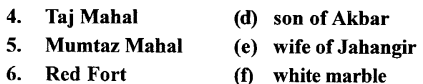
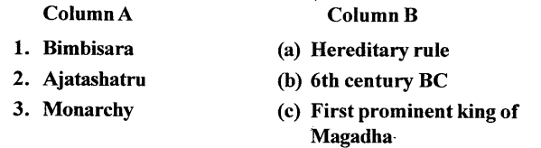
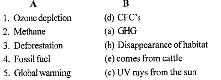
D. Match the following
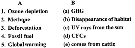
Answer:
E. Answer the following questions in brief
Question 1.
Why do we call carbon dioxide a greenhouse gas?
Answer:
Carbon dioxide is called greenhouse gas because it absorbs
Infrared radiations. A greenhouse gas is a gas in an atmosphere that absorbs and emits radiation within the thermal infrared range.
Question 2.
Name two more greenhouse gases.
Answer:
Methane and water vapour are other greenhouse gases.
Question 3.
How will countries like Bangladesh and Thailand be affected by global warming?
Answer:
Climate change will cause melting of polar ice caps with huge chunks of icebergs several kilometres across breaking off from the mainland. This is already taking place around the Arctic and in Antarctica. The result will be an increase in the volume of ocean waters. Countries like Bangladesh, Thailand and Malaysia and the Southeastern parts of USA like the States of Florida and Louisiana would be swamped by flood water along its shores.
Question 4.
What is responsible for causing a hole in the ozone layer?
Answer:
The release of large amount of CFCs or chlorofluorocarbons and BFCs or bromofluorocarbons by industries are responsible for the formation of holes in the ozone layer.
Question 5.
Name some diseases that are caused due to exposure to ultraviolet rays of the sun.
Answer:
Exposure to UV rays can cause sunburn, cataract, hair loss, skin cancer and birth deformities.
F. Answer the following questions in one or two paragraphs
Question 1.
How is the greenhouse effect created?
Answer:
The ‘greenhouse effect’ takes place when the ‘sun’s rays heat the earth. This heat is absorbed by the surface of the earth and some of it is radiated back into the atmosphere. However, a part of this heat is trapped in the atmosphere by gases such as water vapour, carbon dioxide and methane while the rest escapes into space. These gases let in light from the sun but prevent the heat from escaping like the glass walls of a greenhouse. They also act like a mirror and reflect back to the earth some of the trapped heat energy. The more greenhouse gases (GHGs) are present in the atmosphere, the more heat is trapped, subsequently making the earth warmer.
Question 2.
State three causes that have led to an increase in greenhouse gases in the atmosphere.
Answer:
The causes that have led to the increase in greenhouse gases (GHGs) are:
- Increase in industries
- Increase in deforestation
- Increase in atmospheric pollution due to emissions from chimneys of factories
- Increase in natural disasters like floods, volcanic eruptions and earthquakes that release large amounts of smoke, dust and gases into the atmosphere
- Increase in the methane content of the atmosphere because of large-scale cattle rearing, since cattle release methane
- Expansion of cies and towns
Question 3.
What do you understand by the term ‘global warming’?
Answer:
The greenhouse gases in the atmosphere trap a part of the heat radiated back by the earth, increasing its temperature. The increase in the earth’s temperature is called global warming.
Question 4.
State some anthropogenic (man-made) causes of global warming.
Answer:
Man-made causes of global warming ‘include burning of fossil fuels, cutting of forests, using refrigerators, air conditioners, aerosols, factories belching smoke, increase in methane content of the atmosphere because of large-scale cattle rearing, expansion of cities and towns.
Question 5.
Global warming does not augur well for our planet earth. State at least three reasons to support this statement.
Answer:
Global warming is not good for our planet as
(a) It will worsen climate changes leading to food shortages.
(b) Many forms of wildlife are now’ at risk and since climate change and deforestation are causing disappearance of their habitat.
(c) Climate change will cause melting of polar caps resulting in the increase in the volume of ocean waters.
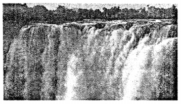
G. Picture study.
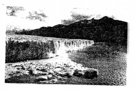
Question 1.
Which region of the world is seen in the picture?
Answer:
Antarctica and Arctic Poles.
Question 2.
How is it going to be affected by global warming?
Answer:
Global warming causes melting of polar ice-caps with huge chunks of icebergs several kilometres across breaking off from the mainland resulting in increase in volume of ocean waters. The increase in the volume of ocean waters will result in rising of sea levels. Countries like Bangladesh, Thailand and Malaysia and the Southeastern parts of USA like the States of Florida and Louisiana would be swamped by flood water along their shores.
LETS DO SOMETHING
Question 1.
Imagine that you are an active member of the Greenpeace. Write a two-page appeal addressed to the Prime Minister of India stating why you think that increasing number of vehicles on roads will be disastrous to the nation in the long run.
Answer:
August 25, 2017,
Mr. Narendra Modi,
Prime Minister of India
Dear Prime Minister Modi,
It is with great optimism and hope that we are following news about the meeting you will have with U.S. President Trump, at this critical time in our planet’s future. 2017 is the year for making decisive commitments towards tackling climate change together. As the elected leader of the world’s largest democracy, and a country with much to lose from run away climate change, the hopes of 1.3 billion Indian citizens rest on you. Along with them, and the millions of people worldwide who will inevitably be affected by decisions made this year, we hope you will successfully push the United States, and the developed world, towards an ambitious and equitable global agreement to rein in climate change.
We congratulate you on setting new and ambitious renewable energy targets, and urge a focus on decentralized renewable energy as the fastest, most cost-effective way to tackle India’s energy poverty challenge. At the same time, we believe that continued growth in coal power is not in the interests of common Indians as it imposes a significantly higher cost on people’s health, livelihood of communities and the environment, and will prove far more expensive than renewable energy. We hope you will secure much-needed support from global partners, civil society and investors – including the United States administration – to realize these renewable energy goals.
Being the member of the Greenpeace, I would like to bring in your kind notice that I found that the number of vehicles has increased considerably in India in the past five years, which is one of the sources of pollution. In the recently released World Health Organization (WHO) report on pollution, the situation of the city is not so encouraging in terms of pollution in the air.
Due to increase in number of vehicles over the years, the city roads witness frequent traffic congestions, but above all, the vehicles emitting pollutants are affecting environment badly. The recently-released WHO report shows that India has 2.5 microns of diameter (PM2.5) concentration of 68 micrograms particulate matter per meter cube. However, the WHO guideline values for particulate matter is 10 microgram per meter cube for PM2.5.
“The air pollution consists of many pollutants, among other particulate matter. These particles are able to penetrate deeply into the respiratory tract and therefore constitute a risk for health by increasing mortality from respiratory infections and diseases, lung cancer, and selected cardiovascular diseases,” says the WHO report.
New patients with respiratory problems are constantly being reported in hospitals. Recently, the many big cities are witnessing a flow of traffic on city roads consisting high end cars too. Moreover, as far as public transport is concerned, the government-owned low floor buses could be seen plying on the road emitting black smoke causing problems for pedestrians, bikers and other roadside vendors. Mr. Avinash Chowdhry senior member of Greenpeace took out a rally of school children at Statue
Circle (Mumbai) on the eve of World Environment Day said, “Men’s health is determined by his environment. He is greatest enemy of his own health. Environmental pollution is one of the reasons of cardiovascular diseases, hypertension and diabetes.”
Collaboration between the government and civil society is essential to secure a bright future for India and the planet. Greenpeace looks forward to working with the Indian government on our common objective of ensuring clean, affordable renewable energy for all.
Sincerely,
VeenuGopal,
Interim Executive Director, Greenpeace
Question 2.
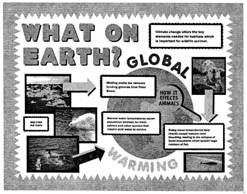
Make a collage using pictures or a chart to show the various causes and consequences of global warming.
Answer:
You can take idea from the picture given below and can make a collage of your own.