ICSE Solutions for Class 6 Geography Voyage – Major Landforms of the Earth
ICSE SolutionsSelina ICSE SolutionsML Aggarwal Solutions
APlusTopper.com provides step by step solutions for ICSE Solutions for Class 6 Geography Voyage. You can download the Voyage Geography ICSE Solutions for Class 6 with Free PDF download option. Geography Voyage for Class 6 ICSE Solutions all questions are solved and explained by expert teachers as per ICSE board guidelines.
ICSE Solutions Class 6 GeographyHistory & CivicsBiologyChemistryPhysicsMaths
POINTS TO REMEMBER
- Nearly 29 per cent of earth’s surface is land.
- Land features on the surface of the earth are different in different places. These features are called landforms. The major landforms include mountains, plateaux, valleys and plains.
- There are three main types of mountains—fold mountains, volcanic mountains and block mountains.
- There are two types of fold mountains—old and young.
- Plateaux are also called plains-in-the air or tablelands.
- Plains are flat lowlands that are mostly built by the alluvium deposited by rivers.
IMPORTANT TERMS
Fold mountains: Mountains that are formed when horizontal layers of the earth’s crust are folded by compression.
Landforms: Features of the land surface.
Discuss
Formation of landforms is a continuous process. Discuss the different ways in which landforms are changing around the world.
Answer:
The earth’s surface is constantly changing. These changes mostly occur in very minute ways which over time accumulates to create the earth’s physical features. Whereas some of these changes take thousands of years but surely they are occuring. We look around us that a mountain, river, plateau, valleys, rqck boulders etc. these all didn’t just disappear suddenly rather most of them had a building process.
There are basically two types of changes that occur on the earth’s surface.
- Slow change
- Fast change.
Fast change occur through the actions of earthquakes, volcanoes, landslides etc. While slow change takes time and has a process.
VALUES AND LIFE SKILLS
We constantly impact landforms around us by our actions such has mining, building roads, dams, etc. We should, therefore, try to minimize such activities that have an adverse impact on landforms around us.
How can you help to preserve the landforms around you?
Answer:
We can preserve the landforms around us by adopting following methods, and they are :
- By Planting More Trees and Not cutting them.
- By Properly Disposing the Industrial waste.
- By Preserving greenery surrounding, National Parks and Wildlife Sancturies.
- Avoid de-vegetating the landforms and its Vicinity, if that’s it’s natural condition.
- Replicate Natural landscapes, patterns and processes.
EXERCISES
A. Match the columns
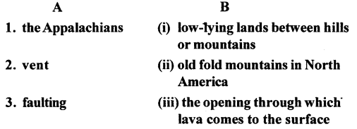

Answer:
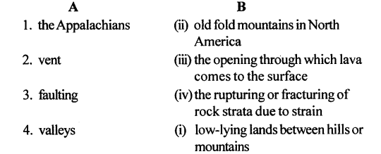
B. With the help of your atlas identify and mark the following in an outline map of the world.
Question 1.
An old fold mountain range in India.
Answer:
Aravallis
Question 2.
A block mountain in Europe
Answer:
The Black Forest of Europe.
Question 3.
A storehouse of mineral wealth in eastern india.
Answer:
The Chota Nagpur Plateau.
Question 4.
A rift valley in Egypt
Answer:
NileValley in Egypt.
C. Answer the following questions in brief
Question 1.
What are fold mountains? With the help of a neat-sketch, briefly explain their formation.
Answer:
The mountains that are formed when the layers of the earth’s crust are folded by compression caused by the forces generated by movements inside the earth.
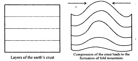
There are particularly two types of fold mountains, they are :
- Old fold mountains
- Young fold mountains.
Question 2.
State two chief differences between old and young fold mountains. Give examples.
Answer:
The mountains which were formed over 250 million years ago due to compression of earth’s crust are called old fold mountains. They have gentle slopes and low altitude due to weathering overtime eg. Urals in Russia, Aravallis in India and Appalachians in India.
The recently formed mountains i.e. about 25 million years ago are called young fold mountains. They are rugged and lofty. They comprise the world’s highest mountain ranges.
Eg. Rockies of North America, Alps, Andes, Himalayas and The great Dividing Range.
Question 3.
What are plateaux ? Why are they of great economic value?
Answer:
Plateaux (plural of plateau) are the uplifted sections of the earth’s crust that are almost flat or level and usually descend steeply to the surrounding lowlands. Aplateau is also sometimes referred to as a plain-in-the air or tableland. The land of a plateau is very fertile while the latter is a storehouse of mineral wealth. They are rich in minerals like gold, iron, copper, manganese, etc.
Question 4.
Mention the different types of plateaux.
Answer:
Types of Plateaux — Plateaus may be classified into the following categories on the basis of their formation, appearance and location:
Tectonic Plateau : A tectonic plateau is formed by the movement of the earth’s crustal plates. Tectonic movement causes a huge portion of the earth’s surface to rise. The plateau of South Africa and the Turkish-Iranian Plateau are examples of tectonic plateaus.
Volcanic Plateau : A volcanic plateau is a plateau formed by the spread of successive layers of lava on a particular region. When the lava cools, it solidifies and the successive sheets of lava finally form a raised tabeland or a plateau over a period of time. The extensive Columbia Plateau (in the north-western part of the U SA), the north-western part of the Deccan Plateau and the Malwa Plateau are examples of volcanic plateaus.
Dissected Plateau : These have irregular surface marked by canyons, gorges and steep, narrow valleys formed by the process of erosion. They are mostly common in dry and desert regions. The Colorado Plateau, through which the Grand Canyon passes, and the Brazilian Plateau (Mato Grosso) are examples of dissected plateaus.
Intermontane Plateau : These are surrounded by mountains and are the most common types of plateau. The most common example of an intermontane plateau is the Tibetan Plateau which is enclosed by the Himalayan Mountains to its south and the Kunlun Shan to its north.
Piedmont Plateau : Piedmont plateau is one that lies between a mountain and a plain or an ocean. Examples of piedmont plateaus are the Patagonia Plateau in South America and the piedmont Plateau of North America.
Question 5.
What is a basin ? Give an example.
Answer:
A basin is a depressed section of the earth’s crust surrounded by higher land. Many basins are found alongside plateau edges and form areas of inland drainage, i.e., the rivers flowing in the basin do not reach reach the sea. The Tarim and Tsaidam Basins of Asia and the Chad Basin ofnorth-central Africa are examples ofbasin.
Question 6.
Mention the different types of plains.
Answer:
Types of Plains: On the basis of formation, plains are grouped in three categories:
Structural Plains: Plains that lie near the coast of a sea or an ocean are called structural plains. Due to endogenetic movements, large, broad, flat areas of the sea floor are raised and appear on the surface. These types of plains are very flat and broad. The addition of sediments brought in by the sea waves over a period of time makes them broader and flatter than they originally were. Structural plains border all countries. The coastal plains of south-eastern USA near the Gulf Coast, which are part of the Great Plains, are one of the largest plains in the world. The plains of northern Russia and the central lowlands of Australia are other examples of structural plains.
Erosional Plains: Erosional plains are the result of the erosion of mountains, hills and plateaux. The eroded material is brought down to a low level by wind, rivers, rain, and ice. This kind of erosion caused by various agents gives rise to several types of plains. The plains of northern Canada, northern Europe and Kashmir in India are examples such plains.
Depositional Plains : Depositional plains are formed by sediments brought down on a large scale by natural agents such as moving ice, water and wind from the upper regions of mountains.
Question 7.
What is the importance of plains ?
Answer:
The importance of the plains are discussed below:
- Plains are important because they are good source of fresh fruits and vegetables.
- Plains are being ploughed by a farmer or a carabaos.
- Owing to the flat nature of the land. It is easy to construct roads and railways in plains.
- Plains have good and rich source of river which is very fertile for crops.
Question 8.
What is a peninsula ? Take the help of your atlas and name four major peninsulas of the world.
Answer:
A Peninsula is a piece of land that is surrounded by water on three sides and joined to a larger land mass. The peninsular plateau of India and the Malay Peninsula are two examples of peninsulas attached to the continent of Asia. Europe is a peninsula of peninsulas. Can you name the three large water bodies that surround it ? Also identify the smaller peninsulas that jut out from it.
Arabian peninsula, Deccan for major peninsula are peninsulas, Indo-China peninsula, Alaska peninsula.
Question 9.
Which two land masses does the Isthmus of Panama connect ?
Answer:
The Isthmus of Panama joins North America and South America with the Pacific Ocean on one side and the Atlantic Ocean on the other. The Isthmus of Suez joins Africa to Asia and separates the Mediterranean Sea and the Red Sea.
D. Answer the following questions in one or two paragraphs :
Question 1.
Name the major landforms on earth.
Answer:
The major landforms on earth are :
- Mountains — Most of the rivers originate from mountains. They are rich in minerals and metals deposits and support variety of flora and fauna.
- Plateau — They are storehouses of minerals such as gold, silver, iron, copper, manganese, etc.
- Valley — They are low-lying lands between hills formed by river flowing down the mountains or due to movement of earth plates.
- Plains — They are the most fertile landforms which support easy habitation.
Question 2.
List the continents according to size. Describe the two largest continents in detail.
Answer:
Continents are very large land masses that are surrounded by vast water bodies called oceans on all sides. They are the primary divisions of land. There are seven continents in the world.
Asia is the largest continent. It occupies about one-third of the land area of our planet. It is joined to the land mass of Europe and, thus, we use the term Eurasia for this combined land mass. The Ural Mountains, the Black Sea and the Caspian Sea separate the two continents. We find oceans on three sides of this land mass. To its north lies the Arctic Ocean, to its east is the Pacific Ocean and to its south is the Indian Ocean.
Africa is the second largest continent after Asia. It is surrounded by water bodies on all sides. In the north, the Mediterranean Sea separates it from Europe, and on its east is the Indian Ocean. The Atlantic Ocean in the west separates it from the two Americas. In Africa lies the largest desert of the world, the Sahara Desert.
Question 3.
Write short notes on
- Europe
- Australia.
Answer:
- Europe is smaller in size in comparison to the other continents mentioned above but has some of the most developed nations in the world. To its north is the Arctic Ocean. The Atlantic Ocean separates it from North America. It has the most indented coastline among the continents, which is why it has numerous ports and some of the finest harbours in the world.
- Australia is sometimes called ‘the Land Down Under’ as it lies to the south of the main land masses. It is also the smallest continent in size. As there is water on all sides—the Indian Ocean in the west, the South Pacific Ocean in the east, the Southern Ocean in the south, and the Arafura Sea in the north— it is an island and is, therefore, also called the ‘island continent’.
Question 4.
How is Mount Fuji of Japan different from the Vosges of Europe ?
Answer:
Mount Fuj i is a volcanic mountain formed when molten lava, ash, dust, etc. come out through cracks in earth’s crust and is accumulated in shape of high cone. Where as Vosges in Europe are formed by rupturing or fracturing of rock strata due to strain and is an example of block mountain.
Question 5.
Briefly describe the importance of mountains.
Answer:
Importance of Mountains:
- Mountains are a storehouse of water. Many rivers originate in the glaciers in the mountains.
- Reservoirs are made and the water from the mountains is used for irrigation and generation of hydro-electricity.
- The river valleys and terraces are most suitable for farming and cultivation of crops as the land is very fertile.
- Mountains support a rich variety of flora and fauna.
- Mountains also affect the climate of an area.
For example, the Himalayas cause rainfall in India by blocking the south-west monsoon winds. They also protect us from the cold winds of Central Asia in winter. - Mountains are also rich in mineral and metal deposits which are essential for industries.
- According to the United Nations Development Programme, mountains provide home for around 720 million people.
- The forests in the mountainous regions provide fuel, fodder, shelter and other products like gum, wild fruits, mushrooms, resins, etc. mountains provide an ideal holiday for tourists. They visit the for their natural scenic beauty and relaxation.
- Many recreation, sporting and tourism activities takes place in the mountains. Paragliding, hang gliding, river rafting and skiing are popular sports in the mountains.
Question 6.
How is a volcanic mountain formed ?
Answer:
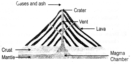
Volcanic mountains are formed when molten lava, ash, cinder and dust from deep inside the earth come out on the surface through cracks in the earth’s crust and accumulate in the shape of high cones.
The opening through which lava and other materials come to the surface is called a vent. The funnel-shaped depression at the top of a vent is called a crater.
Examples – Mountain Fujiyama in Japan, Mountain Mayon in the Philippines.
Question 7.
What is a V-shaped valley ?
Answer:
The valley which is formed by an exogenous process i.e. from the outside like a river flowing down the mountain eroding the soil and minerals form a V-shaped valley, eg. Rhine valley in Europe and Damodar valley in India.
Question 8.
Briefly explain
- peninsula
- island
- isthumus.
Answer:
- Peninsula: is a piece of land that is surrounded by water on three sides and joined to a larger land mass. The peninsular plateau of India and the Malay Peninsula are two examples of peninsulas attached to the continent of Asia. Europe is a peninsula of peninsulas. Can you name the three large water bodies that surround it ? Also identify the smaller peninsulas that jut out from it.
Arabian peninsula, Deccan for major peninsula are peninsulas, Indo-China peninsula, Alaska peninsula and Labrador peninsula. - Island : An island is a piece of land which is surrounded on all sides by water. India has two groups of islands – the Lakshadweep Islands in the Arabian Sea and the Andaman and Nicobar Islands in the Bay of Bengal.
- Isthumus : An isthmus is an elongated narrow piece of land, with water on each side, that joins two large land masses. For example, the Isthmus of Panama joins North America and South America with the Pacific Ocean on one side and the Atlantic Ocean on the other. The Isthmus of Suez joins Africa to Asia and separates the Mediterranean Sea and the Red Sea.
E. Draw neat, labelled, coloured sketches to show the characteristics of each of the following geographical features. Write a brief description alongside, explaining each of them
Question 1.
Block mountain
Answer:
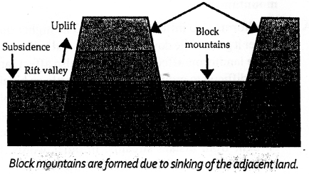
Block mountain—They are formed by rupturing or fracturing of rock strata due to strain. The land between the cracks inside the earth sink leaving upstanding blocks on either side making mountains.
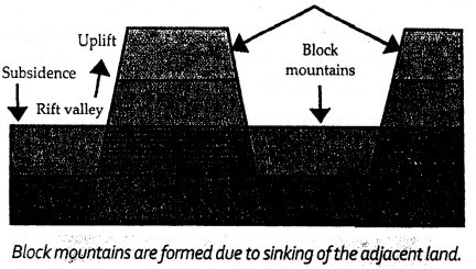
Question 2.
Volcanic mountain
Answer:
Volcanic mountain — They are built when molten lava, ash, cinder and dust from deep inside the earth comes out on the surface through cracks in the earth’s crust and accumulate in the shape of high cones.
The opening through which lava and other materials come to the surface is called a vent. The funnel-shaped depression at the top of a vent is called a crater.
Question 3.
Plateau
Answer:
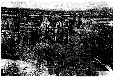
Plateau — It is the uplifted section of the earth’s crust that are almost flat or level and usually descend steeply to the surrounding lowlands, eg. Deccan Plateau and the Chota Nagpur plateau etc.
Question 4.
Rift valley
Answer:
Rift Valley—The rift valley is the type of valley that is formed when the land between the two faults sink i.e. the land between 2 block mountains is called rift valley.
F. Picture study
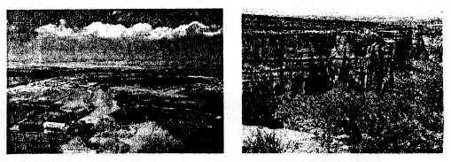
Look at the photographs of a plain and a plateau given here and answer the questions.
Question 1.
How does a plain look different from a plateau ?
Answer:
A plain is a flat piece of land where it is very easy to build houses, roads and carry agricultural practices whereas a plateau is a flat raised piece of land with steep slopes and high cliffs from the surrounding land which makes the soil rich in minerals like iron, copper, manganese.
Question 2.
Why are river plains thickly populated ?
Answer:
The river plains are thickly populated as it is easier to make buildings, construct roads and have all kinds of transportation facilities. The land is also very fertile, rich in minerals. Thus, making it easier for people to grow crops for their living.
Question 3.
How is life in the plains different from life in the mountains?
Answer:
Landforms also influence weather. The higher one goes the colder it gets, while down in the plains and valleys it is warmer. Since landforms affect climate they also affect farming. It is more difficult to grow crops and rear cattle on hillsides than it is in the plains. In the plains, it is easier for people to make roads and houses and to dig wells, unlike in the mountains where it is difficult and expensive to make them and water has to be brought from distant streams. In other words, life in the mountains is more difficult than life in the plains.