Natural Distribution Of Water In India
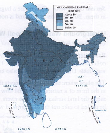
Water availability in India depends greatly on the seasonal monsoons. The monsoons bring heavy rain over most of the country between June and October. Only Tamil Nadu is the exception and receives over half of its rain from October to November. India ranges from places having waterless conditions (Thar Desert) to places with rainforest climate (North Eastern States). In general, the northern half of the country sees greater extremes in rainfall.
India has a large network of rivers too. The three ARABIAN major rivers, Indus, Ganga and the Brahmaputra originate in the Himalayas and drain nearly two- thirds of the land area. These rivers also account for nearly the same proportion of India’s total water resources. Water in these rivers is strongly influenced by the monsoons.
During the monsoons, water levels in rivers increase greatly and may result in floods. On the other hand, during the dry season, water levels go down quite a bit in most large rivers. Smaller tributaries and streams generally dry off completely. To regulate water flow in these rivers and distribute water more evenly throughout the year, large dams have been built on a number of rivers.
On the other hand, the mountainous and hilly regions of north and west do not allow adequate seepage. So, groundwater is mostly limited to lower-lying areas such surrounded by water on three sides as valleys. The peninsular areas of our country also do not allow proper absorption of water, and therefore do not have large continuous aquifers. Though the coastal plains are a rich source of groundwater, they can be contaminated by saltwater inflow caused by the over-pumping of groundwater. The Gangetic plains are, however, rich in groundwater as the aquifers keep getting recharged and restored.