ICSE Solutions for Class 8 Geography Voyage – Disaster Management

ICSE Solutions for Class 8 Geography Voyage – Disaster Management

ICSE SolutionsSelina ICSE SolutionsML Aggarwal Solutions

ICSE Solutions Class 8 GeographyHistory & CivicsBiologyChemistryPhysicsMaths

Exercises

A. Fill in the blanks

  1. Proper planning can help in limiting and minimizing damages and losses caused by natural or man-made disasters.
  2. Floods can be prevented in vulnerable areas by properly maintaining dykes along rivers.
  3. Rainwater harvesting goes a long way in replenishing the depleting supply of ground water.
  4. We should always turn off the knob of our LPG cylinders when it is not in use.
  5. Every house should have an emergency first-aid kit.

B. Match the following

ICSE Solutions for Class 8 Geography Voyage Chapter 6 Disaster Management 1
ICSE Solutions for Class 8 Geography Voyage Chapter 6 Disaster Management 2

C. Write true or false

1. The geographical location and landscape of India exposes it to earthquakes.
Answer. True.

2. When a natural disaster occurs in a developing country like India, it is the rich of the country that suffer the most.
Answer.False.
When a natural disaster occurs in a developing country like India, it is the poor of the country that suffer the most.

3. If you are outdoors during a tremor, the best strategy is to stand under a tree.
Answer. False.
If you are outdoors during a tremor, the best strategy is to stand away from a tree.

4. It is essential to plan in advance to prevent floods and contain the losses resulting from them.
Answer.True.

5. It is not possible to prepare in advance to mitigate the impact of a drought.
Answer. False.
It is possible to prepare in advance to mitigate the impact of a drought.

D. Answer the following questions in brief

Question 1.
What is disaster management ?
Answer:
Disaster management is the overall preparedness to handle the possibility of a disaster and efficient management of affected regions as well as people if such an incident were to occur. It involves plans and steps taken before, during and after a disaster to reduce the extent of suffering and damage.

Question 2.
Why is disaster management important ?
Answer:
A disaster – (natural or man-made) can strike anytime without warning. The disaster management is important because the geographical location and landscape of India exposes it to earthquakes and many kinds of weather- related disasters. In a developing country like India, usually the poor suffer the most. Therefore, it is extremely important for the government, the people and social organizations to be prepared with proper plans and arrangements to face any kind of disaster. Proper and prior planning can help in limiting and minimizing damages and losses resulting from any disaster – natural or man-made.

Question 3.
What safety measures can be followed against floods ?
Answer:
Floods can be prevented in vulnerable areas by properly maintaining dykes and embankments along rivers. The government and relief organisation must also have provisions of flood shelters in vulnerable places (along flood prone regions) so that people and livestock can be quickly evacuated and provided relief too. The government must also plan stationing rescue equipment near flood-prone areas. It should be possible to immediately deploy rescue boats and have communication lines open and functioning in order to rescue people caught functioning in order to rescue people caught in rising levels of water. There should be enough dry food, clean water and medicines made available to these people, affected by floods, so that spread of diseases can be stopped.

Question 4.
Mention any three safety measures against a fire.
Answer:
Few safety measures against fire are :

  1. Everyone should be acquainted with the common fire safety norms.
  2. We should take some time out to find out about the different
    kinds of fire extinguishers and the correct one to use in case of a fire. Fires are of different origins and we should make an effort to know more about this and the right extinguisher to use.
  3. While entering a public place such a cinema hall or auditorium, we should make note of the fire exits and all other possible exits.
  4. If a fire were to break out, we should avoid using the lift as a means of escape.
  5. We should undergo training in first-aid in case of a fire and ways to put out flames.
  6. If we light a matchstick to light a candle or the stove, we should also make sure that the matchstick is properly disposed of.
  7. We should always turn off the knob of our LPG cylinders when it is not in use. We should also always keep a kitchen window open so that any inflammable gas can dissipate instead of accumulating in the kitchen.

Question 5.
Write any two safety measures taken against biological disaster.
Answer:
In case of a biological disaster, we can take the following safety measures :

  1. People should inform the police and get away from any suspicious material that they see around them.
  2. The government should educate people through the mass media in case of a threat of a biological attack.
  3. People should not inhale such organisms and protect themselves by covering their faces.

Question 6.
What safety measures should be taken in case of a travel- related disaster?
Answer:
In case of a travel-related disaster, we can take the following precautions:

  1. Victims should be safely evacuated from the site of the accident and first aid should be administered at the earliest.
  2. We should always carry our identity cards with the blood group mentioned on it. Emergency contact number should be written on the identity card to get in touch with family or friends.

Question 7.
What role can social organizations play in disaster management ?
Answer:
There are various groups such as the Red Cross, UN agencies and NGOs (non-governmental organization) which provide aid at the time of disasters. These organizations focus on meeting people’s emergency needs. They provide shelter, food and medicines to the victims. They work to decrease the sense of isolation and abandonment that disaster victims often feel.

E. Answer the following questions in one or two paragraphs

Question 1.
What safety measures should be taken during an earthquake ?
Answer:
Safety measures during earthquakes :
If you are indoors during an earthquake, three steps – drop, cover and hold-could save you from receiving severe injuries. If your building is shaking immediately drop to the ground and take cover under a bed or table. If you are outdoors during a tremor, the best strategy would be to move towards an open area – away from trees, buildings, electricity poles, transmission towers, etc. stay away from bridges and flyovers during an earthquake and even for a while after it has subsided.

Question 2.
Write a note on the safety measures to lessen the impact of droughts.
Answer:
Safety measures to lessen the impact of droughts are :

  1. Using water sources such as rivers, lakes and ponds carefully and maintaining them is important to tide people over during times of no rain.
  2. Rainwater harvesting goes a long way in replenishing the depleting supply of groundwater. The government and social welfare organizations should teach and enable people to harvest rainwater to restore their water reserves.
  3. Building of check dams also helps to collect run-off water in hilly areas.
  4. We should stop cutting down trees along river banks and other water bodies. Instead, we should plant more trees. Trees help in drawing moisture and rainfall to a region.
  5. We should stop wasteful use of water in our daily life.

Question 3.
Write any five safety measures against fires.
Answer:
Few safety measures against fire are :

  1. Everyone should be acquainted with the common fire safety norms.
  2. We should take some time out to find out about the different kinds of fire extinguishers and the correct one to use in case of a fire. Fires are of different origins and we should make an effort to know more about this and the right extinguisher to use.
  3. While entering a public place such a cinema hall or auditorium, we should make note of the fire exits and all other possible exits.
  4. If a fire were to break out, we should avoid using the lift as a means of escape.
  5. We should undergo training in first-aid in case of a fire and ways to put out flames.
  6. If we light a matchstick to light a candle or the stove, we should also make sure that the matchstick is properly disposed of.
  7. We should always turn off the knob of our LPG cylinders when it is not in use. We should also always keep a kitchen window open so that any inflammable gas can dissipate instead of accumulating in the kitchen.

Question 4.
Write some ways in which the government can tackle man¬made disasters.
Answer:
The government can tackle the man-made disasters in many ways :

  1. Government of developing countries should allot a substantial sum of money from their budget to set up special disaster management departments.
  2. Efficient forecasting and warning systems should be installed.
  3. Modern tools of information technology must be used for managing such situations.
  4. The government should set up organizations to coordinate relief work and give top priority to rehabilitation and reconstruction plans.
  5. The communication network should be strengthened to ensure that entire regions do not get cut off in the eventuality of disasters like earthquakes and tsunamis.
  6. Inspection team should be send regularly to check safety regulations at public places like hotels, malls, theatres, etc.

Question 5.
What role can people play in disaster management ?
Answer:
When a disaster occurs, the external aid comes late, so the people should be skilled in first-aid techniques and in ways to help other critically injured people. Every house should have a first -aid kit. There should be awareness about the disasters and preventions for them. For example, the hotel management could help save a lot of lives in case of a fire if it follows the government regulations on emergency exits, escape routes and fire extinguishers. The residents of a war zone may construct undergrounds bunkers that can protect them from air strikes by enemy nations. People living in areas prone to tsunami may plant more trees or create tsunami walls, along the coastline to prevent extensive damage. Also people should be alert to suspicious elements, such as terrorists, who are capable of launching attacks and causing man-made disasters.

Question 6.
Briefly explain the steps to be taken to mitigate the impact of cyclone.
Answer:
In order to mitigate the impact of cyclone following, precautions can be taken :

  1. People living in cyclone-prone regions must be alert and keep a track of warnings, announcements and instructions from I the meteorological department and the Disaster Warning System (DWS), television news and radio broadcasts. They should carefully follow instructions given on radio and television and act accordingly to avoid danger. A timely warning can save many lives.
  2. Cyclone-prone areas should have pre-constructed shelters that are known to everyone.
  3. The houses in these areas should be designed to withstand strong winds.
  4. We must conserve coastal vegetation such as mangrove forests as these act as windbreaks and reduce the impact of waves.
  5. Emergency kit, food, water and medicines should be kept ready in a waterproof bag.
  6. People should take precautions against snakebites, fallen electric poles, wires, etc.

Question 7.
What precautions should be taken against nuclear disaster?
Answer:
In case of a nuclear disaster, we can take the following precautions :

  1. It is advisable to stay indoors with all doors and windows shut as radioactivity cannot penetrate through solids walls.
  2. Any dust or liquid that gets deposited outside should not be touched as it may be contaminated.
  3. Official broadcasts for instructions should be followed.
  4. Nuclear plants should not be established in populated areas and such plants should never be constructed in an earthquake – prone region.

Question 8.
What safety measures can be taken in case of

  1. a chemical disaster
  2. terror attack?

Answer:

  • A chemical disaster : In case of a chemical disaster, we can take the following precautions :
    (a) Chemical industries should not be allowed to function in populated areas.
    (b) The government agencies should conduct regular safety and pollution checks of these chemical industries. The government should be equipped and must have a proper plan to handle emergencies. It should be prepared with antidotes and other relief measures in case of poisoning.
  • Terror attack: In case of a terror attack, we can take the following precautions:
    (a) People should always be alert and report to the concerned authorities about any suspicious persons in their neighbourhood.
    (b) Any unattended bags or articles should not be touched and should immediately be reported to the police.
    (c) All important telephone numbers such as those of police, ambulance, neighbors, etc. should be kept handy.

F. Picture study
The photograph shows children practicing the ‘drop, cover and hold’ strategy during an earthquake.

ICSE Solutions for Class 8 Geography Voyage Chapter 6 Disaster Management 3
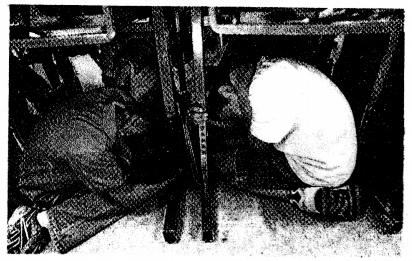
What are the precautions that should be taken during an earthquake and the tremors that follows?
Answer:
If you are indoors during an earthquake, three steps – drop, cover and hold – could save you from receiving severe injuries. If your building is shaking, immediately drop to the ground and take cover under a bed or table. If you are outdoors during a tremor, the best strategy would be to move towards an open area – away from trees, buildings, transmission towers, electricity poles, etc. Stay away from bridges and flyovers during an earthquake, and even for a while after it has subsided.
It is very important to follow proper norms while constructing buildings, bridges, flyovers and dams. Old buildings should be strengthened through the process of retrofitting. We must keep a first-aid box at home and in school. It can be very useful in case of an emergency.

Extra Questions

Question 1.
Which simple strategy or three steps can protect people from getting severely injured during an earthquake while indoor ?
Answer:
Drop-cover and hold.

Question 2.
When and why was the Disaster Management Act passed in India ?
Answer:
On 23 December 2005, the Government of India enacted the Disaster Management Act, which led to the creation of the National Disaster Management Authority (NDMA) headed by the Prime Minister and State Disaster Management Authorities (SDMAs) headed by the respective Chief Minister of different states. The main vision of this body is to build a safer and disaster-resilient India.

Question 3.
Give full form of NDMA and SDMA and NGO
Answer:

  • NDMA – National Disaster Management Authority
  • SDMA – State Disaster Management Authority
  • NGO – Non-Governmental Organization.

Question 4.
What do you mean by Dyke ?
Answer:
Dyke is a long wall or embankment built to prevent flooding from the sea.

Question 5.
What do you mean by a school ? Disaster Management System ?
Answer:
A School Disaster Management system is the process of assessment and planning, physical protection and response capacity development designed to

  1. Protect students and the staff from physical harm;
  2. Minimize disruption and ensure the continuity of education for all children;
  3. Develop and maintain a culture of safety.

6. Fill in the blanks

  1. Proper planning can help in limiting and minimizing damages and losses resulting from any disaster-natural or man-made.
  2. If you are outdoor during an earthquake, move towards an open area.
  3. Unlike most of the other natural disasters, a drought is not a sudden occurrence.
  4. Check dams help to collect run-off water in hilly areas.
  5. Trees help in drawing moisture and rainfall to a region.
  6. We should make an effort to know more about the different kinds of fire extinguishers to use in case of fire.
  7. While entering a public place like cinema hall or auditorium, we should make note of the fire exits.
  8. Regular inspection should be done by the government to check if public places adhere to safety regulations.
  9. Rainwater harvesting is the process of collecting and storing rainwater for future use.


ICSE Solutions for Class 8 Geography Voyage – Human Resources in India

ICSE Solutions for Class 8 Geography Voyage – Human Resources in India

ICSE SolutionsSelina ICSE SolutionsML Aggarwal Solutions

ICSE Solutions Class 8 GeographyHistory & CivicsBiologyChemistryPhysicsMaths

Exercises

A. Fill in the blanks

  1. A resource is something that helps us to meet our needs and create wealth.
  2. The working population of a country includes both skilled and unskilled human resources.
  3. Scientists and doctors are example of skilled human resources.
  4. Unskilled human resources include people with little education.
  5. Good education changes the attitude and behaviour of people.

B. Write true or false

1. A skilled person can easily be replaced.
Answer. False.
A skilled person cannot easily be replaced.

2. IT professionals are unskilled resources.
Answer. False.
IT professionals are skilled resources.

3. Unskilled workers have a high income.
Answer. False.
Unskilled workers have a low income.

4. Education improves the understanding of people.
Answer. True.

5. India has 16.9 per cent of the world’s land area.
Answer. False.
India has 16.9 per cent of the world’s population.

C. Match the columns

ICSE Solutions for Class 8 Geography Voyage Chapter 11 Human Resources in India 1
Answer:
ICSE Solutions for Class 8 Geography Voyage Chapter 11 Human Resources in India 2

D. Answer these questions briefly

Question 1.
What do you understand by the term human resources ?
Answer:
People are considered a resource as they have the skill and ability to exploit other natural resources and help a country in its growth. Thus, people are considered and called as human resource.

Question 2.
What are the differences between skilled and unskilled human resources ?
Answer:
Skilled human resources :

  1. These people have specialised training to perform their work.
  2. These people have different levels of formal education.
  3. These people do jobs that require knowledge and skill and they cannot be easily replaced.
  4. They generally earn high income.
  5. Examples – doctors, engineers, scientist, lawyer, teacher, etc.

Unskilled human resources :

  1. These people have very limited skills.
  2. The people have very little formal education.
  3. Their jobs do not require any specialized skills and they can be easily replaced.
  4. They generally earn low wage.
  5. Examples : workers at construction sites, domestic help, sanitation workers, etc.

Question 3.
Which areas in India are thickly populated ?
Answer:
The vast northern plains like Uttar Pradesh, Bihar and West Bengal and coastal plains are thickly populated areas in India.

Question 4.
Define sex ratio.
Answer:
Sex ratio is defined as the number of females per thousand males.

Question 5.
Why is the sex ratio low in Punjab and Haryana ?
Answer:
The sex ratio is low in Punjab (893) and Haryana (877) because of :

  • Greater mortality rates of female babies
  • Girl child being killed by abortion.

E. Answer these questions in one or two paragraphs

Question 1.
Why is human resource important for a country ?
Answer:
Human resource is important for a country as they can help a country meet its needs and help in its economic growth. Human beings are the most important resource of a country because they can use their intelligence and ability to exploit other resources such as land, minerals and water in the best possible way.

Question 2.
Explain briefly the impact of skilled human resource on the socio-economic development of the country.
Answer:
Human resources play an important role in the overall development of a country.
Human resources are required for the proper utilization of a country’s natural resources like mineral, water, forest, etc. because the optimal utilization of these resources is necessary for the economic development of the country.
Skilled and the knowledgeable human resources make a rational use of all resources at their disposal and increase the volume of output and income for a country. They are well versed in using modem technology and thus help to bring development in a country. They help to increase production by producing a variety of goods and services of high quality.
The development of human resource works as a tool for economic change. It can make people knowledgeable, skilled and physically healthy. This can lead to a change in the attitudes of the people, develop their thought process and improve the quality of their life. Such changes encourage the spirit of entrepreneurship and motivate people to work hard, take risks, do research and explore their innovative capacity.

Question 3.
Discuss the role of health and education in developing human resources.
Answer:
Health and education play a very important role in the development of human resource. Health people can work well and do things quickly. They are able to utilize other resources in a better way. Unhealthy people are unable to perform well and spend money on their treatment which could otherwise be used to acquire other valuable resources or enhance their skills.
Education also plays an important role in the development of human resource. When a person receives good education, it improves his or her level of understanding increases their capacity and mental efficiency to produce more and changes the attitude and behaviour of people as they gain more confidence in themselves. A country with high proportion of well educated people can achieve rapid economic growth.

Question 4.
What do you know about the rural-urban population composition in India ?
Answer:
Population of India may be classified into rural and urban population depending on where the people live.
Rural population — They live in villages. They generally earn their livelihood from agriculture, livestock rearing and other primary activities. In India, more people live in rural areas (about 69 per cent). In recent years, a large number of people have migrated from rural to urban areas in search of job, good education and better living conditions.
Urban population — They live in cities and towns. They earn their livelihood from jobs in offices, factories, trade, transport and services. In India, about 31 per cent people live in urban areas. Migration from rural to urban areas have had an impact on the population of urban areas.

Question 5.
Give an account of the distribution of population in India.
Answer:
India is the second most populous country in the world after China. We have just 2.4 per cent of the land area of the world but have about 16.9 per cent of the world’s population. The last census conducted in 2011 recorded the Indian population at 1, 210, 193, 422. Out of these about 69% live in rural areas and 31% in urban areas. Northern plains have highest concentration of population which includes states like Uttar Pradesh, Bihar and West Bengal. The coastal plains are also thickly populated. The population is thin in the north-eastern states and in the desert region of the west. The Deccan plateau has a moderate population concentration. In India, the sex ratio is 940, which means on an average, we have 940 females to every 1000 males.

Question 6.
Write a note on sex ratio in India.
Answer:
Sex ratio is defined as the number of females per thousand males. In India, on an average, there are more males than females- 940 females for every 1000 males. In some states, the sex ratio is low like only 877 females to every 1000 males in Haryana and 893 females to every 1000 males in Punjab. There are a number of reasons. Greater mortality rates of female babies and the girl child being killed at birth are two important reasons for poor sex ratio in these states.
Kerala and Puducherry have the highest sex ratio with 1084 females to 1000 males in Kerala and 1038 females to every 1000 males in Puducherry. High literacy rate is the reason for this. The fewer number of females per 1000 males in India is a major concern. Which can raise many social issue.

F. Picture study.
ICSE Solutions for Class 8 Geography Voyage Chapter 11 Human Resources in India 3

ICSE Solutions for Class 8 Geography Voyage Chapter 11 Human Resources in India 4

Question 1.
In these pictures (i) and (ii) identify the two types of human resources in terms of skills.
Answer:

  • A worker at a construction site unskilled person.
  • An IT Professional skilled person.

Question 2.
Mention a characteristics of each type.
Answer:

  1. Unskilled human resource include people with little formal education and very limited skills. Workers at construction sites, sanitation workers, domestic helps, etc. are examples of unskilled human resource. Their jobs do not require any specialized skill and these people can easily be replaced. They generally earn a low wage.
  2. A skilled person is someone who has specialized training to perform their work. These people have different levels of formal education. Scientists, lawyers, etc. are examples of skilled human resource. These people perform tasks that require knowledge and skill, and they cannot be easily replaced. They generally earn a high income.

Extra Questions

Question 1.
What do you mean by mortality rate ?
Answer:
The number of deaths per 1000 live births is called mortality rate. It is also called as death rate.

Question 2.
Name the two categories of working population (human resource).
Answer:
The working population of a country is divided into :

  • Skilled human resource
  • Unskilled human resource

Question 3.
What is the impact of skilled human resource on the socio-economic development of India ?
Answer:
Education is essential for the socio-economic development of a country and plays a key role in the development of skilled human resources. The Indian government has invested heavily in human resource development because it promotes economic growth in country. Education and skill training is necessary for achieving the growth targets. In India, skill training needs attention except for limited professions like engineers, doctors and computer professionals. The government has started the ‘Skill India Mission’ for the youth in order to meet the demands skilled workers and for the economic growth of the nation. Through this mission the unemployed, school dropouts, women, ordinary graduates, etc. are given training based on their knowledge and ability which will prepare them for jobs. Training is also to be given to carpenters, masons, black smiths, cobblers, welders, tailors, weavers, etc.

Question 4.
What is HDI ?
Answer:
The Human Development Index (HDI), devised by the United Nations Development Programme (UNDP), measures the level of development in a country. This index is calculated on the basis of per capita income, education, literacy and life expectancy of the population. India ranked 130 among 188 countries in the Human Development Report 2015.

Question 5.
What is census ?
Answer:
The counting of the country’s population conducted every 10 years in India is called Census.

Question 6.
Mention various factors that affect the distribution of population in our country.
Answer:
The factors that affect the distribution of population in our country are physical features, climate, availability of natural resources and the level of industrialization.

Question 7.
Why are northern plains thickly populated ?
Answer:
Northern plains have fertile land which is best suited for agriculture. Transport and communication facilities are well developed and employment opportunities are also good.

8. Fill in the blanks

  1. Skilled human resource cannot be easily replaced while unskilled human resource can be easily replaced.
  2. A country with a high proportion of well-educated people can achieve rapid economic growth.
  3. India’s population is more than the population of North America, South America and Australia put together.
  4. India has 2.4 % of the land area of the world but about 16.9% of the world’s population.
  5. In India sex ratio is 940 females for every 1000 males.
  6. Human beings are the most important resource of a country as they can exploit other resources.
  7. Health and education play an important role in developing human resources.
  8. The Northern plains are thickly populated in India while north eastern states and desert in the west are thinly populated.
  9. Sex ratio is the number of females per thousand males.

ICSE Solutions for Class 8 Geography Voyage – India: Location, Extent, Political and Physical Features

ICSE Solutions for Class 8 Geography Voyage – India: Location, Extent, Political and Physical Features

ICSE SolutionsSelina ICSE SolutionsML Aggarwal Solutions

ICSE Solutions Class 8 GeographyHistory & CivicsBiologyChemistryPhysicsMaths

Exercises

A. Fill in the blanks

  1. There are seven union territories in India.
  2. The Tropic of Cancer divides India into two halves.
  3. The Himalayas literally means abode of snow.
  4. The Lakshadweep Islands have been formed by the growth of corals.

B. Identify who I am

  1. A river that divides the Peninsular Plateau of India into the Malwa and the Deccan plateaux : Narmada.
  2. A vast sandy low-lying plain in north-west Rajasthan : The Thar Desert.
  3. Barren Island is the only volcanically active island of India.
  4. The longest river of south India : Godavari.

C. Distinguish between each of the following pairs

Question 1.
The Eastern and the Western Ghats
Answer:
Western Ghats :

  1. They extend from the mouth of river Tapi to Kan niyakumari.
  2. The average height is 1,200 m but in some parts it rises to 2,440 m.
  3. They are continuous.
  4. They are the source of rivers that flow across the Deccan.
  5. They are steep and rugged, and rise abruptly from the arrow Western Coastal Plains.
  6. They lie close to the Arabian Sea.

Eastern Ghats :

  1. They extend from the Mahanadi Valley up to the Nilgiri Hills.
  2. The average height is 450 m, rarely exceeding 1,200 m.
  3. They are not continuous. Many rivers flow through them.
  4. They have gentle slopes that rise from the Eastern Coastal Plains.
  5. They lie at some distance from the Bay of Bengal.

Question 2.
The Eastern and the Western Coastal Plains
Answer:
Western Coastal Plains :

  1. They stretch from Kachchh in the north to Kanniya-kumari in the south.
  2. They lie between the Western Ghats and the Arabian Sea.
  3. They are narrower than the Eastern Coastal Plains.
  4. They do not have deltas, only estuaries and lagoons.
  5. They have different names in different parts—they are known as the Konkan Coast in Maharashtra, The Kanara Coast in Karnataka and the Malabar Coast The Kerala.
  6. They lie in the states of Gujarat, Maharashtra, Goa. Karnataka, and Kerala.
  7. Their important ports are Kandla, Mumbai, Marmagao, Mangalore, and Kochi.

Eastern Coastal Plains :

  1. They stretch from the mouth of the river Ganga in the north to Kanniyakumari in the south.
  2. They lie between the Eastern Ghats and the Bay of Bengal.
  3. They are wider than the Western Coastal Plains.
  4. They are composed of the deltas of all the majorrlvers of the Deccan.
  5. They have different names in different parts—they are known as the Northern Circars in the region north of the river Godavari and the Coromandel Coast in the region south of the river Godavari.
  6. They lie in the states of Odisha, Andhra Pradesh, and Tamil Nadu.
  7. Their important ports are Vishakhapatnam, Paradwip, Chennai, and Tuticorin.

Question 3.
The Himalayan and peninsular rivers
Answer:
The Himalayan Rivers :

  1. They are also called as North Indian Rivers.
  2. The three important rivers are the Ganga, the Indus and the Brahmaputra.
  3. They are longer and slow moving.
  4. They are snow fed and hence perennial.
  5. These rivers are navigable.
  6. These rivers are more suitable for irrigation.

The Peninsular Rivers :

  1. They are also called as South Indian Rivers.
  2. The six important rivers are the Mahanadi, the Godavari, the Krishna, the Kaveri, the Narmada and the Tapi.
  3. They are shorter and fast flowing.
  4. They are rain-fed and not always perennial.
  5. These rivers are not navigable.
  6. These rivers are less suitable for irrigation.

Question 4.
The east and the west-flowing rivers of south India.
Answer:
The east-flowing rivers of South India :

  1. The main rivers are Mahanadi, Godavari, Krishna and Kaveri.
  2. These rivers drain into the Bay of Bengal.
  3. These rivers make deltas at their mouth.
  4. These rivers have large- amount of water.
  5. These rivers originate from the western Ghats and flow eastwards.

The West-flowing rivers of South India :

  1. The main rivers are Narmada and Tapi.
  2. These rivers drain in the Arabian Sea.
  3. These rivers do not make deltas.
  4. These rivers have less amount of water.
  5. These rivers originate in Central India and flow westwards.

D. Answer the following questions in brief

Question 1.
Do you think it is right to use the term ‘subcontinent’ for India and its neighbouring countries ?
Answer:
Yes, it is right to use the term ‘subcontinent’ for India and its neighbouring countries because although they are a part of Asia, they have developed their own distinct physical and cultural identity. This is due to the presence of protective barrier of the Himalayas which isolates these countries from the rest. of Asia.

Question 2.
How many states and union territories does India have ?
Answer:
India has 29 states and 7 union territories.

Question 3.
What do you know about the Purvanchal ranges ?
Answer:
The hills of the north-east India are collectively called the Purvanchal ranges. They lie along the eastern borders of India. Their average elevation is less than 3,000 m. They consist of several hill ranges such as Patkai Bum, Naga, Mizo, Garo, Khasi and Jaintia Hills.

Question 4.
Name the three divisions of the Great Northern Plains and the rivers responsible for their formation.
Answer:
The three divisions of the Great Northern Plains are :

  1. The Ganga Plains in the centre : They are formed by the alluvial deposits of the river Ganga and its tributaries such as Yamuna, Gomti, Ghaghara, Gandak, Chambal, Betwa and the Son. It is in U.P., Bihar and West Bengal.
  2. The Punjab Plains in the West : They are formed by the alluvial deposits of the tributaries of the rivers Indus — The Satluj, the Beas, the Ravi, the Chenab and the Jhelum. It is in Punjab and Haryana.
  3. The Brahmaputra Valley in the East: It is formed by the Brahmaputra River. It lies in Assam.

E. Answer the following questions in one or two paragraph:

Question 1.
Explain how India has benefited from its location.
Answer:
The location of India has helped in the development of trade and commerce. The existence of seas on three sides has encouraged international trade. From ancient times, India has had political, economic and cultural links with other countries. Today, India provides a link between the East and the West world. Its central position between the two world has helped the development of its own industries and trade.

Question 2.
Explain how the Himalayas have greatly influenced the life of the people of India.
Answer:
The Himalayas exert a significant influence on the life of the people of India in several ways.

  • They form a natural boundary between India and China.
  • They serve as a climatic barrier by preventing the entry of the cold winds from Central Asia and preventing the rain¬bearing monsoon winds from leaving India.
  • They are a source of perennial rivers such as the Indus, the Ganga, and the Brahmaputra and their tributaries.
  • Their rugged terrain is ideal for hydroelectric power generation.
  • The mountain slopes are forested. These forests provide different types of timber and forest products.
  • The Himalayas have beautiful hill Stations Shimla, Darjeeling, Mussorie, etc.

Question 3.
Explain why the Great Northern Plains are densely populated.
Answer:
The Great Northern Plains are densely populated because of the following reasons

  1. The fertile soil of the plains has helped in the development of agriculture.
  2. Its soft soil has made irrigation possible.
  3. Their flatness has promoted growth and development of a dense network of road and rail transport.
  4. Their rivers and tributaries provide cheap water transport.

Question 4.
Describe the Andaman and Nicobar Islands, and the Lakshadweep Islands.
Answer:
There are two Island groups of India :

  1. The Andaman and Nicobar Islands — They lie in the Bay of Bengal. They are about 550 in number and are of volcanic origin. Barren Island is the only volcanically active island. They are separated by a wide channel called the Ten Degree channel.
  2. The Lakshadweep Islands — They lie in the Arabian Sea. They have been formed by the growth of corals and are fewer in number than the Andaman and Nicobar Islands. Many of them are uninhabited. These islands form the smallest union territory of India.

F. Picture study.
ICSE Solutions for Class 8 Geography Voyage Chapter 9 India Location, Extent, Political and Physical Features 1
This is a photograph of the river Ganga.

Question 1.
Which are the states through which this river flows?
Answer:
The river Ganga, which is about 2,510 km long, flows through four states of India – Uttarakhand, Uttar Pradesh, Bihar and West Bengal.

Question 2.
Name any two left-bank tributaries of the river.
Answer:
Its left bank tributaries rise from the glaciers in the Himalayas. The Ramganga, the Gomti, The Ghaghara, the Gandak and the Kosi are the main left bank tributaries.

G Map work
Mark and label each of the following in an outline map of India

  1. The Tropic of Cancer
  2. The neighbouring countries of India
  3. The Palk Strait
  4. The Arabian Sea and the Bay of Bengal

Answer:

ICSE Solutions for Class 8 Geography Voyage Chapter 9 India Location, Extent, Political and Physical Features 2

Extra Questions

Question 1.
Describe the location of India.
Answer:
India lies entirely in the northern and eastern hemispheres. It extends from 8°4’N to 37°6’N latitudes and 68°7’E to 97°25 ‘E longitudes. The Tropic of Cancer divides India into two parts by passing through it. The approximate area is 3.3 million sq km. The Himalayas separate it from the rest of Asia. It has many neighbouring countries with whom it makes a subcontinent. South of the Tropic of Cancer lies peninsular India-triangular mass of land projecting into the Indian Ocean. It is surrounded by water on three sides. The Arabian Sea in the west, the Bay of Bengal in the east and the India Ocean in the south. The central position of India between the East and the West world has helped in the development of trade and commerce.
India at a Glance
Latitudinal extent: 8°4′ N – 37°6’ N
Longitudinal extent: 68°7’E – 97°25’E
Area : 32, 87, 263 sq. km
North-south extent: 3,214 km
East-west distance : 2,933 km
Length of land frontier : 15,200 km
Length of coastline : 7,500 km
Number of states : 29
Number of union territories : 7
Capital: New Delhi
Total population (According to 2011 Census) : 1.21 billion
Average population density : 382 persons per sq km

Question 2.
Name the countries that form India subcontinent.
Answer:
India, Pakistan, Nepal Bhutan, Bangladesh and Sri Lanka form the Indian subcontinent.

Question 3.
What is the percentage of urban and rural population in India ?
Answer:
Percentage of urban population in India – 31%
Percentage of rural population in India – 69%

Question 4.
What is taken as the standard meridian for India and why?
Answer:
The 82 ×/2 °E longitude passing through Allahabad is taken as the standard meridian for India because it lies in the middle of the long east-west extent of India. For every 1° of longitude, there is a difference of 4 minutes. So there is a difference of two hours in the local time of Gujarat in the west and Arunachal Pradesh in the east. To avoid confusion and have a uniform time in the entire country, standard meridian has been formed.

Question 5.
Name the neighbouring countries of India.
Answer:
Pakistan, Afghanistan, China, Nepal, Myanmar, Bangladesh, Bhutan, island country of Sri Lanka and the Maldives.

Question 6.
What separates India from Sri Lanka ?
Answer:
Sri Lanka is separated from India by the Palk Strait and the Gulf of Mannar.

Question 7.
Name the three water bodies which surround the India Peninsular.
Answer:

  1. The Arabian Sea in the west
  2. The Bay of Bengal in the east
  3. The Indian Ocean in the south.

Question 8.
On what basis were the states of India reorganised after independence ? Name the states and union territories of India along with their capitals. (Political divisions).
Answer:
The states were re-organised on the basis of language after independence. There are 29 states and 7 union territories of India at present.

StateCapital
1.       Andhra Pradesh

2.       Arunachal Pradesh

3.       Assam

4.       Bihar

5.       Chhattisgarh

6.       Goa

7.       Gujarat

8.       Haryana

9.       Himachal Pradesh

10.   Jammu and Kashmir

11.   Jharkhand

12.   Karnataka

13.   Kerala

14.   Madhya Pradesh

15.   Maharashtra

16.   Manipur

17.   Meghalaya

18.   Mizoram

19.   Nagaland

20.   Odisha

21.   Punjab

22.   Rajasthan

23.   Sikkim

24.   Tamil Nadu

25.   Tripura

26.   Uttar Pradesh

27.   Uttarakhand

28.   West Bengal

29.   Telangana

1.       Hyderabad

2.       Itanagar

3.       Dispur

4.       Patna

5.       Raipur

6.       Panaji

7.       Gandhinagar

8.       Chandigarh

9.       Shimla

10.   Srinagar

11.   Ranchi

12.   Bengaluru

13.   Thiruvananthapuram

14.   Bhopal

15.   Mumbai

16.   Imphal

17.   Shillong

18.   Aizawl

19.   Kohima

20.   Bhubaneshwar

21.   Chandigarh

22.   Jaipur

23.   Gangtok

24.   Chennai

25.   Agartala

26.   Lucknow

27.   Dehra Dun

28.   Kolkata

29.   Hyderabad

Union Territories – Capital           
1. Andaman and Nicobar Islands – Port Blair
2. Chandigarh – Chandigarh
3. Dadra and Nagar Haveli – Silvassa
4. Daman and Diu – Daman
5. Lakshadweep – Kavaratti
6. Delhi – Delhi
7. Puducherry – Puducherry
8. India – New Delhi

Question 9.
Name the point in the Himalayas where the boundaries of five countries meet. Name the countries.
Answer:
Indira Col in the Himalayas is the point where the boundaries of five countries meet. The countries are :
India, Pakistan, Afghanistan, China and Tajikistan.

Question 10.
Name the six main physical divisions of India.
Answer:

  1. The Northern Mountains
  2. The Great Northern Plains
  3. The Peninsular Plateau
  4. The Coastal Plains
  5. The Thar Desert
  6. The Islands

Question 11.
What do the Northern Mountains consist of ?
Answer:
The Northern Mountains consist of the Himalayas and the hills of north-east India and together they form the northern and north-eastern boundaries of the country.

Question 12.
The Himalayas are rising even now. Comment.
Answer:
The Himalayas are relatively young mountains formed from the sediment deposited in the ancient Tethys Sea. The Tethys Sea lay between ancient land masses of Laurasia in the north and Gondawanaland in the south about 185 million years ago. The two land masses moved closer due to movements inside the earth and then collide with each other. This caused the seabed of the Tethys Sea to fold upwards, forming the mountains. The Himalayas are rising even now.

Question 13.
Name the three main ranges of the Himalayas. Compare them.
Answer:
The Himalayas consist of three parallel ranges of mountains

  1. The Greater Himalayas (Himadri)
  2. The Lesser Himalayas (Himachal)
  3. The Outer Himalayas (Shiwalik)

ICSE Solutions for Class 8 Geography Voyage Chapter 9 India Location, Extent, Political and Physical Features 3

Question 14.
Name few passes or gaps in the Himalayas that serve as important passages through the northern mountain wall.
Answer:
Shipki La, Thaga La, Nathu La and Jelep La.

Question 15.
What is the location and extend of the Great Northern Plains ? Which rivers have formed it ?
Answer:
The Great Northern Plains lie between the Northern Mountains in the north and the Peninsular Plateau of India in the south. They extend from Punjab in the west to the Brahmaputra. Valley in the east for about 2,400 km. These plains are formed by three major rivers — the Indus, the Ganga, and the Brahmaputra, and their tributaries.

Question 16.
Where do the Ganga and the Brahmaputra join and where do they drain ?
Answer:
The Ganga and the Brahmaputra join in Bangladesh where they flow as one river — the Padma — which drains into the Bay of Bengal. Together these rivers have built the largest delta in the world the Sundarbans.

Question 17.
Write a short note on the Peninsular Plateau.
Answer:
The Peninsular Plateau is an ancient land mass made up of hard crystalline rocks of igneous and metamorphic origin. The plateau is triangular in shape, broad in the north and tapering towards Kanniyakumari in the south. The plateau extends from the Aravalli Range in the west up to the Chota Nagpur Plateau in the east. The Peninsular Plateau is divided by the river Narmada into two parts —

(a) The Malwa Plateau :

  1. Bounded by the Vindhya Range in the south, the Aravalli Range in the west and the Chota Nagpur Plateau in the east.
  2. Drained by the rivers Chambal, Sind, Betwa, Ken, Son, and Damodar.

(b) The Deccan Plateau :

  1. Bounded by the Satpura Range in the north, the hills of the Western Ghats in the west and the hills of the Eastern Ghats in the east.
  2. Drained by the rivers Mahanadi, Godavari, Krishna, and Kaveri.

Question 18.
How have the rocks of the Deccan Plateau formed ?
Answer:
The rocks that make up the Deccan Plateau have solidified from the outpourings of lava from large fissures in the earth. These spread out in sheets to form one of the most extensive and thickest accumulations of lava flows in the world.

Question 19.
Write a short note on Thar desert.
Answer:
The Thar Desert is a vast low-lying plain with sandy ridges and shifting sand dunes. It lies mainly between the Aravallis in the east and the Sind Desert of Pakistan in the west. This desert lies primarily in north-western Rajasthan. The region receives very less rainfall, less than 25 cm annually and hence lacks water resources. River Luni is the only river that carries little water. The India Gandhi Canal has changed the desert into fertile land to some extent. Crops such as wheat, barley, grapes and melons grow here now.

Question 20.
Name the two categories of rivers of India.
Answer:
On the basis of the area of origin, the rivers of India are divided into the categories :

  1. the north Indian rivers or the Himalayan rivers — which originate from glaciers in mountains.
  2. the south Indian rivers or peninsular rivers — which are fed by rains.

Question 21.
Name the five tributaries of river Indus.
Answer:
The Satluj, the Beas, the Ravi, the Chenab and the Jhelum are the five main tributaries of the Indus (Panchnadi).

Question 22.
Name the states from where the river Indus, Ganga and Brahmaputra flow in India.
Answer:
The river Indus flows through the state of Jammu and Kashmir (from Tibet) and enters Pakistan.
The river Ganga flows through 4 states — Uttarakhand, Uttar Pradesh, Bihar and West Bengal.
The river Brahmaputra flows through Arunachal Pradesh and Assam.

Question 23.
Which river is called the ‘Ganga of the South’ ?
Answer:
The Godavari river.

Question 24.
Define the following:

  1. Alluvial plain
  2. A Pass
  3. Tributary

Answer:

  1. Alluvial plain — It is a plain formed by the sedimentary deposits of a river.
  2. Pass — It is a gap through a mountain range that provides a route for travelling through it.
  3. Tributary — It is a small river that flows into a larger river, thereby contributing water to it.

Question 25.
How are rivers important to humans ?
Answer:
Rivers are very important to humans as :

  1. They are a source of water for domestic, agricultural and industrial purposes and of food and livelihoods.
  2. They are also a source of transportation.
  3. The are often used for recreational and religious activities.

26. Fill in the blanks

  1. India is a part of the continent of Asia.
  2. India is seventh largest country and has second largest population in the world.
  3. India lies entirely in the northern and eastern hemispheres.
  4. The 82 1/2° E longitude is the Standard Meridian for India.
  5. The Himalayas separate India from the rest of the Asia.
  6. Indira Col is the point in the Himalayas where the boundaries of five countries meet.
  7. Delhi is referred to as the National Capital Territory of India.
  8. The Himalayas are the source of perennial rivers such as the Indus, the Ganga and the Brahmaputra rivers.
  9. The Great Northern Plains extend from Punjab in the west to the Brahmaputra Valley in the east.
  10. The alluvial soil of the river valleys/plains is very fertile.
  11. The largest delta in the world built by the Ganga and the Brahmaputra is Sundarbans.
  12. The Peninsular Plateau of India is triangular in shape.
  13. On either side of the Peninsular Plateau of India are the Coastal Plains of India.
  14. Coconut Palms grow profusely in the Coastal Plains of India.
  15. The Thar Desert receives less than 25 cm rain annually.
  16. Luni is the only significant river in the Thar desert but carries very little water.
  17. The Andaman and Nicobar Islands are separated by a wide channel called the Ten Degree channel.
  18. The Lakshadweep Islands lie at a distance of 200-400 km from the Malabar Coast.
  19. The Lakshadweep Islands is the smallest union territory of India.
  20. The river Indus and river Brahmaputra originate in Tibet before entering India.
  21. The river Ganga has it source in the Gangotri glacier.
  22. River Brahmaputra enters India in Arunachal Pradesh from Tibet.
  23. The west flowing rivers of the Peninsular rivers drain into the Arabian Sea.
  24. The margins of the Deccan Plateau consist of hills called the Eastern Ghats in the east and the Western Ghats in the west.

Map Skills

1. On a Political Map of India, show all the States and Union territories of India along with their Capitals.

ICSE Solutions for Class 8 Geography Voyage Chapter 9 India Location, Extent, Political and Physical Features 4

2. On an outline map of India, show the important physical features.

ICSE Solutions for Class 8 Geography Voyage Chapter 9 India Location, Extent, Political and Physical Features 5