ICSE Solutions for Class 6 Geography Voyage – Elements of a Map

ICSE Solutions for Class 6 Geography Voyage – Elements of a Map

ICSE SolutionsSelina ICSE SolutionsML Aggarwal Solutions

APlusTopper.com provides step by step solutions for ICSE Solutions for Class 6 Geography Voyage. You can download the Voyage Geography ICSE Solutions for Class 6 with Free PDF download option. Geography Voyage for Class 6 ICSE Solutions all questions are solved and explained by expert teachers as per ICSE board guidelines.

ICSE Solutions Class 6 GeographyHistory & CivicsBiologyChemistryPhysicsMaths

A. Choose the correct answer

1. This is not one of the five basic elements of a map

  1. a title
  2. a north line
  3. conventional symbols
  4. a twine

2. This is one of the intermediate directions.

  1. north
  2. south
  3. north-east
  4. east

3. Places lying halfway between south and south-west will have a

  1. south direction
  2. west direction
  3. south-south-west direction
  4. west-south-west direction

4. This is the ratio of the distance between two places on a map to the actual distance between the same two places on the ground.

  1. scale
  2. plan
  3. symbol
  4. sketch

5. The numerator of a representative fraction is always

  1. 1
  2. 2
  3. o
  4. 100

B. Answer the following questions in brief.

Question 1.
What are the cardinal directions ?
Answer:
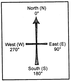
N may or maynot be shown the top of the map or plan indicates the North direction. If no such symbol is shown, then the top portion of the map is taken as the North and the bottom, right and left of the map as the South, the East and the West respectively. These directions—North, South, East and West — are called the cardinal directions.
ICSE Solutions for Class 6 Geography Voyage Chapter 2 Elements of a Map 1

Question 2.
What is meant by the scale of a map ?
Answer:
Scale on a map is the distance shown in the map. The scale is given just below the map.
Scale helps us to find out the correct distance between various points on a map. In a scale there is always a proportion between the dimension of the map and the actual area they represent.

Question 3.
Which three ways are used to represent the scale of a map ?
Answer:
The proportion which exists between the map and actual surface of the Earth is called the scale. A scale can be expressed in three ways

  1. by a statement
  2. by representative fraction
  3. linear scale or graph

Question 4.
Convert the statement 1 cm = 100 km into an R.F. scale.
Answer:
1 km = 1000 m, 1 m = 100 cm
100 km = 100 × 1000 × 100 = 1,00,00,000 cm
Since RF = Distance on the map in cm
RFscale = 1 / 1,00,00,000 = 1:100,00,000

Question 5.
What method would you use to measure the length of a river ?
Answer:
We use twine method to measure the length of a river. In the twine method, a twine is placed along the feature to be measured from one end to the other, carefully following all the curves and bends. The length of the twine is then measured in centimetres or inches using a ruler or linear scale. Thereafter, this length is converted into kilometres or miles using the scale of the given map.

Question 6.
What is a legend or key ?
Answer:
A legend or key is an essential feature of any map. It explains the colours, signs, and symbols used in the map. It uses different colours to show the height or depth of an area above or below sea level respectively. It is provided near the top or the bottom of the map, either on the left-hand or right-hand side.

Question 7.
What are conventional signs and symbols ?
Answer:
A variety of colourful signs and symbols are used on maps to show natural and man-made features on maps. These signs and symbols give plenty of information and are simple to draw and understand.
Some of these symbols are internationally recognized as they have been determined by convention, i.e., these symbols have been agreed upon and accepted internationally. Therefore, they are also called conventional signs and symbols.

Question 8.
Name the features that are shown in blue, green, and brown colours on a map.
Answer:

  • Blue : water bodies such as oceans, seas, bays, gulfs, lakes, rivers, streams.
  • Green : lowlands or plains, both coastal and those built by rivers.
  • Brown : hills, mountains, plateaux.
  • Yellow : hot deserts.
  • White : cold deserts, snow-covered regions.

Question 9.
Name the line of latitude that divides the earth into the northern and southern hemispheres.
Answer:
The line of latitude that divides the earth into the northern and southern hemispheres is the equator (0°).
A network of horizontal and vertical lines or latitudes and latitudes drawn on a map or globe is called the grid system. Latitudes are the horizontal east-west lines. The longest latitude is the equator (0°).

Question 10.
What are the latitudinal and longitudinal extents of India? Use your atlas to find the answer.
Answer:
The latitudinal extent of India is 20.59° N and the longitudinal extent of India is 79° E.

C. Answer the following questions in one or two paragraphs.

Question 1.
What are the five different elements of a map ? Explain them briefly ?
Answer:
The following are the five essential features of a map.

  1. Title – It indicate the subject of the map. e.g, distribution of natural vegetation, water bodies, climate, etc.
  2. Scale – It denotes the relationship between map distances and actual ground distances. _
  3. Direction – It refers to the cardinal direction, i.e., North, South, East and West, Conventionally, a map is aligned with the North towards the top.
  4. Key or Legend – It explains the meaning of the symbols that are used in the map.
  5. Grid system, usually formed by the cross-conjugation of the lines of longitudes and latitudes.

Question 2.
Explain the functions of the north line and legend on a map.
Answer:
The direction on a map is measured with the help ofthe north line.
All maps have a key or a legend that explains the colours, signs and symbols used in them.
The equator (0° latitude) divides the earth into the hemispheres — the northern and the southern hemispheres. All lines of latitude are measured from the equator.

Question 3.
What is the difference between the cardinal directions and the intermediate directions ? Draw a diagram to shthe intermediate directions.
Answer:
The four major directions i.e. North, South, East and West are called cardinal directions. The directions in between these four cardinal directions are called intermediate directions.
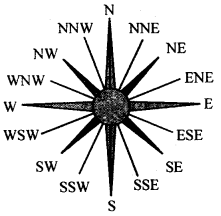
ICSE Solutions for Class 6 Geography Voyage Chapter 2 Elements of a Map 2
E.g North, East, North-North east, South west etc.

Question 4.
Describe any two ways of representing a map scale.
Answer:
Map scales can be represented as
(a) Verbal or statement scale—i.e. the scale is stated in words as 1 cm = 5 km or 1 cm to 5 km. It means 1 cm on the map is equal to 5 km on ground.
(b) Representative fractions — In this system, the numerator expresses the distance on map and denominator represents the actual distance on ground. Both should have same units i.e. 1 cm on map represents 50,000 cm on ground.
R.F = distance on map cm / distance or ground cm

Question 5.
Why is the key or legend an important element of a map?
Answer:
A legend or key is an essential feature of any map. It explainsthe colours, signs, and symbols used in the map. It uses different colours to show the height or depth of an area above or below sea level respectively. It is provided near the top or the bottom of the map, either on the left-hand or right-hand side.

Question 6.
Explain why colours are used in maps?
Answer:
Colours play a significant role in maps. They make maps attractive to look at and easy to understand and interpret. On physical maps, the different colours are conventionally used in this way:

  • Blue : water bodies such as oceans, seas, bays, gulfs, lakes, rivers, streams.
  • Green : lowlands or plains, both coastal and those built by rivers.
  • Brown : hills, mountains, plateaux.
  • Yellow : hot deserts.
  • White : cold deserts, snow-covered regions.

Question 7.
What are lines of latitude ? Give examples ?
Answer:
Latitudes are the horizontal east-west lines. The longest latitudes is the equator (0°). All the other latitudes are parallel to the equator and thier length decreases towards the poles. Examples:

  1. The Tropic of Cancer, at 2314°, is located north of the equator. It is the northernmost limit to which the direct rays of the sun are received.
  2. The Tropic of Capricorn, at 23 V20, is located south of the equator. It is the southernmost limit to which the direct rays of the sun are received.

Question 8.
What is the grid system ? Why is it important ?
Answer:
A network of horizontal and vertical lines or latitudes and longitudes drawn on a map or globe is called the grid system.
The grid system is an important feature of maps. It helps in locating places on the surface of the earth. For example, if you wanted to locate a place, you would look for its latitude and longtitude. The location of the place would be at the intersection of its latitude and longitude.

D. Look closely at the political map of India in your atlas and make a note of your observations and calculations in your notebook.

Question 1.
What is the scale of the map ?
Answer:
A scale is the ratio between the distance on a map and the actual distance on the ground.

Question 2.
Calculate the N-S and E-W extents of India.
Answer:
N-37°6\ S-8° 4′ and E 97°25\ W 68° T

Question 3.
Using the scale, calculate the distance between Delhi and Kolkata, Chennai and Thiruvananthapuram, and Mumbai and Panaji in kilometres.
Answer:
1 cm = 61 km
Delhi and Kolkata 24 cm = 24 × 61 = 1464 km
Chennai and Thiruvananthapuram 10.3 cm = 628 km appropriate
Mumbai and Panaji 6.50 cm = 6.5 × 61 = 397 km

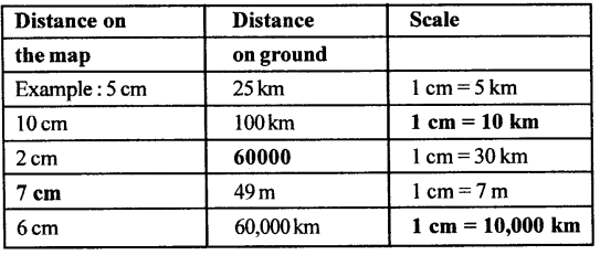
E. Complete the following chart
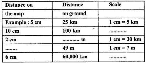
ICSE Solutions for Class 6 Geography Voyage Chapter 2 Elements of a Map 3
Answer:
ICSE Solutions for Class 6 Geography Voyage Chapter 2 Elements of a Map 4

F. Practical work.

Question 1.
Draw a linear scale to show two men standing 30 m apart. Use the scale 1 cm = 3m.
Answer:
ICSE Solutions for Class 6 Geography Voyage Chapter 2 Elements of a Map 5

Question 2.
A rectangular plot of length 200 m and width 125 m was bought by a businessman to set up a cosmetic factory. Draw this plot reduced to size using the scale 1cm = 25m. Show your work in class.
Answer:
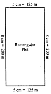
ICSE Solutions for Class 6 Geography Voyage Chapter 2 Elements of a Map 6

G Picture study
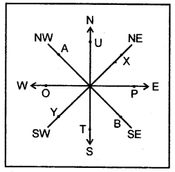
Study the diagram alongside and fill in the blanks with appropriate directions:
Example: A lies to the north-west of B.
1. T lies to the – of U.
2. P lies to the – of 0.
3. 0 lies to the – of P.
4. Y lies to the – of X.
5. U lies to the – of T.
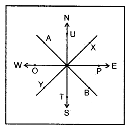
ICSE Solutions for Class 6 Geography Voyage Chapter 2 Elements of a Map 7
Answer:
1. T lies to the south of U.
2. P lies to the E of O.
3. O lies to the W of P
4. Y lies to the SW of X.
5. U lies to the N of T.
ICSE Solutions for Class 6 Geography Voyage Chapter 2 Elements of a Map 8

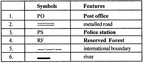
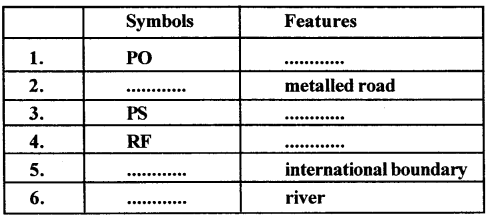
H. Complete the following table with the help of the list of conventional signs and symbols given in this chapter
ICSE Solutions for Class 6 Geography Voyage Chapter 2 Elements of a Map 9
Answer:
ICSE Solutions for Class 6 Geography Voyage Chapter 2 Elements of a Map 10

Let’s Do something

Question 1.
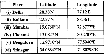
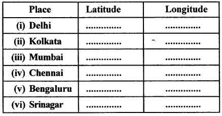
Find latitudes and longitudes :
You will need an atlas. Turn to the index pages and find the latitudes and longitudes of these Indian cities.
ICSE Solutions for Class 6 Geography Voyage Chapter 2 Elements of a Map 11
Answer:
ICSE Solutions for Class 6 Geography Voyage Chapter 2 Elements of a Map 12

Question 2.
Make a clay globe in your art class and mark the major latitudes and longitudes using the following colours. Blue, green and brown.
Answer:
Do it yourself.
ICSE Solutions for Class 6 Geography Voyage – South America : Climate, Natural Vegetation, Wildlife; Mineral and Power Resources

ICSE Solutions for Class 6 Geography Voyage – South America : Climate, Natural Vegetation, Wildlife; Mineral and Power Resources

ICSE SolutionsSelina ICSE SolutionsML Aggarwal Solutions

APlusTopper.com provides step by step solutions for ICSE Solutions for Class 6 Geography Voyage. You can download the Voyage Geography ICSE Solutions for Class 6 with Free PDF download option. Geography Voyage for Class 6 ICSE Solutions all questions are solved and explained by expert teachers as per ICSE board guidelines.

ICSE Solutions Class 6 GeographyHistory & CivicsBiologyChemistryPhysicsMaths

POINTS TO REMEMBER

  • The climate of South America is influenced by its location, presence of the Andes Mountains, prevailing winds, nearness to seas and oceans, and the impact of ocean currents.
  • The vast continent of South America has a climate that varies from the equatorial climate in most of Brazil, to the desert climate of the Atacama and Patagonian Deserts.
  • Some areas of Venezuela, Guyana, and Brazil also experience tropical climate. There is a small stretch of central Chile which experiences Mediterranean climate. Southern Chile has a maritime climate.
  • Different climates have influenced the natural vegetation found in South America. Forests exist in areas that receive heavy rainfall throughout the year such as the equatorial forests of the Amazon Basin. Grasslands predominate in regions that record maximum rainfall during the summers such as the grasslands in Guyana and Brazil. Deserts exist in areas that receive hardly any rainfall such as the Atacama and Patagonian Deserts. Mountain vegetation grows in the Andes and Mediterranean vegetation is found in central Chile.
  • The wildlife of South America includes several unusual species such as the anaconda, birds such as the egret, rhea, and condor, and animals such as the guanaco, vicuna, and llama.
  • Hardwood trees like mahogany, rosewood, and rubber are found in the selvas. Brazil nuts, balsa, cinchona for quinine, gum, resins, and dyes are other products obtained from these forests. Yerba mate is an important tree that grows in the Eastern Highlands.
  • Rivers like the Amazon, Orinoco, and Parana provide inland water transport. Brazil, Argentina, Paraguay, and Venezuela have developed hydroelectric power projects.
  • South America is rich in minerals ranging from crude oil, copper, diamond, gold to silver. This is what attracted the Europeans to settle in this continent.

IMPORTANT TERMS

Campos : the tropical grasslands in central Brazil.
Gran Chaco : lowland alluvial plain in interior south-central South America.
Armadillo : an animal found in South America with a hard shell made of pieces-Of bone.
Lguana : a large tropical lizard found in South America.

EXERCISES

A. Fill in the blanks.

  1. The tropical grasslands of Guyana are called llanos.
  2. The coca tree is a native peruvian tree.
  3. The quebracho tree grows in the Gran Chaco.
  4. The pampas vegetation in Argentina consists of short, soft and nutritious grasses.
  5. The galapagos Islands are inhabited by giant turtles.
  6. Wax obtained from caranauba palm trees are used for making shoe polish, furniture poolish, lipstick and candles.
  7. Quinine is obtained from the bark of cinchona trees.
  8. Chile leads in the production of copper.

B. Find the odd one out in each of the following groups and say why.

  1. Llanos, pampas, campos, selvas
  2. Rubber, cinchona, pine, ebony
  3. Tapir, piranha, sloth, puma
  4. Jaguar, vicuna, llama, alpaca
  5. Cactus, pine, scrub, prickly pear

Answer:

  1. Selvas – As all other are grass
  2. Pine
  3. Tapir, pranha – piranha is a reptile
  4. Jaguar – These three belong to camel family
  5. Pine

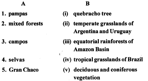
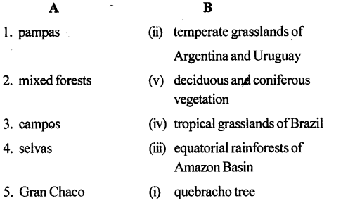
C. Match the columns.

ICSE Solutions for Class 6 Geography Voyage Chapter 11 South America Climate, Natural Vegetation, Wildlife Mineral and Power Resources 1
Answer:
ICSE Solutions for Class 6 Geography Voyage Chapter 11 South America Climate, Natural Vegetation, Wildlife Mineral and Power Resources 2

D. Answer the following questions in brief.

Question 1.
How does the shape of the continent affect the climate of th£ southern part of South America ?
Answer:
Due to its tapering size or shape, the southern part of South America gets the moderating influence of the oceans and thus has mild climate.

Question 2.
Mention some of the factors that affect the climate of South America.
Answer:
A large part of South America lies within the tropical zone and is, therefore, hot. The apparent movement of the sun has an impact on die climate of South America. The climate is, however, r also influenced by a number of other factors such as the presence of the Andes Mountains, the height of a place above sea level, prevailing winds, nearness to seas and oceans, and die impact of ocean currents such as die warm Brazilian Current and the cold Peru Current.

Question 3.
Name the summer and winter months in large parts of South America.
Answer:
As it is mainly located in the southern hemisphere, a very large part of South America experiences summer in December and early January and winter in June-July.

Question 4.
Which winds bring heavy rainfall to the Guiana Highlands and Brazil ?
Answer:
The North-east and South-east Trade Winds bring heavy rain to the Guiana Highlands and Brazil.

Question 5.
Why is the Atacama a desert ? Is it a tropical desert or a temperate desert ?
Answer:
The Northern and central Andes block North East and South East Trade Winds which bring rain from the Atlantic Ocean to the Guiana Highlands and Brazil. Therefore, the regions west of the Andes do not receive any rain and are very dry and hot and the Atacama Desert is located here. The Atacama is a tropical desert.

Question 6.
Name some of the forest resources from the selvas of South America.
Answer:
The selvas or equatorial forests are important for hardwood trees such as mahogany, rosewood, and rubber. The camaiiba palm tree yields wax, which is used for making shoe polish, furniture polish, lipstick, and candles. The bark of the cinchona tree yeild quinine, a medicine used for treating malaria. Balsa, which is a lightweight wood, Brazil nus, gum, resins, and dyes are other products obtained from selvas.

E. Answer the following questions in one or two paragraphs.

Question 1.
Quito is located near the equator yet it has a cool pleasant climate throughout the year. Explain.
Answer:
Quito is the capital of Ecuador. It is situated close to the equator. In spite of its equatorial location, it has a pleasant climate throughout the year as it is situated high in the Andes.

Question 2.
Briefly describe the vegetation and wildlife of the selvas.
Answer:
The selvas or equatorial forests are important for hardwood trees such as mahogany, rosewood, and rubber. The camauba palm tree yields wax, which is used for making shoe polish, furniture polish, lipstick, and candles. The bark of the cinchona tree yields quinine, a medicine used for treating malaria. Balsa, which is a lightweight wood, Brazil nuts, gum, resins, and dyes are other products obtained from selvas.
Yerba mate is an important tree of the Eastern Highlands. The leaves of this tree are used to make a tea-like beverage. The Gran Chaco region grows quebracho (the woid’quebracho’ means ‘axe-breaker’), a hardwood tree which is a source of tannic acid used in leather tanning. The eastern slopes of the Andes and the confierous forests of Chile have softwood trees, which are important sources of Wood pulp for the paper industry.
Colourful birds, monkeys, insects and snakes such as the python and anaconda, reptiles such as crocodiles and alligators and fishes including the piranha are found in the Amazon forests.

Question 3.
What do you know about the tropical grasslands of South America.
Answer:
These grasslands have long grasses and are known as the llanos in Guyana and the campos in Brazil. There are scattered trees between the grasses of varying heights.

Question 4.
Describe the temperate grasslands of South America.
Answer:
These are called the pampas in north-eastern and central Argentina and Uruguay. The vegetation consists of short, soft, and nutritious grasses. This is a fertile tree-less area which is well suited to cattle grazing, dairying, and wheat cultivation. Vast amounts of wheat are grown here for export.

Question 5.
What kind of wildlife can be found in the Amazon forests?
Answer:
Colourful birds, monkeys, insects and snakes such as the python and anaconda, reptiles such as crocodiles and alligators and fishes including the piranha are found in the Amazon forests.

Question 6.
South America has rich mineral reserves. Write a brief description of the chief mineral deposits.
Answer:
Brazil has one of the world’s largest deposits of iron ore and also has some coal and vast oil reserves. Lake Maracaibo in Venezuela has rich deposits of mineral oil. This makes up for the lack of coal. About 15 per cent of the world’s crude oil comes from this region of South America. Venezuela is the biggest exporter of oil in South America and is next only to the Arab countries. It is a member ofthe Organization of Petroleum Exporting Countries (OPEC).
Chile is the world’s leading producer of copper. The largest copper mine in the world is at Chuquicamata in northern Chile. Peru is another important copper producer in South America. The Atacama Desert is still rich in nitrates, which are important for making fertilizers. Bolivia is one of the leading countries in tin production in the world. Gold is found in Colombia, Brazil, Ecuador, and Peru. Bolivia and Peru have silver mines. Reserves of two rare minerals—platinum and vanadium—are found in the Andes. Bauxite is mined in Guyana and Suriname.
South America is rich in minerals ranging from crude oil, copper, diamond, gold to silver. This is what attracted the Europeans to settle in this continent.

F. On a blank outline map of South America, mark the following.

  1. Use red arrows to show the North-east Trade and South¬east Trade Winds and purple arrows to show the North Westerlies.
  2. Colour in dark green the extent of the selvas.
  3. Use light green to show the extent of the temperate grasslands of Argentina and Uruguay.
  4. Colour in yellow the Patagonian and Atacama Deserts.
  5. Write the words llama, rhea, pine, and puma in regions where they are found.
  6. Write ‘P’ for petroleum, ‘S’ for silver and ‘C’ for copper in any two countries producing these minerals.

Answer:
See Textbook pages 120, 122 & 124

G Picture study.
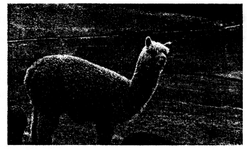
Identify the animal seen in the photograph and answer the following questions

ICSE Solutions for Class 6 Geography Voyage Chapter 11 South America Climate, Natural Vegetation, Wildlife Mineral and Power Resources 3

Question 1.
Name an area in South America where you can see it.
Answer:
They are seen in the central and southern regions of Peru.

Question 2.
How do these animals adapt to the climate?
Answer:
These animals live in an area of high altitude where the temperature can change rapidly and the ground can be frosted over haífthe year

Question 3.
Give one significant usefulness of this animal.
Answer:
The alpaca are domesticated as the alpaca provides fine wool

ICSE Solutions for Class 6 Geography Voyage – Major Crops

ICSE Solutions for Class 6 Geography Voyage – Major Crops

ICSE SolutionsSelina ICSE SolutionsML Aggarwal Solutions

APlusTopper.com provides step by step solutions for ICSE Solutions for Class 6 Geography Voyage. You can download the Voyage Geography ICSE Solutions for Class 6 with Free PDF download option. Geography Voyage for Class 6 ICSE Solutions all questions are solved and explained by expert teachers as per ICSE board guidelines.

ICSE Solutions Class 6 GeographyHistory & CivicsBiologyChemistryPhysicsMaths

POINTS TO REMEMBER

  • Crops can be divided into two broad categories—food crops (grains that are consumed as food) and cash crops (crops that are sold in the market for cash, such as cotton).
  • Rice is the staple food for the majority of the people. It requires plenty of water.
  • China is the world’s largest rice-producing country, followed by India.
  • Wheat is a crop that grows well in temperature regions.
  • Sugar cane is grown in the tropical and sub-tropical regions of the world.
  • India is the second-largest producer of sugar cane after brazil.
  • China, India and Pakistan are important cotton-growing countries in the world.
  • Jute is known as the ‘golden fibre’.
  • India is the largest jute-producing country in the world and West Bengal is the biggest jute-producing state in India.
  • The Green Revolution refers to the spectacular increase in the yield of food grains in India in the 1960s.

IMPORTANT TERMS

Bagasse : The fibrous matter that remains after sugar cane stalks have been crushed to extract their juice.
Ethanol : A volatile, flammable, colourless liquid.
Green Revolution : The spectacular increase in the production of food grains in the 1960s in India.
HYV seeds : High yielding variety of seeds introduced during the Green Revolution to increase crop production.
Kharif crops : Crops that grow through the summer season in India.
Molasses : A thick, black, sweet sticky liquid produced when sugar is refined.
Rabi crops : Crops that grow through the winter season in India.
Zaid crops : Crops that grow from March to June.

THINK AND ANSWER

Is global warming likely to change agricultural patterns all over the world ?
Answer:
Global warming modifies the rainfall pattern, amplifies coastal erosion, lengthens the growing season in some regions, melts ice-caps and glaciers and alters the range of some infectious diseases.
Warmer temperature extends the growing season. The plants need more water to keep growing throughout the season or they will dry out. The milder winters will fail to kill dormant insects, increasing the risk of large damaging infestation.

VALUES AND LIFE SKILL

The green Revolution led to a spectacular increase in crop production in India. Yet, poor fanners could not really benefit from this because they could not afford the new and expensive varieties of seeds.
What, in your opinion, could the government have done to improve the condition of poor farmers?
Answer:

  1. Govt, should give best prices for their production.
  2. Govt, should provide subsidised Machinery, HYV seeds Pesticides etc.
  3. Govt, should pay off the borrowings/bank loans made by the poor farmer.

EXERCISES

A. Fill in the blanks

  1. There are three main crop growing seasons in India — Kharifrabi and zaid.
  2. Cash crops are grown for cash or for commercial purposes.
  3. Bagasse is the crushed sugar cane fibre that is used for the manufacture of paper and fibre boards.
  4. Use of new variety of seeds led to a spectacular increase in crop production in India in the 1960s.
  5. The green revolution led to farmers taking loans and incurring large debts.

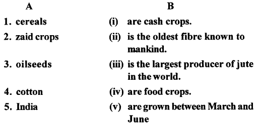
B. Match the columns
ICSE Solutions for Class 6 Geography Voyage Chapter 6 Major Crops 1
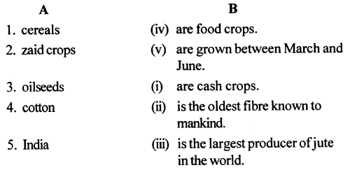
Answer:
ICSE Solutions for Class 6 Geography Voyage Chapter 6 Major Crops 2

C. Answer the following questions in brief

Question 1.
What are kharif crops ? Give one example.
Answer:
The crops which are grown in july and harvested in November are called Kharif crops, eg. rice, maize, etc.

Question 2.
Which are the major rice-producing regions in India ?
Answer:
The major rice – producing regions in India are states of Odisha, Andhra Pradesh, Telangana, Gujarat, Karnataka, Madhya Pradesh, Punjab and Haryana.

Question 3.
What are cash crops ? Give two examples.
Answer:
The crops mainly grown for making profit are called cash crops, eg. sugarcane, oil seeds, etc.

Question 4.
What climatic conditions are suitable for the cultivation of cotton ?
Answer:
Cotton requires a long frost-free period of 6-8 months in a year. It requires plenty of sunshine and dry weather during harvest.

Question 5.
What are the climatic conditions required for growing tea?
Answer:
Tea—Tea is a perennial plant that grows well in both tropical and subtropical regions. It requires a moderately hot and humid climate. Temperatures between 13° and 32° C are ideal for growing tea. Tea requires frequent and well-distributed rain of 200 cm or more throughout the year.

Question 6.
Name the major coffee producing regions of India.
Answer:
Karnataka is the leading coffee producing state followed by Kerala and Tamil Nadu. Other states where some coffee is grown are Andhra Pradesh, Odisha, and the north-eastern states.

Question 7.
What are high yielding varieties of seeds ?
Answer:
The new dwarf and semi-dwarf varieties of seeds, especially of wheat which has lead to Green Revolution are called high yielding varieties of seeds.

D. Answer the following questions in one or two paragraphs

Question 1.
What are the crop-growing seasons in India ? List the different types of crops that grow in each season.
Answer:
There are mainly three crop-growing seasons in India.

  • Kharif season — From July to November — eg. Rice, sugarcane, maize.
  • Rabi season — From October to February — eg. Wheat, barley, mustard.
  • Zaid season — From March to June — eg. Musk melon, sweet potatoes, watermelon, etc.

Question 2.
Write a brief note on the cultivation of wheat in India.
Answer:
Wheat is mainly grown in winter months as it requires a temperature between 10° C and 15° C during growing season and 20°C to 25°C to ripen.
Uttar Pradesh is the leading wheat producing state in India.

Question 3.
What is sugarcane ? What are the different products that are made from sugar cane ?
Answer:
Sugarcane is a hardy crop that is cultivated in the tropical and sub-tropical regions of the world. It belongs to the grass family. It grows as large jointed stalks measuring 2 to 6 m in height. Products: It is from these stalks that raw sugarcane juice is obtained for making sugar. The juice is further processed to make products like molasses, jaggery (gur), ethanol, industrial alcohol, etc. The crushed fibre, known as bagarse, is used for the manufacture of paper and fibre boards.

Question 4.
What are the main areas of tea production in India and in the world ?
Answer:
In India the main tea-producing regions are Assam, West Bengal, Tamil Nadu and Kerala. Other tea growing regions of India are Sikkim, Tripura, Arunachal Pradesh, and the Kangra Hills in northern India. The finest quality tea is grown on the hill slopes of Darjiling in West Bengal. China and Sri Lanka produce the best quality tea. India is the second largest tea producer in the world after China.

Question 5.
Describe the climatic conditions required for growing coffee.
Answer:
Coffee is a tropical and a sub-tropical plant that grows well on hill slopes. Tropical coffee grows best between 1,200 m and 2,000 m. Sub-tropical coffee grows best at altitudes between 600 m and 1,200 m. It is sensitive to frost and direct heat and therefore grows well in the shade of evergreen trees. Coffee requires rainfall between 160 cm and 200 cm annually. Humidify ranging between 70 and 80 per cent is ideal for the growth of coffee. Coffee plantations must avoid strong sunshine and heavy monsoon rains for better growth. Soil should be rich and fertile and well-drained. Labour for plucking, sowing, weeding, pruning, packaging and handling of coffee should be well-trained, skilled and cheap.

Question 6.
Give any three climatic conditions most suitable for growing rubber.
Answer:
Rubber is a tropical tree that requires a hot and humid climate. It requires rainfall between 200 cm and 300 cm annually and plenty of sunshine. The ideal temperature should range between 20° C and 34° C. Rubber requires high humidity above 80 per cent. Rubber trees are planted on slopes to avoid water stagnation.

Question 7.
What was the Green Revolution ? List its main features.
Answer:
Green Revolution is the increase in the production of food grains in 1960’s in India.
Its main features are :

  1. Traditional agricultural practices gave way to modem and scientific methods of cultivation.
  2. There was marked decrease in shifting agriculture in many parts of India.
  3. In India, farmers had the opportunity for multiple cropping, thereby increasing their income considerably.
  4. The genetically improved high yielding varieties of seeds of wheat, rice and maize were the most important component of the Green Revolution.

Question 8.
Why was the Green Revolution not beneficial for poor farmers ?
Answer:
Green Revolution was not beneficial for poor farmers as they couldn’t afford to buy expensive seeds, fertilizers, machinery, etc. It lead to unemployment as new machinery replaced manual labour. It encouraged farmers to take loans but ended up with large debts on the farmers.

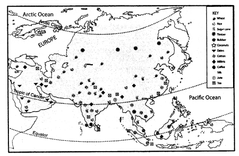
E. On an outline map of Asia mark the following

  1. Rice growing regions in green
  2. Wheat growing regions in pink
  3. Sugar cane growing regions in red
  4. Cotton growing regions in purple
  5. Jute growing regions in brown
  6. Tea growing regions in yellow
  7. Coffee growing regions in orange
  8. Rubber growing regions in blue

Answer:

ICSE Solutions for Class 6 Geography Voyage Chapter 6 Major Crops 3

F. Picture Study
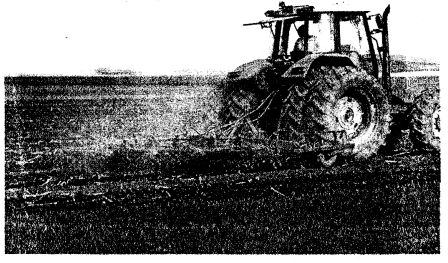
ICSE Solutions for Class 6 Geography Voyage Chapter 6 Major Crops 4
The photograph here shows an important feature of an agricultural movement.

Question 1.
Identify the agricultural movement.
Answer:
This picture shows the Green Revolution which came to India in 1960‘s under the supervision of Dr. Norman Borlaug.

Question 2.
Who supervised this movement in India ?
Answer:
The Indian government encouraged fanners to grow new dwarf and semi-dwarf varieties of seed particularly of wheat in the plains of Punjab and Haryana.

Question 3.
List any four demerits of this movement.
Answer:
The main demerits of this revolution were.

  1. It leads to over dependence on fertilizers and pesticides.
  2. Unemployment, as new machinery replaced manual labour.
  3. It was confined to rich farmers as the cost of fertilizers, hybrid „ seeds, pesticides was high.
  4. The farm water polluted with fertilizers and pesticides is affecting human health.

ICSE Solutions for Class 6 Geography Voyage – Major Water Bodies

ICSE Solutions for Class 6 Geography Voyage – Major Water Bodies

ICSE SolutionsSelina ICSE SolutionsML Aggarwal Solutions

APlusTopper.com provides step by step solutions for ICSE Solutions for Class 6 Geography Voyage. You can download the Voyage Geography ICSE Solutions for Class 6 with Free PDF download option. Geography Voyage for Class 6 ICSE Solutions all questions are solved and explained by expert teachers as per ICSE board guidelines.

ICSE Solutions Class 6 GeographyHistory & CivicsBiologyChemistryPhysicsMaths

POINTS TO REMEMBER

  • Nearly 71 per cent of the surface of earth is covered by water.
  • There are five large water bodies called oceans in the world. These are the Pacific Ocean, the Atlantic Ocean, the Indian Ocean, the Arctic Ocean and the Southern Ocean. Smaller water bodies include seas, lakes and rivers.
  • A river is a stream of water which flows in a channel from high ground to low ground and finally to a lake or a sea. The place where the river originates is called its source and the place where it ends is called its mouth.
  • The route or course of a river has three stages—the upper, middle and lower stages. In the upper stage the river is in the mountains, in the middle stage it flows over plains, and in the lower stage the river generally meets an ocean or a sea.
  • Almost all human activities generate waste which causes pollution.
  • Untreated liquid waste from kitchens and toilets of households, liquid wastes from thermal power plants, surface run-off from farms and oil spills are the main causes of water pollution.
  • Water pollution causes diseases such as typhoid,cholera and amoebic dysentery.

IMPORTANT TERMS

Ridge : A high pointed area near the top of a mountain.
Surface run-off : Water from rain, melting snow, or other sources that flows over land and is a part of the water cycle.

THINK AND ANSWER

Everything that we do creates waste, which, in turn, creates pollution. How do you think you can reduce the amount of waste you generate ?
Answer:

  1. Liquid waste from thermal power plants should not be discharged in the rivers. As It increases the dissolved oxygen content of river water,leading to a sudden rise in microbe population. This, in turn, reduces the level of oxygen in the river and makes it difficult for other kinds of organisms to survive.
  2. Surface run-off should not be discharged in the rivers as
    Surface run-off from farms carries organic and inorganic fertilizers into water bodies. This promotes the growth of algae, which reduces the dissolved oxygen level in water. Other living organisms in water bodies, including fish, cannot survive in such conditions.
  3. By not discharging the Untreated liquid waste into the rivers. Untreated liquid waste from kitchens and toilets is often discharged into rivers. This exposes people who use river water to diseases such as typhoid, cholera and amoebic dysentery.
  4. By taking dual care of leakage of Oil Spills in rivers. An oil spill occurs when crude oil, while being transported from one country to another, gets leaked into the sea.

VALUES AND LIFE SKILLS

Water is very important for sustaining life on earth. We should be careful while using water and should take steps to save our water resources.
What are the things that you can do to save water ?
Answer:
We can save water by doing following things,

  1. Check all faucets, pipes and toilets for leaks.
  2. Install water saving showerheads and ultra-low-flush toilets.
  3. Take shorter showers.
  4. Never use your toilet as a wastebasket.
  5. Turnoff the water while brushing your teeth or shaving.

EXERCISES

A. Match the columns
ICSE Solutions for Class 6 Geography Voyage Chapter 4 Major Water Bodies 1
Answer:
ICSE Solutions for Class 6 Geography Voyage Chapter 4 Major Water Bodies 2

B. With the help of your atlas identify and mark the following in an outline map of the world.

Question 1.
The largest ocean in the world
Answer:
Pacific ocean.

Question 2.
The northernmost ocean
Answer:
Arctic ocean.

Question 3.
An inland sea in Eurasia
Answer:
Aral sea.

Question 4.
Two rivers in Europe
Answer:
Rhine and Danube.

c. Answer the following questions in brief

Question 1.
Name the major water bodies on earth.
Answer:
The major water bodies on earth are oceans, seas, lakes and rivers.

Question 2.
What is the Ring of Fire ?
Answer:
The pacific ocean is bordered by volcanic mountains on its edges. So it is termed as ‘Ring of Fire’.

Question 3.
What is the difference between a gulf and a bay ?
Answer:
A gulf is an inlet of the sea of large areal proportions while a bay is an open, curving indentation made by the sea or a lake into a coastline. Gulfs are more indented than bays and also more enclosed.

Question 4.
What do you understand by strait ? Give an example.
Answer:
A strait is a narrow stretch of water that joins two large water bodies. The Strait of Gibraltar, for example, connects the Mediterranean Sea to the North Atlantic Ocean.

Question 5.
Mention the five Great Lakes of the USA.
Answer:
The five Great Lakes of the USA — Superior, Huron, Michigan, Ontario and Erie—are a group of five huge freshwater lakes located between the United States and Canada. They comprise the largest body of fresh water on earth.

Question 6.
Name the different parts of a river.
Answer:
The two main parts of a river are its source (from where the river originates) and the mouth (where the river enters the sea).

Question 7.
What is surface run-off ?
Answer:
Surface run-off means the water from any source i.e. rain, river, etc which carries away the upper layer of soil, organic and inorganic fertilizers and make it a part of water cycle.

D. Answer the following questions in one or two paragraphs

Question 1.
Why are oceans important ?
Answer:
Oceans are very important for us for many reasons :

  1. Oceans are great storehouses of oil and mineral resources.
  2. They support a large variety of aquatic life.
  3. They facilitate international trade by providing trade routes.
  4. Oceans are also a source of food supply for many people around the world.

Question 2.
Describe the course of a river.
Answer:
The river passes through three courses from its source to mouth – upper, middle and lower. The upper course generally lies in mountains where land is steep and river flows very fast. At middle course the river speed decreases as plains have gentle slope. The flow of the river is nearly halted at its mouth (where it meets the sea or ocean).

Question 3.
Mention any five important rivers of the world,
Answer:
The river Nile in Africa, 6,695 km in length, is the world’s longest river. It flows out into the Mediterranean Sea. The Amazon, 6,640 km in length, flows through South America and is the second longest river in the world. Other important rivers in the world are the Mississippi in the USA, the Rhine and the Danube
in Europe and the Ganga in India.

Question 4.
Briefly describe the importance of rivers.
Answer:
Importance of Rivers — Rivers are an extremely important water resource:

  1. The river valleys and plains provide fertile soils and crops grow in plenty in and around the region,
  2. River water is used for human and animal consumption. Rivers provide abundant water supply to support large settlements.
  3. Rivers provide means of transport to carry humans and goods from one place to another and thus facilitate trade.
  4. River water is an important source of energy. It is used to power hydroelectric plants and helps in generation of electricity. It also thus helps the industries to grow.
  5. Rivers also provide the means for recreational activities.

Question 5.
What are the major causes of water pollution ?
Answer:
The major causes of water pollution are liquid waste from thermal power plants, surface run-off, untreated liquid waste from industries, sewage, household waste and oil-spills.

Question 6.
What is an oil spill ? Why is it harmful for the environment ?
Answer:
When the crude oil gets leaked into the sea while being transported from one country to another because of an accident and hurricanes it is called oil – spill. The aquatic life gets poisoned as oxygen can’t reach them and leads to their death affecting the life cycle.

E. Picture study:
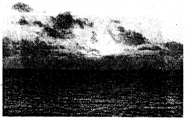
ICSE Solutions for Class 6 Geography Voyage Chapter 4 Major Water Bodies 3
Look at the picture of an ocean given here and answer the questions.

Question 1.
Describe the characteristics of the largest ocean in the world.
Answer:
Pacific ocean is the largest ocean and covers one-third of the globe. It is circular in shape and is bordered by volcanic mountains and is termed as ‘Ring of Fire’. The deepest part of earth i.e. Mariana Trench lies in this ocean near the Philippines.

Question 2.
What are the differences between an ocean and a sea ?
Answer:
Ocean :

  1. Oceans are large water bodies covering 97% of earth’s water.
  2. There are main 5 oceans eg. Pacific, Arctic, Atlantic, Indian and Southern Ocean.

Sea :

  1. Sea is a part of the ocean that is smaller and shallower, located close to the edge of a land mass or continent.
  2. There are many seas eg. Caribbean sea, Bering sea, Arabian sea, North sea, etc.

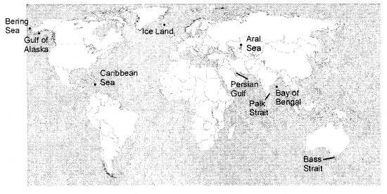
F. On a blank outline map of the world, mark and label the following.
Gulf of Alaska, Caribbean Sea, palk Strait, Bay of Bengal, Bering Sea, Perisan Gulf, Bass Strait, Iceland, Aral Sea
Answer:
ICSE Solutions for Class 6 Geography Voyage Chapter 4 Major Water Bodies 4

Let’s Do Something

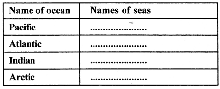
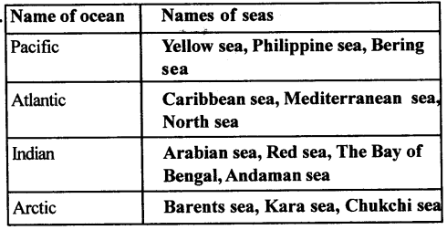
Question 1.
Refer to your atlas and identify some of the important seas in each ocean. Tabulate your observations as shown here and then mark and label them on a blank outline map of the world.
ICSE Solutions for Class 6 Geography Voyage Chapter 4 Major Water Bodies 5
Answer:
ICSE Solutions for Class 6 Geography Voyage Chapter 4 Major Water Bodies 6

ICSE Solutions for Class 6 Geography Voyage – Types of Agriculture

ICSE Solutions for Class 6 Geography Voyage – Types of Agriculture

ICSE SolutionsSelina ICSE SolutionsML Aggarwal Solutions

APlusTopper.com provides step by step solutions for ICSE Solutions for Class 6 Geography Voyage. You can download the Voyage Geography ICSE Solutions for Class 6 with Free PDF download option. Geography Voyage for Class 6 ICSE Solutions all questions are solved and explained by expert teachers as per ICSE board guidelines.

ICSE Solutions Class 6 GeographyHistory & CivicsBiologyChemistryPhysicsMaths

POINTS TO REMEMBER

  • Agriculture refers to the cultivation of land.
  • Subsistence farming is practised by poor farmers who own small pieces of land.
  • Intensive farming is practised on small plots of land.
  • Extensive farming is practised in areas of low population and where of land is available for cultivation.
  • Shifting cultivation is practised mainly by tribal people in some primitive and densely forested regions of the world.
  • In commercial forming, crops are grown on a large scale, mainly for selling the produce in the market—both at home and abroad.
  • Plantation farming is a type of commercial farming. Here, a single crop, instead of multiple crops, is planted over a large area known as a plantation.

IMPORTANT TERMS

Agriculture : Cultivation of a field.
Combine harvester : a large farm machine which cuts a crop and separates the grain from the rest of the plant.
Commercial : Connected with the buying and selling of goods and services.
Machete : A broad, heavy knife used as a cutting tool or a weapon.
Subsistence : The state of having just enough money or food to stay alive.
Yield : The total amount of crops produced.

THINK AND ANSWER

Why do you think commercial farming is practised in countries like the USA and Australia ?
Answer:
Both USA and Australia are developed countries having large farms and more money to invest in large machinery, hybrid crops, fertilizers and pesticides. The machineries allow the farmers to cultivate grains like wheat, maize, barley etc. on a large scale.

VALUES AND LITE SKILL

Farmers put in a lot of hard work and money in producing crops. We should remember this and not waste food.
What should you do if you do not like a dish that is served in the school canteen ?
Answer:
We should not throw the food even if we don’t like it’s taste. We shall keep the dish on the wall for birds or animals to eat.

EXERCISES

A. Fill in the blanks

  1. Food grains are the most important products that come from agriculture.
  2. Farmers who practise subsistence farming depend on the monsoon rains for water for the crops.
  3. Intensive farming requires a lot of labour on a small piece of land.
  4. Extensive farming is practised in areas of low population.
  5. Shifting cultivation is generally practised in forested areas.

B. Match the columns

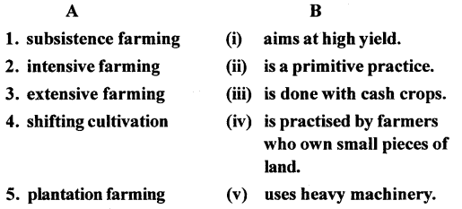
ICSE Solutions for Class 6 Geography Voyage Chapter 5 Types of Agriculture 1
Answer:
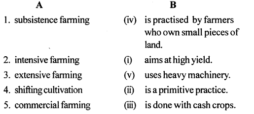
ICSE Solutions for Class 6 Geography Voyage Chapter 5 Types of Agriculture 2

C. State whether the following are true or false 

1. Agriculture is not an important occupation anymore.
Answer. False.
Correct — Agriculture is an important occupation anymore.

2. Farmers who practise subsistence farming use modern methods of irrigation.
Answer. False.
Correct— Farmers who practise subsistence fanning use old methods of irrigation or depend on the monsoon rains.

3. Intensive farming requires very little labour to work on the farm.
Answer. False.
Correct— Extensive farming requires little labour to work on the farm.

4. Extensive farming is practised in countries like India, China and Japan.
Answer. False.
Correct— Intensive farming is practised in countries like India, China and Japan.

5. Shifting agriculture is wasteful and harmful to forests and wildlife.
Answer. True.

D. Answer the following questions in brief

Question 1.
What do you understand by agriculture ?
Answer:
Agriculture means cultivation of a field. It includes growing of crops, rearing animals for dairy and meat products, poultry farming and rearing fish in ponds.

Question 2.
Name any three types of agriculture practised around the world.
Answer:
The various types of agriculture practised around the world include subsistence farming, intensive farming and extensive farming.

Question 3.
Define subsistence agriculture.
Answer:
Subsistence farming is growing crops to meet the farmers own needs. The land is small and organic or natural fertilizers like cow dung, dried plants, etc. are used. It depends on monsoon rains for watering of crops.

Question 4.
Why is intensive farming expensive ?
Answer:
Intensive farming is expensive as the farmer tries to get maximum field from his small land using hybrid seeds, fertilizers, pesticides, etc.

Question 5.
Name the crops grown by extensive farming.
Answer:
The main crops grown in extensive farming are wheat, maize and barley.

Question 6.
Why is shifting cultivation not productive in the long run?
Answer:
This form of agriculture is wasteful and harmful to forests and wildlife. After a few years the fertility of the land is reduced. The infertility is caused by excessive leaching, a process in which the salts and minerals of the soil are drained away by water.

Question 7.
In which parts of India is shifting cultivation practised ?
Answer:
In India, this practice is prevalent in states such as Arunachal Pradesh, Nagaland, Manipur and Mizoram in the north-east and in Chhattisgarh and Jharkhand. It is also practised in the Andaman and Nicobar Islands.

Question 8.
Mention any two features of commercial farming.
Answer:
In commercial farming, crops are grown on a large scale, mainly for selling the produce in the market-both at home and abroad. The main aim of this type of farming is to earn profit. The farms may or may not be very large. Modem methods of cultivation such as using high yielding variety of seeds, chemical fertilizers, and pesticides are used along with modem irrigation techniques and cold storage to store the produce after harvest.

E. Answer the following questions in one or two paragraphs

Question 1.
Briefly explain subsistence agriculture.
Answer:
Subsistence farming is practised by farmers who own small pieces of land. Such farmers grow just enough crops to meet their needs and those of their families. They generally grow rice or vegetables and use organic or natural fertilizers such as cow dung, animal droppings and dead and dried plants. They depend on the monsoon rains for water for the crops.

Question 2.
Distinguish between intensive and extensive farming.
Answer:
Intensive farming :

  • Land is small.
  • More labour is employed
  • Expensive farming as more fertilizers, hybrid seeds, pesticides, etc. are used.

Extensive farming :

  • Plenty of land.
  • Less labour is employed work is done by large machines like combine harvesters, etc.
  • Low cost farming. Mostly cereal crops are grown.

Question 3.
What do you understand by shifting agriculture ?
Answer:
Shifting agriculture is mainly practised by tribal people who clear a small area in the forests, scatter the seeds, leaves them to grow, depend on monsoon for water and when the land becomes infertile after some years shift themselves to a new piece of land in the forests.

Question 4.
What crops are grown by commercial farming ? What are the methods that are employed ?
Answer:
The main crops grown on commercial scale are apples, grapes, mushrooms, cauliflower, broccoli, etc. These crops are mainly grown to earn profit. Modern methods of cultivation such as hybrid seeds, chemical fertilizers, pesticides, modem irrigation techniques and cold storage to store the produce after harvest are used.

Question 5.
Write a short note on plantation farming.
Answer:
Plantation farming is a kind of cofhmercial farming in which a single crop is grown instead of multiple crops. These crops include tea, coffee, rubber, cocoa, coconut, sugarcane, cotton, etc.

Question 6.
Write a short note on mixed farming.
Answer:
Mixed farming is a form of farming in which crops are grown and animals are reared on the same farmland. Farmers grow a variety of crops and also keep a number of dairy animals to get milk. Sometimes poultry is also kept. Farmers practise mixed farming mainly with a view to increasing their earnings, from two different sources. One of the major benefits of mixed farming is that if one form of farming enterprise fails, the farmer could still depend on the other. Modem machinery and tools, selected high quality seeds, chemical fertilizers in large quantities and other highly advanced techniques of farming are used. The natural manure provided by the animals helps in minimizing soil erosion, rotation of crops and conservation of water. Mixed farming makes good use of crop residue which, if not used as animal feed, can be used as fertilizers in the soil.

F. Picture study
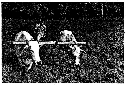
ICSE Solutions for Class 6 Geography Voyage Chapter 5 Types of Agriculture 3

The photograph here shows a farmer tending to his field.

Question 1.
What type of farming is he practising ?
Answer:
The farmer is practising subsistence farming i.e. growing crops to meet his own daily needs.

Question 2.
What are the difficulties that he might face ?
Answer:
He might not get good yield because of poor seed quality, bad monsoon and lack of fertilizers and pesticides.