ICSE Solutions for Class 7 Geography Voyage – Renewable and Non-renewable resources

ICSE Solutions for Class 7 Geography Voyage – Renewable and Non-renewable resources

ICSE SolutionsSelina ICSE SolutionsML Aggarwal Solutions

APlusTopper.com provides step by step solutions for ICSE Solutions for Class 7 Geography Voyage. You can download the Voyage Geography ICSE Solutions for Class 7 with Free PDF download option. Geography Voyage for Class 7 ICSE Solutions all questions are solved and explained by expert teachers as per ICSE board guidelines.

ICSE Solutions Class 7 Geography History & CivicsMathsPhysicsChemistryBiology

DISCUSS

Discuss the ways by which you can conserve energy, especially petroleum and electricity, in your homes and school. What changes do you need to make in your daily routine to save these precious resources ?
Answer:
I would preferably follow all the ways mentioned in the question to conserve energy.

  1. Careful use of petroleum and electricity : One should preferably use bicycle or barefoot for shorter distances instead of cars. One must switch off the switches when lights/fans are not required.
  2. Careful use of water when washing and gardening : One should properly utilise the water while washing clothes and gardening. Do not keep the taps open and waste water.

THINK AND ANSWER

Hydroelectricity is considered a good energy option for the future. Why ?
Answer:
Hydropower is fueled by water, so it’s a clean fuel source, meaning it won’t pollute the air like power plants that bum fossil fuels, such as coal or natural gas.
Hydroelectric power is a domestic source of energy, allowing each state to produce their own energy without being reliant on international fuel sources.
The energy generated through hydropower relies on the water cycle, which is driven by the sun, making it a renewable power source, making it a more reliable and affordable source than fossil fuels that are rapidly being depleted.

VALUE AND LIFE SKILL

Electricity is very important for all of us. We need it for our homes, offices, industries and agriculture.
Make a list of five different ways in which you can save electricity, for instance, switching off fans, ACs, light at home and in school when these thing are not required.
Answer:
The ways in which we can save electricity are :

  1. Using natural light whenever possible instead of using artificial light
  2. Replacing our bulb with CFL or LED bulbs.
  3. Turn off the lights wherever it is not required.
  4. By unpluging the appliances that are not in use.
  5. Replacing old appliances with new energy saving models.
  6. Using less air conditioner and less hot water.

EXERCISES

A. Fill in the blanks.

1. Sun, water, wind are examples of renewable energy resources.
2. Solar cells use the power supplied by the Sunlight.
3. Geothermal energy is the heat of the earth.
4. Coal, petroleum and natural gas are fossil fuels.
5. Anthracite is the coal with the highest percentage of coal.

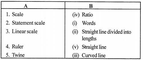
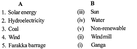
B. Match the following.
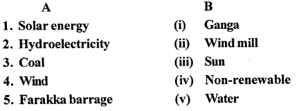
ICSE Solutions for Class 7 Geography Voyage Chapter 11 Renewable and Non-renewable resources 1
Answer:

ICSE Solutions for Class 7 Geography Voyage Chapter 11 Renewable and Non-renewable resources 2

C. Choose the correct answer.

1. Photovoltaic cells use the energy of

  1. sun
  2. wind
  3. water
  4. tides

2. Hydroelectricity is obtained by using

  1. wind
  2. water
  3. coal
  4. natural gas

3. Wind mills have been used for many centuries in

  1. the USA
  2. the Netherlands
  3. Russia
  4. India

4. The coal that has the highest percentage of carbon is

  1. anthracite
  2. bituminous
  3. lignite
  4. peat

5. The Bhakra-Nangal Dam is situated on the river

  1. Yamuna
  2. Beas
  3. Ravi
  4. Satluj

D. State whether the following is True or False.

1. Coal and petroleum are renewable energy resources.
Answer. False.
Correct : Coal and petroleum are non-renewable energy resources.

2. Renewable energy resources have limited supply in nature.
Answer. False.
Correct : Renewable energy resources have unlimited supply in nature.

3. China, USAand Spain are major producers ofwind energy.
Answer. True.

4. Coal takes millions of years to form.
Answer. True.

5. The Sardar Sarovar Dam is built on the river Narmada.
Answer. True.

E. Answer the following questions brief.

Question 1.
What are renewable energy resources?
Answer:
Renewable energy resources are those that come from natural sources and are naturally replenished. These include solar energy (sunlight), wind energy from windmill (wind), hydroelectricity (rain), tidal energy from waves (tides) and geothermal energy (energy from the heat of the earth).

Question 2.
What is the main difference between renewable an non-renewable energy resources?
Answer:
Renewable Resources

  1. These are those resources which can be renewed in a short time.
  2. These do not cause any pollution to the environment.
  3. These are the free gifts of nature.
  4. Air, water and solar energy are the examples of renewable resources.

Non-Renewable Resources

  1. These are those resources which cannot be renewed in a short time.
  2. These cause pollution to the environment.
  3. These are not the free gifts of nature.
  4. Coal, Petroleum and some minerals are the examples of the non-renewable resources.

Question 3.
What is tidal energy ?
Answer:
Tidal energy is an inexhaustible source of energy. It is energy generated from ocean tides. High tides in coastal areas are used to generate power. Tidal energy is generated free of cost.

Question 4.
Which countries are major producers of wind power in the world?
Answer:
China, USA, Germany, Spain and Netherland are the leading wind power producing nations.

Question 5.
What is biogas ? How is it useful to us ?
Answer:
Animal waste and all other kinds of organic waste material generated by households each day converted into biogas. This gas is an excellent source of cheap power for small-scale usage.

Question 6.
What are fossil fuels?
Answer:
Fuels formed in the geological past from the remains of living organisms and plants etc. Examples of fossil fuels are coal, petroleum and natural gas, etc.

Question 7.
Name a few major producers of petroleum in the world.
Answer:
The main oil-producing areas are the Gulf countries including Saudi Arabia, Iraq, Iran, USA, Venezuela, Algeria and Russia.

F. Answer the following questions in one or two paragraph.

Question 1.
Give an account of the use of solar energy.
Answer:
Solar energy is the energy that we receive from the sun. It is readily available in nature and in unlimited quantities.
While there are several ways to obtain solar energy, one way is by the use of solar cells or photovoltaic panels. These panels are made from very thin semi-conducting materials which, when exposed to sunlight, use the heat and light of the sun to shake the electrons loose and create an electric current.
Solar cells are used for lighting street lamps, in electronic calculators, watches, smart phones, camera, traffic signals, water pumps and home lighting. Solar energy is being used to heat ovens, cook food and heat water.

Question 2.
How is hydroelectricity generated?
Answer:
The word ‘hydro’ means water and hydroelectricity is the energy obtained using water. It is produced when water falls from a height under the force of gravity. The falling water then turns the wheels of a large turbine that generate electricity.

Question 3.
Explain briefly geothermal energy.
Answer:
Geothermal energy is the energy generated by harnessing the heat in the interiors of the earth. The earth has very hot materials below the crust. They heat up groundwater to produce hot water and steam. This hot water and steam gush up in many places as springs and geysers, which may be used to run turbines to generate electricity.

Question 4.
What do you know about wind energy?
Answer:
Wind is used to produce electricity. When the wind blows, it turns the three large blades of the windmill which are attached to the turbine. The turbine, which is connected to the generator converts the energy of the wind into electrical energy.
Wind, like the sun, is nature’s gift to the earth. It is free and widely available.

Question 5.
Describe the four major types of coal.
Answer:
Depending on the carbon content, there are four types of coal: Arundeep’s Self-Help to Voyage-7

(a) Anthracite is the best quality coal since it has almost 90% carbon.
(b) Bituminous coal is the second-best coal with 65% to 70% carbon.
(c) Lignite is a poor quality coal with a carbon content of around 60%.
(d) Peat has very little carbon, is not fully formed and gives little heat and a lot of smoke on burning.

Question 6.
Write a short note on nuclear power.
Answer:
Nuclear power is also known as atomic energy. The disintegration of radioactive elements such as uranium and thorium releases nuclear power. Nuclear power is the energy obtained either through fusion or fission.

Question 7.
Write about hydroelectric projects in India.
Answer:
India ranks fourth in terms of number of dams. India has more than 4800 completed large dams and many more are being built. Some important dams in India are:

  • Bhakra-Nangal dam — on river Satluj.
  • Damodar Valley Project — on river Damodar in West Bengal
  • Farakka Barrage — on river Ganga in West Bengal,
  • Sardar Sarovar dam — on Narmada,
  • Hirakuddam — onMahanadi.
  • Nagarjuna Sagar and Idukki dams — on Krishna
  • Idukki dam — on Periyar in Kerala.

Question 8.
Why do we need to conserve our energy resources ?
Answer:
Conservation of energy is important, especially the conservation
of conventional energy resources that may get exhausted in this century itself. With growing demands due to increasing population, we are overusing and wasting them. It is important that we soon find ways to use non-conventional sources of power as there is no danger of them being exhausted in our lifetime. In our daily life, we need to conserve energy. By remembering the 3 R’s and practising reuse, recycle, and reduce,
we can save a lot of resources, utilize them judiciously, and conserve them for future generations.
It should be realized that if all life-supporting resources are indiscriminately used then our very existence on earth would be in danger.
Car pooling, turning off lights and fans when not required, cycling and using public transport are effective ways of saving energy. Alternative sources of energy, such as the sun, wind and water, must be extensively used.

G. Large – scale hydroelectric projects have an impact on the environment. Search the Internet to find out how these projects affect the flora and fauna, and people’s lives in the area.
Answer:
Do it yourself.

H. Picture Study
Look at the picture and answer the following questions.
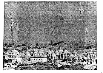
ICSE Solutions for Class 7 Geography Voyage Chapter 11 Renewable and Non-renewable resources 3

Question 1.
What type of energy is generated at this site?
Answer:
Wind Energy.

Question 2.
Where is this type of energy generated in India?
Answer:
India has several wind forms especially in the South.
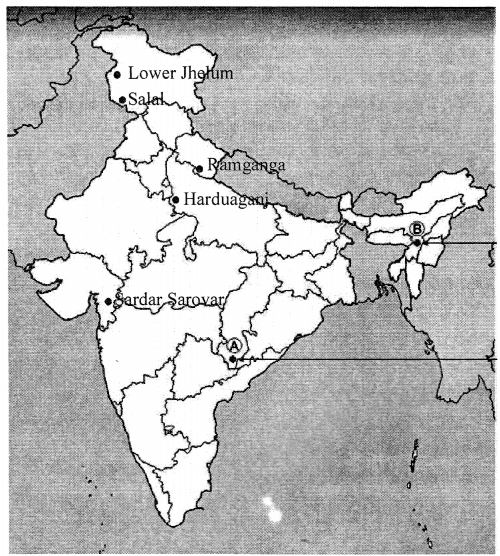
I. Map work.
On the outline map of India given here, mark and name any five hydroelectric projects in India.
Answer:
The five hydroelectric projects in India are :

  1. Lower Jhelum
  2. Salal
  3. Ramganga
  4. Harduaganj
  5. Sardar Sarovar

ICSE Solutions for Class 7 Geography Voyage Chapter 11 Renewable and Non-renewable resources 4

LET’S DO SOMETHING

Where does your water come from ?
Each city has a different source for its water supply like reservoirs, rivers or wells. Find out where your town or city gets its supply of water from.
Answer:
I live in Jalandhar City, Punjab and Jalandhar Water come from ‘The Bist Doab Canal System
Note for Students: Please check the source of water of your city and write that.


ICSE Solutions for Class 7 Geography Voyage – Scale and Distance

ICSE Solutions for Class 7 Geography Voyage – Scale and Distance

ICSE SolutionsSelina ICSE SolutionsML Aggarwal Solutions

APlusTopper.com provides step by step solutions for ICSE Solutions for Class 7 Geography Voyage. You can download the Voyage Geography ICSE Solutions for Class 7 with Free PDF download option. Geography Voyage for Class 7 ICSE Solutions all questions are solved and explained by expert teachers as per ICSE board guidelines.

ICSE Solutions Class 7 Geography History & CivicsMathsPhysicsChemistryBiology

THINK AND ANSWER

Question
Why do you think that the knowledge of scale is important for reading a map ?
Answer:
The two cities in the space of an inch will be found on a map where the scale is used. e.g. 1 cm on map =100 km on ground. Scales are important as without scales distance between places can’t be judged.

VALUES AND LIFE SKILLS

Question
Your friend has invited you to his house. He has drawn a rough sketch on a paper showing the direction to his house for you.
How does the sketch help you ? What quality of your friend is shown through in this gesture ?
Answer:
Sketch will help to reach friend’s house easily and early.
A friend is showing a genuine interest and is real. He actually wants a friend to visit his house.

EXERCISES

A. Fill in the blanks. one has been done for u

ICSE Solutions for Class 7 Geography Voyage Chapter 2 Scale and Distance 1

B. Match the following

ICSE Solutions for Class 7 Geography Voyage Chapter 2 Scale and Distance 2

Answer:

ICSE Solutions for Class 7 Geography Voyage Chapter 2 Scale and Distance 3


C. Choose the correct answer.

1. This is the ratio of distance between two places on a map to the actual distance between the same two places on the ground.

  1. scale
  2. map
  3. globe
  4. atlas

2. This scale is stated in words:

  1. Verbal
  2. Statement
  3. Both of these
  4. None of these

3. The distance between two points along a straight line can be measured by this method

  1. Twine
  2. Ruler
  3. Compass
  4. Stick

4. In this fraction, the numerator is always 1.

  1. Representative Fraction
  2. Refractive Fraction
  3. Reduction Fraction
  4. Reorganization Fraction

D. State whether the following are true or false.

1. Verbal scale is stated in words.
Answer. True.

2. A statement scale consists of a straight line which is divided into lengths.
Answer. False.
Correct : A linear consists of a straight line which is divided into lengths.

3. The numerator in a Representative Fraction expresses the actual distance between two places on the ground.
Answer. False.
Correct : The denominator in a Representative Fraction expresses the actual distance between two places on the ground.

4. The distance along a curved line is measured by a ruler.
Answer. False.
Correct : The Distance along a curved line is measured by a divider.

E. Answer the following questions briefly

Question 1.
What is meant by the scale of a map ?
Answer:
A scale is the ratio of the distance between two places on the map to the actual distance between the same two places on the ground.

Question 2.
Which three ways are used to represent the scale of a map?
Answer:
The three ways used to represent the scale of a map are :

(a) Verbal or statement scale — The scale is stated in words. The units are usually mentioned in this type of scale, for example, 1 cm = 10 km or 1 cm to 10 km. It means that 1 cm on the map is equal to 10 km on the ground.
(b) Graphical or linear scale — This consists of a straight line which is divided into lengths that represent given distances on the earth’s surface.
(c) Representative fraction (RF) — This is a fraction in which the numerator expresses the distance on the map and the denominator represents the actual distance on the ground. It must be noted that the numerator is always 1 and both the numerator and the denominator are expressed in the same unit.

Question 3.
Convert the statement scale 1 cm = loo km into R.F. scale.
Answer:
ICSE Solutions for Class 7 Geography Voyage Chapter 2 Scale and Distance 4

Question 4.
What method would you use to measure the length of a river ?
Answer:
The rivers are curved. To measure length of rivers we use either the divider method or the twine methods.

F. Answer the following questions in detail.

Question 1.
Describe any two ways of representing a map scale.
Answer:
The map scale can be represented as :

(a) Verbal or statement scale — The scale is stated in words. The units are usually mentioned in this type of scale, for example, 1 cm= 10 km or 1 cm to 10 km. It means that 1 cm on the map is equal to 10 km on the ground.
(b) Graphical or linear scale — This consists of a straight line which is divided into lengths that represent given distances on the earth’s surface.

Question 2.
Describe the method by which the distance on a curved line is measured.
Answer:
The distance on a curved line is measured using a piece of twine or a divider.
In divider method, a divider whose pointed ends are 1 or 2 cm apart is used. Beginning at one end of the feature to be measured, the divider is turned continuously till the other end is reached. The number of turns are counted and then using the scale of the map, the actual distance on the ground calculated.
In the twine method, a twine is placed along the feature to be measured from one end to other. The length of the twine is then measured in cm or inches using a ruler or linear scale and then converted into km or miles using the scale of the given map.

Question 3.
How is distance on a map measured by a piece of twine?
Answer:
Take the piece of the twine, make a knot at one end and place
the knotted end on the starting point of the distance to .be measured. Now move the twine along the object to be measured by slowly placing the twine bit by bit along the route following each bend or curve as closely as possible. When you reach the end of the route you are measuring, mark that end with ink. Now place the twine on the scale with the knotted end at 0 and see how far the ink-marked end reaches on the scale. Measure the length and convert into kilometres. If the distance to be measured is longer than the printed scale on the map, place the twine on the ruler in the same way, calculate the number of centimetres it covers and convert that into kilometres.

G Picture study
Look at the picture and answer the questions
ICSE Solutions for Class 7 Geography Voyage Chapter 2 Scale and Distance 5

Question 1.
What type of scale is shown alongside ?
Answer:
A graphic scale or linear scale.

Question 2.
State a feature of this scale.
Answer:
This consists of a straight line which is divided into lengths that represent given distances on the earth’s surface. It is usually drawn near the lower portion of the map.

LET’S DO SOMETHING

Question
Look at the plan of a school given here and note the scale given at the top of the plan : 1 cm to 8 m. This verbal scale means that 1 cm on the paper represents 8 m on the ground. Use this scale to find out the length and breadth of the different places shown in the plan.
Answer:
The length and breadth of different places is as follows:
(a) Playground
Length of the playground = 3.5 cm = 3.5 × 8 m = 27 m
Breadth of the playground = 4 cm = 4 × 8 m = 32 m
(b) Office
Length of the office = 1.1 cm- 1.1 × 8 m = 8.8 m
Breadth of the office = 0.8 cm = 0.8 × 8 m = 6.4 m
(c) Library
Length of the library = 1.1 cm= 1.1 × 8 m = 8.8 m
Breadth of the library = 0.8 cm = 0.8 × 8 m = 6.4 m
(d) Classroom
Length of the Classroom = 4.35 cm = 4.35 × 8 m = 34.8 m
Breadth of the Classroom = 2.1 cm = 2.1 × 8 m = 16.2 m
(e) Tennis Court
Length of the Tennis Court = 1.7 cm= 1.7 × 8 m = 13.6 m
Breadth of the Tennis Court = 2.7 cm = 2.7 × 8 m = 21.6 m
(f) Gym
Length of the Gym = 1.5 cm= 1.5 × 8 m= 12 m
Breadth of the Gym = 1.7 cm = 1.7 × 8 m= 13.6 m
(g) Canteen
Length of the Canteen =1.5 cm=1.5 × 8m=12 m
Breadth of the Canteen = 1.75 cm = 1.75 × 8 m = 14 m


ICSE Solutions for Class 7 Geography Voyage – Europe : Location, Area, Political & Physical Features

ICSE Solutions for Class 7 Geography Voyage – Europe : Location, Area, Political & Physical Features

ICSE SolutionsSelina ICSE SolutionsML Aggarwal Solutions

APlusTopper.com provides step by step solutions for ICSE Solutions for Class 7 Geography Voyage. You can download the Voyage Geography ICSE Solutions for Class 7 with Free PDF download option. Geography Voyage for Class 7 ICSE Solutions all questions are solved and explained by expert teachers as per ICSE board guidelines.

ICSE Solutions Class 7 Geography History & CivicsMathsPhysicsChemistryBiology

THINK AND ANSWER

Why doesn’t Europe have a cold climate more similar to that of Alaska and northern Canada though it lies on the same latitudes ?
Answer:
It is because most of Europe has advantage of warm ocean currents coming north from tropics. There is little interaction with colder air masses and colder ocean currents so overall. Europe remains warmer than Alaska and Northern Canada.

VALUES AND LIFE SKILLS

Switzerland is one of the major tourist attractions. The Swiss government has taken many steps to make the country attractive for tourists from all over the world. The people also help to keep the country clean and secure.
What does it tell us about the Swiss people ?
What can you learn from them ?
Answer:

  1. Switzerland is one of the major tourist attractions. People residing in the Swtizerland are brilliant as they are taking advantage of the god gifts which are in the form of scenic beauty. They are smart enough to make money out of these scenic places. They keep their places neat and clean.
  2. We can leam many moral values from the people of Switzerland. They keep their place cities neat and clean. They are smart enough to make money by attracting touristers.
    However, one should keep their place neat and clean and always take out the full oppurtunity whenever we can.

EXERCISES

A. Give geographical reasons

Question 1.
Europe is rightly called the ‘peninsula of peninsulas’.
Answer:
Europe is called ‘Peninula of Peninsulas’ as whole Europe containing 50 countries juts out westward from Euraisa and surrounded by Arctic Ocean in North Atlantic in West and Mediterranean Sea and Black Sea in South.

Question 2.
Belgium, the Netherlands, and Luxembourg are called the Low countries.
Answer:
Netherlands, and Luxembourg are called the Low countries because they lie in the low-lying plains in the west.

Question 3.
The Central European Plains are densely populated.
Answer:
As the lands are very fertile and good for agriculture, so it is most densely populated.

Question 4.
The Caspian Sea is a lake.
Answer:
The Caspian Sea is a lake as it is surrounded by land on all sides.

B. Give two examples from Europe for each of the following

  1. High peaks
  2. Long rivers
  3. Large freshwater lakes
  4. Young fold mountains
  5. Mediterranean countries

Answer:

  1. Mont Blanc (4,807 m), Mt. Elbrus (5,642 m)
  2. Volga, Danube, Rhine
  3. Lake Ladoga in Russia, Vanem, Vattern and Malaren in Sweden.
  4. The Alps, Sierra-Nevada.
  5. Spain and Portugal.

C. Answer the following questions in brief

Question 1.
What are the chief physical divisions of Europe?
Answer:
There are four main physical divisions of Europe. They are :

(a) The Northern Mountains.
(b) The Central European Plains.
(c) The Southern Plateaux and Highlands.
(d) The Alpine Mountain System.

Question 2.
Why are the Ural and Caucasus mountains important?
Answer:
The Ural Mountains in the east and the Caucasus Mountains in the south-east separate it from Asia.

Question 3.
Name four countries bordering the Mediterranean Sea. Also name the capitals of these countries.
Answer:
The countries bordering the Mediterranean Sea are Spain, Portugal, France and Italy.
The capital’s of these countries are :
Spain – Madrid
Portugal – Lisbon
France – Paris
Italy – Rome

Question 4.
Identify two countries that belong to each of the following groups and state why they are so called:

  1. Low countries
  2. Balkan states
  3. Scandinavian countries

Answer:

  1. Low countries — The countries that lie in the low-lying plains in the west – Belgium, the Netherlands and Luxembourg.
  2. Balkan States — The countries in the Balkan Peninsula — Greece, Albania, Macedonia, Romania, Bulgaria, Bosnia- Herzegovina, Slovenia, Croatia, Serbia, and Montenegro.
  3. Scandavian countries — the north European countries – Norway, Sweden, Finland, Denmark, and Iceland.

Question 5.
Name any four major important cities of Europe.
Answer:
Some important cities of Europe:

  1. London – is the capital of the United Kingdom, a major centre of international trade and a flourishing port.
  2. Paris – is the capital of France and an important centre of science, technology, culture, and art.
  3. Berlin – Berlin is the capital city of Germany and also its largest city. It is an important river port.
  4. Moscow – Moscow is the capital of Russia and is situated on a tributary of the Oka River which joins the river Volga.

Question 6.
What are fiords? How are they formed ?
Answer:
Fiords are narrow but deep inlets of water with steep sides that break and indent the coastline Scandinavian making it irregular. In the coastal regions, fiords have been formed because of the drowning of glacier valleys.

D. Answer the following questions in one or two paragraphs

Question 1.
Briefly describe the location of Europe in relation to the other continents. What special advantage has Europe enjoyed due to its location?
Answer:
Europe lies almost in the middle of the northern hemisphere with North America to its west beyond the Atlantic Ocean, Asia to its east and Africa to its south. It stretches from 35°N to 73°N and most of its lies within the temperate zone. Longitudinally, it stretches from 25° W to 65° E.

Question 2.
Write a short note on the capital city of Russia.
Answer:
Moscow – Moscow is the capital of Russia and is situated on atributary ofthe Oka River which joins the river Volga. The city has a dozen rail routes and the terminus of the Trans- Siberian Railway. Moscow is a great administrative centre as well as the centre of a large industrial region. Red Square is the heart of Moscow.
On one side ofthe Red Square are the colourful onion-domes of Saint Basil’s Cathedral erected by a Russian master architect in the 16th century. On the other side is the tomb of Lenin.’
Also located in Moscow is the Kremlin, an incredible complex which encloses the offices of the Russian Government, palaces, churches, and towers. There are over 100 museums in Moscow.

Question 3.
Describe the Northern Mountains of Europe.
Answer:
These old fold mountains in the north and north-west extend from Norway and Sweden to Scotland. They are made up of very hard crystalline rocks and were once very lofty and rugged. However, after facing the erosive action of glaciers for millions of years, they have been reduced to low hills with gentle slopes.
In the coastal regions, fiords have been formed because of the drowning of glacier valleys. Fiords are narrow but deep inlets of water with steep sides that break and indent the coastline, making it irregular.

Question 4.
Write a note on the Central European Plains.
Answer:
These plains are partly covered with glacial deposits and partly by alluvium deposited by the many big rivers such as the Don, the Dneiper, the Volga and the Ural. These plains are not absolutely flat but are rolling lands with hills. However, they are very fertile and good for agriculture. Some of the most densely populated parts of Europe lie in this region.

Question 5.
Describe briefly the major young fold mountains of Europe.
Answer:
The Alpine Mountain System consists of chains of young fold mountains that lie south of the above mentioned plateaux, from the Atlantic Coast in the west to the Caspian Sea in the east. They have high peaks, deep valleys and rugged slopes. They are made up of several parallel ranges. Earthquakes and volcanic eruptions are common here. The Alps is the most important mountain system which extends like an arc separating Italy from France and Switzerland. Mont Blanc (4,807 m) is the highest peak in the Alps. In the west are the Sierra Nevada in southern Spain and the Pyrenees, which form a natural boundary between Spain and France.

Question 6.
What is the significance of the many big and small rivers of Europe?
Answer:
There are many rivers that radiate out in different directions from the Alpine Mountain System in southern Europe. The rivers are navigable and are inter-connected by canals to form an efficient system of waterways. Thus, several big towns and cities have sprung up along the banks of these rivers. The rivers are important for industries too. Large rivers such as Volga, Danube and the Rhine flow through many countries and are considered ‘international rivers’.
There are many small rivers in Europe too. They are important for navigation in the countries through which they flow

E. In your atlas, locate the major and minor rivers flowing through Europe. Note the names of important cities/towns that have developed on the banks of these rivers. Then tabulate your observations in your notebook using the headings given here :

  1. Name of the river
  2. Countries through which it flows
  3. Important town/cities situated on its banks.

Answer:
The Volga, the Danube, the Rhine flow, the Don
ICSE Solutions for Class 7 Geography Voyage Chapter 12 Europe Location, Area, Political & Physical Features 1

ICSE Solutions for Class 7 Geography Voyage Chapter 12 Europe Location, Area, Political & Physical Features 2

F. The Scandinavian countries are generally considered to have a separate cultural identity. Form groups in your class and search the Internet to gather information on these countries and then hold a discussion under the following points.

  1. employment
  2. education
  3. law and order
  4. care for the aged

Answer:
Do it yourself.

G Map work:
On the outline map of Europe, use different colours to mark and label the following:

  1. Oceans—Arctic, Atlantic
  2. Seas—Mediterranean, Baltic, North Sea
  3. Straits—Dover, Gibraltar
  4. Plateau—Central Massif, Meseta
  5. Mountains—Alps, Pyrenees, Carpathians
  6. Rivers—Danube, Rhine, Volga
  7. Lakes—Ladoga, Onega, Vanern
  8. Capitals—Paris, Moscow, Berlin

Answer:
ICSE Solutions for Class 7 Geography Voyage Chapter 12 Europe Location, Area, Political & Physical Features 3

H. Picture Study:
The photograph shows the highest peak in Europe.

ICSE Solutions for Class 7 Geography Voyage Chapter 12 Europe Location, Area, Political & Physical Features 4

  1. Name the peak.
  2. Name the mountain range in which it lies.

Answer:

  1. Mt Elbru
  2. Caucasus Mountains.

LET’S DO SOMETHING

Refer to the physical map of Europe in your atlas. Moving in an anti-clockwise direction starting from the Arctic Ocean and the White Sea, observe and note down the names of all the surrounding water bodies such as seas, bays, gulfs, straits, etc. Then mark each of them on an outline map of Europe.
Answer:
ICSE Solutions for Class 7 Geography Voyage Chapter 12 Europe Location, Area, Political & Physical Features 5