ICSE Solutions for Class 9 Geography – Landforms of the Earth

ICSE Solutions for Class 9 Geography – Landforms of the Earth

ICSE SolutionsSelina ICSE SolutionsML Aggarwal Solutions

Exercises

I. Short answer questions.

Question 1.
What is meant by a landform ?
Answer:
A landform is a natural feature on the surface of the earth with a particular shape.

Question 2.
Why are the fold mountains called so ?
Answer:
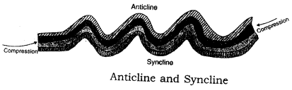
Fold mountains are called so because of the result of large- scale earth movements caused by stresses in the earth’s crust. Such stresses may be caused by weight of the overlying rocks, movements in the mantle, the expansion or contraction of some part of the earth, etc. These stresses subject the rocks to compressive forces, producing wrinkling or folding along the lines of weakness. This is shown in fig. the raising of folds makes the fold mountains.
ICSE Solutions for Class 9 Geography Chapter 5 Landforms of the Earth 1

Question 3.
Give two chief characteristics of the fold mountains.
Answer:

  1. The fold mountain system has parallel ranges.
  2. A fold mountain region is also a region of sudden forces such as of volcanoes and earthquakes.

Question 4.
Give one example of each :

(a) Young fold mountains;
(b) Old fold mountain. Why they are called so

Answer:

(a) These mountains are made of light sedimentary rocks of recent tertiary age and are the highest mountain system which are still increasing their heights due to gradual upthrust force. The Himalayas are called young fold mountains.
(b) The Alpine-Himalayan system and Circum Parific mountain belt are the ‘Old Fold Mountains’ which existed as geosynclines 50-60 million years ago.

Question 5.
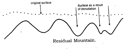
Give example of residual mountains.
Answer:
Examples of Residual mountains are Nilgiri, Parasnath and Rajmahal Hills in India and the Catskill range in the USA.

Question 6.
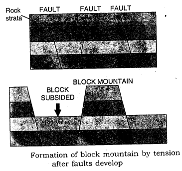
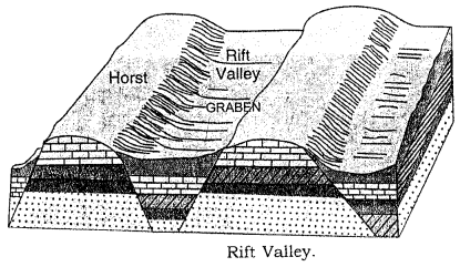
How is a rift valley formed ? Give one example of a rift valley.
Answer:
A rift valley is formed by the submergence of a big landmass between two high block mountains, e.g. the Rhine river flows through a rift valley in its middle course.

Question 7.
Give a brief definition of a plateau.
Answer:
The Himalayas are an important form of folding being the highest mountain range in the world.

Question 8.
Give one example of each :

(a) Intermontane plateau
(b) Volcanic plateau and
(c) Piedmont plateau

Answer:

(a) The Tibetan plateau
(b) The Plateau of Peninsular India.
(c) The Patagonian plateau of South America.

Question 9.
Give two points of importance of landforms.
Answer:
Various landforms display the internal and external forces of the earth, different climatic effects and features, forests, snow lands giving birth to rivers, coasts and islands as fishing regions. All these together make the earth beautiful and ideal for living and various activities.

Question 10.
What are known as epeirogenic movements ?
Answer:
The movements such as uplift and submergence working in vertical direction are known as epeirogenic movements. ‘Epeiros’ in Greek means continent ‘genic’ means building. As this movement created continents coming out higher from the oceans.

Question 11.
Name two landforms created by epeirogenic movements.
Answer:

  1. Block mountains.
  2. Rift valleys and basins are produced by epeirogenic movements.

Question 12.
Why are the sudden forces described as ‘Constructive forces ?
Answer:
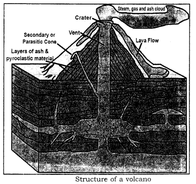
Earthquakes and volcanic activities are described as sudden forces. These forces are described as ‘Constructive Forces’ because they create relief features on the surface of the earth. As volcanic erruptions result in the formation of volcanic mountains, extensive plateaus and also plains.

Question 13.
What are called endogenic forces ?
Answer:
Endogenic forces are the internal diastrophic forces working inside the interior of the earth related to the tectonic forces.

Question 14.
Name four relief features on the surface of the earth.
Answer:
The four major landforms are mountains, plateaus, plains, valleys and basins.

Question 15.
What are known as exogenic forces ?
Answer:
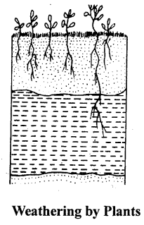
Exogenic forces work on the surface of the earth through water, wind and ice, resulting in changing the shape of landforms slowly.

Question 16.
Name the two land forms produced by exogenic forces.
Answer:

  1. Alluvial and erosional plains
  2. Glacial landforms.

Question 17.
Give one chief characteristic of the fold mountains.
Answer:
The fold mountains are formed by the lateral compression of sedimentary rocks as seen by the different layers of various types of rocks one upon another.

Question 18.
Give one example of volcanic mountains.
Answer:
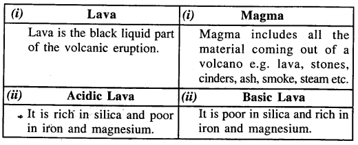
Volcanic mountains are formed by erupting magma from the inner core on the surface e.g. Mt. Krakatoa is an active volcano on the western side of Java.

Question 19.
How is a rift valley formed ? Give one example.
Answer:
A rift valley is formed by the submergence of a big landmass between two high block mountains, e.g. the Rhine river flows through a rift valley in its middle course.

Question 20.
Give a brief definition of a plateau.
Answer:
A plateau is a higher tableland between mountain and valley, lower than mountain and higher than valley.

Question 21.
Give one example of each

(a) Intermontane plateau
(b) Piedmont plateau
(c) Volcanic plateau.

Answer:

(a) The Tibetan plateau.
(b) The Patagonian plateau of South America.
(c) The Plateau of Peninsular India.

Question 22.
How are erosional plains formed ?
Answer:
Erosional plains are formed by the agents of erosion in millions of years, when the higher landforms are eroded into level plain areas, e.g. Lorraine plain in France.

Question 23.
Give two points of importance of landforms.
Answer:
Various landforms display the internal and external forces of the earth, different climatic effects and features, forests, snow lands giving birth to rivers, coasts and islands as fishing regions. All these together make the earth beautiful and ideal for living and various activities.

II. Distinguish between each of the following 

  1. Fold Mountain and Block Mountain.
  2. Intermontane plateau and Volcanic plateau.
  3. Structural plain and Depositional plains.
  4. Tectonic mountain and Volcanic mountain.

Answer:

1. Fold Mountain :

  1. Fold mountains is built by the tectonic forces folding the sedimentary rocks.
  2. These are formed of light sedimentary rocks e.g. the Himalayas

Block Mountain :

  1. Block mountain is built after the submergence of a landmass leaving behind the big blocks on the both sides.
  2. These are formed by solid rocks standing on the both sides of a rift valley. e.g. Vosges mountain in France.

2. Intermontane plateau : These are the highest and most extensive types on the globe surrounded by hills and mountains. The plateau of Tibet is the highest plateau as well as most extensive intermontane plateau. Other examples are Columbian Plateau, North Americal Cordillera, Bolivian, Peruvian and Mexican plateaus.
Volcanic Plateau : In places where fissure eruptions have taken place magma erupts quietly through narrow fissures several kilometres in length. This magma spreads on the surface and cools down as a sheet of lava covering the surface of the land. Eruptions at intervals lead to the piling up of lava sheets one over the other in a series of steps. The Deccan trap region of Peninsular India has several lava sheets having a maximum thickness of about 200 metres. This region forms a lava plateau. Other examples are South African plateau, Columbian Plateau and Ethiopian plateau.
3. Structural plain : It is formed by the uplift of landmass by Diastrophic forces creating an extensive lowland. The Missouri – Mississippi plain of U.S.A. is an example, which came out of ocean by uplift force.
Depositional plains : These plains are formed by the deposition of materials which have been brought by various agents of transportation, eg.

  1. River Deposition : The most widespread of these are alluvial plains like the Northern Plains of India; the flood plains like the Mississippi Plains in the USA, deltaic plains in Egypt and India
  2. Wind Deposition : Most of such plains are sandy deserts like the Sahara in Africa and the Thar desert in India. They have irregular and undulating surface made by existence of sand dunes and hallows.
  3. Marine Deposition : These plains are found in coastal regions. Examples are the east coast of India, the estuarine banks in the Netherlands, coast of Germany and Denmark.

4. Tectonic mountain :

  1. It is built by the tectonic force working on the crust of the earth.
  2. It is the result of upthrust force of the tectonic movement.
  3. It may be built by sedimentary or metamorphic rocks.

Volcanic mountain :

  1. It is built by the volcanic eruption from the interior of the earth.
  2. It is the result of upthrust force of magma coming up on the earth surface.
  3. It may be built by crystalline igneous rocks of particular composition.

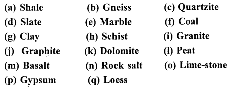
III. Give one technical term for each of the following 

Question 1.
Block mountains with flattened summits.
Answer:
Horst Mountains.

Question 2.
Plateaus surrounded by hills and mountains on all sides.
Answer:
Intermontane plateaus.

Question 3.
Plateaus formed by lava.
Answer:
Volconic plateaus.

Question 4.
An extensive area of lowland with a level or gently undulating surface.
Answer:
Plain.

Question 5.
The compressional forces that cause folding of rocks and formation of fold mountains.
Answer:
Diastrophic forces.

Question 6.
The vertical movements which are the result of faults and cracks in the surface of the earth.
Answer:
Epeirogenic forces.

Question 7.
The forces operating on the surface of the earth.
Answer:
Exogenic forces.

Question 8.
Plateaus surrounded by mountains on one side and plains on the other.
Answer:
Piedmont plateaus

P Q. Fill in the blanks with suitable words.

  1. Volcanic activity is a sudden movement.
  2. The upfolds of the rock strata are called anticlines.
  3. The Mid-Atlantic Ridge rises 3 km above the floor of the Atlantic.
  4. The Great Plain of the USA was formed by Diastrophic forces.
  5. The Great Northern plains of India were formed by River Deposition.

IV. Long Answer Questions.

Question 1.
1. Describe the formation of mountains and their types.
Answer:
Mountains are classified into three main types depending on the forces that have formed them. Three main types of mountains are

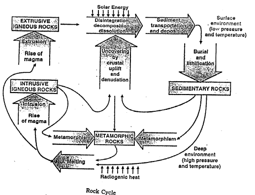
  1. Fold Mountains : Fold mountains are the result of large-scale earth movements caused by stresses in the earth’s crust. Such stresses may be caused by weight of the overlying rocks, movements in the mantle, the expansion or contraction of some part of the earth, etc. These stresses subject the rocks to compressive forces, producing wrinkling or folding along the lines of weakness. This is shown in fig. The raising of folds makes the fold mountains.
    ICSE Solutions for Class 9 Geography Chapter 5 Landforms of the Earth 2
  2. Residual Mountains : Mountains which are subjected to weathering and erosion for a longtime, are lowered down and called residual or relict mountains.
    Denudation and erosion by natural agents like winds, water, snow etc., cause the mountains to be lowered but some resistant areas may remain and form residual mountains.
    They may also be formed on plateaus that are dissected by rivers. For example the hills and valleys in the Deccan plateau.
    Some examples of Residual mountains are Nilgiri, Parasnath and Rajmahal Hills in India and the Catskill range in the USA.
    ICSE Solutions for Class 9 Geography Chapter 5 Landforms of the Earth 3
  3. Block Mountains : Horst or a block mountain is an uplifted land mass situated between two adjacent faults. The central block is upthrown or land on the outer-sides of the faults is downthrown so that the central mass appears like a highland. Its surface is like a plateau, but it has steep edges. The Vosges mountains to the west of the Rhine Rift Valley and the Black Forest mountain to the east of the Rhine Rift Valley are good examples of Horsts.
    ICSE Solutions for Class 9 Geography Chapter 5 Landforms of the Earth 4

Question 2.
Describe the characteristics of four different types of plateaus.
Answer:
Intermontane plateaus are the highest plateaus between highest mountains, e.g. Tibetan plateau. Piedmont plateaus lie between mountains and plains with steep slopes towards plains due to the force of flowing water downwards, e.g. Appolochian plateau of U.S.A., Patagonia plateau of South America Volcanic plateaus are created by volcanic eruption and Lava flows, e.g. Deccan plateau of peninsular India Uplifted plateaus are caused by the endogenic forces resulting in the dome shaped plateaus e. g. Chhotanagpur plateau in India

Question 3.
Describe the characteristics of structural plains.
Answer:
Structural plains are created by uplifting of a large landmass due to Diastrophic movements, e.g. plainofU.S.A. Erosionalplains are formed by eroding highlands into plain areas, e.g. Lorraine plain in France. Srinagar Valley of Kashmir is the result of glacial erosion, Sahara desert plain is the result of wind erosion. Karst plains are created by erosion of limestone rocks by ground water, e.g. Karst plain of Yugoslavia. Depositional plains are caused by large scale deposition of debris and silt deposited by the running water or rivers, e.g. Northern plain of India.

Question 4.
Explain the chief characteristics of depositional plains and their types.
Answer:
Depositional plains These plains are formed by the deposition of materials which have been brought by various agents of transportation, eg.

  1. River Deposition : The most widespread of these are alluvial plains like the Northern Plains of India; the flood plains like the Mississippi Plains in the USA, deltaic plains in Egypt and India
  2. Wind Deposition : Most such plains are sandy deserts like the Sahara in Africa and the Thar desert in India. They have irregular and undulating surface made by existence of sand dimes and hallows.
  3. Marine Deposition : These plains are found in coastal regions. Examples are the east coast of India, the estuarine banks in the Netherlands, coast of Germany and Denmark.

Question 5.
Give a brief account of importance of landforms on the surface of the earth.
Answer:
Landforms play an important role for human activities by providing different aspects of landscapes, climatic variety, natural gifts of snowclad ranges, glaciers and rivers etc., various vegetation zones imparting innumerable forest’ products, agriculture and other occupations related to different types of landforms, natural beauty and tourism all these making this earth fascinating living world.

Practice Questions (Solved)

Question 1.
Describe the direction in which the following mountain systems lie and also point out the continents where they are found.

(a) Alpine Himalayan System
(b) Rocky-Andean System

Answer:

(a) Alpine and Himalayan System both run from West to East direction in Europe and Asia continents respectively.
(b) Rocky-Andean System both run from North to South in the western margins of North America and South America continents.

Question 2.
Describe the different stages in the growth of mountains.
Answer:
There are three different stages in the growth of mountains.

  1. The geosyncline stage : The deposition of sediments in the sea-bed to form large geosynclines.
  2. The Orogenic stage : The tectonic forces working horizontally push and press there geosynclines to form various folds.
  3. Epeirogenic stage : When the whole mass of geosynclines is raised and buckled up and form a distinct series of troughs (synclines) and arcs (auticlines) i.e. Mountains and Valleys.

Question 3.
What are the different types of Geosynclines ?
Answer:
There are three types of Geosynclines

  1. Monogeosynclines : Long, narrow geosynclines along narrow water bodies take the shape of narrow mountains such as Appalachian mountains of North America.
  2. Polygeosynclines : Geosynclines laid down in wide and long water basin take the shape of broad and long mountain ranges like Rockies in North America.
  3. Mesogeosynclines : The geosynclines lying between Europe and Africa continents resulted in various mountain ranges e.g. Alps and Pyrenees in Europe, Atlas in Africa.

Question 4.
Write a note on the characteristics of folded mountains.
Answer:
Folded mountains are formed by the forces of compression and contortion resulting in a series of synclines and anticlines, later on undergoing various erosive forces. All the highest mountain systems are example of folded mountains made of sedimentary rocks.

Question 5.
What are Block mountains ? How are they formed ?
Answer:
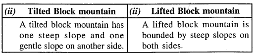
Block mountains are formed on the both sides of a rift valley, which is formed by deep submergence of a large landmass leaving behind two raised platform type blocks known as Block mountains. These landforms are created by displacement of landmass along fault lines known as faulting.

Question 6.
How can mountains be classified according to their different size and arrangement ? Describe in detail two of the classes of such mountains.
Answer:
Simply the mountains can be divided into 4 groups

  1. Folded mountains
  2. Block mountains
  3. Volcanic mountains
  4. Relict mountains

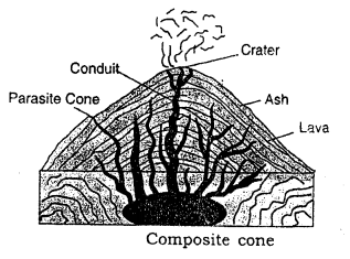
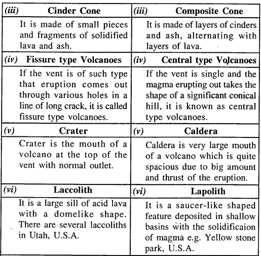
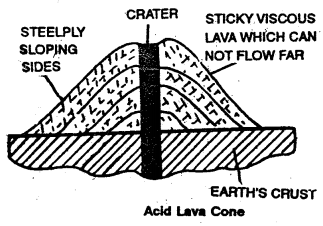
Volcanic mountains : are formed by the eruption and deposition of magma from the interior core to the land surface. According to their construction these are Cinder or Ash cones, Lava cones and composite cones, e.g. Fujiyama in Japan.
Relict mountains : These are formed by the continuous erosion ofthe original materials and giving birth to the hills of rounded peaks made of high density rocks, which have undergone excessive pressure and denudation by natural agents. One of the best example is Vindhyanchal mountain.

Question 7.
What are Block mountains ? How are they formed ?
Answer:
Horst or a block mountain is an uplifted land mass situated between two adjacent faults. The central block is upthrown or land on the outer-sides of the faults is downthrown so that the central mass appears like a highland. Its surface is like a plateau, but it has steep edges. The Vosges mountains to the west of the Rhine Rift Valley and the Block Forest mountains to the east of the Rhine Rift Valley are good examples of Horsts.
ICSE Solutions for Class 9 Geography Chapter 5 Landforms of the Earth 5

Question 8.
How can mountains be classified according to their different size and arrangement ?
Answer:
Mountains can be classified according to their different size and arrangement as given below :

  1. CordillersThese are large regions of mountains topography which are characterised by a large number of chains and ranges.
  2. System It is formed of several associated ranges. These ranges should be similar in position, form and structure although treanches or basins may separate them.
  3. ChainIt is a series of ridges in one line although separated by trough like valleys.
  4. RangeIt is a linear arrangement consisting of a large number of peaks and ridges separated by valleys. The different mountains possess a unity of form and structure.
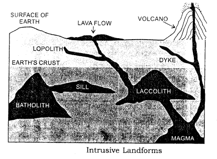
  5. Group It is a circular or massive arrangement of peaks and ridges. Group formations often result from the erosion of laccolths.
  6. Ridge It is the individual arch or block that results from folding and faulting. It may be of various types according as the slope is steep on one side or the other.
  7. Peaks These are formed by the less regular beds resisting denudation. They may be dome-like or pyramidical or needle-shaped. Their shape depends upon the rock structure and joint planes of the region. The peaks and ridges may either be arranged parallel to one another or may be quite isolated of may be arranged like features round a dome or they may be cones formed due to volcanic extrusion.

Question 9.
What are plateaus ? How are they different from mountains ? Give suitable examples.
Answer:
Plateaus Plateaus or table lands are elevated uplands, extensive in size and descending steeply to the surrounding regions. On the other hand, a portion of land surface rising considerably above the surroundings either as a single eminence or in a range if chain is called a ihountains.
Examples of Plateaus :

  1. Deccan Plateau of India.
  2. Tibetan Plateau (called the roof of the world)

Question 10.
What is a Piedmont Plateau ? How is it different from a Continental plateau ? Give suitable examples to illustrate.
Answer:
Piedmont Plateaus The plateaus which lie at the foot of the mountains are called Piedmont plateaus. These are flanked on one side by the plains or seas. The chief examples are the Colorado plateau or North America and the Patagonia Plateau of South America. Continental Plateaus The extensive and massive tablelands which rise abruptly from the bordering lowlands or from the sea are called continental plateaus. On most of their margins, there is sea. They seldom have mountainous rims. The major portion of Africa, Arabia, Spain, Australia, Peninsular India, Greenland and Antarctica are continental plateaus.

Question 11.
Write short notes on the following :

(a) Coastal plains
(b) Karst plains
(c) Peneplain
(d) Cuestiform plains.

Answer:

(a) Coastal plains : The plains situated near a sea coast are called coastal plains. They are formed by the sea waves after sea bottoms have emerged. The newly emerged plain is generally broad and wide and comprise of loosely compacted layers of mud and sand. Many coastal plains increased in which towards the sea because the sea waves continue adding matter to it.
(b) Karst plains : These plains are formed by the action of underground water, dissolving the regions made of chalk or limestone are called Karst plains. They are often flat-bottomed. Due to wind erosion and differential weathering, the topography is etched and rounded or even polished in a curious manner. Some of the relief features are quite fantastic in shape, especially the pebbles and other fragments that litter the surface of these plains.
(c) Peneplains : Very low undulating plains are called peneplains. They are almost plains.
(d) Cuestiform plains : The plains marked by a concentric arrangement of ridges and lowlands are called Cuestiform plains. Paris and London are the typical examples of such plains. They are made by river action on hard and soft rocks. Consequently they become rolling like the downs of S.E. England.

Question 12.
Why and how are the plains the centres of all human activity ?
Answer:
The plains are the centres of great economic advancement. The alluvial plains have been the cradles of civilisation from the earliest time. They have the following advantages to man:

  1. Railways, roads and waterways can be easily laid.
  2. They are the granary of the world.
  3. Due to fine climate, fertile soil and facilities for movement, the plains have become thickly populated and most of the big cities and towns are situated in the plains of the world except in areas which suffer from harsh climate and temperature.

Question 13.
Differentiate between Young fold mountains and Old fold mountains.
Answer:
Old fold mountains : The fold mountains which were formed about more than 250 million years ago are called old fold mountains. For example, the Urals in Russia, the Appalachians in North America and the Aravalli range in India are old fold mountains. These mountain ranges are of low altitude and have gentle slopes.
Young fold mountains : The most recent phase of mountain building took place about 25 million years ago. The world’s highest mountain ranges were formed during this period. These are known as young fold mountains. They have rugged relief features because they have been subjected to denudation for a comparatively short period only.

Question 14.
Give reasons for the following :

  1. Old fold mountains have low altitude and gentle slopes.
  2. Young fold mountains have rugged relief features.
  3. Young fold mountains are liable to Earthquakes and Volcanic action.

Answer:

  1. Old fold mountains have low altitude and gentle slopes because they have been subjected to denudations for million of years.
  2. Young fold mountains have rugged relief features because they have been subjected to denudation for a comparatively short period only.
  3. Young fold mountains are liable to Earthquakes and volcanic action because these mountain regions are areas of crustal instability.

Question 15.
State two evidences that the Earth movements have taken place in the past.
Answer:
The evidences that the Earth movements have taken place in the past are as follows :

  1. The basins containing sedimentary rocks indicate that such basins must have been below sea level in the past. The coalfields of the Damodar valley occur in such basins of the geological past.
  2. Oilfields occur in basins containing old sedimentary rocks. Such basins are now occurring on the land. This shows that the portion of the crust which was once depressed must have been uplifted later.
  3. llie Himalayas provide another evidence of the recent effect of Earth movements.

Question 16.
What causes Orogenic movemeiits ?
Answer:
Orogenic movements are caused by compressional or tensional forces.

Question 17.
What are the effects of Epeirogenic movements ?
Answer:
Effects of epeirogenic movements :

  1. They cause rising or sinking of the crust. They may cause the elevation of broad areas as extensive as those of a continent or lowering of the sea level.
  2. These movements are responsible for the formation of plateaux.

ICSE Solutions for Class 9 Geography – Rocks

ICSE Solutions for Class 9 Geography – Rocks

ICSE SolutionsSelina ICSE SolutionsML Aggarwal Solutions

Exercises

I. Short Answer Questions 

Question 1.
State two points of distinction between rocks and minerals.
Answer:
Rocks :

  1. Rocks contain minerals.
  2. Rocks are the aggregates of minerals and other rock material.

Minerals :

  1. Minerals do not contain rocks.
  2. Mineral are the compounds of pure elements with a definite chemical Composition.

Question 2.
Name any three elements of the earth’s crust.
Answer:
These are silicon, aluminium, iron, magnesium, calcium, potassium, sodium and nickel.

Question 3.
Name three types of rocks.
Answer:
Three types of rocks are sedimentary, igneous and metamorphic rocks.

Question 4.
Why are the igneous rocks also called the primary rocks?
Answer:
The igneous rocks were the first to be formed. They form the basis of formation of other types of rocks. Thus, they are called primary rocks.

Question 5.
Give one difference between Extrusive igneous and Intrusive igneous rocks.
Answer:

  • Extrusive igneous rocks are formed by the cooling of molten magma on the earth’s surface.
  • Intrusive igneous rocks are formed when the magma solidifies within the earth’s crust forming coarse texture.

Question 6.
Name any two chief characteristics of Igneous Rocks.
Answer:
Igneous rocks are formed by cooling of magma and these are crystalline rocks and full of mineral compounds.

Question 7.
What is the main characteristics of Basic Igneous Rocks?
Answer:
Basic igneous rocks have higher percentage of oxides of denser elements and dark in colour, e.g. Basalt, dolerite etc.

Question 8.
Name two important landforms made by Igneous Rocks.
Answer:
Conical mountains and extensive lava plateaus.

Question 9.
What are Sills ?
Answer:
The magma takes place in between the layers of rocks and hardens after cooling, which is called Sill.

Question 10.
Which rocks are associated with ores of metals ?
Answer:
Igneous rocks are associated with ores of metals due to their origin by cooling magma resulting in crystalline rocks rich in mineral content.

Question 11.
Which rocks are associated with fossil fuels ?
Answer:
Sedimentary rocks are associated with fossil fuels due to fossils trapped in between layers of these rocks.

Question 12.
Mention any two chief characteristics of Sedimentary Rocks.
Answer:

  • Sedimentary rocks are formed from material derived from other rocks including plant and animal remains. These rocks thus contain fossils.
  • Sedimentary rocks are generally not crystalline. They are soft and layered as they are formed by deposition of sediments.

Question 13.
Give two examples of Sedimentary Rocks.
Answer:

  1. Sandstone
  2. Limestone

Question 14.
Name the rocks which are most widespread on the earth.
Answer:
Sedimentary rocks are most widespread on the earth.

Question 15.
Name the three stages of lithification of Sedimentary rocks.
Answer:
Lithification is the process of turning loose rock material into hard rock through evaporation, compaction and cementation.

Question 16.
Name the types Sedimentary rocks based on agents of formation.
Answer:
There are five main types of rocks on the basis of agents of formation:

  1. Riverine Rocks These are formed by the sediments deposited by running water or river.
  2. Lacustrine Rocks These are formed by the deposition of silt etc on the bed of lakes.
  3. Glacial Rocks These are formed by the debris carried on and deposited by glaciers.
  4. Aeolean Rocks These are formed by the deposition sand accumulation by the wind.
  5. Marine Rocks These are formed by the deposition of sediments at the ocean floor. These types are Calcarious and Carbonaceous sedimentary Rocks.

Question 17.
Which agents are responsible for deposition of sediments?
Answer:
There are three main agents of deposition i.e., water, wind and ice, which mainly act as agents of change on the surface of earth for deposition of sediments.

Question 18.
What are known as metamorphic rocks ? Give two examples.
Answer:
Metamorphic rocks are formed by complete change of texture of rocks through volcanism and diastrophism, e.g., limestone is converted to marble and shale is transformed to slate.

Question 19.
What is Mechanical Metamorphism ?
Answer:
This is a mechanical Transformation in which texture of rocks is changed by crushing and rubbing processes associated with heat and compression created by mechanical action.

Question 20.
What is meant by Rock Cycle ?
Answer:
The earth is said to be 4700 million years old and the rocks came into existence 3400 years ago. Since then these rocks have undergone various changes by which multiple transformation took place within the rocks. This continuous process of transformation of old rocks into new rocks is known as rock cycle for figure See Page no. of this book.

Question 21.
What processes are involved in the formation of Igneous Rocks ?
Answer:
Igneous rocks are associated with volcanic activity, cooling of magma and mechanical weathering etc.

II. Explain these terms associated with rocks.

Question 1.
Extrusive Igneous Rocks.
Answer:
These rocks are formed by consolidation of erupted magma on the surface of earth.

Question 2.
Laccoliths and Batholiths.
Answer:
Laccoliths is formed by the intrusion of magma in the erupting channel just below the crust. Batholiths are deep seated dome shaped formation of magma intrusion, generally forming the base of mountain ranges, e.g., Ranchi Batholiths.

Question 3.
Fossil fuels.
Answer:
These are the fuels accumulated between two impermeable layers of the sedimentary rocks, e.g. peat, coal and petroleum etc.

Question 4.
Lithification of Rocks.
Answer:
It is the process of turning the loose material into hard rock, which helps in the formation of the sedimentary rocks found in different layers one upon another.

Question 5.
Metamorphism.
Answer:
It is the process of transformation of sedimentary and igneous rocks into metamorphic rocks through extreme temperature and compression by volcanism and diatrophism by physical and Chemical changes.

III. Distinguish between each of the following

P Q. Lava and Magma.
Answer:
Lava : Lava is the black molten material erupted in a volcano.
Magma : Magma is the compound of lava, stones, ash, debris etc. erupting out in a volcano.

Question 1.
Plutonic and Volcanic rocks.
Answer:
Plutonic rocks :

  1. These are intrusive igneous rocks.
  2. These cool down very slowly due to heat in the interior

Volcanic rocks :

  1. These are extrusive igneous rocks.
  2. These cool down abruptly due to less temperature on the surface region.

Question 2.
Thermal and Dynamic Metamorphism.
Answer:
Thermal Metamorphism :

  1. It takes place due to extreme temperature which transforms the shape and texture of rocks.
  2. The heat may be due to hot magma or friction of rocks.

Dynamic Metamorphism :

  1. It takes place due to excessive compression created by tectonic forces within the earth.
  2. It takes place through physical or chemical changes by deep pressure.

Question 3.
Sills and Dykes.
Answer:
Sills : The collection of magma between layers of rocks is called sill.
Dykes : The fillings of magma in the cracks or fissures of rocks are called dykes.

Question 4.
Calcarious and Carbonacious rocks.
Answer:
Calcarious rocks : The sedimentary rocks formed by the deposition of shells, skeletons of sea organism as corals, clams and oysters etc. are called calcarious rocks due to excess of calcium.
Carbonacious rocks : The sedimentary rocks formed by the deposition of large scale vegetation and animals etc. are called carbonacious rocks due to the excess of carbon.

Question 5.
Acid Igneous Rocks and Basic Igneous Rocks.
Answer:
Acid Igneous rocks : These are lighter rocks with silica content 65 to 85 percent with density less than 2 g/Cm3, e.g. Granite.
Basic igneous rocks : These are denser rocks with silica content 40 to 60 percent with average density between 2.8 g/Cm3 and 3.0 g/Cm3 e.g. Basalt.

IV. State the types of rocks for the formation of which the following processes are involved.

Question 1.
Solidification of magma on the surface of the earth.
Answer:
Extrusive igneous rocks

Question 2.
Formation of large crystals, coarse texture and slow cooling and compaction.
Answer:
Intrusive igneous rocks.

Question 3.
Accumulation takes place over long periods of time in seas, lakes and streams.
Answer:
Sedimentary rocks.

Question 4.
Decomposition of organic matter at different stages and over different periods of time.
Answer:
Carbonaceous Sedimentary rocks.

V. Long Answer Questions

Question 1.
Distinguish between rocks and minerals.
Answer:
The rocks contain minerals in the form of ores, but minerals do not contain rocks. Sedimentary rocks contain fossil fuels like coal and petroleum etc, igneous rocks are rich in minerals like copper, gold, iron etc, metamorphic rocks contain valuable building stones like marble and garnet, feldspar etc. Rocks have no definite chemical composition, while minerals have particular chemical composition.

Question 2.
Describe how are igneous rocks formed ? State their chief characteristics.
Answer:
Igneous rocks are formed by melting and cooling of magma originated from volcanic eruptions. These may be formed by diastrophism and volcanism. These rocks are strong, crystalline and dark in colour. These may be extrusive and intrusive on the surface and beneath the crust respectively.
ICSE Solutions for Class 9 Geography Chapter 6 Rocks 1

Question 3.
How are igneous rocks classified on the basis of their chemical composition?
Answer:
On the basis of chemical composition igneous rocks may be classified into two groups i.e. Acid igneous rocks and Basic igneous rocks. Acid rocks have silica content 65-85 percent e.g. granite which is made up of large crystals of quartz, feldspar and mica. Basic rocks contain high percentage oxides of denser material, silica content is between 40-60 percent with a density of 2.8 g/cm3 and 3.0 g/cm3. Acid rocks are lighter than Basic rocks.

Question 4.
Classify the igneous rocks on the basis of their place of origin.
Answer:
On the basis of origin igneous rocks are divided into two groups i.e. Extrusive and Instrusive igneous rocks. Extrusive igneous rocks are found on the surface of the earth by cooling down of erupted magma. Intrusive igneous rocks are formed beneath the earth’s crust after solidification of magma.

Question 5.
How are sedimentary rocks formed ?
Answer:
Continuous deposition of sediments of silt, soil, debris etc. by water, wind and ice along lower landforms and solidification into different layers result in the formation of light sedimentary rocks.

Question 6.
Explain the formation of sedimentary rocks on the basis of agents of formation.
Answer:
There are five main types of rocks on the basis of agents of formation:

  1. Riverine Rocks These are formed by the sediments deposited by running water or river.
  2. Lacustrine Rocks These are formed by the deposition of silt etc on the bed of lakes.
  3. Glacial Rocks These are formed by the debris carried oh and deposited by glaciers.
  4. Aeolean Rocks These are formed by the deposition sand accumulation by the wind.
  5. Marine Rocks These are formed by the deposition of sediments at the ocean floor. These types are Calcarious and Carbonaceous sedimentary Rocks.

Question 7.
How are sedimentary rocks classified on the basis of their formation ?
Answer:
There are three types of this type of rocks :

  1. Mechanically formed rocks : Denudation of rocks by agents of change results in layers of sedimentary rocks by mechanism.
  2. Chemically formed rocks : These are formed by evaporation of calcarious water and accumulated along lake and lagoon beds, e.g. gypsum and rock salt.
  3. Organically formed rocks : These are formed by deposition of dead plants and animals e.g. limestone rock (or Calcareous rock) lignite, bituminous and anthracite coal are carbonaceous rocks formed by compression of vegetation under the layers of sedimentary rocks. In the same way petroleum in between the sedimentary rocks is the result of zurasic age dinosaurs e.g. shale rock, containing oil.

Question 8.
What is metamorphism ? What are its causes ?
Answer:
Metamorphism is a process of transformation of sedimentary and igneous rocks into the metamorphic rocks through physical and chemical reactions. Main causes are great temperature and pressure beneath the earth’s crust, which changes the original texture and form of the rocks into dense, crystalline and fine grained rocks.

Question 9.
What are the chief characteristics of metamorphic rocks?
Answer:
Metamorphic rocks are composed of fine particles and dense, smooth material. These are very precious rocks, particularly for building stones like marble, garnet, slate quartzite etc.

Question 10.
What is Rock Cycle. How does it keep the earth young?
Answer:
The earth is said to be 4700 million years old and the rocks came into existence 3400 years ago. Since then these rocks have undergone various changes by which multiple transformation took place within the rocks. This continuous process of transformation of old rocks into new rocks is known as rock cycle.
ICSE Solutions for Class 9 Geography Chapter 6 Rocks 2

To keep the earth young, rock melts again resulting in formation of igneous rock. This disintegrated material again form sedimentary rock, it takes hundreds are thousands years.

Question 11.
Give a detailed account of lithiflcation of sedimentary rocks.
Answer:
Lithification means solidification. The loose material carried on by water, wind and ice is deposited slowly in different layers one upon another. Gradually the deposited sediments become solid and hard due to pressure and temperature. Evaporation results in the loss of water within the sediments and these are compacted and cemented. Compaction takes place by increasing weight and pressure of over lying sediments e.g. sand is converted to sandstone. Cementation takes place by bonding of compacted sediments by natural elements like calcium compounds, silica and iron with a property to bind the loose materials to solid state.

Practice Questions (Solved)

Question 1.
(a) What is meant by a rock ?
Or
What is meant by a ‘rock’ ? Name the main types of rocks.

(b) Differentiate between Rock and Mineral
(c) How are sedimentary and igneous rocks formed ?
(d) In what type of rocks do you find fossils and why ?
(e) How are rocks important to us ?

Answer:
(a) Rock : A rock can be defined as “an aggregate of minerals that forms a more or less definite unit of the earth’s crust”. A rock does not possess a definite composition like that of a chemical compounds, but is usually a mixture of various minerals.
The bulk of rocks is made up of silica or quartz and feldspar. Feldspar are composed of silica, aluminium, potassium and sodium or calcium. Some rocks are composed of grains cemented together, while several other are crystalline, compact or even glass-like.
All material (whether hard like stone or sand) of which the crust of the earth is composed are called rocks e.g, stone, clay, lava, sand, chalk, salt, coal marble etc.. On the basis of their mode of formation, rocks are divided into three types :

  • Igneous rocks
  • Sedimentary rocks
  • Metamorphic rocks.

(b)
Rock :

  1. A rock is a natural solid organic or inorganic material forming the crust of the earth.
  2. A rock is an aggregate of minerals.
  3. The physical properties of rocks vary.

Mineral :

  1. The mineral is an organic element or compound which occurs naturally.
  2. A mineral has an atomic structure.
  3. It has fixed definite physical properties.

(c) Formation of Sedimentary rocks : Sedimentary rocks are formed by the process of consolidation of sediments deposited commonly in water bodies like seas or lakes. The sediments are derived by the rivers, glaciers, winds and waves. The sediments consist of loose particles of gravel, sand, silt and clay in various proportions. These loose particles get consolidated or compacted into hard rocks by the presence of cementing substances like lime or the pressure of overlying deposits.
Formation of igneous rocks : The rocks which are formed by the process of solidification of molten rock material (magma), are called igneous rocks.
The processes involved in the formation of igneous rocks are cooling and solidification.
Two types of igneous rocks are

  • Intrusive igneous rocks
  • Extrusive igneous rocks.

Formation of extrusive rocks : These rocks are also known as volcanic rocks, because they are formed by the solidification of lava on the earth’s surface. As on the outer surface of the earths’ crust the rate of cooling and solidification is more rapid than in the interior, the different minerals composing the magma have less time to become crystalline. The crystals formed are small. Basalt is a good example of this type of rock. Extrusive rocks are much more fine-grained as compared to intrusive granite. The hot magma free of gases is converted into lava on reaching the surface. It takes the form of lava flows, lava sheet and lava plateau. The north-western part of Peninsular India, known as the Deccan Trap, covers a great area of basaltic regur soil formed by the weathering of these rocks. Basaltic lava rocks cover a wide area in Columbia, the Snake Plateau of U.S.A. The other name of extrusive rock is Volcanic
Rock The properties of extrusive rocks :

  1. These rocks are formed by the solidification of lava on the earth’s surface.
  2. These rocks are very fine-grained.
  3. They are usually dark coloured.

The other name given to intrusive rock is Plutonic rock.
Formation of intrusive rocks : When the molten material of the interior part of the earth’s crust finds its way through clefts or spaces that it has made by pushing the surrounding rocks apart, and does not reach the surface. This is known as the Intrusive Rocks. Dolerite and granite are the best examples of intrusive rocks.
Properties of intrusive rocks :

  1. They have large crystals.
  2. They are very compact.
  3. They are glassy in appearance.

(d) Fossils are found in sedimentary rocks. Organic remains of plants and animals or their skeletal impressions are called fossils. Fossils help us in fixing the relative ages of rocks.
(e) The dead sea abounds in chemically formed sedimentary rock because the evaporation of water from it is rapid.

Question 2.
(a) Name different types of sedimentary rocks.
(b) What physical agents are involved in the sedimentary rocks ?
(c) How are chemically-formed sedimentary rocks produced?
(d) How are chemically-formed sedimentary rocks formed? Give examples.
(e) Sedimentary rocks are also called stratified rocks. Why?
OR
Why sedimentary rocks are called stratified rocks ?
Answer:

(a) There are three types of sedimentary rocks on the basis of the nature of sediments, their origin, composition and mode of formation. These are mechanically-formed sedimentary rocks, organically formed sedimentary rocks and chemically- formed sedimentary rocks.
(b) Rain water, wind, ice or the running water are the agents involved in the formation of sedimentary rocks. These agents break and carry on loose material and deposit it in various low lying areas to convert into the solid sedimentary rocks.
(c) Chemically-formed sedimentary rocks are produced through evaporation of water from solutions containing minerals. In this ways a rock like ‘gypsum’ is produced. Other examples are nitrates and potash etc.
(d) Chemically formed sedimentary rocks are formed through chemical action of water. Some mineral like limestones and salts are dissolved into the water and after the evaporation of water form a particular type of rock which is formed by the chemical sedimentation of limestones into gypsum and salt into various types of nitrates.
(e) During the formation of sedimentary rocks, the sediments are deposited in waterbodies and get sorted out according to their size. The sediments accumulate in different layers or strata arranged one above the other. Each layer or stratum has particles of given size. In sedimentary rocks each layer or stratum has particles of a given size. Therefore, sedimentary rocks are also called stratified rocks.

Question 3.

(a) What is meant by the term ‘metamorphism’ ?
(b) Distinguish between Thermal metamorphism and Dynamic metamorphism.
(c) Distinguish between Regional and Contact metamorphism.
(d) What are metamorphic rocks ?
(e) Give some examples of metamorphic rocks formed from sedimentary and igneous rocks.

Answer:
(a) The term metamorphism means change of form. It may be physical or chemical or both.
(b) Thermal metamorphism : When the transformation of the original rock takes place principally because of the influence of high temperature, the rock is said to be caused through Thermal metamorphism. For example, graphite (from coal) and slate (from clay). The heat may result from the intrusion of hot magma or from the friction of moving rock layers. It may also occur due to chemical changes.
Dynamic metamorphism : When the transformation of the original rock takes place mainly because of the influence of pressure at a great depth within the earth’s crust, it is known as Dynamic Metamorphism.
(c) Regional metamorphism When metamorphism of bed rocks takes place over a very large area, it is called Regional metamorphism. It is usually caused by the movement of the earth’s crust. Contact metamorphism when it takes place over a small area, it is called Local Metamorphism or Contact Metamorphism. It commonly occurs when hot magma comes in contact with other rocks.
(d) Metamorphic rocks are those rocks which were formerly igneous or sedimentary rocks, but owing to extreme heat and pressure in the interior of the earth it has been changed or altered to such an extent that they are quite different from what they once were slate, which is in reality clay, and marble’ which is in reality lime stone. Other examples of metamorphic rocks are quartzite from sand stone, graphite from coal, gneiss from granite and Mica from Schist.
(e)
(a) Sedimentary Rocks :

  1. Limestone
  2. Clay and Shale
  3. Sandstone
  4. Coal

Metamorphic Rocks :

  1. Marble
  2.  Slate
  3. Quartzite
  4. Graphite

(b)
Igneous Rocks :

  1. Granite
  2. Basalt

Mctamorphic Rocks :

  1. Gneiss
  2. Schist

Question 4.
Classify the following rocks into sedimentary, igneous and metamorphic
ICSE Solutions for Class 9 Geography Chapter 6 Rocks 3
Answer:

(a) Shale — Sedimentary rock
(b) Gneiss — Metamorphic rock
(c) Quartzite — Metamorphic rock
(d) Slate — Metamorphic rock
(e) Marble — Metamorphic rock
(f) Coal — Sedimentary rock
(g) Clay — Sedimentary rock
(h) Schist — Metamorphic rock
(i) Granite — Igneous rock
(j) Graphite — Metamorphic rock
(k) Dolomite — Sedimentary rock
(l) Peat — Sedimentary rock
(m) Basalt — Igneous rock
(n) Rock salt — Sedimentary rock
(o) Lime-stone — Sedimentary rock
(p) Gypsum — Sedimentary rock
(q) Loess — Sedimentary rock

Question 5.
Give one word for the following

(a) The outer layer of the earth.
(b) The lower part of ocean floor, comprising mainly of silica.
(c) Rocks formed by the cooling and solidification of molten rock from beneath the earth crust.
(d) Stratified rock formed organically but from vegetative matter-swamps and forests.
(e) The upper part of lithosphere, which is rich in silica and aluminium.
(f) The core of the earth occupied by rock in iron and nickel.
(g) Igneous rocks, which contain a high percentage of silica.
(h) Igneous rocks, which contain a low percentage of silica.
(i) A sedimentary rock, which is composed of microscopically fine, soft and smooth particles.
(j) The best example of chemically-formed sedimentary rock, which has been formed by the evaporation of water from solution containing minerals.

Answer:

(a) Crust
(b) SIMA
(c) Igneous rocks
(d) Carbonaceous rocks
(e) SIAL
(f) Nife
(g) Acidic igneous rocks
(h) Basic igneous rocks
(i) Clay
(j) Gypsum

Q. 6. Fill in the blanks

  1. The interior layer is the core, which is made up mainly of iron and nickel, and is called Nife.
  2. Organically formed sedimentary rocks are formed by the deposition of shells and skeletons of organism.
  3. Breccia rock is formed, when the angular and coarse grains of some durable minerals are cemented together.
  4. Aeolian is the best example of the wind deposited stratified rock.
  5. Basic igneous rock contain a low percentage of silica and a high percentage of basic oxides.
  6. Extrusive rocks are also known as volcanic rocks.
  7. Basaltic lava rocks cover wide area in Peninsular India and Columbia, the Snake Plateau of the U.S.A.

Question 7.
Give one example of an area of :

  1. Igneous rocks
  2. Metamorphic rocks,
  3. Sedimentary rocks in India

Answer:

  1. Deccan Plateau
  2. Narmada Basin
  3. Himalayan Region

Question 8.
What is the basis for the classification of rocks ?
Answer:
The basis for the classification of rocks are their mineral composition, colour and texture.

Question 9.
Why are Sedimentary rocks called the Secondary rocks?
Answer:
Sedimentary rocks are called Secondary rocks or derived – rocks because they are derived by the denudation of other rocks.

Question 10.
How are sedimentary rocks classified ?
Answer:
Sedimentary rocks are classified into the following types according to the nature of sediments, their origin, composition and the mode of formation.

  1. Inorganic rocks or Mechanically-formed Sedimentary Rocks :- These type of rocks are formed by the deposition of land derived material. When the river began to flow, they eroded the rocks and washed away to the sea. Clay, shale, sandstone were formed in this way. These rocks are called inorganic rocks.
  2. Organically formed Sedimentary Rocks :- These rocks are formed by the deposition of plants and sea organisms. Millions of years ago, there grew huge forest in marshy places. In course of ages they were buried underground and the internal heat changed them into coal. Moreover, there are millions and millions of sea-organisms whose skeleton are made of Calcium carbonate derived from sea water. After their death skeleton sink to the bottom of the seas and are formed into lime true and chalk and coal.
  3. Chemically-formed Sedimentary Rocks :- There rocks are formed by the evaporation of water from solution containing mineral. Various kinds of salts precipitate from waters of shallow desert lakes, where evaporation of the water is rapid. Gypsum is the best example of this kind of rocks. Several nitrates and potash are also chemically formed sedimentary rocks.

Question 11.
State the properties of metamorphic rocks.
Answer:
Properties of metamorphic rocks :

  1. These rocks are harder and more resistant than the original rocks.
  2. These rocks have their minerals arranged in a series of bands.

Question 12.
Give one term for the following statements :

  1. Formed when mud layers compacted under great pressure composing 80% of this rock.
  2. It has a definite chemical composition with its own chemical and physical properties.
  3. Igneous rocks of deep seated origin.
  4. Sheet like body of igneous rock.
  5. Rounded or sub-rounded fragments, usually water-born cobbles, pebble and gravel, cemented together by a matrix of calcium carbonate, silica, etc.
  6. Formed by evaporation in saline lakes.
  7. Fine grained metamorphic rock, generally produced by the low grade metamorphism of shale.
  8. Type of metamorphism in which changes are caused due to high pressure.

Answer:

  1. Shale
  2. Mineral
  3. Plutonic rocks
  4. Sill
  5. Conglomerate
  6. Rock salt
  7. Slate
  8. Dynamic metamorphism.

Question 13.
Why are the Igneous Rocks called Primary Rocks ?
Answer:
It is believed that the earth was in a molten state in the beginning Igneous rocks were the first rocks to be formed due to cooling and solidification of molten matter. Hence these are called Primary Rocks.

Question 14.
Why fossils are preserved in Sedimentary and not in Igneous rocks ?
Answer:
Fossils are remains of vegetation and animals buried under the sediments. The sedimentary rocks are stratified rocks and are found in layers. These fossils are preserved in between these layers. But in Igneous rocks, the fossils are destroyed due to high temperature of lava.

Question 15.
How is Plutonic rock formed ? Give an example of an Plutonic rock.
Answer:
Plutonic rocks are the igneous rocks which are formed as some depth in the earth’s crust, when a molten material gets solidified under pressure. Granite is very good example of a Plutonic rock.

Question 16.
Give reasons for the following :

  1. Extrusive rocks generally have small crystals.
  2. Silicates are the most common rock forming minerals.
  3. Rocks are of great economic significance.
  4. Man’s habitat is the biosphere and not the lithosphere in the true sense.

Answer:

  1. Extrusive rocks generally have small crystals because in the formation of these rocks, the solidification of magma takes place at a slower rate.
  2. Silicates are the most common rock forming minerals because they are most common minerals in the Earth’s crust.
  3. Rocks are of great economic significance Some of the main benefits of rocks are as follows :
    • After disintergration, they turn into valuable soils.
    • They are the store-houses of a large number of minerals.
    • They are the source of precious metals like gold, silver, platinum etc.
    • They are source of fuel-minerals.
    • They provide different types of stones.
  4. The composite zone inhabited by most living creatures is called biosphere. It includes a part of the atmosphere, the hydrosphere and a part of the lithosphere. All three layers are essential for life to exist.
    As lithosphere is only a small part of the biosphere, therefore, man’s habitat is the biosphere and not the lithosphere in the true sense.

Question 17.
Distinguish between Intrusive and Extrusive Rocks :
Answer:
Intrusive Rocks :

  1. Intrustive rocks are formed beneath the surface of the Earth.
  2. These rocks have large size crystals due to slow cooling.
  3. These are also known as plutonic rocks.
  4. Granite is an example of these rocks.

Extrusive Rocks :

  1. Extrusive rocks are formed on the surface of the Earth.
  2. Crystals are not formed due to rapid cooling of lava.
  3. These are also known as volcanic rocks.
  4. Basalt is an example of these rocks.

ICSE Solutions for Class 9 Geography – Earthquakes

ICSE Solutions for Class 9 Geography – Earthquakes

ICSE SolutionsSelina ICSE SolutionsML Aggarwal Solutions

Exercises

I. Fill in the blanks below

  1. Most earthquakes occur on account of the strain in the earth’s crust.
  2. P (primary or push waves) are the first earthquake waves to be recorded on a seismograph of an earthquake.
  3. The last of the earthquake waves to arrive on the surface of the earth are L (surface or long) waves.
  4. The giant sea waves caused by earthquakes in the oceans are called Tsunamis.
  5. About 70 per cent of the earthquakes occur in the Circum- Pacific-Mountain Belt.

II. Short Answer Questions

Question 1.
What is called an earthquake ?
Answer:
An earthquake is defined as a tremor below the surface of the earth which causes shaking of the earth.

Question 2.
State two natural causes of an earthquake.
Answer:
Natural causes are the movement of tectonic plates and volcanic activities.

Question 3.
Name one man-made cause of an earthquake.
Answer:
Construction of large scale dams, thrust of rivers along fault lines, dumping of chemical wastes also cause earthquakes due to imbalance in isostatic balance of the earth’s landforms, e.g. Koyna dam caused an earthquake in Maharashtra.

Question 4.
What are known as seismic focus and epiceptre with respect to an earthquake ?
Answer:
The point of origin of earthquake waves is called seismic focus and the centre vertically above the seismic focus nearest to the earth’s crust is called epicentre.

Question 5.
What is known as Richter scale ? State its uses.
Answer:
Ritcher scale is used to measure the intensity of earthquake through a scale, which is motivated by a needle attached to this instrument The zigzag wavelength of the earthquake comes on the screen and calculated from 1 to 9 scale measured in centimetres.

Question 6.
How are earthquakes useful ?
Answer:
Earthquakes cause energy release to put the earth in good shape; several landforms are uplifted to build large plains e.g. Sagami Bay uplifted 200 m, Landslides cause the formation of lakes in Himalayan region.

Question 7.
Give any two destructive effects of earthquakes ?
Answer:
Destructive effects are collapse of structures, submergence of coastal parts e.g. Dwarka submergence, these change the course of rivers, danger to human life and motivation of tsunami waves causing drastic calamities.

Question 8.
What is tsunami ? How is it caused ?
Answer:
Tsunami is a large furious destructive sea waves caused by the force of an earthquake along the moving tectonic plates, volcanic activity landslides and meteorite impact.

Question 9.
How do Japanese predict earthquakes ?
Answer:
Japanese use the methods of measuring changes in sea level and variations in Earth’s magnetic field to predict earthquakes.

Question 10.
Name the two belts where most of the earthquakes occur.
Answer:
Two belts are the Circum-Pacific Mountain belt and the midworld mountain belt of high fold mountains like the Alps, Himalayas etc.

III. Match the following
ICSE Solutions for Class 9 Geography Chapter 8 Earthquakes 1
Answer:
ICSE Solutions for Class 9 Geography Chapter 8 Earthquakes 2

IV. Long Answer Questions

Question 1.
Describe how earthquakes are caused on the surface of the earth.
Answer:
When the earth’s crust is unable to accommodate itself to the strain due to isostatic imbalance, so sudden release of energy results in violent shock or an earthquake. The earthquakes are caused by severe tectonic movement of plates, volcanic eruption forces and isostatic imbalance often taking place due to diastrophism creating ups and downs in landform construction.

Question 2.
Explain the three types of earthquake waves. What is the difference between seismic focus and epicentre ?
Answer:
Three types of earthquake waves are :

  1. P-primary waves,
  2. S-Secondary (or Shear waves) and
  3. L-Long waves (or Surface waves).
    ICSE Solutions for Class 9 Geography Chapter 8 Earthquakes 3

Seismic focus.is located in the interior of earth’s crust from where the earthquake waves originate and the epicentre is the nearest point vertically below the region of earthquake effect.

P Q. What is the Tsunami ? How ist it produced ? What are its effects ?
Answer:
Tsunami is very destructive sea wave rising high upto several metres and jump furiously along the coastal areas like the hood of a snake. The name ‘tsunami’ is from the Japanese words : ‘Tsu’ and ‘nami’ meaning ‘harbour’ and ‘wave’ respectively. So tsunamis are harbour waves.
It is produced mainly by undersea earthquake along the gaps of tectonic plates, volcanic thrusts, great landslides and meteorite impact.
They can cause a lot of destruction on the shore. They are sometimes mistakenly called “tidal waves,” but tsunamis have nothing to do with the tides.

Question 3.
Compare and contrast the constructive effects and the – destructive effects of an earthquake.
Answer:
Constructive effects :

  1. Earthquakes help the earth release its stored up energy. The majority of the earthquake occur around. The plate margins. This energy release helps to keep the earth in good shape.
  2. On account of both vertical and lateral displacement of the earth’s crust, earth-quakes may raise or lower parts of earth especially near the seashore. Sagami Bay of Japan was uplifted 200 m in 1923.
  3. Landslides triggered by earthquakes cause formation of lakes as has happened at many places in the Himalayan region.

Destructive effects :

  1. Human beings have settlements in active earthquake zones. Most often the houses and other structures collapse causing great loss of property.
  2. The forces of uplift and subsidence also cause submergence of coastal parts. For example: Dwarka in Gujarat which now lies submerged under the sea.
  3. Earthquakes have changed the course of rivers in the past. They have thus rendered many areas unsuitable for irrigation and agriculture. They cause danger to human life.

Question 4.
Is it possible to predict an earthquake ? Give reasons to support your answer.
Answer:
No till now it is not possible to predict an earthquake. Earthquake prediction in the past was left to astrologers and mystics. Today it is a respectable scientific pursuit. The Russians were the first to discover P and S seismic waves in 1960s on the basis of which predictions were made. These waves still are the only means available to seismologists to predict earthquakes.
The theory of Plate Tectonics offers another means of prediction on scientific lines. Japanese use the methods of measuring changes in sea level and variations in Earth’s magnetic field to predict earthquakes. However, no method is still foolproof as has been proved by recent earthquakes in Japan, India and the USA.

Question 5.
How are earthquakes distributed over the globe ?
Answer:
The earthquakes are common along the weak tectonic belts affected by continuous tremors due to the movement of plates one upon another. Main belts are Circum-Pacific Mountain belt and Mid-World Mountain belt of fold mountains which are still in the process of upthrust forces increasing their height.

Question 6.
How is the intensity of earthquakes measured ? What instruments are used ?
Answer:
Ritcher scale and Mercalli scale are used to measure the intensity of earthquakes. Ritcher scale measures through a graphical scale in zigzag graph from 1 to 9 and Mercalli scale observes it from 1 to 12 points scale.

Practice Questions (Solved)

Question 1.
(a) What is an Earthquake ?
(b) How it is caused ?
(c) Describe the world’s distribution of earthquakes.
(d) What are the advantages and disadvantages of Earth quakes.
OR
What are the effects of Earthquakes ?
(e) Name the major earthquakes of India from 1991 to 1997.
Answer:
(a) The sudden mild or violent shaking of a part of the earth is called an earthquake. An earthquake is generally accompanied by a rumbling and tremors.
(b) Causes The chief known causes of earthquakes are believed to be as follows :

  1. When a dormant volcano erupts into activity or an active volcano discharges matter with greater violence the surrounding areas feel tremors or earthquakes.
  2. When the interior of the earth cools and contracts the outer crust in some places cracks and faults are caused. This movement causes earthquake.
  3. Some time water percolates so deep down into the earth that it turns into steam on account of the internal heat. This steam expands and tries to force its way out. This pressure causes an earthquake.

(c) The earthquakes are distributed along two major belts namely circum Pacific earthquake belt (Ring of fire) and the Mid¬World, Mountain Earthquake belt along the great fold mountain zone.
(d) Earthquakes brings about changes on the surface of the earth which are very harmful to man.

Destructive Effects :

  1. Many towns are destroyed and there is considerable loss of life and property.
  2. They cause floods by uplifting of land in the’ course of river.
  3. Some places are submerged under the sea.
  4. Big cracks and fissures are formed on the surface of the river and they interrupt communications.
  5. Some times rivers disappear or change their courses or get flooded. Railway lines are twisted.
  6. They cause great tidal waves, which may bring havoc to the coastal areas.

Constructive Effects :

  1. Precious metals and minerals come up to the surface for the use of man.
  2. New lands for habitation above the surface of the sea are formed.
  3. Some times new springs and water falls are formed which help in irrigation.
  4. Violent earthquakes have led to the formation of hills and mountains.
  5. Bays and gulfs are formed along the coastal land to provide new ports and harbours.

(e) Major earthquakes of India from 1991 to 1997

  1. Latur -1991
  2. Uttarkashi – 1993

Question 2.
Name the important Earthquake-belts of the world.
OR
Indicate two major belts of Earthquakes.
Answer:

  1. Circum – Pacific Earthquake Belt :- i.e. round the Pacific Ocean. This belt goes along with the coast of America and East coast of Asia.
  2. Mid World Mountain Earthquake Belt :- This belt runs through the middle of Asia from East and goes beyond the Mediterranean sea as far as the West Indies. This belt, however, is not so active as Pacific Belt.

Question 3.
Name the instrument used to record Earthquakes.
Answer:
The instrument used to record Earthquakes’ is called Seismograph.

Question 4.
Name some Earthquakes which caused great damage.
Answer:
Some Earthquakes which caused serious damage to property and life are :

  1. Lisbon Earthquake of 1755
  2. South Carolina Earthquake of August 1886
  3. The Japan Earthquake of Oct. 28, 1891
  4. Kanga (Himachal pradesh) Earthquake of April 1905
  5. Tokyo (Japan) Sep. 1923
  6. Quetta 1935
  7. Bihar 1934
  8. California Earthquake of April, 1966
  9. Turkey Sep. 1975
  10. Iran 1968
  11. Peru 1970
  12. Tangshan (China) Earthquake of July, 1976
  13. Broach Earthquake of 1970 affected part of Gujrat.
  14. Earthquake of 1988, had its epicentre near Darbhanga and affected parts of North Bihar, Nepal and Bangladesh.
  15. The Bhuj earthquake of 2001 devastated many cities of Gujarat.

Question 5.
Earthquakes occur in the Mid-Atlantic belt.
Answer:
Earthquakes occur in the Mid-Atlantic belt because here the sea floor spreading is the main cause for earthquakes.

Question 6.
How do earthquakes affect landscape ?
Answer:
Earthquakes cause rise and fall of landmasses, create fault scarps, offset streams and other land features and cause landslides. Earthquakes waves also destroy houses and man-made structures, buckle and twist the railway lines electric and telegraph lines etc.

Question 7.
What was the cause of Koyna earthquake in India ?
Answer:
Koyna Dam is located in Maharashtra on the Deccan plateau. This part was considered a stable block free from earthquakes. But Koyna earthquake in 1986 was a big surprise. In the reservoir of the dam water gathered was more than its capacity. It disturbed the local isostatic balance. It caused an earthquake and caused cracks in the rocks. It may be called a man-made earthquake.

Question 8.
Describe the main type of Earthquake Waves.
Answer:
Earthquake Waves :- Earthquake waves travels in all directions from the Focus. There are three types of earthquake waves :

  1. Longitudinal Waves : These are known as Primary Waves ‘P’
  2. Transverse Waves : These are known as Secondary Waves ‘S’.
  3. Surface Waves : These are called Long Waves or ‘L’ Waves.

Question 9.
Name the causes of earthquakes.
Answer:

  1. Volcanic eruptions
  2. Faulting
  3. Elasticity of rocks
  4. Local causes
  5. Epeiro, Genetic events.

Question 10.
Why are earthquakes related to volcanoes ?
Answer:
There is a close relationship between an earthquake and a volcano. Earthquakes and volcanoes occur in small belts, i.e. Mid world belt and Circum pacific belt. Their distribution shows a similar pattern. Volcanic eruption lead to earthquakes. Volcanic eruptions are the local cause of earthquakes.

ICSE Solutions for Class 9 Geography – Volcanoes

ICSE Solutions for Class 9 Geography – Volcanoes

ICSE SolutionsSelina ICSE SolutionsML Aggarwal Solutions

Exercises

I. Short Answer Questions.

Question 1.
What are known as volcanoes ?
Answer:
Volcanoes are the vents in the earth’s crust erupting hot magma from the interior core motivated by endogenic forces.

Question 2.
What is the difference between magma and lava ?
Answer:
Molten material moving under the earth’s crust is called magma. When magma comes to the surface of the earth it is known as lava.

Question 3.
Give one example each of an active volcano and a dormant volcano.
Answer:

  • Active Volcano – Mt. Stromboli and Mt. Etna in Italy
  • Dormant Volcano – Mt. Kilimanjaro of Africa.

Question 4.
What is the difference between dormant volcano and an extinct volcano ?
Answer:
Dormant volcano can erupt at any interval but extinct volcano can never erupt again.

Question 5.
What is the magma chamber of a volcano ?
Answer:
The magma chamber is created by the molten magma itself by melting the surrounding rocks in the form of a huge chamber.

Question 6.
Name two types of landforms made by volcanoes.
Answer:
Two types of landforms are :

  1. Extrusive landforms :
    Extrusive landforms include crater composite cones caldere lava platforms.
  2. Intrusive landforms :
    Intrusive landforms include dykes batholiths laccoliths volcanic hill etc.

Question 7.
What is called the Pacific Ring of Fire ? Why is it called so ?
Answer:
There are 80% active volcanoes around the Pacific ocean which is called the Ring of Fire.

Question 8.
Name the three types of volcanoes on the basis of the frequency of their eruption.
Answer:
There are three types of volcanoes e.g. active volcano which is still active in erupting magma dormant volcano which erupts in uncertain intervals and extinct volcano which has stopped eruption permanently it is also called dead volcano.

Question 9.
What are known as Shield volcanoes ?
Answer:
A volcanoes erupting with plentiful lava spreading over the surface into several kilometres with huge circumference and taking a shape of shield are called as shield volcanoes.

Question 10.
Mention any two extrusive landforms caused by volcanic eruptions.
Answer:

  1. Composite cone : The volcano which erupts both lava and pyroclastic rocks form alternating layers of these two materials and build up to form composite cones. Examples : Fujiyama in Japan Vesuvius and Stromboli in Italy.
    ICSE Solutions for Class 9 Geography Chapter 7 Volcanoes 1
  2. Caldera : During repeated eruptions the summit of a valcano may be blown up. In its place a large depression called caldera is formed. These are generally formed when the magma chamber is no longer able to emit sufficient magma and results in the collapse of a cone either partly or wholly.
    ICSE Solutions for Class 9 Geography Chapter 7 Volcanoes 2

Question 11.
Name any two intrusive landforms made by volcanic eruptions.
Answer:

  1. Batholiths : Large sized intrusions in igenous rocks. They occur at considerable depth and come to the surface in course of mountain building activity.
  2. Laccolith : These are formed when magma spreads laterally in a dome shape. The dome also forces the overlying strata to bulge upward. The projecting landform is subjected to erosion and denudation. Thus laccolith comes to the surface.
    ICSE Solutions for Class 9 Geography Chapter 7 Volcanoes 3

Question 12.
How are hot springs formed ?
Answer:
The movement of magma heats up the underground water which converts into steam and gushes out through any crack or holes on the crust.

Question 13.
What is called the Pacific Ring of Fire ? Why is it called so ?
Answer:
There are 80% active volcanoes around the Pacific ocean which is called the Ring of Fire.

Question 14.
Give an example each of conical volcano and fissure volcano.
Answer:
Mount Fuji in Japan is a conical volcano and Columbia plateau in South America and Deccan plateau in India are the examples of fissure volcanoes.

Question 15.
What is the difference between dormant volcano and an extinct volcano ?
Answer:
Dormant volcano can erupt at any interval but extinct volcano can never erupt again.

II. Match the following
ICSE Solutions for Class 9 Geography Chapter 7 Volcanoes 4
Answer:
ICSE Solutions for Class 9 Geography Chapter 7 Volcanoes 5

III. Fill in the blanks below

  1. The forces arising from the interior of the earth are called endogenic forces.
  2. The molten rock that reaches the surface of the earth is called magma.
  3. A lava shield is made up of basic lava flows solidified away from the vent.
  4. Vents are intrusions of igneous rock that are vertical in shape.
  5. The Circum-Paciflc Belt is also called Pacific Ring of Fire.

IV. Long Answer Questions

Question 1.
Explain the various parts of a volcano.
Answer:
A volcano represents some typical parts e.g. the molten rock or magma mostly lava makes the conical body of a volcano. Magma chamber is the source of erupting magma. Vent is the main channel through which the magma erupts outwards. Crater is the mouth or uppermost part of a volcano which is a big hole from which magma erupts and spreads all over.
ICSE Solutions for Class 9 Geography Chapter 7 Volcanoes 6

Question 2.
Describe the causes of volcanic eruptions.
Answer:
The main causes of volcanic eruptions are the following :

  1. Heat and Pressure inside the Earth : Temperature and pressure both increase from the surface towards the centre of the earth. Rocks are bad conductors of heat. So the earth’s heat does not escape on its own. Instead it melts the rocks and builds up great pressure. The pressure forces the heat to find an escape route through fissures and cracks in the rocks.
  2. Plate Tectonics : Most volcanic eruptions take place near plate margins. The same forces that cause earthquakes also cause volcanic eruptions.
  3. Magma Chamber : The molten material while still under the earth’s crust melts weak rocks and creates a huge chamber for itself. Fresh magma continues to pour inside the chamber. Since magma contains silicate materials gases and water vapours the pressure always acts vertically upwards. Once a route is found it rises to the surface.

Question 3.
Explain briefly the landforms created by volcanoes on the surface of the earth.
Answer:
The landforms created on earth’s surface are called Extrusive Landforms. These include volcanic plateaus volcanic mountains and volcanic plains.

(a) Volcanic Plateaus : These are derived from lava which flows from volcanic eruptions. The Plateau of Peninsular India especially the north western Deccan is an example of lava plateau. Other examples are South African plateau Columbian Plateau and Ethiopian plateau.
(b) Volcanic Mountains : These mountains are built from material ejected from the fissures in the earth’s crust. Volcanic mountains are the most diverse because there are great differences in volcanic eruptions as well as the materials they throw up.
(c) Volcanic Plains : These plains are vast and smooth formed by extensive volcanic flooding from volcanic centres. The Western Victorian Plains in Victoria Australia are the finest examples of Volcanic Plains.

Question 4.
Write any three destructive effects of volcanoes.
Answer:
Destructive Effects :

  1. When the volcanoes erupt they destroy life and property. The hot lava together with ash and dust destroy not only human beings but also animals as well as plant life.
  2. Agricultural fields are covered with layers of volcanic ash and dust making them unsuitable for cultivation.
  3. Huge clouds are formed after the eruption of volcanoes causing heavy rains which result in floods and landslides.
  4. Volcanoes also emit poisonous gases which pollute the environment and cause health problems.
  5. Explosive volcanoes in ocean islands are followed ‘by high Tsunami waves. They flood the area and destroy property people animals and crops.

Question 5.
Describe the distribution of volcanoes in the world.
Answer:
Volcanoes are found along the weak zones of the earth’s crust where due to continuous tussle by tectonic forces maximum active volcanoes have created. These are

  1. Cirum-Pacific Belt : It is also known as ‘ring of fire due to consisting 75 % active volcanoes of the world.
  2. Mid-World Mountain Belt or Mid Continental Belt : It extends along the fold mountain zone of Alpine-Himalayan Region. Although this belt is noted for drastic earthquake but these are some of the very destructive volcanoes e.g. Stromboli Vesuvius Mt. Etna Mt. Pelee (West Indies). Out of these belts there are also various volcanoes scattered here and there.

Question 6.
Describe important volcanic landforms on earth.
Answer:
Prominent landforms associated with volcanoes are composite cones built of multiple material erupted out from a volcano. Conical hills are common in volcanic areas Crater lake is formed along the mouth of a conical volcano which is filled with water after cooling down of volcano. Due to repeated eruptions mouth of a volcano is converted into a large depression called caldera. Lavashields are made by large amount of basic lava flows making volcanic shields with a gentle slope.
Lava plateau : is formed by large scale fissure eruptions covering extensive area e.g Columbia plateau in South America and Deccan plateau of India.

Practice Questions (Solved)

Question 1.
Name three causes of volcanic eruptions.
Answer:

  • Hot interior of the Earth
  • Steam and gases
  • Faults and fissures.

Question 2.
Name the largest active volcano in the world.
Answer:
Mauna Loa (Hawaii islands).

Question 3.
Which volcano is known as the ‘light house of the Mediterranean ?
Answer:
Stromboli.

Question 4.
Name the three belts where volcanoes are found.
Answer:

  • Circum Pacific belt
  • Mid-world mountain belt
  •  African rift valley.

Question 5.
In which belt most of the volcanoes of the world are found ?
Answer:
Circum Pacific Belt.

Question 6.
Name three causes of Earthquakes.
Answer:

  • Volcanic eruptions
  • Tectonic causes
  • Elasticity of Rocks

Question 7.
What is epicentre ?
Answer:
The point on Earth’s surface vertically above the focus is called epicentre.

Question 8.
Indicate the world distribution of active volcanoes.
Answer:
There are about 500 active volcanoes. Most of them are confined to Circum-Pacific Belt and Mid World Mountain Belt.

Question 9.
Give two reasons why tremors occur inside the earth?
Answer:

  1. Movements of the earth’s crust along lines of weakness produces great tremors.
  2. During volcanic activity movement of lava beneath the crust also causes tremors inside the earth.

Question 10.
Distinguish between :

  1. Seismology and Volcanology.
  2. Volcanic Dust and Volcanic Ash.

Answer:

  1. Seismology and Volcanology : Seismology is the science of study of earthquake and Volcanology is the science of study of volcanic phenomena.
  2. Volcanic Dust and Volcanic Ash : The finely pulverised fragments of rock are called volcanic ash and very fine particles which blow into air are called volcanic dust.

Question 11.
Describe the materials thrown out during volcanic eruption.
Answer:
The materials thrown out of a volcano due to eruptions are of three types :

  1. Solid materials :- The solid materials include large fragments of rocks known as volcanic Bombs. The finest particles include cinder volcanic ash dust.
  2. Liquid materials :- The liquid materials include basic lava and Acid lava. Acid lava has more silica while Basic lava has low content of Silica.
  3. Gaseous materials :- The gaseous material is mainly composed of steam. The other gases include Oxygen Hydrogen Sulphuric acid Carbon dioxide etc.

Question 12.
Describe the effect of volcanic eruption of Karakatoa in 1883.
Answer:
Karakatoa island is situated between the islands of Java and Sumatra in the Sunda strait. It suddenly erupted in 1883. The top of the mountain was blown away by the explosion 16 metres high tidal waves were caused killing 36,000 persons in west Java. Volcanic dust rose to a height of about 27 kilometres. This dust encircled the globe for 3 years. Its effect caused strange sunrise and sunset conditions.

Question 13.
Why is volcanic activity often associated with mountain building ?
Answer:
Most of the active volcanoes are formed along the fold mountains such as the Himalayas, The Alps, The Andes etc. Fold mountains have been formed by mountain building movements. These involve intense folding and faulting which mark lines of weakness on the surface. Most of the eruptions take place along these lines of weak.

Question 14.
Describe the materials thrown out during volcanic eruptions.
Answer:
The materials thrown out of a volcano due to eruptions are of three types :

  1. Solid Materials : The solid materials include large fragments of rocks known as volcanic bombs. The finest particles include cinder volcanic ash and dust.
  2. Liquid Materials : The liquid materials include Basic lava and Acid lava. Acid lava has more of silica while Basic lava has low content of silica.
  3. Gaseous materials : The gaseous material is mainly composed of steam. The other gases include Oxygen Hydrogen Sulphuric acid Carbon dioxide etc.

Describe any three advantages of volcanoes.

  1. Many minerals from the interior of the Earth come on to the surface.
  2. Fertile soils like Black soil are made by breaking up of lava.
  3. Electricity is generated from gases emitted out during volcanic eruptions.

Question 15.
Why are Earthquakes related to volcanoes ?
Answer:
There is a close relationship between an Earthquake and a volcano Earthquakes and volcanoes occur in same belts i.e. mid-world belt and Circum Pacific belt. Their distribution shows a similar pattern. Volcanic eruptions lead to Earthquakes. Volcanic eruptions are the local cause of Earthquakes.

Question 16.
What is a geyser ? Give two of its main characteristics. Name a well known geyser.
Answer:
Geyser : Geysers are fountains of super heated steam and hot water that is usually emitted with an explosion trigged off by gases escaping from below
Main Characteristics of Geysers

  1. Water in a geyser gets heated up beyond its boiling point.
  2. They may spout to a height of over 150 feet.

A well known geyser is ‘Old Faithful’ in Yellow Stone National Park of Wyoming. It erupts regularly every hour and attracts a large number of tourists.

Question 17.
State two ways in which lava may come out of the earth’s crust giving an example of each type of these volcanic activities.
Answer:
Two main types of volcanic eruptions are :

  • Explosive and
  • Quiet or Hawaiian.
  1. The Explosive eruption are the most violent and destructive Explosion of pent up gases mainly steam cause enormous quantities of magma to be thrown into the air to form great clouds. Example Krakatoa volcano in Sunda Strait in Indonesia erupt in 1883.
  2. The Quiet eruption cause and other gases to escape. There is no violent explosion. Lava flows the creaters and flows down the sides of the cone.
    Example : Hawaiian volcanoes and Maupa Loa.

Question 18.

(a) What do you understand by ‘Vulcanism’ ?
(b) What are ‘Volcanoes’ ?
(c) How are volcanoes formed ?
(d) Differentiate between active dormant and extinct volcanoes.
(e) What is‘magma’?
(f) What do you understand by ‘Crater of the Volcano’ ?

Answer:

(a) The interior part of the earth is extremely hot temperature upto 2000°C. in which every matter converts into molten form. This molten material ‘magma’ always tries to burst out whereever it finds any crack or hole in the crust. The process of erupting out of magma is known as ‘vulcanism’.
(b) ‘Volcanoes’ are the outlets of magma through a vent or cracks in the form of a conical volcanic hill or through various holes known as fissure eruption.
(c) Volcanoes are formed by the eruption of magma from the interior and deposited on the land surface and after cooling down take the shape of volcanoes.
(d) Active volcanoes go on erupting magma continuously e.g. stromboli (North of Sicily). Dormant volcanoes erupt in accidental intervals e.g. Mt. Vesuvius in Italy. Extinct volcanoes stop eruption for ever. e.g. Mt. Fujiyama in Japan.
(e) ‘Magma’ is the one word of several matters erupting out of a volcano e.g. lava, steam, cinderellas, stones, cinder, smoke etc.
(f) Crater of a volcano is the mouth of volcano in its vertex in the form of a circular hole.

Question 19.

(a) Describe the distribution of volcanoes in the world.
(b) What are the influences of volcanic eruptions on man ?

Answer:
(a) Volcanoes are found along the weak zones of the earth’s crust where due to continuous tussle by tectonic forces maximum active volcanoes have created. These are :

  1. Cirum-Pacific Belt— It is also known as ‘ring of fire due to consisting 75% active volcanoes of the world.
  2. Mid-World Mountain Belt or Mid Continental Belt— It extends along the fold mountain zone of Alpine-Himalayan Region. Although this belt is noted for drastic earthquake but these are some of the very destructive volcanoes e.g. Stromboli Vesuvius Mt. Etna Mt. Pelee (West Indies). Out of these belts there are also various volcanoes scattered here and there.

(b) The effects of volcanoes on human life are both positive and negative :
Destructive influences : The deposition of lava makes the area very porous which creates water problem. The major flow of hot lava of Etna destroyed the whole area and property in Sicily. Mt. Vesuvius destroyed the city of Pompeii seven times since 79 AD. and the city of Herculaneum.
Constructive Influences : Volcanoes have provided some fertile lands e.g. Java and Deccan plateau and areas of South Brazil. Various precious minerals come out on the upper part of the earth’s crust through eruption e.g. Diamonds of Kimberley and gold of Johannesburg in South Africa nickel deposits of Sudbury in Canada.

Question 20.

(a) What is an ‘earthquake’ ?
(b) Give two major causes of earthquakes.
(c) Describe the world’s distribution of earthquakes.
(d) Mention some of the main effects of earthquakes.
(e) Name the major earthquakes of India from 1991 to 1997.

Answer:

(a) An earthquake is tremor or convulsion of the earth’s crust due to sudden movement of the crust.
(b) Two major causes of earthquakes are faulting associated with tectonic forces and the movements due to volcanic eruptions.
(c) The earthquakes are distributed along two major belts namely Circum Pacific earthquake belt (Ring of fire) and the Mid-World mountain earthquake belt along the great fold mountain zone.
(d) The destructive effects of earthquakes are very dangerous e.g. disruption of the rocks bed land slides changing the river courses floods tides collapsing of buildings destruction of transport lines and fires in electric wiring etc.
The constructive effects are the creation of additional coastal plains inlets bays for good harbours creation of fissure- openings to form sulphur or hot springs etc.
(e) Major earthquakes of India from 1919 to 1997.

  • Latur 1991
  • Uttarkashi 1993

Question 21.
What are the following

(a) Fissure type of volcanoes
(b) Spine or plug
(c) Caldera
(d) Mud volcanoes
(e) Epicentre
(f) ‘Ring of Fire’
(g) Cinder Cone

Answer:

(a) Some times the volcanic eruption takes place through several small holes which is known as fissure type volcanoes.
(b) The volcanic cone made by the quick solidification of viscous lava and having steep slopes is known as spine or plug.
(c) Caldera is the spacious crater of a volcano created by tremendous eruption. Crater lake in Oregon U.S.A occupies a caldera about 9 kilometre in diameter.
(d) Mud Volcanoes — A volcanic cone made of the mud due to the eruption of muddy water is called a mud volcano.
(e) Epicentre — It is the place of surface position immediately above the origin or focus of an earthquake.
(f) ‘Ring of Fire’ — It is the belt around the pacific ocean where due to the weak crust 75% of active volcanoes exist forming a huge ‘ring of fire’ phenomenon.
(g) Cinder Cone — The volcanic cone built of small pieces and fragments of solidified lava and ash is called ‘Cinder Cone’.

Question 22.

(a) Distinguish between the following pairs of terms associated with vulcanicity

  1. Lava and Magma
  2. Acidic Lava and Basic Lava
  3. Cinder Cone and Composite Cone
  4. Fissure-type Volcanoes and Central-types Volcanoes
  5. Crater and Caldera
  6. Laccolith and Lapolith
  7. Geysers and Hot Springs

(b) Distinguish between the following pairs of terms associated with crustal movement of the earth

  1. Graben and Horst
  2. Tilted Block mountains and Lifted Block mountains

Answer:
(a)
ICSE Solutions for Class 9 Geography Chapter 7 Volcanoes 7
ICSE Solutions for Class 9 Geography Chapter 7 Volcanoes 8
ICSE Solutions for Class 9 Geography Chapter 7 Volcanoes 9
ICSE Solutions for Class 9 Geography Chapter 7 Volcanoes 10

Question 23.
Give a brief account of ‘Plate Tectonics’.
Answer:
In the beginning all the continents were combined together known as ‘Pangasa’ which later on splitted away and separated. But still all continental and oceanic plates are sliding upon each other and result in various earthquakes and volcanoes. The continental drifting theory was discovered by German scientist Alfred Wagner in 1912 which supported this plate tectonics to prove the movement of the continental and oceanic plates working for changing the landforms of the crust.

Question 24.
Give reasons for the following

  1. The Belts of volcanic activity and earthquakes are roughly the same.
  2. Basic lava cones are broader than Acid lava cones.
  3. The Circum-Pacific Belt of volcanoes is called ‘The Ring of Fire’.

Answer:

  1. The volcanoes and earthquakes are associated with each other as every volcanic activity takes place by shaking and breaking the weak crust which naturally creates tremors and earthquakes within the earth’s crust.
  2. Basic lava cones are formed by liquid lava which expands and covers a large area while the Acid cones are formed by solid material e.g. ash cinders etc which heap up but do not cover large area and form a high conical hill as compared to broad and low volcanic deposits on the surface.
  3. The circum-pacific belt is truly known as “The Belt of Fire” or “The Ring of Fire” as 75% active volcanoes erupting fire are located in this belt.

Question 25.
Match the items given in Column A with the correct ones in Column B.
ICSE Solutions for Class 9 Geography Chapter 7 Volcanoes 11
Answer:
ICSE Solutions for Class 9 Geography Chapter 7 Volcanoes 12

Question 26.
Give one word for each of the following :

  1. A narrow block elevated between two normal faults.
  2. The funnel shaped hollow at the top of a volcanic cone.
  3. The lava which is poor in silica and rich in iron and magnesium.
  4. A volcano which has the possibility of erupting in future.
  5. A large sill of acid lava which has solidified gradually giving a dome – like shape.
  6. A volcano where magma reaches the surface through a vent or a pipe.
  7. A volcano whose eruption buried and destroyed two Roman towns.
  8. An instrument used for recording all the earth tremors and earthquakes.
  9. The surface position immediately above the origin of an earthquake.
  10. The region where there are highest number of geysers and hot springs.

Answer:

  1. Horst
  2. Crater
  3. Basic-Lava
  4. Dormant Volcano
  5. Acid-Lava Dome
  6. Central type volcano
  7. Vesuvius
  8. Seismograph
  9. Epicentre
  10. Yellow stone park (U.S.A.)

Question 27.

(a) Which type of lavas weather into more fertile soil. Name also one useful feature of volcanicity other than soil fertility.
(b) Which four of the following words are connected with volcanic activity :  Karst, crater, drumlin, stalactite, gully, potholesl, ash, basalt, swallow, holes, dyke, domes, bluffs.

Answer:

(a) Basic – type lava sheet weather into fertile soil e.g.Deccan trap soil. Other useful feature of volcanicity is that the precious minerals come out with the magma near the land surface e.g. diamond and gold etc.
(b) Crater, ash, dyke, domes.

Question 28.
What are tectonic movements ? How are these classified?
Answer:
Tectonic movements are changes through earth’s natural activities which are known as ‘diastrophism’. These movements are of two types e.g. vertical movement and horizontal movement.

Question 29.
Give reasons for the following :

  1. Earth movements have modified the Earth’s surface.
  2. Internal processes are different from external processes.
  3. Folding and faulting frequently go together.
  4. Earth as a whole does not expand.

Answer:

  1. Earth movements like Continental Drift theory changed the whole face of the earth into distinct continents and oceans of today with highest mountains plateaus plains drainage system and so on.
  2. Internal processes are associated with tectonic forces resulting in drastic changes e.g. earthquakes volcanoes etc. External processes are carried on by natural agents of change e.g. water wind and ice which produce gradual changes.
  3. Folding and Faulting frequently go together because the stress on folding exceeds more than enough then folds break through fault line to two pieces slipping one upon another which is called faulting.
  4. Inspite of various changes occurring within the earth it does not expand as it is affected by the centripital force of gravity working towards the centre of the earth.

Question 30.
How the theory of plate tectonics has explained the formation of mountains like Himalaya or Alps and of the volcanic islands.
Answer:
The formation of the highest mountains of Himalayas and Alps have been created by the bucking up of the geo synclines of tethys sea between Angaraland and Gondwanaland which pushed towards each other and forced the geosynclines to be lifted up forming the mountains. The Mid-Atlantic Ridge is the proof of the edge raised at the joint of continental plates which gives birth to several volcanic islands.

Question 31.
(a) Describe the distribution of volcanoes in the world.
OR
Name the important belts of volcanoes.
(b) What are the influences of volcanoes eruption on man?
OR
What is the importance of volcanoes ?
OR
Mention adverse and beneficial effects of volcanoes.
Answer:
(a) Obviously volcanoes will be found in those regions where the crust of the earth is weak because lava can easily be discharged from such places. These are found in areas of Fold mountains. There are three main belts of volcanoes :

  1. Circum-Pacific Belt : This belt runs round the Pacific Ocean in Asia and the America. It starts from Cape Horn goes along the Andes and the Rockies to Alaska. From their it turns westwards and passing through Aleutian Islands Japan and Formosa goes to the Philippine Island. Here one branch goes to East Indies that is Java Sumatra and Bameo and other branch goes to New-Zealand. Some of the well known Volcanoes are Karakatoa (on a hilly island between Sumatra and Java) Mayon (N. Philippines) Fujiyama (Japan) Chimborezo and Cotopaxi (Equador S. America).
  2. Mid World Mountain Belts : This belt starts from the West Indies and passing through the Canavy Islands. The Mediterranean sea Caucasus mountains and Turkey reaches the Himalayas. Mt. Vesuvius (Italy) Mt Stromboli (Sicily) Etna (the Mediterranean sea) and Mt. Pelee (West Indies) are the important Volcanoes of this belt.
  3. African Belts : This belt follows the Great African Rift Valley. This belt running through Red Sea extends upto Africa. Important Volcanoes are Kilimanjaro Kenya Canary Islands St. Helena (Atlantic ocean).

(b) Adverse effects of volcanoes

  1. Most of the recently formed volcanic areas are barren and forbidding to man.
  2. The sudden flow of basic lava from an eruptive volcano may cause the total destruction of human life property and crops in the neighbouring areas.
  3. The Karakatoa volcanic eruption (in 1883) caused such high sea waves that Karakatoa and several other neighbouring islands were completely destroyed.
  4. Volcanoes eruption of Vesuvius in 79 A.D. buried and destroyed completely the two Roman towns of Pompeii and Herculaneum.

Beneficial effects of Volcanoes :

  1. The soil made up of lava is very fertile.
  2. Lakes are formed when the craters are filled up with waters.
  3. Several minerals which are found deep down come up near the surface of the earth.
  4. Lava flows have preserved many fossils which throw much light on the past life.

Question 32.
What are the following :

(a) Fissure type of volcanoes
(b) Spine or plug
(c) Caldera
(d) Mud volcanoes
(e) Epicentre
(f) ‘Ring of Fire’
(g) Cinder Cone

Answer:

(a) Fissure type of volcanoes : A volcano is a vent in the earth’s crust out of which hot molten rocks (lava) flow. The hot rocks may also eject violently in the form of solid pieces. If the vent is in the form of a long crack then it is knows as a Fissure Type Volcano. In this type volcanic activity occurs quietly the lava upwells silently and spreads over a large area giving rise to volcanic plateaux and extensive lava sheets.
(b) Spine or plug : Acid lava dome is formed when viscous lava solidifies quickly and gives rise to steep sloping cones. This is known as a spine or plug. Sometimes these spines and plugs are exposed by denudation.
ICSE Solutions for Class 9 Geography Chapter 7 Volcanoes 13
(c) Caldera : In some volcanoes the summit of the volcano blows up during a violent explosion resulting in the formation of a large depression called a Caldera. Some calderas may have been formed by the collapse of the summit portion. Calderas are occupied by large lakes. The lake in the caldera is called the crater lake. In the state of Oregon in the United States there is a caldera which is about 9 km in diameter.
ICSE Solutions for Class 9 Geography Chapter 7 Volcanoes 14
(d) Mud volcanoes : If water which erupts in a volcano is muddy then a conical mound of mud is formed within a creater at the top. This is known as a mud volcano. Such mud volcanoes are found in New Zealand Sicily and other areas of volcanic activity.
(e) Epicentre : The point on the earth’s surface directly above the ‘focus’ of earthquake is called epicentre.
(f) Ring of Fire ; The Circum-Pacific Belt of volcanoes encircles the Pacific Ocean in Asia and the Americas along the weak coastal crust. It is called the ‘Ring of Fire’ because there are a large number of active volcanoes in it. The belt begins from the volcanic islands of South America and includes the Andes mountains of the Central America and Mexico the western part of the Rockies in the U.S.A. Canada and Alaska.
(g) Cinder cone : When the lava is ejected from a central vent its pieces and fragments solidify round the vent to form a cone. This is known as a Cinder Cone.

Question 33.
Distinguish between the following pairs of terms associated with vulcaniaty

  1. Magma and Lava
  2. Acidic Lava and Basic lava
  3. Cinder Cone and Composite Cone
  4. Fissure-type Volcanoes and Central Type Volcanoes
  5. Crater and Caldera
  6. Laccolith and Lapolith
  7. Geysers and Hot springs
  8. Active Volcano and Dormant Volcano
  9. Folding and Faulting
  10. Volcanic Cone and Volcanic Plateau
  11. Seismic Focus and Epicentre
  12. Dykes and Sills

(b) Distinguish between the following pair of terms associated with crustal movement of the Earth

  1. Graben and Horst
  2. Tilted Block Mountains and Listed Block Mountains

Answer:
(i) Magma and Lava :
Magma :

  1. Magma is hot sticky molten material.
  2. It contains solutions of water and gases.
  3. It comes out during volcanic eruptions.

Lava :

  1. Lava is solidified magma.
  2. Gases and water disappear after evaporataion.
  3. It cools down as it comes into contact with atmosphere.

(ii) Acidic Lava and Basic lava
Acidic Lava :

  1. It is highly viscous lava.
  2. It is light coloured like granite.
  3. It has low density.
  4. It has a high percentage of silica.
  5. It flows slowly and results in steepsided cones or lava domes.

Basic Lava :

  1. It is highly fine and thin.
  2. It is dark coloured like Basalt.
  3. It has high density.
  4. It is poor in silica.
  5. It flows rapidly as thin sheets resulting in shield cones.

(iii) Cinder Cone : Volcanic cones are called Cinder cones when the material erupted consists of cinder and other solid particles. These cones have steep slopes because they consist of particles of large size.
Composite Cone : The volcanoes which start as cinder cone and grown into large volcanic hills with alternating layers of lava and ash are called Composite cones. These cones are formed due to an explosive eruption followed by eruption of lava. Explosive eruption leads to the formation of a layer of ash while lava solidifies as a sheet on the layer of ash. This is followed by a quiet period and then the process gets repeated.
(iv) Fissure type of volcanoes : A volcano is a vent in the earth’s crust out of which hot molten rocks (lava) flow. The hot rocks may also eject violently in the form of solid pieces. If the vent is in the form of a long crack then it is known as a Fissure Type Volcano. In this type volcanic activity occurs quietly the lava upwells silently and spreads over a large area giving rise to volcanic plateaux and extensive lava sheets.
Central-type Volcanoes : If the vent in the earth’s crust is of such type that the rock materials come out and mounds hills or cones are formed than the volcanoes formed are known as Volcanoes of the Central type. Vesuvius and Fuji Yama are the best examples of this type.
(v) Crater and Caldera : Crater forms the summit and Caldera the enlarged mouth or the sunken crater at the centre of a volcano. When water accumulates in a crater it forms a crater lake and in a caldera a lake like Taba lake of Sumatra. A crater is formed as a result of overflow of lava and calera as a result of subsidence.
(vi) Laccoliths : Laccoliths are large lens-shaped intrusions which assume a dome shape. They vary in thickness and extent. When laccoliths are exposed on the surface they form low hills.
Lapoliths : Lapoliths are saucer-shaped intrusive layer of solidified magma and sinks as shallow basins in rock-beds.

(vii) Hot Springs :

  1. It is a stream of hot water issuing from the ground. The hot water flows unobstructed quietly and continuously.
  2. Hot springs are common where joints fissures and porous beds allow the free exit of water to the surface. The water becomes hot when it comes into contact with the heated rocks or upper heated steam lying deep into the earth’s crust.

Geysers :

  1. It is a hot spring which at regular or irregular intervals throws a jet of hot water and steam into the air.
  2. In the case of geyser the fissure or vent connecting the source of hot water to the surface is very narrow which greatly increases the pressure and temperature of the hot water and so when water comes out it rise high into the air.

Question 34.
Give reasons for the following :

  1. The Belts of volcanic activity and earthquakes are roughly the same.
  2. Basic lava cones are broader than the Acid lava cones.
  3. The Circum-Pacific Belt of volcanoes is called ‘The Ring of Fire’.

Answer:

  1. The belts of volcanic activity and earthquakes are roughly the same because the movement of magma beneath the Earth is the main cause of earthquakes and volcanoes.
  2. Basic lava cones are broader than the Acid lava cones because basic lava is very fluid and flows easily for a great distance before it solidifies where as acid lava is highly viscous and flows only for a short distance.
  3. The Circum-Pacific belt of volcanoes is called “The Ring of Fire” because there are large number of fire volcanoes in it.

Question 35.

(a) Name one useful feature of vulcanicity other than soil fertility.
(b) Out of the following words write down the four that are connected with volcanic activity.
Karst, crater, drumlin, stalacities, gully, pot holes, ash, basalt, swallow holes, dyke, domes, bluffs.

Answer:

(a) The molten rocks of vulcanicity is of considerable environmental significance other than soil fertility since it is the direct or indirect cause of several classes of landforms. Basic lava weather into more fertile soils.
(b) Crater, ash, basalt, dyke are connected with volcanic activity.

Question 36.
Give reasons for the following :

  1. Earth’s movements have modified the Earth’s surface.
  2. Earth as a whole does not expand.

Answer:

  1. The surface of the earth is undergoing constant change. Some of these changes take place all of a sudden as in the case of volcanic eruptions and earthquakes but most of them are gradual and slow. Due to these changes the sediments which were originally deposited in horizontal layers are found tilted bent broken and twisted. In certain regions the structures which were once at sea-level in the Baltic Sea are now well above the water. Recently it has been found that the larger part of the coast of Scandinavia is rising relative to sea-level but that of the Southern extremity is sinking. Along some coasts submerged forests and various human structures show that the land has not only risen but at places it has also submerged. All this has happened or is happening due to the Earth’s movements. Thus we find that the Earth’s movements have modified the Earth’s surface.
  2. About six important Convection Current Cells with over-riding six large plates have been identified below the Lithosphere. The Mid-Oceanic ridges from edges of the plates. For example the Mid-Atlantic ridge is such a ridge. The molten matter from below adds new crust along such’ ridges. Taking the earth as a whole it has resulted in the spreading of the ocean floor at the rate of 1 cm to about 10 cm every year. It is called the constructive plate movement. At the same time the crust at the other edges of the plates in oceanic trenches gets destroyed. It is called the destructive plate movement Consequently a balance exists and the Earth as a whole does not expand.

Question 37.
Answer the following :

  1. Some volcanoes erupt explosively
  2.  Some volcanoes develop parasitic cones.
  3. Hot springs are common in volcanic regions.
  4. Earthquakes are common in the belt of young fold mountains.
  5. Plate margins are zones of great volcanic activity.
  6. Volcanic eruption is one of the main causes of earthquakes.
  7. The vent of a volcano when blocked results in explosive eruption.

Answer:

  1. Some Volcanoes erupt explosively because the vent of a volcano.may be blocked by some sticky material or rock which causes the explosion.
  2. Some volcanoes develop parasitic cones because the main vent grows too high and develops a parasite or a branch l cone.
  3. Hot springs are common in volcanic regions because undergound water gets heated by contact with hot magma.
  4. Earthquakes are common in the belt of young fold mountains because these mountains are in a state of constant flux.
  5. Plate margins are zones of great volcanic activity because collisions of plate margins produce the magma and allow it to escape through a vent, a fissure or a crack.
  6. Volcanic eruption is one of the main causes of earthquakes bacause volcanic earthquakes are caused by gas explosions. Such earthquakes occur either simultaneously with eruption or more commonly in the period preceding an eruption.
  7. It causes the pressure to build up which results in violent explosion.

ICSE Solutions for Class 9 Geography – Weathering

ICSE Solutions for Class 9 Geography – Weathering

ICSE SolutionsSelina ICSE SolutionsML Aggarwal Solutions

Exercises

I. Short Answer Questions.

Question 1.
What is weathering ?
Answer:
Weathering involves disintegration or decay of solid rock due to change in temperature and weather and their impact on the composition of rock.

Question 2.
Give one point of difference between physical and chemical weathering.
Answer:
Physical weathering does disintegration of rock without chemical reaction and the chemical weathering does change in chemical compounds within rock.

Question 3.
What is known as exfoliation ? Name the processes involved in it ?
Answer:
Sudden change in temperature causes fissures in the rocks through which water penetrates to motivate chemical weathering along with sudden contraction and expansion due to change in temperature peels out the upper layer of rock known as exfoliation.

Question 4.
Name the four processes involved in chemical weathering.
Answer:
These are solution, carbonation, oxidation and hydration.

Question 5.
What is known as oxidation ?
Answer:
It is the process of reaction of minerals present in rocks to atmospheric oxygen.

Question 6.
Briefly describe biological weathering.
Answer:
Biological weathering is done by animals, insects plants and man, because these break up the rocks through making holes, root channels and construction of building, canals etc.

Question 7.
What are exogenic forces ?
Answer:
These are the external forces that sculpture the surface features of the land.

Question 8.
What is called denudation ? Name the processes involved in it.
Answer:
Denudation is the wearing away of landmass by various agents as water, wind and ice through various processes like weathering, mass movement, erosion and transportation.

Question 9.
Name the two processes of gradation.
Answer:
Two processes are denudation and aggradation.

Question 10.
What is the chief characteristic of weathering in tropical climates ?
Answer:
Tropical climates are noted for distinct dry and wet season and high rate of evaporation. During rainy season the oxides of iron and aluminium are dissolved in water and mix up with the soil to form laterite soils.

Question 11.
What is known as mass wasting ?
Answer:
The movement of loose material derived from the bed rock through weathering is called mass wasting.

Question 12.
Name any two slow movements of mass wasting.
Answer:
Slow movements of mass wasting an be divided into two
main types — Creep and Solifluction.
Creep : The slow downhill movement of debris is called soil creep.
Solifluction : The water mixed with soil forms clay which moves as a thick viscous fluid.

Question 13.
Give one example of rapid mass movement.
Answer:
Rapid mass movement includes large amount of debris, soil, boulders and rock pieces etc, e.g. landslides and sheet erosion or displacement of the upper rock strata in large amount to uncover the rocks lying below.

Question 14.
What is known as Sheet Wash ?
Answer:
It is the rapid movement of rock debris etc in heavy amount taking the form of a thick sheet of thick fluid of soil and clay removing settlement and vegetation cover, too.

II. Give a technical term for each of the following :

Question 1.
Disintegration or decomposition of rock.
Answer:
Weathering.

Question 2.
Peeling off of the outer layer of rock through contraction and expansion.
Answer:
Exfoliation

Question 3.
Expansion of minerals in rocks on coming into contact with rainwater.
Answer:
Hydration.

Question 4.
The leveling of land surface by erosion and deposition.
Answer:
Gradation.

Question 5.
The process in which a landform of lower level is upgraded to a higher level.
Answer:
Aggradation.

III. Say whether the following are ‘True’ or ‘False’.

1. Temperature is not a factor in physical weathering.
Answer. False

2. In dry climates mechanical weathering is dominant.
Answer. True

3. In Polar regions there is no chemical weathering.
Answer. True

4. External forces are engaged only in erosion.
Answer. False

5. Shear plane is the surface on which movement of a landslide takes place as a result of its breaking off.
Answer.True

IV. Long Answer Questions.

PQ. Describe the process of denudation and gradation.
Answer:
Denudation is the process of wearing away of rock-strata by water, wind and ice along with change in weather and temperature.
Gradation is the process of leveling down the whole landform gradually to ground level by various agents of change mainly water, (rivers), wind and ice (glaciers), etc.

Question 1.
Define weathering and describe the chief characteristics of weathering.
Answer:
Weathering is the process of breaking down of rocks but not its removal. It is described as disintegration or decomposition of a rock in size by natural agents at or near the surface of the earth.
Chief characteristics of weathering are disintegration of rocks, chemical change in rocks, change in the surface of land, formation of soil, several processes involved in weathering like temperature and weather change and reactions, transportation of rock material from one place to another resulting in formation of large plains like Northern plain of India.

Question 2.
Distinguish between physical and chemical weathering.
Answer:
Physical Weathering :

  1. Rock disintegration without any change in chemical constituents of rocks takes place.
  2. Factors such as temperature, moisture, pressure cause physical break-up of rocks.
  3. It takes place in hot dry and cold areas due to rapid temperature changes.
  4. Rocks are affected to great depths.
  5. Its agents are temp erature and moisture.

Chemical Weathering :

  1. Mineral in rocks are dissolved or altered.
  2. Temperature, moisture, etc., cause minerals in rocks to dissolve in water or convert them into other minerals.
  3. It takes place in hot and humid areas due to chemical action of minerals in rocks.
  4. It mostly takes place near the surface of the earth.
  5. Its agents are solution, oxidation, carbonation and hydration.

Question 3.
Describe chemical weathering mentioning the processes involved in it.
Answer:
Chemical weathering takes place with the help of agents as water, wind and various organic acids, reacting in the chemical composition of rocks which are then disintegrated. Four main processes are solution by dissolving salts in the rocks with water, carbonation works with the reaction of carbon dioxide with rocks, oxidation takes place through atmospheric oxygen reacting with minerals present in rocks, hydration is evident by mixing of rainwater with minerals in rocks, which expand by this and become heavy.

Question 4.
What is biological weathering ? State the main agents of biological weathering.
Answer:
Biological weathering is weathering caused by plants and animals. Plants and animals release acid forming chemicals that cause weathering and also contribute to the breaking down of rocks and landforms. It is also known as Organic weathering. Its main agents are animals, insects, plants and man. In all the cases, however, both physical disintegration and / or chemical decomposition are involved. Their role can be explained as follows :

  1. Animals and Insects : Animals like rabbits, worms, moles and insects bring large quantities of fine material to the surface. Burrowing animals help to loosen the surface materials around the rocks facilitating their physical disintegration. Upon death, the decaying physical also provide many chemicals and acids for rock disintegration.
  2. Vegetation : Roots of large trees reach deep into rocks and cause physical disintegration due to pressure. Most of : vegetation, however, prevents disintegration of rocks because it binds the surface layer and does not allow exposure of rocks beneath to the elements of weathering.

Question 5.
Describe the chief characteristics of weathering in different climates.
Answer:
Equatorial region is noted for more active chemical weathering due to excess of temperature and water ; tropical region is remarkable for formation of laterite soil by mixing of oxides of iron and aluminium in the soil due to change in heating and much evaporation.

Question 6.
State and explain the classification of mass movements.
Answer:
Mass movements are divided into slow and rapid movements. Slow movement includes Creep, movement of soil and debris and Solifluction or clay formation Rapid movement includes landslide, Earth Flow or heavy thick paste of soil down the slope, Mud Flow in the areas without vegetation cover and Sheet Wash in the form of large sheet flow snatching a thick rock strata uncovering the rocks below. It may also take place by human activities of settlement.
Mass movement has built many remarkable landforms as Himalayan lakes, Terraces, escarpment etc.

Practice Questions (Solved)

Question 1.
Name two processes involved in denudation.
Answer:
Weathering and Erosion.

Question 2.
What does the term denude mean ?
Answer:
To lay the rocks bare.

Question 3.
What is weathering ?
Answer:
Breaking up of rocks by agents related to atmosphere.

Question 4.
Name the gases involved in the process of chemical weathering.
Answer:
Weak acids, oxygen, carbon dioxide, hydrogen.

Question 5.
In which region underground water is an effective agent of denudation.
Answer:
Underground water is an effective agent of denudation in limestone regions.

Question 6.
Name few well known physical features caused by chemical weathering.
Answer:

  1. Limestone and chalk landforms of Karst region of Yugoslavia.
  2. Weathering of granite rocks in Malaysia.

Question 7.
Why is mechanical weathering also known as physical weathering ?
Answer:
Because it involves physical disintegration of rocks. Physical disintegration is quickest when rock is already weakened by chemical weathering. So it is primarily known as mechanical weathering.

Question 8.
What is weathering ? Illustrate the process graphically.
Answer:
The break-down but not removal of rocks is called weathering. It is a process of wearing away of land through forces of nature like weather, running water, ocean currents etc. Weathering is a single process and takes place in air.

Question 9.
Distinguish between :

  1. Weathering and Denudation
  2. Loess and Alluvium.

Answer:

  1. Weathering and Denudation : Weathering is a process 4 of gradual disintegration of rocks by atmospheric or weather forces. Denudation is a process of wearing away of land and it includes weathering also.
  2. Loess and Alluvium : Alluvial soils are formed by depositional activity of running water and loess by wind. Alluvium contains high mineral and humus content, and loess is highly permeable.

Question 10.
On what factors does the weathering depend ?
Answer:
Weathering depends upon :

  • structure of rocks
  • climate
  • vegetation
  • topography and slope of land.

Question 11.
What do you understand by Denudation ?
Answer:
Denudation is a general term which covers all the agents causing destruction or the wearing away of the rock surface of the earth together with their transportation and final deposition.

Question 12.
Name any two agents of denudation.
Answer:

  1. The weather in which the chief agents are heat and cold which did water and frost
  2. The running water

Question 13.
Name the gases which help in chemical weathering.
Answer:
The following atmospheric gases help in the process of chemical weathering:

  1. Oxygen
  2. Hydrogen
  3. Carbon dioxide

Question 14.
What is humus ? How is it formed ? What is its significance in soil formation ?
Answer:
Humus : Humus is a dark substance formed in soils. It is a dead organic matter formed by decay of animals and plants. Trees, shrubs, grass and bacteria help in the formation of humus. In warmer climates, humus is destroyed by countless bacteria. In colder areas soils are rich in humus and it is collected in the soil. Tropical humid soils are poor in humus because it is consumed by bacteria.
Humus is vital to the fertility of soils. It provides nitrogen, phosphorus and calcium to the soils. It sustains other forms of life. It helps the weathering of minerals to add to fertility of soils. It increases water holding capacity of soils.

Question 15.
What is a badland topography ?
Answer:
A highly dissected land surface is known as badland. In sloping areas, gully erosion results in soil erosion. These gullies develop a ravine land a badland topography. This topography consists of ridges, earth pillars, ravines, escarpments, etc. This topography is found in Chambal Valley of Madhya Pradesh in India.

Question 16.
Explain the processes of physical weathering giving examples.
Answer:
The disintegration of the bedrock due to changes in temperature and freezing action of water by mechanical process is called physical weathering e.g. frost or snow lying between the cracks forces to expand the rocks cracks which helps in disintegration. Besides this, the change in temperature does the expansion and contraction of rocks resulting in breaking the rocks into smaller pieces.

Question 17.
Distinguish between the following

(a) ‘Weathering’ and denudation.
(b) ‘Mechanical Weathering’ and ‘Chemical Weathering’.
(c) Sheet erosion and gully erosion.

Answer:
(a) Weathering :

  • Weathering is the physical and chemical weathering of rocks due to mechanical and chemical action of water, wind and ice.

Denudation :

  • Denudation includes both weathering and erosional proceses by which the natural agents of change (water, wind and ice), continously try to change the face of the earth.

(b) Mechanical Weathering :

  • It is done by the change in temperature and action of ice which breaks the rocks into small pieces.

Chemical Weathering :

  • It is done by oxidation hydration, carbonation and solution etc chemical processes which causes the breaking of rocks.

(c) Sheet Erosion :

  • Sheet Erosion causes washing out the upper layer of soil and vegetation cover due to heavy rainfall or floods.

Gully Erosion :

  • Through gully erosion deep cuts, cracks and trenches are carved in the soil-bed, These tend to be deeper channels known as ‘gullies’.

Question 18.
What do you understand by the following terms :

(a) Exfoliation
(b) Regolith
(c) Oxidation
(d) Carbonation
(e) Desilication
(f) Humus

Answer:

(a) Exfoliation — It is the process of scaling off the curved outer shells of the rock. Exfoliated dome-shaped rocks are largely found in great deserts.
(b) Regolith — It is the loose material created by the weathering of rocks i.e. small pieces of rocks.
(c) Oxidation — Formation of oxygen compounds with the contact of air with rocks e.g. iron-oxide etc. is known as oxidation.
(d) Carbonation — Formation of carbon compounds with the contact of air with rocks e.g. Calcium Carbonate, which is easily carried on by ground water.
(e) Desilication — The solution of silica of the rocks with water is called desilication.
(f) Humus — It is the decayed vegetation material found in the soil.

Question 19.

(a) What are different types of soil according to their texture ?
(b) How are the different kinds of soils in Temperate zones formed ?

Answer:
(a) According to the texture (sizes of the soil particles), the soil is divided into three main types i.e. Clay, loam (silt) and sandy loam (sand gravel), the diameter of soil particles ranges from .0002 mm to more than 2 mm. Soil structure refers to the physical arrangement of the soil.
(b) The kinds of temperate zone soils may be classified as follows.
Name :

  1. Podzol
  2. Cheronozems region
  3. Brown and Grey soils
  4. Chestnut soils

Region :

  1. Cool and cold coniferous forest
  2. Grassy steppes and semi arid lands
  3. Deciduous forest region of high and middle latitudes
  4. Arid margins of steppes.

Question 20.
Rewrite the following sentences, choosing the right word from those given in brackets :
Answer:

  • (Humus / Regolith) is produced by the decayed organic material, including dead leaves, stems roots, living bacteria, fungi, worms and other organisms.
  • (Weathering / Denudation) refers to the gradual disintegration and decomposition of rocks which lie exposed to the elements of weather.
  • (Young / Mature) soils are those which are undisturbed by erosion or deposition.
  • (Hydration / Carbonation) occurs when the water itself combines chemically with some element or mineral.
  • (Oxidation / Solution) is the chemical process in which some of the minerals are dissolved by the water.

Question 21.
Define the following terms briefly :

(a) Soil texture
(b) Soil structure
(c) Soil profile
(d) Soils
(e) Chernozems

Answer:

(a) Soil texture — It is the make up of the soil referring to the sizes of the soil particles.
(b) Soil structure — The structure of the soil may be blocky, granular, prismatic or columnar and platy which decides the movement of the soil water.
(c) Soil profile — The vertical structure of the soil from the bedrock below upto the surface soil is called the soil profile.
(d) Soils — The soils are the aggregate of loose, unconsolidated material along with micro-organism mineral compounds, humus etc.
(e) Chernozems — are the richest soils found in the grassy steppes and are best for wheat cultivation.

Question 22.
What are the various factors governing the formation of soil ? Which one is the most important and why ?
Answer:
The factors influencing the formation of soils are the parent rock, topography, vegetation, climate and time span. Out of these climate is the most important because it controls the type of weathering the first step of the soil formation process.

Question 23.
Match the following pairs correctly
ICSE Solutions for Class 9 Geography Chapter 9 Weathering 1
ICSE Solutions for Class 9 Geography Chapter 9 Weathering 2
Answer:
ICSE Solutions for Class 9 Geography Chapter 9 Weathering 3

Question 24.
Explain the processes of physical weathering giving examples.
Answer:
Physical weathering : It is also called Mechanical weathering. It includes the breaking up of rocks without changing their composition. It means disintegration of rocks by mechanical means. This type of weathering results from the action of temperature changes, frost, wind and rainfall. It is important in dry areas.
The change in temperature causes the bare rocks to expand when warmed by the sun, and contract when night falls and their heat is lost by radiation. The mineral grains of a bed rock expand or contract at different rates as a result of heating or cooling. This causes the breaking of rock into fragment of grains.

Question 25.
Distinguish between the following :

(a) Weathering and Denudation
(b) Physical Weathering and Chemical Weathering.
(c) Sheet erosion and Gully erosion.
(d) Granular Disintegration and Block Disintegration.
(e) Solution and Hydration
(f) Erosion and Weathering.

Answer:

(a) Weathering : ‘Weathering’ means the disintegration and decay of the rocks cover of the earth’s surface. It is an action which affects rocks in the place where they are. The rate of weathering will depend on the climate of the region, on the kind of rock, on its chemical composition, on its hardness and structure which may allow water to penetrate easily into it.
Denudation : Denudation is a general term which covers all the agents causing destruction or the wearing away of the rock surface of the earth together with their transportation and final deposition.
(b) Physical weathering : It is also called Mechanical weathering. It includes the breaking up of rocks without changing their composition. It means disintegration of rocks by mechanical means. This type of weathering results from the action of temperature changes, frost, wind and rainfall. It is important in dry areas.
Chemical weathering : The decomposition of rocks by chemical processes is called chemical weathering. This type of weathering produces a chemical change in minerals of rocks. It results from the action of weak acids and atmospheric gases like oxygen, carbon dioxide, hydrogen. It involves the process of oxidation, carbonation, solution and hydration. It is important in hot humid areas.
(c) Sheet Erosion : When the vegetation cover of an area is removed, the rain, instead of sinking into ground, washes the soil down slope. Each succeeding rain-storm washes away a thin layer of absorbed top soil. This is known as Sheet Erosion.
Gully Erosion : When rain falls more heavily, the flow off storm water finds its way down hill in a series of channels.
Every fresh down pour widen and deepens the channels which develop into gullies. Gullies cut up agricultural land into small fragments and make them finally unfit for cultivation. This type of erosion is known as Gully Erosion.
(d) Granular Disintegration ; The temperature changes during summer and winter lead to expansion, due to heating and contraction, due to cooling. Different minerals present in the rocks may have different rates of expansion and contraction. For example dark coloured minerals will absorb more heat and expand to a greater extent than light coloured minerals. Such alternating expansion and contraction between day and night leads to a break up of the rock into different minerals. This type of weathering is called granular disintegration.
Block disintegration : A rock may split along joints or fissures by the repeated freezing of water in cracks or other openings, because water expands nearly one-tenth of its volume when it freezes. It is followed by melting during daytime repeatedly. This type of weathering is called block disintegration because the rock is split into rectangular block along the joints.
(e) Solution : It is the chemical process in which the soluble minerals are dissolved by water entering into rocks through crevices. The dissolved minerals are removed with the flow of water resulting in the break up of the rock. Rock-salt and gypsum weather away chemically because of this process. Since silica is highly soluble in water, and silica is found in so many rocks, this process is also known as Desilication.
Hydration : It is the process by which some minerals in crystalline form absorb water and become a powdery mass. Feldspar, a common rock forming crystalline mineral absorbs water and becomes a mass of clay by the process of hydration. The other minerals present along with feldspar get separated into loose particles and the rock breaks up.

(f) Erosion and Weathering :
Erosion :

  1. Erosion includes the work of weathering away of rocks of the earth.
  2. It involves motion.
  3. River, glacier, wind are its main agents.

Weathering :

  1. Weathering is the breaking of rocks by elements of atmosphere.
  2. It involves no motion.
  3. Temperature, frost, wind, plants and animals are its main agents.

Question 26.
What do you understand by the following terms :

(a) Exfoliation
(b) Regolith
(c) Oxidation
(d) Carbonation
(e) Weathering
(f) Humus
(g) Soil profile
(h) Landslide
(i) Soil texture
(j) Gradation
(k) Frost action

Answer:

(a) Exfoliation : When the rock consists of homogeneous minerals the thin surface layer of rock absorbs heat during the day and expands, while during the night, this surface layer contracts. In a few days the rock breaks up or peels off into layers. This type of weathering is called exfoliation.
(b) Regolith : The loose material which has resulted from the breaking down of bed rocks is called Regolith.
(c) Oxidation : The Atmospheric oxygen combines with minerals of rocks especially iron compounds to fonn oxides. The rocks begin to decay and crumble to a powdered mass of brown dust. This process is known as oxidation.
(d) Carbonation : The process of absorption of carbon dioxide from the atmosphere by minerals present in the rocks is called carbonation.
(e) Weathering : The disintegration or decay of rocks on the surface of the Earth due to atmospheric conditions is called weathering.
(f) Humus : The organic matter present in the soil is called humus.
(g) Soil profile : The vertical cross section of soil is called soil profile.
(h) Landslide : Sudden movement of weathered particles down the slope is known as landslide.
(i) Soil texture : Soil textures refers to size of the particles comprising the soil.
(j) Gradation : The process of erosion, transportation and deposition of rock material is called deposition.
(k) Frost action : The freezing of water in the cracks and openings of rocks during the night leading to the splitting up of the rocks is called frost action.

Question 27.
Account for the two types of weathering.
Answer:
Weathering may be :

  1. Mechanical : weathering is the disintegration of rocks by mechanical forces, without chemical changes.
  2. Chemical : weathering is the gradual decomposition of the rock owing to the reaction and combination of the constituent minerals of the rock with oxygen or carbon dioxide present in the atmosphere. In Chemical weathering the presence of water is essential.

Question 28.
Describe how changes of temperature lead to weathering.
OR
How do changing temperature lead to weathering ?
Answer:
The alternate action of heat and cold helps in weathering of rocks. For example, during the day, the rocks expand by heat and they contract due to cold during night. It tends to loosen the particles of rock and it begins to disintegrate because every rock is composed of different minerals, which are affected differently due to changes in temperature and therefore the component parts of the rock begin to lose cohesion.
ICSE Solutions for Class 9 Geography Chapter 9 Weathering 4

Question 29.
How does frost action cause weathering ?
Answer:
In the middle latitudes, temperature may be above freezing point of water during day time and below freezing point during the night. Water present in the joints and fissures in the rocks, gets frozen into ice during the night. Freezing of water results in expansion in volume and the fissures widened.
It is followed by melting during day time repeatedly. It is called block disintegration because the rock is split into rectangular blocks along the joints. Frost action is most common in the tropical regions and in high mountains all the year round.

Question 30.
Name the different processes of chemical weathering.
Answer:
Different processes of chemical weathering are as follows :

  1. Solution
  2. Hydration
  3. Oxidation
  4. Carbonation

Question 31.
Describe the work of plants as agents of weathering.
Answer:
Plants protrude their roots through joints in the rocks and as the plant grows, the joints in the rocks get widened. The widening of joints allows water to seep through. Seepage of water may cause chemical weathering or frost action. Decay of plant remains like flowers, leaves, etc., result in the formation of organic acids which may react with minerals present in the rocks. The leads to chemical weathering.
ICSE Solutions for Class 9 Geography Chapter 9 Weathering 5

Question 32.
Which human activities lead to weathering of rocks ?
Answer:
Following human activities lead to weathering of rocks :

  1. Mining
  2. Quarrying
  3. Deforestation

When trees are cut the binding action of the roots of the trees is no longer present. Rocks get exposed to sun and rain and weathering takes place rapidly. Mining and quarrying exposes bare rocks on the surface and these get weathered quickly.

Question 33.
State the effects of weathering.
Answer:
Effects of weathering :

  1. It causes landslides.
  2. It causes mud flow, that is, the flow of weathered material, soggy with water, deacon a hillside or a slope.
  3. Weathering breaks down the particles of rocks gradually and makes it easy for rivers and other agents of denudation to transport them down the slope. It exposes the rock to further weathering. Thus weather assists the agents of denudation.
  4. Weathering assists the formation of soils.

Question 34.
Give reasons for the following :

  1. Change of temperature leads to physical weathering.
  2. Presence of water aids chemical weathering.
  3. Human activities encourage weathering.
  4. Climate is the most important factor of soil formation.
  5. Farmers are encouraged to adopt soil conservation methods.
  6. A soil dominated by clay makes tilling difficult.
  7. Grassland soils are less acidic than forest soils.

Answer:

  1. Change of temperature leads to physical weathering because it leads to expansion due to heating and contraction due to cooling.
  2. Presence of water aids chemical weathering because it dissolves soluble minerals present in the rocks.
  3. Human activities encourage weathering because these activities expose rocks to sun and rain due to which weathering takes place rapidly.
  4. Climate is the most important factor of soil formation because it controls the type of weathering of the parent rock arid availability of soil moisture for plants and micro-organisms.
  5. Farmers are encouraged to adopt soil conservation methods because it protects the top layer of the soil.
  6. A soil dominated by clay makes tilling difficult because it is sticky and tough.
  7. Grassland soils are less acidic than forest soils because grasses are heavy feeders on the bases.

Question 35.
Explain the following terms.

  1. Colloids
  2. Bases

Answer:

  1. Colloids : Colloids are extremely tiny particles which are so small that they can not be seen by optical microscope ‘ and remain suspended indefinitely in water. They have the property of being electrically charged and can attract and hold ions of calcium, magnesium and potassium, known as bases. These bases are required by plants for their growth. – Soil colloids are also useful in holding water in the soil. When present in large quantities, they make the soil sticky and tough so that it is difficult to cultivate.
  2. Bases : Ions of calcium, magnesium and potassium are known as bases. They are required by the plants for their growth.