ICSE Solutions for Class 9 Geography – Natural Regions of the World

ICSE Solutions for Class 9 Geography – Natural Regions of the World

ICSE SolutionsSelina ICSE SolutionsML Aggarwal Solutions

Exercises

I. Short Answer Questions.

Question 1.
Define the term ‘natural region’.
Answer:
A natural region refers to a part of Earth’s surface having a particular uniformity in physical and climatic elements.

Question 2.
Name any four natural regions of the world.
Answer:
Equatorial Region, Tropical Grasslands (Savanah), Tropical Monsoon type and Tropical Deserts.

Question 3.
Briefly state the importance of climate.
Answer:
Climate imparts an important effect on human life, as the life style, occupations, trade facilities all are deeply related to the climatic behaviour of a particular natural region. Climate has a remarkable impact on human efficiency too.

Question 4.
State the location of the Equatorial Region.
Answer:
It is found in Amazon basic, Congo basin and Indonesia etc.

Question 5.
What is the latitudinal extent of the Monsoon climate?
Answer:
Latitudinal extent is from 8°N – 23 1/2° N and 8°S – 23 1/2° S.

Question 6.
Name the two dominant type of vegetation of the Equatorial region.
Answer:
Rubber and ebony.

Question 7.
State the location of the Tropical Desert Climate type.
Answer:
These are located in the western margins of the continents between 15° to 30° North and South Latitudes, where the trade winds blow from land towards sea keeping these areas almost rain less.

Question 8.
What are xerophytic plants ?
Answer:
These plants are leafless to check transpiration and store water in their stems.

Question 9.
What local conditions produce variation in the Mediterranean Type of climate ?
Answer:
It is known for summer drought and winter rain. On account of being located in the zone of Westerlies, the rainfall decreases from coastal parts towards the interior parts. This region is also affected by cold polar winds known as ‘Mistral’ in Rhone valley of France and ‘Bora’ in Greece. Some hot and dry winds also affect North Africa called as ‘Sirrco’ and ‘Khamsin’ in Egypt. These winds increase the temperature and cause damage to crops.

Question 10.
State the rainfall pattern in the Mediterranean climate.
Answer:
Rainfall occurs mostly in winter season. Annual average is from 35 cm to 75 cm. Which is more in the pole ward sides of the region moderate rainfall makes the weather pleasant with sufficient sunny days attract tourists in great numbers to the region.

Question 11.
What type of vegetation is found in the Mediterranean region ?
Answer:
It is deciduous type with great efficiency to withstand long summer drought. Mostly citrus fruits are grown. This region is the most remarkable producer of citrus fruits. Dominant trees are oak, laurel, cork, oleander, beech, ash, olive etc.

Question 12.
Name six Temperate Grasslands of the world.
Answer:
These names are Prairies (N.America), Pampas (S. America), Velds (S. Africa), Downs (Australia), Steppes (Russia) and Pustaz (Europe).

Question 13.
Why there are no trees in the Steppe type climate region?
Answer:
The rainfall is very less nearly 20 cm. It is not sufficient for the growth of the trees and there are extensive soft grasslands.

Question 14.
What is the temperature range in winter of the Cool Continental Climate Type ?
Answer:
Temperature almost remains below freezing point and the temperature range may be more than 50°C, i.e. It may be 1 – 2° C and – 50° C in severe winters.

Question 15.
Name the areas of the Cool Temperate Ocean type climate
Answer:
Great Britain, N. Spain, France, Belgium, N. Germany, Denmark, Western Canada (British Columbia), Washington, Oregon (U.S.A.), Chile (S.America), Falkland islands, Tasmania, New Zealand etc.

Question 16.
Give the annual rainfall of the above tropical region.
Answer:
Rainfall varies from 50 cm to 120 cm.

II. Give reasons for each of the following 

Question 1.
There is a uniformly high temperature in the Equatorial region.
Answer:
Due to regular vertical rays of the sun the temperature always remains high. This region always comes directly on the front of the sun.

Question 2.
Deciduous trees shed their leaves in the dry season.
Answer:
Deciduous trees shed their leaves in the dry season to preserve the moisture which could be lost by transpiration through the leaves. After the slight winter rainfall the trees again sprout with new leaves.

Question 3.
In the Tropical Desert climate region, Trade Winds are dry.
Answer:
In the Tropical Hot Desert region, the Trade Winds blow from land towards the sea, so these cannot gain moisture and are dry and there is no rainfall and a prolonged dry and hot season.

Question 4.
In the Mediterranean region of Europe, winds blow deep inside the land.
Answer:
This region falls in the belt of Westerlies, which blow with a great force from S.W. to N.E. and enter deep into the land region. Due to coming in contact with the Cold Polar Frost these are accompanied by temperate cyclones with great speed covering long distance from west to east from the Mediterranean sea upto China crossing the whole mid-Asia continent.

Question 5.
Tropical grasslands have great potential for the cultivation of crops like cotton and coffee.
Answer:
Due to ideal temperature of 25° C to 30° C and quite hot summer season and ample rainfall average about 100 cm, present suitable condition for plantation crops like cotton and coffee.

Question 6.
The Taiga region is sparsely populated.
Answer:
The Taiga region is covered with extensive belt of evergreen coniferous trees with lumbering and fur industry as main occupations. So, these forests are kept safe and no deforestation is done for any agricultural occupation and human settlements, so is less populated.

Question 7.
There are no trees in the Tundra Region.
Answer:
The Tundra region is covered with perpetual snow and the temperature away below freezing point does not allow the : growth of trees. Only moss and small flowery plants and lichen etc grow in short summer season only with 10°C temperature at the most. Inspite of the six months’ sunlight, the snow cover reflects the insolation.

Question 8.
Patagonia is a desert in the rain shadow of the Andes.
Answer:
Patagonia is a cold desert in South America due to being in the rain shadow area of the Andes and does not get rainfall and is a cold and dry desert with its major part in Argentina.

III. Long Answer Questions

Question 1.
Describe the general characteristics of natural regions. “Name four major natural regions in the world.
Answer:
Every natural region has a combination of particular climate and physical elements different from other. On this basis the classification of the natural regions is done for the facility to adopt it by human beings adjusting the natural impact with human occupations.
Four natural regions :
Equatorial Region, Tropical Grasslands (Savanah), Tropical Monsoon type and Tropical Deserts.

Question 2.
State the factors of responsible for climatic classification of natural regions
Answer:
The amount of insolation decreases as the latitude increases. So there is difference in different seasons in differing latitudes, e.g., the equatorial region remains hot and wet throughout the year, the tropical monsoon land experiences particular summer, rainy, autumn winter and spring seasons. The tropical deserts are almost dry and hot. The temperate grasslands are noted for short summer and long winters.
The Mediterranean region is noted for warm summer and rainy winter. Taiga region has a long cold winter and very short summer. Tundra region is known for perpetual snow due to freezing temperature all the year. Due to the tilted axis of the earth. North and South Polar region experience six months day and six months night respectively with continuous lowest temperature below – 58°C.

Question 3.
Give a brief account of Rainforests together with their location and types of trees.
Answer:
Tropical rain forest are found in equatorial region due to excessive rainfall and temperature. These are known as ‘Selvas’ in Amazon basin. Other regions are Zaire basin, Indonesia, Malaysia and S. Philippines. Main types of trees are ebony, mahogany, cinchona, rosewood, rubber etc.

Question 4.
Discuss the vegetation of the Tropical Monsoon type climate.
Answer:
Due to particular rainy season followed by autumn and winter, this type of climate has deciduous vegetation. The coastal parts have tropical evergreen Rain Forests slightly different from equatorial vegetation, these are rosewood, ebony, sisam, baniboo etc. with much height upto 60 meters. Deciduous tree are found in khair, Tendu etc.

Question 5.
Bring out the chief characteristics of the Mediterranean type climate.
Answer:
This climate is remarkable for rainy winters and long dry summers with moderate rainfall upto 75 cm, pleasant climate, sunny days. This climate is suitable for photography and film industry e.g. Hollywood in Los Angles (California) of U.S.A.

Question 6.
Differentiate between Mediterranean type climate and China type climate.
Answer:
Mediterranean climate :

(a) It is found in the western margins of Continents
(b) It is known as subtropical winter Rain zone with a long drought season.
(c) Average rainfall is 35 cm to 75 cm
(d) It is good for citrus fruits.

China type climate :

(a) It is found in the eastern margins of the continents.
(b) It has got ample rainfall with a short drought season.
(c) Average rainfall is 110 cm.
(d) It is suitable for various crops.

Question 7.
Bring out the differences between the tropical and temperate deserts in terms of climate and vegetation.
Answer:
Tropical Deserts :

(a) These are located between 15° to 30°North and South latitudes.
(b) Climate is hot and dry.
(c) Trees are palm trees, cactus, xerophytic plants.
(d) Temperature may range from 30°C to 45°C annual rainfall less than 25 cm, winter temperature below 20°C. It is known as the highest range of temperature.

Temperate Deserts :

(a) These are found between 40° to 55° North and South latitudes.
(b) Climate is cold and dry.
(c) Thorny bushes, long rooted grass, small trees etc.
(d) Temperature is between 3°C and 12°C, annual rainfall is 20cm to 60 cm. In Calgary region of Canada temperature is -10°C, Range of temperature is moderate.
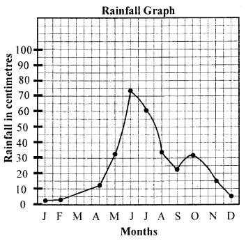
Question 8.
Prepare the rainfall graph of the data given below and answer the questions that follow :
ICSE Solutions for Class 9 Geography Chapter 20 Natural Regions of the World 3

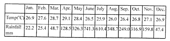
(a) What is the average annual temperature ?
(b) Calculate the annual range of temperature.
(c) In which climate type is this station ?

Answer:

(a) Average annual temperature is 27.2°C. (26.9 + 27.6 + 28.7 + 29.1 + 28.4 + 26.5 + 25.9 + 26.0 + 26.4 + 26.8 + 27.1 + 26.9) ÷ 12 = 326.3 ÷ 12 = 27.2
(b) Range of temperature is 3.2° C. 29.1 – 25.9 = 3.2
(c) The climatic type is equatorial climate.

ICSE Solutions for Class 9 Geography Chapter 20 Natural Regions of the World 1

ICSE Solutions for Class 9 Geography Chapter 20 Natural Regions of the World 2

Practice Questions (Solved)

Question 1.
What do you understand by a ‘natural resource’ ?
Answer:
The things that we and other living organisms (plants and animals) required for living and provided as natural gifts are called natural resources.

Question 2.
How many kinds of natural resources are available ? Name them.
Answer:
There are two types of natural resources i.e. Renewable resources and Non-renewable resources. These are air, water, plants, sunlight which are renewable, some are soil, minerals which are Non-renewable in case of reckless exploitation.

Question 3.
What are the various uses of wood ?
Answer:
The wood is one of the most important resource, as it provides timber for houses, construction, fuel for household and industrial purposes, transport lines, agricultural implements, furniture, sports goods, stationery and various consumer goods.

Question 4.
Why are coal and petroleum called fossil fuels ?
Answer:
The coal is formed by compression of carboniferous age forests between impervious sedimentary rock-folds and the petroleum is the stored ‘body oil of dinosaurs of Jurassic period in between the impervious rocks within the poses of shale rocks. So these are called the fossil fuels on account of being buried within the rocks like the fossils for a long period under the pressure of tectonic forces.

Question 5.
What are the benefits of non-conventional sources of energy?
Answer:
Non-conventional sources of energy are solar, geothermal, tidal energies. These are perennial sources i.e. non-exhaustible or renewable resources which can be obtained for ever and are also pollution-free. Although the establishment and apparatus of these sources is quite costly, but their returns are life – long.

Question 6.
What is the difference between sea water and fresh water?
Answer:
Sea water is saline in which the percentage of salinity is 3.5% i.e. 35 (35 per thousand) but the fresh water is not saline and can be used for drinking, household and industrial purposes.

Question 7.
What is the total percentage of fresh water on the earth?
Answer:
Out of 100% Water bodies on the earth 97% is occupied by the oceans, and only 3% is comprised by fresh water, again out of this 2% is occupied by snow lands and only 1 % is taken by fresh water bodies e.g. ponds, lakes, rivers etc.

Question 8.
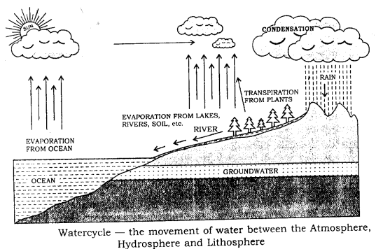
What is hydro logical cycle ?
Answer:
The water of ocean is evaporated in large amount into the atmosphere and then condensed into the clouds, fog, mist etc. After the dew point arises, precipitation takes place and fill up the fresh water bodies of the land surface. Again the water flow goes into the ocean and in this way a complete hydro logical cycle works on the earth. This is beneficial for the life on the earth, as fresh water is provided for agriculture and other occupations.

Question 9.
What gases does air contain ?
Answer:
Air mainly contains oxygen and nitrogen. Carbon dioxide and argon are also found in air.

Question 10.
Name the gases that are found in air along with their percentage.
Answer:
Oxygen 21 %, Nitrogen 78%, Argon 0.9%, others 0.1 %

Question 11.
Why is oxygen essential ?
Answer:
Oxygen is essential as it supports respiration making life possible on the earth.

Question 12.
How is carbon dioxide useful ?
Answer:
Carbon dioxide in the air is used by plants to produce food and oxygen.

Question 13.
How does an air conditioner help ?
Answer:
An air conditioner keeps the temperature and moisture of the air in a room at comfortable levels (usually between 20° and 25° C and a relative humidity of 35 – 70%).

Question 14.
name five resources which we get from the earth.
Answer:
Soil, minerals, coal, petroleum and plants.

Question 15.
What does subsoil contain ?
Answer:
Humus, rocks and minerals.

Question 16.
What are minerals ? List any four minerals.
Answer:
Minerals are inorganic substances obtained from Earth through the process of mining. Coal, manganese, iron ore and gold.

Question 17.
What type of resources are minerals ?
Answer:
Minerals are non-renewable natural resources which means that once mined, their deposits are depleted and lost forever without any chance of replenishment.

Question 18.
How do forests retain water ?
Answer:
Forests absorb rainwater and only gradually release it into rivers.

Question 19.
What is meant by deforestation ?
Answer:
Deforestation means cutting down and clearing of tree covers from forest areas to get land for agricultural use, cattle grazing . or exporting timber.

Question 20.
What happens when fossil fuels are burnt ?
Answer:
When fossil fuels are burnt they cause air pollution. Greenhouse gases are formed and acid rain may also fall.

Question 21.
List the inexhaustible sources of energy.
Answer:
Solar, hydel, tidal, wind and nuclear energy.

Question 22.
Which places in India can be used for tidal power generation ?
Answer:
Gulf of Cambay, Gulf of Kutch, Sunderbans and other coastal areas.

Question 23.
How many biogas plants have been set up in India under the National Biogas Development Programme ?
Answer:
15 lakh biogas plants.

Question 24.
What is geothermal energy ? Give examples of geothermal energy.
Answer:
It is the conversion of natural heat from the interior of the Earth to heat buildings and generate electricity. Volcanoes and natural springs.

Question 25.
How is ground water formed ?
Answer:
Water falls on earth in form of rain. The water from rainfall which reaches land percolates into the soil to reach deep down. Then it becomes a part of ground water.

Question 26.
List the advantages and disadvantages of solar energy.
Answer:
Solar energy can be gained by using a solar cell, a device that produces electricity directly from sunlight. By using special mirrors that focus the sunlight from a large area to a small area, solar-energy can be utilized for boiling water or for creating steam for producing electricity. The same collected solar energy can be localized into a solar furnace to heat oil. This process is used to boil water that drives turbines which produce electricity. Solar energy can be utilized to get drinking water from salty water sources. Salty water can be boiled and collected in form of steam. Salt, left behind is removed, and the steam gets cooler to turn back into water. Solar energy is used in desalination plant for this purpose. Photovoltaic cells have been used to electrify remote villages in rural Rajasthan, Uttar Pradesh, Gujarat and Haryana.
Solar energy has some disadvantages also, like the availability of sunlight only in daytime, lack of efficiency on a cloudy or rainy day, and feasibility only in countries located in regions which receive direct rays of the sun for a number of months in a year.

Question 27.
What is hydrological cycle ?
Answer:
Radiation from the sun causes water to evaporate from the water bodies in the form of water vapour. From plants, water continues to evaporate into air. This is done through the process of transpiration. Some water vapour is also retained by air. When the water vapour in the air rises up it combines to form clouds. In the clouds, there is moisture, i.e. water, which may fall on earth in form of rain, hail or snow. Some rain water that falls to the ground gets absorbed by the soil to form underground water.
The remaining water reaches the water bodies (river, ponds, lakes and oceans). This is the hydrological or water cycle that continues in nature all the time.

Question 28.
What is the aim of dividing the world into natural regions?
Answer:
The aim of dividing the world into natural regions is to study the variations in natural environment and its impact on human life in different parts of the world.

Question 29.
What forms the basis of a general scheme of natural regions of the world ?
Answer:
The latitudinal location and extent of an area forms the basis of a general scheme of natural regions.

Question 30.
Mention the regions that cover the following :

(a) Tropical Regions
(b) Warm Temperate Regions
(c) Cool Temperate Regions
(d) Polar Regions.

Answer:
(a) Tropical regions cover :

  1. Equatorial region
  2. Tropical grassland (savanna)
  3. Tropical desert
  4. Tropical east margin.

(b) Warm temperate regions cover :

  1. Mediterranean region
  2. China type
  3. Continental interior

(c) Cool temperate regions cover :

  1. Cool temperate west margin
  2. Temperate grasslands
  3. Cool temperate east margin
  4. Cool temperate (Taiga)

(d) Polar regions :

  1. Tundra (Cold desert)
  2. Ice caps

Question 31.
Where does the tropical region lie ?
Answer:
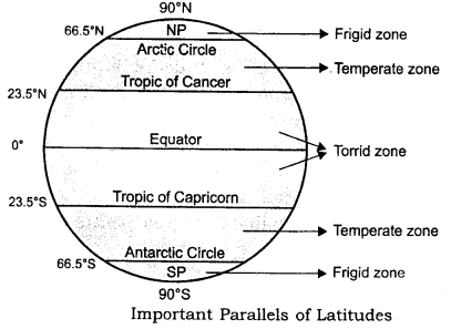
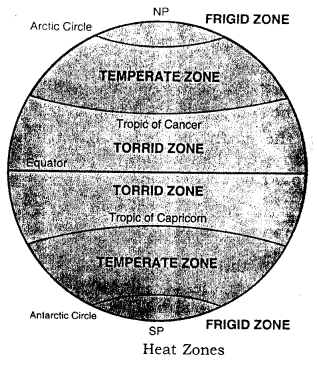
Tropical region lies roughly between 30°N and 30°S latitudes.

Question 32.
Where does the warm temperate region lie ?
Answer:
The warm temperate region lies between 30°North and South and 45° North and South of the Equator.

Question 33.
Where does the cool temperate region lie ?
Answer:
The cool temperate region lies roughly between 45° North and 65° North as well as between 45° South and 65° South latitudes.

Question 34.
Where does the polar region lie ?
Answer:
Polar region lies beyond 65° latitude (i.e., beyond Arctic and the Antarctic circles) and the Pole in each hemisphere.

Question 35.
Name the continents where the equatorial regions are situated.
Answer:
The continents where the equatorial regions are situated are – South America, Africa and Asia.

Question 36.
Which parts of Asia and S. America included in equatorial forest region.
Answer:
Equatorial region in Asia includes :

  • Indonesia
  • Malaysia
  • Irian Jaya
  • Papua New Guinea and
  • The southern islands of Philippines

Equatorial region in South America includes :

  • The Amazon basin
  • The coastal lowlands between the Guyana and Brazilian highlands.
  • The coastal part of Columbia.

Question 37.
Name the areas constituting the equatorial region in Africa.
Answer:
The areas constituting the equatorial region in Africa are :

  1. The Congo basin
  2. The coast of Guinea
  3. Southern parts of Nigeria and Ghana.

Question 38.
What are the chief features of the climate of equatorial regions ?
Answer:
Chief features of climate of equatorial region are :

  1. It receives a large amount of insolation.
  2. Relative humidity remains high throughout the year.
  3. Almost equal days and nights throughout the year.
  4. Little seasonal variation in the climatic conditions because of vertical sun rays all the year round.
  5. Climate is not unbearable because of cloudiness and heavy rainfall.

Question 39.
Mention the major trees found in equatorial forests.
Answer:
Major trees of equatorial forests are :
Mahogany, Ebony, Ivory wood, Dye wood, Cinchona and Rose wood.

Question 40.
Name any four countries which have monsoon climate.
Answer:
India, Pakistan, Bangladesh, Myanmar, etc. have monsoon climate.

Question 41.
Mention the location of Tropical monsoon type regions.
Answer:
Monsoon type regions are located in the zone extending between 5° and 30° latitudes on either side of the Equator.

Question 42.
What is the range of temperature in monsoon region in the interior of the continent.
Answer:
Summer temperature varies from 35°C to 38°C in the interior. Winter temperature varies from 15°C to 18°C in the interior.

Question 43.
Why is there complete reversal of pressure gradients over Asiatic landmass ?
Answer:
There is complete reversal of pressure gradients over Asiatic landmass because of north wards and southwards migration of the Sun and consequent differential heating of the continent and adjoining areas.

Question 44.
Name any two states of India which receive winter rainfall.
Answer:
The eastern coast of Tamil Nadu and Andhra Pradesh receives much rainfall during winter season through north-east monsoons.

Question 45.
What is the location of tropical desert ?
Answer:
Tropical deserts are located on the western coasts of the continents between the latitudes of 15° and 30° north and south in the belt of the trade winds.
They are found in both the hemispheres pole ward of the tropical grasslands.

Question 46.
Name the parts that Sahara desert covers.
Answer:
Sahara desert covers :

(a) Parts of Algeria
(b) Libya
(c) UAR (Egypt)
(d) Sudan
(e) Mali
(f) Niger and Chad.

Question 47.
Where are the following deserts located ?

(a) Arabian desert
(b) Thar desert
(c) Kalahari desert
(d) Atacama desert

Answer:

(a) Arabian desert is to the east of Red sea.
(b) Thar desert is in the Indian subcontinent.
(c) Kalahari desert is in southern parts of Africa.
(d) Atacama desert is in South America extending along the Pacific coast to the west of the Andes mountains.

Question 48.
Mention the two features of the climate of tropical desert.
Answer:
The two features of the climate of tropical desert are :

  1. Dry and hot
  2. Aridity is the most outstanding feature of these deserts.

Question 49.
State the vegetation of deserts.
Answer:
Vegetation of deserts :

  1. Cacti, thorny scrub and wiry grass, herbs, weed.
  2. The vegetation may not appear green and fresh all the time.
  3. Vegetation consist of entirely drought resisting plants – Xerophytes.
  4. Dwarf trees like acacia are found.
  5. Date palms are found near the oases.

Question 50.
Why are the deserts sparsely populated ?
Answer:
The deserts are sparsely populated because of the shortage of food and water.

Question 51.
Name the typical animal of desert region.
Answer:
Camel is the typical animal of desert region as it is especially well-adapted to the arid environment.

Question 52.
What is the location of Mediterranean region ?
Answer:
Mediterranean region is located on the western margins of the continents between 30 ° and 45 ° latitudes in both hemispheres.
It lies between the tropical deserts and cool temperate areas.

Question 53.
Mention the extent of Mediterranean type climate in the following :

(a) Asia
(b) Europe
(c) Africa
(d) America
(e) Australia

Answer:
Extent of Mediterranean type of climate is as follows :
(a) Asia includes :

  1. Turkey
  2. Syria
  3. Lebanon and Israel

(b) Europe includes :

  1. Spain
  2. Portugal
  3. Southern France
  4. Italy and Greece

(c) Africa includes :

  1. North-west Algeria
  2. Tunisia
  3. Morocco
  4. Egypt and Southern Strip of South Africa.

(d) North America includes west coast of USA (a large part of California)
(e) Australia includes :

  1. Southern and South-Western region
  2. North Island of New Zealand.

Question 54.
What are the general characteristics of the climate of Mediterranean region ?
Answer:
General characteristics of the climate of Mediterranean region are :

  1. A warm dry summer and a cool wet winter.
  2. It receive moderate amount of precipitation.
  3. Low humidity.
  4. It experience many local winds-hot and cold.

Question 55.
Name the winds prevailing during summers and winter in Mediterranean region.
Answer:
During summer trade winds blow upto about 45° N latitude in the Northern Hemisphere. In winter the prevailing winds are westerlies and reach the western coasts of the continents as onshore winds. Being moist these winds cause rainfall in winter season.

Question 56.
What are the characteristics of the Mediterranean climate which makes it suitable for orchard farming ? Which state of USA is famous for orchard farming ?
Answer:
The Mediterranean lands are the well known orchard lands of the world. The mild rainy winters and abundant sunshine, even in winter, have made these regions very suitable for fruit growing. The state of California is famous for orchard farming.

Question 57.
Which country is the world’s leading producer of grapes?
Answer:
Italy is the world’s leading producer of grapes.

Question 58.
Why is the Mediterranean region popular for fruit processing industry ?
Answer:
The easy availability of fruit as a raw material leads the development of fruit processing industry. The popularity of viticulture witnessed a revolution in the manufacturing industry especially in the production of wines.

Question 59.
Why Mediterranean region cannot support large cattle populations ?
Answer:
Climate conditions in the Mediterranean region do not favour grasses because most of the rain occurs in cool season when the growth is slow. The only grasses that can grow in these regions are so wiry and bunchy that they cannot support large cattle populations.

Question 60.
During which season Mediterranean region receives most of its rainfall.
Answer:
Mediterranean region receives most of the rainfall in winter season.

Question 61.
Give the important evergreen coniferous trees of Mediterranean region.
Answer:
Evergreen coniferous trees of Mediterranean region are :

  1. Pines
  2. Firs
  3. Cedars
  4. Cypresses.

Question 62.
For what is California famous and why ?
Answer:
California is famous for orchard farming. It is because of its climate, long frost free growing season and fertile alluvial soils. Moreover there are many irrigation projects which provide plentiful supply of water to the farm lands.

Question 63.
Mention three special cultures of Mediterranean region.
Answer:
Three special cultures of Mediterranean region are :

  1. Sericulture
  2. Horticulture
  3. Viticulture.

Question 64.
What is Viticulture ? Why is it so popular in Europe ?
Answer:
The cultivation of grapes is known as viticulture. This fruit is used for making wines of various brands and kinds. It is very popular in Europe because of its availability.

Question 65.
By what names are the grasslands known in following areas :

(a) In North America
(b) In South Africa
(c) In Hungary
(d) In Eurasia
(e) In Australia.

Answer:
The grasslands are known by different names in different areas :

(a) In North America as Prairies
(b) In South Africa as Veld
(c) In Hungary as Pastaz
(d) In Eurasia as Steppes
(e) In Australia as Downs.

Question 66.
Give the extent of steppes.
Answer:
Steppes extends from the east shore of the Black sea and Caspian sea to the Loess highland of north-west China, including the plain of Manchurian and Russian Turkestan.

Question 67.
What kind of climate does Steppe has ?
Answer:
It has continental climate. Extreme summer and winter temperatures.

  • In Northern Hemisphere because of distance from sea summers are warm, winters are cold.
  • In Southern Hemisphere climate is never severe. It is moderate because of nearness to sea.

Question 68.
What is the mean annual rainfall in Steppe region ?
Answer:
Mean annual rainfall in Steppe region is between 25 cm to 75 cm.

Question 69.
What is the extension of prairies ?
Answer:
Prairies extend from the Great Lakes to the Rocky mountains in Canada and the United States.

Question 70.
What is the average temperature and rainfall in prairies?
Answer:
The average temperature is 16°C and rainfall ranges between 50 and 75 cm.

Question 71.
Give the location of China type climate region.
Answer:
China type climatic region is located between 20° and 40° latitude in both the hemispheres along the eastern parts of the continents.

Question 72.
By which currents are the coastal parts of China type of climate affected ?
Answer:
The coastal parts of China type of climate are affected by the warm currents.

Question 73.
What are typhoons ?
Answer:
Typhoons are tropical cyclones which occur in China sea.

Question 74.
Give two characteristics of vegetation of China type climate.
Answer:
Dense forests of evergreen nature are found in more humid areas but areas of moderate rainfall are characterized by deciduous sparse forests and grasslands.

Question 75.
In which parts of Africa do tropical grasslands occur ?
Answer:
In the continent of Africa, the tropical grasslands are the most extensive, covering a belt around the Equatorial region in both the hemispheres.

Question 76.
What is known as ‘Parkland’ ?
Answer:
Some parts of tropical grasslands are known as ‘Parkland’ because there are clusters of trees, especially along river valleys and on the margins of the Equatorial region.

Question 77.
Why is the Taiga known as the Cold Pole of the Earth’?
Answer:
Taiga is known as the ‘Cold Pole of the Earth’ because Verkhoyansk (-68° C), the ‘Cold Pole’ of the world is located in this region in Eastern Siberia. It is a basin where the cold air stagnates for many weeks. It has the distinction of being the coldest place in the world.

Question 78.
Why is Polar Tundra region called the cold desert ?
Answer:
The Polar Tundra region is called the cold desert because the annual rainfall is less than 25 cm.

Give reasons for the following

Question 79.
There is little seasonal variation in the climatic condition of equatorial region.
Answer:
Due to almost vertical sun rays all the year round, there is little seasonal variation in the climatic conditions.

Question 80.
Equatorial regions support luxuriant vegetation.
Answer:
Equatorial regions support luxuriant vegetation because of high temperature and abundant rainfall.

Question 81.
Nights in the deserts are very cold.
Answer:
Temperature remains some what lower due to the influence of cold currents during night. Clear skies also cause a rapid cooling of the land at night.

Question 82.
Camel is called the ship of the desert.
Answer:
Camel is called the ship of desert because it has,adapted itself to the harsh environment of the desert in the following ways :

  1. Its long legs with padded feet enable it to move fast over sand.
  2. It can store water in its body for a number of days.
  3. Its hump stores energy in the form of fat on which it can survive during times of starvation.
  4. It is capable of picking very small leaves from even thorny bushes.
  5. It has good capacity to carry loads.

Question 83.
Mediterranean regions receive most of their precipitation in winter season.
Answer:
In winter the prevailing winds are westerlies and they reach the western coasts of the continents as onshore winds. Being moist they cause precipitation on the western margin of the continents.

Question 84.
Climate conditions in the Mediterranean region do not favour grasses.
Answer:
Climatic conditions in the Mediterranean region do not favour grasses because most of the rain occurs in cool season when the growth is slow.

Question 85.
Agriculture is the main occupation of the people in most parts of the Mediterranean lands.
Answer:
Agriculture is the main occupation of the people in Mediterranean region. Long growing season, long hours of bright sunshine, the high temperature of summer, mid moist winters and fertile soils, in many areas, are favorable conditions for the growth of certain crops.

Question 86.
Grasslands are treeless.
Answer:
Grasslands are treeless because the porous soil and low rainfall mostly in summer. High evaporation and swift winds check the growth of trees in these regions.

Question 87.
The Steppe climate of the southern hemisphere is never severe rather it is moderate.
Answer:
The Steppe climate of the southern hemisphere is never severe rather it is moderate because of nearness to the sea.

Question 88.
The western margins of continents are extremely dry.
Answer:
The western margins of continents are extremely dry because the trade winds blow from the interior of continents as offshore winds.

Differentiate between the following 

Question 89.
Humid regions and Sub-humid regions.
Answer:
Humid regions :

  1. Humid regions receive more precipitation than the evaporation all the year round.
  2. These regions face no water deficiency in the dry season.

Sub-humid regions :

  1. In a sub-humid regions the precipitation exceeds evaporation only during the short rainy season.
  2. These regions face water deficiency in the dry season.

Question 90.
Humid regions and Arid regions.
Answer:
Humid regions :

  1. Humid regions receive more precipitation than the evaporation all the year round.
  2. No water scarcity.

Arid regions :

  1. Arid regions precipitation is lower than the precipitation whole year.
  2. Water scarcity throughout the year.

Question 91.
Warm temperate region and Cool temperate region.
Answer:
Warm temperate region :

  1. It extends from 30° N to 45° N latitudes in each hemisphere.
  2. It includes Mediterranean type, tropical desert type and monsoon type climatic region.

Cool temperate region :

  1. It extends from 45° N latitudes in each hemisphere.
  2. It includes west-European type, temperate grasslands, St. Lawrence type and Taiga type climatic region.

Question 92.
Sericulture and Viticulture.
Answer:
Sericulture :

  1. Sericulture refers to the rearing of silk worms.
  2. It is for. the production of raw silk. Leading producers are Northern Italy, Southern France and Parts of Spain.

Viticulture :

  1. Viticulture refers to growing of grapes on a large scale.
  2. It is for the production of wine. Leading producers are Italy, France, Spain and Portugal.

Question 93.
Truck farming and orchard farming.
Answer:
Truck farming :

  1. The American farmers call ‘market gardening’as truck farming because they send fruits and vegetables daily to the markets by means of truck
  2. Climatic condition is not an important factor in truck farming.

Orchard farming :

  1. Mediterranean lands are the well-known orchard lands of the world. Orchard farming is concerned with growing of fruits on large scale.
  2. Climatic condition is the main factor in orchard farming so lots of care is needed at every stage.

Question 94.
Evergreen and Xerophytic trees of Mediterranean region.
Answer:
Evergreen trees :

  1. Evergreen trees of Mediterranean region have no regular season for shedding their leaves.
  2. They have needle shaped leaves.
  3. Pines, firs, cedars and cypresses are the main evergreen trees of this region.

Xerophytic trees :

  1. Xerophytic trees of Mediterranean region they adapt themselves to the dry summer.
  2. They have small, stiff, shiny leaves, thorns and long roots and waxy surface.
  3. The vine (with long roots) laurel (with leathery leaves), cork oak with thick spongy bark are some examples of this region.

Question 95.
Role of trade winds and westerlies in Mediterranean region.
Answer:
Role of trade winds in Mediterranean region :

  1. Trade winds prevail during summer.
  2. These blow up to about 45° latitude.
  3. These blow from an easterly quarter and become dry by the time they reach the western margins of the continents, cause no rainfall.

Role of westerlies in Mediterranean region :

  1. Westerlies prevail during winter season.
  2. These blow between 30° N latitudes.
  3. These reach the western coasts as onshore winds. Being moist they cause precipitation on the western margin of the continents.

Question 96.
Steppes and Prairies.
Answer:
Steppes :

  1. The grasslands in Eurasia are known as Steppes.
  2. The Steppes of Eurasia occur on either side of the Ural mountains covering the parts of Eastern Europe and Western Siberia in Asia.

Prairies :

  1. The grasslands in North America are known as Prairies.
  2. Prairies of North America lie between the Rockies and the Great Lakes of North America.

Question 97.
Define Mangrove forest.
Answer:
Mangrove forest: These forests are found in the coastal areas and brackish swamps. The number of plant species found in any area in these forests are very large.

Question 98.
Define Shifting cultivation
Answer:
Shifting cultivation : It is a migratory system of agriculture. In this system, at first the small trees of an area are cut by a long thick bladed knife then, the slash is burnt, and crops are planted among the stumps by dropping the seeds into holes, made with a pointed stick.

Question 99.
Define Oases
Answer:
Oases : Oases are the areas in the deserts where some water is available. They are centers of greenery in the otherwise dreary expanse of the desert.

Question 100.
Define Sericulture
Answer:
Sericulture : It is an art of raising the silkworms and production of raw silk. Northern Italy, Southern France and parts of Spain are leading produces of silk in Europe.

Long Answer Questions

Question 101.

(a) Give a brief account of climate of the Equatorial region.
(b) Explain briefly the importance of Equatorial forests.
(c) Why are Equatorial forests not commercially important?

Answer:
(a) The Equatorial region is characterized by uniform high temperature and heavy rainfall throughout the year. This is why there is little seasonal variation in climatic conditions in this region.

  1. This kind of climatic condition is due to the high angle of incidence of the Sun’s rays. The angle of incidence varies only between 66 V2° and 90° during the year.
  2. Temperature ranges between 25° C and 30° C with an annual range of about 2° C.
  3. Rainfall is well distributed during all the months of the year. The amount ranges from 150 cm to 350 cm or more. Rainfall is of Convectional origin. The intense heating of the atmosphere due to solar radiation causes convectional ascent of air leading to cooling of air condensation, formation of clouds and rainfall in the afternoon. But the mountain regions experience Orographic rainfall.
  4. Thus the equatorial region has the combination of high temperature and high humidity but the climate is not unbearable because of cloudiness and heavy rainfall.

(b) Equatorial forests are important in many ways as :

  1. They are very vital for our environment because they absorb a large amount of carbon dioxide from the atmosphere and exhale huge amount of oxygen. Hence they are known as the ‘Lungs of the world’.
  2. They maintain the ecological balance so their destruction will adversely affect the ozone layer and cause a great harm to living beings.
  3. They are the source of numerous medicinal plants and herbs, e.g., Quinine is obtained from cinchona tree growing in these forests.
  4. They are a source of valuable hard wood timber like Mahogany, Ebony, Ironwood, Rosewood, etc.

(c) Equatorial forests are not commercially important because of the following reasons :

  1. Equatorial forests are dense and have a large number of varieties of trees in mixed strands. Pure strands of trees are not found as in the coniferous forests.
  2. Valuable species are found scattered over a large area.
  3. The ground in damp and slushy and the construction of roads, railway line is difficult.
  4. The climate is also oppressive due to high temperature, high humidity and heavy rainfall.

Question 102.
Explain the monsoon climate type region under the following heads :

(a) Temperature
(b) Air pressure and winds
(c) Vegetation
(d) Three seasons of Indian subcontinent.

Answer:
Monsoon climate type region under :
(a) Temperature : In summer, when the Sun is overhead on the Tropic of Cancer, the Northern Hemisphere is intensely heated. Summer temperature varies from 27°C to 30° C in the coastal areas and 35° C to 38° C in the interior.

  1. In winter, the Sun is overhead on the Tropic of Capricorn. Temperature varies from 22° C to 25° C in the coastal areas and 15° C to 18° C in the interior.
  2. In some northern parts of India the temperature during May and June becomes exceptionally high due to prevalence of hot winds locally known as loo.

(b) Air pressure and winds.

  1. (i) The low pressure is strong enough to attract the moisture bearing winds from the Indian ocean.
  2. (ii) The South East Trade winds from the Southern Hemisphere are drawn into India as the South-West monsoon winds after they cross the Equator.
  3. (iii) Monsoon areas are affected by high and low pressure systems due to winter and summer seasons respectively.
  4. (iv) There is complete reversal of pressure gradients over Asiatic landmass.

(c) Vegetation. Important trees :

  1. Sal
  2. Teak
  3. Bamboo
  4. Mahua
  5. Jamun
  6. Neem
  7. Shisham, etc.

Trees are normally deciduous because of the marked dry season during which they shed their leaves to withstand the drought.
Forests are more open, less luxuriant. Tidal forests grow in Delta plains and along the coasts. The Sunderbans of Ganga – Brahamputra delta are famous mangrove forests.
(d) There are three main seasons in a year in Indian sub continent.

  1. The hot, dry season is from March to mid June. During this period temperature is very high. Sun’s apparent movement is northwards to Tropic of Cancer. Relative humidity is low. Coastal region experiences some relief from the intense heat due to the moderating influence of the sea. Dust storms are very common in the northern region.
  2. Humid warm summer season is also known as the rainy season which is from July to October. The maximum rainfall is concentrated in these months. Due to rains the temperature is considerably low.
  3. Dry winter season from November to February. During this period North-East monsoon prevails. Winds are dry but over the Bay of Bengal they pick up moisture which is deposited in south-east Indian peninsula.

Question 103.

(a) Elaborate the special features of vegetation in hot desert region.
(b) What is the mode of rainfall in hot desert region.

Answer:
(a) The hot deserts are not good for vegetation due to climatic conditions. The rainfall is too scanty to support a vegetable cover. Therefore a lot of bare ground on desert land.

  1. The type of vegetation growing here consists of thorny scrubs like cactus, prickly pear and other plants which are adapted to survive in a region of low rainfall. These are called Xerophytic plants.
  2. Some species have thick leathery leaves, some are leafless while some plants have a repugnant smell so that they are not eaten by animals.
  3. Cacti are the most typical plants of the deserts. The Saguaro Cactus in the Arizona Desert (USA) is the famous cactus.
  4. The date palm grows best only in hot deserts as it requires plenty of sunshine and sandy soil. Date palms are grown near the oases where under ground water occurs near the surface.

(b) The hot deserts receive less than 25 cm of annual rainfall, on the average, but many places do not get even this because the hot deserts are located on western margins of continents and in the belt of Trade Winds. The trade winds become drier because the moisture gets precipitated on the eastern margins. The western margins are extremely dry because the Trade winds are blown from the interior of continents as offshore winds. The trade winds blow from cooler higher latitudes to warmer lower latitudes. Hence the winds gets warmed up and the possibility of rainfall is reduced. Rainfall occurs as torrential downpours associated with violent thunderstorms due to convectional ascent of air.

Question 104.
The Mediterranean land is known as the ‘Land of Orchards’. In this context answer the questions that follow :

(a) The characteristics of Mediterranean climate.
(b) How is it suitable for orchard farming ?

Answer:
(a) Characteristics of Mediterranean climate are as follows : These regions lie between the Tropical Deserts on the equatorward and cool temperate west margin region polewards. So the Mediterranean regions are characterised by warm, dry summer and cool wet winters.

  1. It receives a moderate amount of precipitation as it is transitional between the arid and the humid regions.
  2. The coastal regions are cooler than the interior ones due to the influence of cool ocean currents.
  3. The humidity is low so the heat of the day is not felt oppressive.
  4. The Mediterranean regions experience moderate rainfall only in winter and drought in summer. The annual rainfall varies from about 35 cm to 75 cm.
  5. During the summer season, the North-East and South-East Trade winds prevail over this region. As these offshore winds are hot and dry, they blow dust from the adjoining desert regions.
  6. During the winter season, this region is under the influence of the moist Westerlies blowing from the oceans. It gives much rainfall.
  7. It experiences many local winds – hot and cold. The southern shores of Mediterranean sea are affected by hot and dry winds, called the Sirocco, which blow from the Sahara desert and carry a large amount of dust. The high temperature of the wind damages vine yards, olive trees and vegetable crops.
  8. The hot and dry wind is known by many local names such as Khamsin in Egypt, Leveche in Spain and Santa Ana in California
  9. Cold local winds called the Mistral descend from the Alpine range during the winter season and blow with great force which damage cultivated crops and trees.
  10. A similar type of cold wind, called Bora, often causes devastation.
  11. Clear sky and sunshine are common almost throughout the year.
  12. Snowfall is very rare in this region except on mountains.

(b) Mediterranean land is suitable for orchard farming because of suitable climate. Orchard farming is important on the slopes which are not suitable for the cultivation of food crops. Fruit orchards cover large areas of hill slopes as citrus fruits trees have a deep root system to tap underground water. The climatic conditions of this region, the warm sunny summer, helps in ripening them. The mild rainy winters and abundant sunshine, even in winter have made these regions Very suitable for fruit growing. The dry season favour the harvest. Moisture deficiencies are avoided through good network of canals.
Some of the common citrus fruits are orange, lemon, lime and grape fruit. Other varieties are olives, grapes, peach, pear, plum, pomegranate, apricot and fig. Chestnut walnut, hazelnut and almond are also grown. Because of large scale fruit growing Mediterranean lands are the orchards of the world.


ICSE Solutions for Class 9 Geography – Earth As a Planet

ICSE Solutions for Class 9 Geography – Earth As a Planet

ICSE SolutionsSelina ICSE SolutionsML Aggarwal Solutions

Exercises

I. Short Answer Questions

Question 1.
How can you prove that the earth is a sphere by looking at the Pole Star ?
Answer:
The Pole Star can be seen at an angle of 90° at the North Pole, as it lies directly at the line of axis of the earth, while its angle decreases towards the Equator i.e. it is 0° at the equator. It is only possible in an quarter arc of a circle. It proves that the earth is a sphere with circular surface.

Question 2.
Briefly describe the shape of the earth.
Answer:
The earth has got a spherical shape, slightly bulging at the equator and flattened at the poles. The spherical shape is confirmed by the arrival of a ship seen first by its mast and later on the ship. The satellite picture of the earth, shadow of the earth on the moon as circular, and the views of circular horizons from the height etc. all these prove the spherical shape of the earth.

Question 3.
What is the earth’s mean temperature ? State its one advantage.
Answer:
The earth’s mean temperature is 17° C, which is ideal to support the survival of the life-system.

Question 4.
Why is the earth called a watery planet ?
Answer:
The earth is called a watery planet, as its major part i.e. 70% is covered by water or hydrosphere. The earth is seen blue in the satellite pictures due to the majority of water.

Question 5.
What is ‘biosphere’ ?
Answer:
Biosphere is the narrow zone of contact amidst lithosphere, hydrosphere and atmosphere.

Question 6.
Name the conditions necessary for life on earth.
Answer:
The conditions necessary for life on earth, are ideal temperature range with an average between 10°C and 35°C, solar radiation, humidity, wind, water, land etc.

Question 7.
Give any two features of the earth that make it a ‘Unique Planet’.
Answer:
The earth is so for the only planet which consists of life- system. It is due to its ideal average temperature of 17°C to support the life and provide with atmosphere and hydrosphere to impart air and water essential for life.

Question 8.
Why is the planet Venus hotter than the planet Mercury?
Answer:
Venus is hotter than Mercury because the atmosphere around Venus is mainly composed of carbon dioxide. The carbon dioxide produces Greenhouse effect on the surface of Venus. Thus, the tempreature on its surface remain very high.

Question 9.
Name the two sources of heat in the interior of the earth.
Answer:
Two sources of heat in the interior of the earth are the radioactive elements trapped inside and the immense temperature and pressure in the deep interior.

Question 10.
What is meant by Terrestrial Life ?
Answer:
On the surface of the earth, there are continents and oceans. The life on the continents or on land is called ‘Terrestrial Life’.

Question 11.
Name the members of the Solar System.
Answer:
Members of the solar system includes the Sun and everything that orbits it like planets (Mercury, Venus, Earth, Mars, Jupiter, Saturn,.Uranus and Neptune), their satellites, asteroids, comets, interplanetary gas and dust.

Question 12.
What is a planet ?
Answer:
A planet is a rocky or gaseous mass that revolves around a star.

Question 13.
What is meant by Inner Planets ? Name them.
Answer:
The planets that lie within the asteroid belt that is Mercury, Venus, Earth and Mars are called the inner planets.

Question 14.
Why are the inner planets called the terrestrial planets?
Answer:
The inner planets are called the terrestrial planets because their structure is similar to that of the earth.

Question 15.
What are Jovian planets ? Name them.
Answer:
The planets whose structure is similar to that of Jupiter are – called Jovian planets. They have ring systems around and have a large number of moons. They are of gaseous origin. Saturn, Uranus and Neptune are Jovian planets.

Question 16.
How big is the sun ? Describe its size with respect to the earth.
Answer:
The sun is a star or a ball of hot gases. Its diameter is 1,392,000 km. i.e. 110 times larger than that of earth and its volume is 1.3 million times larger than the earth.

Question 17.
Distinguish the earth from the other planets in one important aspect.
Answer:
Our earth is also called a Tonely-planet’ because of its one important aspect having extensive life system.

Question 18.
How did the earth get its atmospheric blanket ?
Answer:
In the beginning, at the time of evolution of the planets, the earth was also a body of burning clouds of gases and dust. After cooling process, the heavy elements subsided downwards and the gases floated upwards and formed the atmosphere around the earth as a blanket.

II. Fill in the blanks

  1. The Pole Star can be seen at an angle of 90° at the North Pole.
  2. The earth rotates from west to east.
  3. Biosphere is the narrow zone of contact between lithosphere, hydrosphere and atmosphere.
  4. The earth has an average temperature of 17° C.
  5. Atmosphere is the major reservoir of carbon on the earth.
  6. In terms of size, the earth is fifth planet in the Solar System.
  7. Eratosthenes worked out the circumference of the earth to be 46,250 km.
  8. A typical galaxy may contain large cluster of stars.

III. Long Answer Questions

Question 1.
Study the picture and answer the questions that follow.

ICSE Solutions for Class 9 Geography Chapter 1 Earth As a Planet 1

(a) What does the picture show you about the earth ?
(b) State briefly the Bedford Level Experiment.
(c) The sun rises and sets at different times in different places. What does the statement show about the shape of the earth.
(d) In what way is the earth’s atmosphere beneficial to mankind ?

Answer:

(a) The picture shows the spherical shape of the earth.

(b) Three pillars of equal height were put along the Bedford Level canal area in England each at 5 kms. interval. After observation it came to know that the middle pole was higher than the sideward poles. This proved that the earth’s surface was curved and the earth is a spherical body.

(c) The times of sunset and sunrise are different in the different part of the earth, because the earth moves from west to east and the places situated in the east get sunrise first. Japan is called the land of rising sun, as it is in the eastern-most part of the Eastern Hemisphere and the date starts from the Eastern Hemisphere. It proves that the earth is spherical.

(d) The atmosphere is indispensable for life on earth, as it provides air to inhale ; rainfall and fresh waterbodies after the hydro logical cycle. Moreover, it absorbs the extremely hot ultraviolet rays of the sun and makes the temperature ideal on earth. Other planets are either very hot or very cold due to the absence of atmosphere.

Question 2.
Provide reliable evidence to prove that the earth is spherical in shape.
Answer:
The earth can be clearly seen spherical in the photographs from the satellite. Other proofs are the sight of the mast of a ship first before the ship appears, varying heights of the poles fired at different places at an interval of 5 km, through the Bedford Level Experiment and the sight of Pole Star at 90° from North Pole and the view of the earth’s horizon as circular from higher attitudes.

Question 3.
Give the distinctive features of the earth as a unique planet. Also give three points of comparison with respect to other planets.
Answer:
The earth possesses all the essential features necessary for maintaining the life-system. It is provided with atmosphere and hydrosphere along with the lithosphere. Moreover the average temperature of 17°C is ideal for survival. Three points of comparison with respect to other planets are as follows.

  1. Other planets are either too hot or too cold that are unfavourable for life.
  2. Other planets are devoid of atmosphere and hydrosphere and some are surrounded by poisonous gases.
  3. Other planets are devoid of fresh water bodies, like rivers and lakes.

Question 4.
Describe the role of each of the following in making earth a habitable planet.

(a) Atmosphere
(b) Water
(c) Temperature

Answer:

(a) Atmosphere — Atmosphere play very important role in making earth a habitant planet. Atmosphere plays following role:

  1. The atmosphere receives heat from the sun by solar radiation and loses heat by earth’s radiation. In this way a balance is maintained.
  2. The earth’s atmosphere is made up of life supporting gases like nitrogen, oxygen and carbon dioxide. Other gases include Helium and Aigon.
  3. Ozone present in the earth’s atmosphere absorbs the harmful ultraviolet rays of the sun.
  4. The atmosphere also prevents loss of heat from the earth’s surface and helps to keep the earth warm.

(b) Water — 70% of the earth’s surface is covered by water. Water plays following role :

  1. It is responsible for moderating the climate and surface condition of the earth.
  2. Water from seas, rivers and lakes evaporates into the atmosphere where it condenses and falls back as precipitation. Most of the water on land flows back to the oceans. Thus, water moves in a continuous cycle — the hydrological cycle. There is proper balance between evaporation, condensation and precipitation without which life would not be possible.
  3. Water can absorb enormous amounts of heat without causing much change in its temperature. During the day, waterbodies rapidly absorb enormous amount of heat : thus, the earth remains fairly cool. At night the waterbodies release vast amounts of heat that they absorbed during the day, which along with other atmospheric effects, keep most of the surface from freezing at night.

(c) Temperature — The earth is the third planet from the sun. It has an average temperature of 17°C which is suitable for life to exist. If the average temperature on the earth’s surface changes by only a few degrees, many species would perish due to extreme heat or cold.

Question 5.
Name the different realms of the earth.
Answer:
The different realms of the earth are lithosphere, hydrosphere and atmosphere.

Question 6.
Study the picture and answer the questions that follow.

ICSE Solutions for Class 9 Geography Chapter 1 Earth As a Planet 2

(a) What is meant by the Solar System ?
(b) Give two differences between a planet and a star.
(c) Name the planets known as terrestrial planets.
(d) Give two advantages the earth has over other planets.
(e) What are satellites ?

Answer:
(a) The sun along with eight planets and asteroids forms the Solar System.

(b)

  1. The stars like the sun radiate heat and light. Planets have no light of their own. They reflect the light of their stars.
  2. The stars are large burning masses very far from us while the planets are solid bodies nearer to us.

(c) The planets within the asteroids belt i.e. Mercury, Venus, Earth and Mars, are called the Terrestrial planets.

(d)

  1. The earth enjoys an ideal average temperature of 17°C
  2. The earth consists of the life-system.

(e) The satellites are the celestial bodies that revolve around the planets.

Question 7.
Write a short note on the planets of the Solar System. Name the planets in order of their distance from the sun.
Answer:
There are total eight planets included in the solar system which revolve around the sun in their particular elliptical tracks. According to their distance from the sun from near to far, these are Mercury, Venus, Earth, Mars, Jupiter, Saturn, Uranus and Neptune.

Question 8.
Distinguish between a planet and a star.
Answer:
A Planet :

  1. A planet revolves around a star
  2. A planet has not got its own light.
  3. A planet is a solid body.

A Star :

  1. A star remains still on its position.
  2. A star has got its own light.
  3. A star is a burning gaseous body.

Practice Questions (Solved)

Question 1.
In which unit the distances of universe are measured ?
Answer:
Light year.

Question 2.
How much time does a ray of sunlight take to reach the Earth ?
Answer:
8 minutes approximately.

Question 3.
How much time does a ray of moonlight take to reach the Earth ?
Answer:
One second approximately.

Question 4.
How many planets are there in the Solar System ?
Answer:
Eight

Question 5.
Name the largest planet of the Solar System.
Answer:
Jupiter.

Question 6.
Name the planet closest to the Sun.
Answer:
Mercury

Question 7.
Name the planet farthest from the Sun.
Answer:
Neptune.

Question 8.
What is position of the Earth from the Sun ?
Answer:
Third

Question 9.
Name the planets between the Sun and the earth.
Answer:
Mercury and Venus.

Question 10.
Which planet is known as ‘blue planet’ ?
Answer:
Earth

Question 11.
Which planet is known as ‘red planet’ ?
Answer:
Mars

Question 12.
Which is the brightest planet ?
Answer:
Venus

Question 13.
Which planet has the largest number of satellites ?
Answer:
Jupiter.

Question 14.
Which planet has only one satellite ?
Answer:
Earth

Question 15.
Which planet has three rings round it ?
Answer:
Saturn.

Question 16.
Which star is known as ‘Evening Star or “Morning Star” ?
Answer:
Venus

Question 17.
How many satellites are there in Solar System ?
Answer:
100 approximately.

Question 18.
Which is the centre of the Solar System-Sun or Earth?
Answer:
Sun

Question 19.
What is the period of rotation of Moon ?
Answer:
27 days 7 hours 43 minutes.

Question 20.
‘Although the Moon has no light of its own, yet it shines’. Why ?
Answer:
Sun’s light is reflected from the surface of the moon.

Question 21.
Mention two important features of Earth that make it a planet suitable for life.
Answer:

(a) Presence of atmosphere
(b) Presence of water

Short Answer Questions

Question 1.
State three unique features of the Earth.
Answer:
There unique features of earth are as follows :

  1. It is neither too hot nor too cold.
  2. It had atmosphere surrounding it.
  3. There is plenty of water on it.

Question 2.
State three factors which have made life possible on the Earth and on no other planet.
Answer:
The factors which have made life possible on earth and on no other planet are as follows :

  1. Earth is the only planet in the Solar System which is neither too hot nor too cold.
  2. The atmospheric blanket around the earth protects it from ultra-violet and other deadly sun rays.
  3. The mixture of gases in the atmosphere is suited to growth and survival of life.
  4. Plants, through the process of photosynthesis take away carbon dioxide from atmosphere and make oxygen available for animals to breathe.
  5. Oceans play a great supportive role. They cover three-fourths of earths surface and are responsible for operation of hydrological cycle which makes water on land surface available.
  6. Circulation of many life cycles not make energy and food available but also process the wastes which otherwise would harm life.

Question 3.
Give reasons for the following :

(a) Earth is called a “Watery Planet”.
(b) Earth has the most ideal temperature conditions.
(c) Earth and its Moon are called a double planet.

Answer:

(a) Because the Earth is the only planet which has water and 70% if its surface is covered by water.
(b) Earth has the most ideal temperature conditions because it is neither too close nor too distant from the sun. This position in the Solar System makes it possible to receive neither excessive nor totally deficient heat from the Sun. Its average temperature surface temperature is 17 degrees Celsius far more favourable for living conditions than about 500°C on the nearest planets and about 150° to 200° Celsius below freezing point on the sunlit sides of distant planets. Earth is, thus, neither a burning furnace nor an extremely cold planet.
(c) Earth and its Moon are called a double planet because they revolve round the sun nearly in one and the same orbit.

Question 4.
Draw a fully labelled diagram of water cycle and explain its working and significance with reference to the diagram.
Answer:
The water is evaporated from the surfaces of open oceans, seas, rivers, lakes and from the surface of living organisms. The evaporated water gets condensed, precipitated and form the water droplets. These water droplets are returned to the earth in the form of rain and snow or it may drop directly into the oceans. If it falls on land, it again flows back into the oceans through rivers and streams. The evaporation rainfall cycle repeats several times to get the average rainfall.
ICSE Solutions for Class 9 Geography Chapter 1 Earth As a Planet 3
Question 5.

(a) What makes our Sun as an ordinary star in the universe?
(b) What heavenly bodies are the members of the Solar System?
(c) Arrange the nine planet of the solar system in order of their sizes.
(d) Why do planets, being opaque bodies, shine in the sky?

Answer:
(a) There are several galaxies in the limitless universe. Each galaxy consists of millions of stare like the Sun. Thus, the Sun is an ordinary star in no way different from many of the other stars.
(b) Components of the Solar System : Our Solar System . consists of the Sun and its nine planets, major and minor, 63 satellites, a large number of very small planets called asteroids, millions of other heavenly bodies called meteors or shooting stars and the scores of comets. All these components are held together by the Sun’s great gravitational pull.
(c) The largest planet is Jupiter and the smallest is Mercury. According to their size the planets are :

  1. Jupiter
  2. Saturn
  3. Neptune
  4. Uranus
  5. Earth
  6. Venus
  7. Pluto
  8. Mars
  9. Mercury

(d) Planryd are opaque heavenly bodies. They radiate no light of their own but shine with the light that is reflected from the Sun.

Question 6.
Distinguish between the following pairs.

(a) Superior and Inferior planets.
(b) Planet and Planetiods
(c) Periodical and Non-periodical comets
(d) Meteors and Meteorties
(e) Planet and Satellite.
(f) Inner and Outer planets.

Answer:
(a)
Superior Planets :

  1. The six planets outside the Earth’s Orbit are known as the superior planets.
  2. Mars, Jupiter, Saturn and Uranus Neptune and Pluto are superior planets.

Inferior Planets :

  1. The two planets inside the Earth’s orbit are known as the inferior planets.
  2. Mercury and Venus are inferior planets.

(b)
Planets :

  1. The planets are bigger bodies and visible as nine planets.
  2. These move in their elliptical orbits around the sun in different spans of time.
  3. These are nine planets with particular names.

Planetoids :

  1. These are smaller bodies planets in the form of debris.
  2. These revolve round the Sun once in about 5 years along their own elliptical orbits between Mars and Jupiter in the gap.
  3. These are about 50,000 planetoids in the gap.

(c) Periodical comets : The comets which have regular orbits round the Sun and occur at fixed intervals are called periodical comets. Halley’s comet is a periodical comet and is one of the most famous comets, which is due next in 2062. It is seen at intervals of 76 years. It was seen in 1910 and in 1986. Non-periodical comets : Such comets are seen very rarely and they are not sighted at regular intervals. There are records of observations of about 1000 comets. Some of these have been named. Comets become visible only when they travel close to the Sun. The ice melts and the gas and dust are swept back to form the tail. The tail always points away from the Sun.

(d)
Meteors :

  1. A meteor is a shooting star like a streak of light across the sky at night. It is composed of pieces of stony or metallic rocks.
  2. These travel round the world in an eccentric orbit.
  3. Big meteors fell down in Siberia in 1980 and 1948.

Meteories :

  1. Meteorites are the scattered pieces of the meteors which are unconcerned after burning.
  2. These are the dust of meteors falling on the earth as meteorites, same of these are also of great size.
  3. About 5000 years back a meteorite fell down in Arizona (USA) and created a hollow, 180 meters deep and of 12,000 meters diameter.

(e)
Planet :

  1. Planets are opaque bodies which revolve around the Sun.
  2. Planets originate from the Sun.
  3. There are nine planets in the Solar System. The earth is a planet.

Satellite :

  1. Satellites are small spherical bodies which revolves round a particular planet.
  2. Satellites originate from the Sun.
  3. There are 33 Satellites in the Solar System. Moon is the Satellite of the Earth.

(f)
Inner Planets :

  1. The Planets similar to the Earth are known as inner planet (small, in size)
  2. Mercury, Venus, Earth, Mars are inner planets and are known as terrestrial planets.

Outer Planets :

  1. The planets which are not similar to Earth are known as outer planets, (large in size)
  2. Jupiter, Saturn, Uranus, Neptune and Pluto are outer planets and as known as major planets.

Question 7.

(a) How many satellites are there in the Solar System?
(b) Name the planet having no satellite.
(c) Which planet has the largest number of satellites.

Or
Name the largest known satellite of any planet.
Answer:
(a) There are 57 known satellites in our Solar System.
(b)

  1. Mercury
  2. Venus
  3. Pluto

(c) Titan, one of the 22 satellites of Saturn is the largest known satellite of any planet. Its size is larger than mercury and is surrounded by atmosphere of nitrogen vapours.

Question 8.
Why are the following planets not inhabitable ?

(a) Mercury
(b) Venus
(c) Jupiter
(d) Neptune
(e) Saturn

Answer:
(a) Mercury is not inhabitable due to the following reasons:

  1. A part of it turned towards the Sun is always in sunlight. There it is a continuous long day. The temperature reaches 450°C in this hottest part. It experiences a perpetual summer.
  2. Its other side is always turned away from the Sun. There is a continuous night on this side. It is like perpetual winter, the temperature going 150°C below freezing point. Therefore, the diurnal range of temperature is very high.
  3. There’is very little atmosphere and no .water on this planet. The atmospheric envelope is so thin that Mercury’s world is airless.

(b) Venus is not inhabitable because its atmosphere contains 96% of carbon dioxide and the temperature reaches the maximum of 480°C. It is the hottest planet in the solar-system.
(c) Jupiter is not inhabitable due to the following reason :

  1. Its surface temperature is very low (-148°C)
  2. It has no water and there are tremendous storms on the surface of the Jupiter.
  3. The atmosphere of the Jupiter is unbreathable, because of absence of oxygen and presence of poisonous gases like ammonia, methane and ethane etc.

(d) Neptune is not inhabitable because of very low surface temperature (-216°C) and mgthane clouds surrounding it.
(e) Saturn. Saturn is the second largest planet in solar system. The planet itself is mostly made up of light gases and it is less dense than water. If Saturn were placed in a large ocean, it will float on water Scientists, however believe that the planet may have a solid core.

Question 9.
Name the following

(a) Two planets which are nearer to the sun than the Earth.
(b) Two planets which are farther from the sun than the Earth.
(c) The planet farthest from the Sun.
(d) The planet nearest to the Sun.

Answer:

(a) Mercury and Venus
(b) Jupiter and Saturn
(c) Pluto
(d) Mercury

Question 10.

(a) Which is the unit adopted for measuring the distance in the Universe ? Give a reason for its choice.
(b) Find out the number of years to reach the following celestial bodies from the Earth : Nearest star from the Earth (Distance 150 million km)

Answer:

(a) The unit adopted for measuring the distances in the universe is light year. The reason for the choice of this unit is that a kilometer is too short a unit to measure the distances between one heavenly body and another in space.
(b) 15.8 light year

Question 11.
Which unit is used for measuring distances in the universe?
Answer:
The unit used for measuring distances in the Universe is light year. One light year is defined as the distance traveled by light in vacuum in one year.
One light year = 95 × 1012 km

Question 12.
What makes the Sun so hot ?
Answer:
The Sun is a large hot gaseous body. It is 1.3 million times bigger than Earth. The surface temperature of the Sun is about 6000°C. In the core of the Sun, the temperature is estimated to be about 20,000,000°C. Such extremely high temperature is produced by the conversion of hydrogen into helium by the process of fusion. This process releases tremendous amounts of the energy and the Sim radiates the energy in the form of electro magnetic radiation.

Question 13.
Name the three planets which have rings around them.
Answer:

  1. Saturn
  2. Uranus
  3. Neptune

Question 14.
Give reasons for the following :

  1. Mercury completes its orbit in less time than the Earth.
  2. Venus is considered as the Earth’s twin.
  3. No life is possible on Saturn.
  4. Pluto is the coldest planet.
  5. Comets appear very rarely.

Answer:

  1. Mercury is closer to the Sun than the Earth. Mercury lies at a distance of 59 millions Kms from the Sun, while the distance between the Earth and the Sun is 150 million kms. Therefore, mercury takes less time to complete its orbit because its orbit is much shorter.
  2. Venus is similar to the earth in size, weight and density. Both the planets are very close to each other. Because of its similarity to the Earth, Venus is called ‘Earth’s Twin.
  3. Saturn is the second largest planet in Solar System. The planet itself is mostly made up of light gases and-it is less dense than water. It saturn were placed in a large ocean, it will float on water. Scientists, however believe that the planet may have a solid core.
  4. Pluto is the farthest planet in the Solar System, so it is deadly colder. It is about 40 times farther from the Sun than the Earth.
  5. The Comets appear very rarely because the orbits of the comets are very large and highly eccentric.

Question 15.
What do you understand by ‘Terrestrial Planet’ ?
Answer:
The first four planet in order of their distance from the Sun, Mercury, Venus, Earth and Mars are called terrestrial planets, because of their similarity with the Earth.

Question 16.
Why does the moon appear big in the sky though it is smaller than other heavenly bodies ?
Answer:
The moon appears big in the sky though it is smaller than other heavenly bodies because it is nearest to the earth than other heavenly bodies.

Question 17.
The shape of the earth is not exactly that of a sphere Why?
Answer:
The shape of the earth is not exactly that of a sphere due to centrifugal force created by the rotation of the earth around its own axis.

Question 18.
Why is Mercury the hottest planet of the Solar System?
Answer:
Mercury is the smallest planet and the closest to the Sun. It takes only 88 days to orbit the Sun. It has a thin atmosphere. Due to its nearness to the Sun, it is the hottest planet.

Question 19.
Why is Neptune the coldest planet of the Solar System?
Answer:
Neptune is the farthest planet from the Sun. It takes 248 years to orbit the Sun. Its distance from the Sun is about 6000 million km. Due to its extreme remoteness, it is the coldest planet of the Solar System.

Question 20.
‘Venus is considered Earth’s Twin’. Why ?
Answer:
Venus is similar to the Earth in size, weight and density. Both the planets are very close to each other because of its similarity to the Earth, Venus is called ‘Earth’s Twin

Question 21.

(a) Describe the position of the Earth in Solar System.
(b) What is the size of the Earth ?
(c) Which is the satellite of the Earth ?

Answer:

(a) The Earth is the third planet of the Solar System. Its position lies between Venus and Mars. It is a spheroid.
(b) Its equatorial diameter is 12,756 km and polar diameter is 12,713 km. It total area is 51.1 crore sq. km. The average distance between the Sun and the Earth is 14,88,00,000 km. No other planet has life. Its circumference is about 40,000 km.
(c) The Moon is the only satellite of the Earth.

ICSE Solutions for Class 9 Geography – Geographic Grid: Latitudes and Longitudes

ICSE Solutions for Class 9 Geography – Geographic Grid: Latitudes and Longitudes

ICSE SolutionsSelina ICSE SolutionsML Aggarwal Solutions

Exercises

I. Short Answer Questions

Question 1.
What is a geographic grid ?
Answer:
The network of the latitudes and the longitudes is known as a geographical grid.

Question 2.
Who devised the lines of latitude and longitude ?
Answer:
Eratosthenes, the Greek philosopher, first time devised the lines of latitude and longitude.

Question 3.
What are lines of latitude and longitude ?
Answer:
The latitudes are the parallel circles with respect to the equator reducing in length northwards and southwards and the poles are the points only. On the other hand longitudes are equal in length drawn from North Pole to South Pole with their intervals reducing towards poles.

Question 4.
Mention two characteristics of lines of latitude ?
Answer:

(a) The lines of latitude are parallel to the equator.
(b) The lines of latitude are drawn at an angular distance with respect to the equator.

Question 5.
Name the two hemispheres of the earth made by the Equator.
Answer:
Northern hemisphere and Southern hemisphere.

Question 6.
Express 1° angular distance in kilometres.
Answer:
As the circumference or the equator is nearly about 40,000 km.
So 1° angular distance in km. will be 40,000/360 =111 km. approximately.

Question 7.
Name the thermal zones of the earth.
Answer:
The thermal zones of the earth are Tropical, Temperate and Polar zones.

Question 8.
With the help of degrees, name the important lines of latitude.
Answer:

(a) Tropic of Cancer — 23 1/2°N
(b) Tropic of Capricorn — 23 1/2° S.
(c) Arctic Circle — 66 1/2° N.
(d) Antarctic Circle — 66 1/2° S
(e) North Pole — 90°N
(f) South Pole — 90°S

Question 9.
Which temperature zone receives almost vertical rays of the sun and which zones receive slanting rays ?
Answer:
The Tropical zone gets vertical rays of the sun, while temperate and polar zones receive slanting rays of the sun.

Question 10.
Which line is known as the Prime Meridian ? State its importance.
Answer:
Greenwich Meridian is called the ‘Prime Meridian’ or the 0° longitude. The time is calculated with respect to this Meridian. So it is the basic Meridian and time is written as G.M.T. (Greenwich Meridian Time) The earth takes 4 minutes for moving 1° distance.

Question 11.
How can the general climate of an area be described with the help of the lines of latitudes ?
Answer:
The temperature decreases northwards and southwards from the equator. The region within 23 1/2° N and 23 1/2° S will get tropical climate with ample temperature and rainfall. On the other hand the regions between
23 1/2° N – 66 1/2° N and 23 1/2° S – 66 1/2° S will get temperate climate, while the regions known as Arctic and Antarctic circles get very cold polar climate as Tundra region.

Question 12.
Which line of longitude is used to fix the World Standard Time ? State its value in degrees.
Answer:
Greenwich Meridian is used to fix the World Standard Time. Its value in degrees is 0°. This time is written as G.M.T.

Question 13.
State the longitudinal value in degrees of Indian Standard Meridian.
Answer:
Longitudinal value of Indian Standard Meridian is 82 1/2° E. It passes midway through India nearly along the city of Allahabad.

Question 14.
What is meant by IDL ? State its importance.
Answer:
IDL means the International Date Line, which is along 180° E & W. The date or day changes while crossing this line i.e. while there is Monday in the Eastern Hemisphere i.e.
0° – 180°E, there will be Sunday in the Western Hemisphere i. e. 0° – 180° W.

Question 15.
What are the Great Circle Routes ? State their importance.
Answer:
The Great Circle Routes follow the great circles i. e. the perimeters of the earth, which cover the shortest distances between any two places in spite of the zigzag routes along the surface of earth. These circles are beneficial for following the shortest distances between any two places and help in saving the time.
i. e. the shortest routes are covered in minimum time span.

Question 16.
What is a globe ? State the importance of a globe.
Answer:
A globe is a man-made spherical model of the earth. A globe is very useful model to display the actual shape of the earth with its tilted axis ; The rotation and revolution of the earth can be very clearly shown by it along with the continents and oceans.

II. Give reasons for each of the following

Question 1.
Lines of latitude carve out the heat zones of the earth.
Answer:
The Temperature goes on decreasing from the equator towards the poles. So the latitudinal zones are the actual heat zones of the earth, namely tropical, temperate and polar zones.

Question 2.
Lines of longitude are also called Meridians of longitude?
Answer:
The word ‘meridian’ means related to noon or 12 p.m. As every longitude receives the noon time or 12 p.m. at different intervals where the sun’s rays are exactly vertical over a particular longitude. On a particular longitude the noon-time is the same from north to south ; so a longitude is also called a Meridians of longitude.

Question 3.
Diametrically opposite lines of longitude and the Equator are called Great Circles.
Answer:
Every longitude along with its opposite longitude makes a complete circle around the earth and another complete big circle is the equator; while the latitudes make smaller circles along with the poles to be only points. So the equator and the longitudinal lines around the earth are called the Great Circles.

Question 4.
The Greenwich time is called Greenwich Mean Time.
Answer:
The time of any place or country is calculated according to the 0° longitude or Greenwich meridian, the time change is of 4 minutes for every 0° longitude. So it is called Greenwich Mean Time.

Question 5.
IDL deviates and goes zig-zag near some Islands in the Pacific ocean.
Answer:
IDL is not a straight line, but it deviates in order to classify some scattered Islands in a particular divisions of Hemispheres, so that the day and time can be calculated according to the line, as the natural position of the Islands is haphazard.

Question 6.
A globe is the most popular model of the earth.
Answer:
As our earth is spherical in shape, so it can be best represented by a spherical model like a globe. A globe illustrates the position of continents and oceans, the tilted axis of the earth, its rotation, the sea and air routes etc. So a globe is a perfect model of the earth.

III. Long Answer Questions 

Question 1.
Describe the lines of latitude, their importance and use.
Answer:
The face of the earth is divided into various parallel circles with respect to the equator on both sides at different angular distances. These lines are veiy important to decide the climate and temperature range of any place or region as the temperature goes on decreasing from the equator to polewards.

Question 2.
With reference to the International Date Line, state the following:

(a) It is meaning and application.
(b) The important deviations it makes and reasons for the same.
(c) Give an example of how time lost or gained is computed with reference to this line.

Answer:

(a) The time and date changes as we cross the International Date Line i.e. the navigators or pilots have to loose one day while crossing westwards and gain one day while crossing eastwards i.e. When one travels from Tokyo to San Francisco on Monday, he will reach San Francisco on Sunday.
(b) The International Date Line is not a straight line but have some deviations in order to adjust with the pattern of the landforms and some islands to decide for the time and date of these places and regions.
(c) If we are moving from Hawaii Islands towards Shanghai on Tuesday, we will reach there on Wednesday or Thursday probably, but if we are going eastwards from Shangai to Hawaii islands on Tuesday. We may reach there either on Tuesday or Monday.

Question 3.
Describe the lines of longitude and state their use in relation to distance and time.
Answer:
A longitude is the angular distance of a place east or we§t of the Prime Meridian or 0° longitude.
The lines of longitude are the great semi-circles joining North pole and South pole and are equal in length. These are 0° – 180°E and 0° – 180°W longitudes or total 360°. As the earth takes 24 hours to make a complete rotation along its axis crossing 360° lines of longitude, so earth takes nearly 4 minutes to move one degree (1 °) longitude or 111 km length or distance. There is difference of time of one hour between 15° interval of longitudes. According to the clock-time, EGA stands for East-Gain-Add and WLS means West Lose Subtract. In other words for each 10 longitude towards east 4 minutes are to be added and towards west for each 1° longitude 4 minutes are to be subtracted.

Question 4.
Make a detailed study of finding time with the help of longitudes. Give one practical example.
Answer:
Indian Standard Time is based on 82 1/2° E longitude. So if the time in India is 12 noon, so it will be 6.30 A.M. in England or GMT. The time difference between 0° and 82 1/2° E will be 82.5 × 4 – 330 minutes or 330 ÷ 60 = 5 1/2 hours. So there is difference of 5 1/2 hours between India and England, as England lies in the west, so the time will be 5 1/2 hours less than India.

IV. Problem Solving

An Example:
A cricket match was to be held at Birmingham at 9 a.m. local time. The position of Birmingham is 5° W. Calculate the time the viewers have to tune their television in Sydney 151°E.
Answer:
The local time at Birmingham is 9 am.
The location of Birmingham is 5° W of Prime Meridian.
The GMT would be 9:20 a.m.
[9.00hrs + (5° × 4min) = 9.00hrs + 20 min = 9.20 a.m. Sydney is located at 151 °E of Prime Meridian
At any point of time Sydney would be 151 × 4 = 604 min = 10 hrs 4 min ahead of GMT (Sydney is to the East of the Prime Meridian so local time would be ahead of GMT)
When it is 9:20 a.m. GMT the local time at Sydney would be (9:20 + 10:04) 19:24 hrs or 7:24 p.m.
in order to watch the Brimingham match at Sydney the viewers would have to tune their televisions at 7:24 p.m. local time.

Answer the following questions

Question 1.
An important programme was to be broadcast from Mumbai at 7.30 p.m. This was heard by some Indian sailors near Ivory Coast in West Africa at 20°W longitude. What was the local time there ?
Answer:
According to the Indian Standard Time 7.30 p.m. based on 82 1/2° E. Longitude was the time at Mumbai. The longitudinal difference between Mumbai and Ivory Coast at 20° W is 82.5 + 20 = 102.5. So 102.5 × 4 = 410.0 minutes = 6 hours 50 minutes, i.e. the time will be 6 hours 50 minutes less than 7.30 p.m. So the time will be 12.40 p.m

Question 2.
What is the longitude of a place where the local time 1:15 p.m. when it is 4 a.m. at Chicago (88°W) ?
Answer:
The time difference between the two places is 9 hours and 15 minutes or 540 + 15 = 555 minutes So the longitudinal difference will be 555/4 = 138.75° degrees. So the longitude of the required place will be 50° 45′ E i.e. it will cover 88° from west to 0° and 50° 45 east from 0° or Greenwich line.

Question 3.
Calculate the time at Durban (longitude 30°E) when the time is 7.00 a.m. at New York (75°W).
Answer:
The longitudinal difference between Durban and New York is 30° + 75°= 105°, so the time will be 105 x 4 = 420 minutes ahead from New York. There is the difference of 420 minutes or 7 hours, or 2 p.m.

Question 4.
Calculate the longitude of a place where the local time is 6.00 a.m., when the time is 9.00 p.m. at New Delhi on longitude 77° E.
Answer:
The time difference between the required place and New Delhi is 6 + 9 = 15 hours, so the time in minutes =15 × 60 = 900 minutes So the longitudinal difference = 900/4 = 225°. So the place will be in the west 225° – 77° = 148° W.

Question 5.
Calculate the local time at Singapore (104°E) when it is 6.00 p.m. at Greenwich.
Answer:
The longitudinal difference at Singapore and Greenwich is 104°, so the time difference is 104 × 4 = 416 minutes i.e. 6 hours 56 minutes. So the time at Singapore will be 12.56 a.m.

Question 6.
Calculate the location of a place where the local time is noon when it is 7.30 p.m. at Greenwich.
Answer:
Time difference is 12 – 7.30 = 4.30 or 4 hours 30 minutes = 240 + 30 = 270 minutes So the longitudinal difference is 270/4 = 67.5°. So the longitude is 67.5°W or 67 1/2° W.

Question 7.
What is the time and day at Mumbai (73°E) when it is Sunday 10.30 p.m. at Shillong (92°E) ?
Answer:
The longitudinal difference is 92° – 73° = 19°. So the time difference is 19 x 4 = 76 minutes or 1 hours 16 minutes or the time at Mumbai is 9.14 p.m.

Practice Questions (Solved)

Question 1.
How many lines of latitude are there ?
Answer:
180 + 1 = 181

Question 2.
How many lines of longitude are there ?
Answer:
360 – 1 = 359.

Question 3.
Which meridian is called Prime meridian ?
Answer:
0° meridian.

Question 4.
What is the latitude of equator ?
Answer:

Question 5.
What is the latitude of Tropic of Cancer ?
Answer:
23 1/2° North.

Question 6.
What is the latitude of Tropic of Capricorn ?
Answer:
23 1/2° South.

Question 7.
Which is the longest line of latitude ?
Answer:
Equator.

Question 8.
Which star is located vertically above the North pole ?
Answer:
Pole-Star

Question 9.
Into how many time zones, has the world been divided?
Answer:
24

Question 10.
What do you mean by meridians ?
Answer:
Lines of longitude.

Question 11.
What is the relation between Temperature and Latitude of a place ?
Answer:
The temperature decreases with latitude.

Question 12.
What is latitude of North pole and South pole ?
Answer:
90° N and 90° S.

Question 13.
Why are there 180 parallels of latitude ?
Answer:
Because North pole to South pole (a hemisphere) has an angle of 180°.

Question 14.
Name the two hemispheres of the Earth made by the equator ?
Answer:
Northern Hemisphere and Southern Hemisphere.

Question 15.
Which temperature zone receives slanting rays ?
Answer:
Polar Zone.

Question 16.
Name the two reference lines with respect to which the distances of various places on the earth’s surface are measured ?
Answer:
Prime Meridian and Equator.

Question 17.
What is the rate of change of time per degree of longitude ?
Answer:
4 minutes per degree.

Question 18.
Why are the letters N or S added to latitude values ?
Answer:
The latitudes in Northern Hemisphere are marked N while the latitude in Southern Hemisphere marked S.

Question 19.
Why are letters E or W added to longitude values ?
Answer:
The longitudes in the Eastern Hemisphere are marked E while the longitudes in the Western Hemisphere are marked W.

Question 20.
What is the importance of Tropic of Capricorn ?
Answer:
It marks the Southern limit of tropical zone.

Question 21.
What is meant by “the Parallels of Latitude ?
Answer:
If you examine a globe or map, you will see two sets of lines drawn across it. One set of lines runs north and south of Equator and Parallel to it. These lines are called Parallels of a Latitude. The total number of such lines, if drawn at a distance of one degree, from one another is 180 : 90 North of the equator and 90 South of the equator.

Question 22.

(a) What do you mean by Longitude of a place ? How is longitude of a place determined ?
(b) What is the “Prime Meridian” ?
(c) What is the difference between Prime Meridian and other meridians of longitude ?
(d) Explain how latitudes and longitudes help to determine the position of a place on the globe ?
(e) Explain how the longitude of a place affects the time.

OR
State the rate of change of time with longitude.
Answer:

(a) Longitude is the distance of a place east and west of the Prime Meridian along a parallel of latitude. This distance is measured in degrees.
When we say that the Longitude of Delhi is 77° East, we mean that Delhi lies East of the Prime Meridian and its distance from the Prime Meridian is 77°
The Longitude of a place can be determined by comparing its Local Time with Greenwich Time. Greenwich Time can be known either by radio or by means of a watch which keeps Greenwich Time. Captains of ships generally use a Chronometer for this purpose. A Chronometer is a time piece which keeps accurate time and which is not affected by change in temperature. Now suppose that when it is 2 p.m. at Greenwich, another place shows 5 p.m. The difference between the times of two places is 3 hours, that is 180 minutes. Thus the place is =180 / 4 = 45° away from the Prime Meridian and since its time is ahead of Greenwich. Its longitude will be 45° East.
(b) The Prime (or First) Meridian is the meridian from which longitude is measured. It is numbered. 0° longitude. It is the meridian which passes through Greenwich (near London). Thus the Prime Meridian is also called Greenwich line.
(c) Other meridians of longitude are the lines which join all places having the same angular distance, east or west, of the Prime Meridian.
(d) The intersection of latitude and longitude points out the exact position of a place on the earth’s surface. For example London is situated at 51°30’N (latitude) and 0.5 W (longitude). With the help of these intersecting lines, it is convenient to locate the position of London on the map. Actually, latitude and longitude are both imaginary lines drawn on a map or a globe in order to locate the position of a place or a region on the earth’s surface.
(e) As the Earth rotates from west to east about its own axis, the zone of illumination moves slowly towards the west. This accounts for variation in the time of Sunrise and Sunset at different places on the Earth. The Earth takes 24 hours to complete one rotation. This means that 360 degrees of longitude are covered in a period of 24 hours. This gives rise to a time difference of [24 × 60/360] or 4 minutes for 1° of longitude. The time difference is to be added in case of places to the east of a point. In case of places to the west, the time difference is to be subtracted. It is possible to calculate the time at a given place A from the time recorded at B and the longitude difference between stations A and B.

Question 23.

(a) What is “Greenwich Mean Time” ?
(b) How far is it correct to say that local time is the Sun time ?
(c) How can you say that the use of ‘Local Time’ is very inconvenient nowadays in practical life ?
(d) Why do some countries have many time zones ?

OR
What are ‘Time Zones’ ?
Answer:

(a) Greenwich Mean Time (GMT):- It is based on 0° longitude of a place of this name near London. GMT is adopted uniformly by all countries to keep time. It forms the basis of fixing Time Zones.
(b) When the Sun reaches the highest point in the sky, while crossing the meridian of any place, it is mid-day or 12.00 noon at that place. If watches are adjusted according to this time, then it will be known as local time. But the highest position of the sun can be found only on a sunny day. Therefore it is correct to say that local time is the Sun-time.
(c) Use of Local time is very inconvenient now-a-days in practical life, because if we have to travel through many countries, it will be convenient to us to follow one particular standard time, according to which we can set our watches with respect to a particular country and its standard time with reference to Greenwich or Prime Meridian (0° Longitude) to bring about international uniformity. This is known as Greenwich Mean Time (GMT). The Indian Standard time is 5 hrs 30 minutes ahead of GMT.
(d) Large countries like Russia, Canada and the United States have vast longitudinal extent. They do not have a single Standard Time for the whole Country. They have many time zones, with each time zone covering about 15° of longitude. The erstwhile Soviet Union had 11 times zones to cover 165° of longitudinal extent. Canada and the United States have five time zones extending from the Atlantic coast of the Pacific coast. There is time difference of five hours between the two coasts.

Question 24.
Give reasons for the following :

(a) There are no latitudes higher than 90°N and 90°S.
(b) The opposite meridians of longitude form a Great Circle.
(c) Local time is a theoretical reality, while Standard Time is a practical necessity.
(d) “The International Date Line is not a straight line coinciding with longitude 180 degrees.” Why ?
(e) The distance between two consecutive meridian, is equal to about 111 kilometres only at the equator.
(f) When it is noon at Cairo (30°E), the local time in New York (75°W) is 5.00 a.m.
(g) All parallel other than equator are not Great Circles.
(h) A person, travelling from Mumbai to London, alters the time on his watch at several places.

Answer:

(a) The total circumference of a circle is 360° and the distance between the Equator and the North Pole is one-fourth of the circumference i.e. 90°. So we have 90 latitudes towards north and 90 towards south, which are denoted as 90° N and 90° S respectively.
(b) The opposite meridians of longitude form a Great circle because by each of them the world is divided into two equal parts
(c) Local time may differ from place to place. Therefore, it is only a theoretic reality. On the other hand, standard time is the same for a particular country. It is a practical necessity for the sake of uniformity of time.
(d) The International Date Line passes through the Pacific ocean where there are no land masses. It follows 180° meridian for most of its distance. The date line is zig-zag in some places to avoid the confusion of time on the same island. It avoids some islands and deviates from 180°. In Northern Hemisphere, it bends to the West of 180° while in the Southern Hemisphere it bends Eastwards.
(e) The circumference of the Earth is approximately 40,000 km. It covers ah angle of 360 degrees. The distance between two consecutive parallels of latitude is everywhere the same. This is because lines of latitude are parallel lines. Therefore one degree of latitude. = 40,000/360 = 111km (approximately.)
On the other hand, the distance between two consecutive meridians of longitude is 111 km only at the equator and gradually decreases with distance from the equator. This is because the meridians of longitude converge at the two poles.
(f)
ICSE Solutions for Class 9 Geography Chapter 2 Geographic Grid Latitudes and Longitudes 1
Longitude of Cairo = 30° E
Longitude of New York = 75° W
Difference in Longitude = 30° + 75° = 105°
(Add because Cairo is in the East of Greenwich and New York is in the West of Greenwich).
∴ Difference in time = 105 × 4 = 420 minutes = 7 hours
As New York is situated in the West of Greenwich, its local time will be behind that of Cairo. So we subtract.
ICSE Solutions for Class 9 Geography Chapter 2 Geographic Grid Latitudes and Longitudes 2
(h) it is because of change in longitude at several places

Question 25.
What do you mean by the Latitude of place ?
Answer:
Latitude is the distance of a place north or south of the equator along a meridian. This distance is measured in degree. When we say that the Latitude of Delhi is 28-j North, we mean that Delhi lies North of the equator and its distance from the equator is 28 1/2.

Question 26.
How are Latitudes measured ?
Answer:
The latitude of a place is the angular distance of the point north or south of the equator measured in degrees. The equator is taken as 0° latitude. Latitudes are measured from 0 ° to 90° N and 0° to 90° S. The distance from the equator to 90° N covers a distance of 1/4 of the circumference of the Earth or 140,000 km. One degree of latitude is equivalent to the length of about 111 km or 69 miles.

Question 27.
Explain why the lines of longitude are called meridians of longitude ?
Answer:
Lines of longitude are lines which join all places having the same angular distance east or west of the Prime Meridian. All lines of longitude are semicircles of equal length. Lines of longitude are also called Meridians because all places along a lines of longitude experience mid-day at the same time.

Question 28.
State two properties of lines of latitude.
Answer:

  1. The length of the lines of latitudes decrease with distance from the equator.
  2. All lines of latitude are circles parallel to the equator.

Question 29.
State two properties of lines of longitude.
Answer:

  1. The distance between two consecutive longitude decreases gradually with distance from the equator.
  2. All lines of longitude are semicircles of equal length.

Question 30.
Clearly distinguish Longitude from Lines of Longitude.
Answer:
Longitude is the distance of a place from the Prime Meridian while lines of longitude are lines drawn on a map or globe showing the longitude of all the places at the distance from the Prime Meridian. These lines join the north and south poles and cut the Equator at right angles.

Question 31.
What do you mean by “Meridians or Lines of Longitude” ?
Answer:
The other set of lines join the north and south poles and cuts the equator at right angles. These lines are called Lines of Longitude or Meridians. The total number of such lines, if drawn 1° apart, is 360° – 180° East and 180° West of the Prime Meridian. It should be noted that 180° East and 180° West in the same lines.

Question 32.
What is the latitude of :

  1. Equator
  2. North Pole
  3. South Pole
  4. Tropic of Cancer
  5. Tropic of Capricorn
  6. Arctic Circle
  7. Antarctic circle ? Also give their characteristics.

Answer:

  1. Latitude of Equator The latitude of the equator is 0°. Here the days and nights are equal throughout the year and the rays of the sun fall exactly vertically at noon on March 21 and September 23.
  2. Latitude of North Pole The latitude of the North pole is 90° North because it is situated north of the Equator at a distance of a quarter of the circumference of the earth. Here days and nights are of six-months duration.
  3. Latitude of South Pole Latitude of the south pole is 90° south, because it is situated South of Equator at a distance of a quarter of the circumference of the earth. Here the days and night are of six months duration.
  4. The Latitude of the Tropic of Cancer is 23 1°/2 North. Here the rays of the sun fall vertically at noon on June 21.
  5. The Latitude of the Tropic of Capricorn is 23 1°/2 South.
    Here the rays of the sun fall vertically at noon on December 22.
  6. The Latitude of the Arctic Circle is 66 1°/2 North. Here once the year (June 21) the day is of 24 hours duration and once in the year (December 22) the night is of 24 hours duration.
  7. The Latitude of the Antarctic Circle is 66 1°/2 South. Here once in the year (December 22nd) the day is of 24 hours duration and once in year (June 21) the night is of 24 hours duration.

Question 33.
What adjustment has to be made when ships cross the International Date Line ?
OR
Explain why a day appears to be lost in sailing round the world from east to west and gained when travelling from west to east.
Answer:
The earth rotates on its axis from west to east, hence places in the east have their sun rise earlier than places in the west. Now if a man travels round the world from east to west, for every degree of longitude covered; he will have to set back his watch by four minutes. Thus after covering 360°when he returns to the place from where he started he will have to set back his watch 360 x 4 / 60 = 24 hrs. Thus he will appear to have lost a day. When Francis Drake returned to England after circumnavigating the globe, he thought it was Saturday, where as actually it was Sunday. The reason was that he had traveled from east to west, and had under calculated a day. On the other hand if a man travels from west to east, for every degree of longitude covered he will put forward his watch by four minutes and for 360° he will forward it 24 hrs. When he returns to the place from where he started he will appear to have gained a day. When Cap. Basil Hailed reached Manila after circumnavigating the globe, he thought it was Monday; where as actually it was Sunday. The reason was that he had traveled from west to east and had over calculated a day.

Question 34.
Define Equator. What is its main function ?
Answer:
Equator is the parallel of zero degree latitude. It is an imaginary circle round the Earth bisecting it into halves i.e. Northern * Hemisphere and Southern Hemisphere. It serves as reference line for the location of different places on the earth.

Question 35.
What will be local time at Delhi 77° E longitude when is 3 p.m. at Tokyo 139°E longitude ?
Answer:
Longitude of Delhi = 77°E
Longitude of Tokyo = 139°E
Difference per degree – 139°- 77° = 62°
Difference of time per degree = 4 minutes , Difference between the time of Delhi and Tokyo = 4 × 62 = 248 minutes = 4 hours 8 minutes
Since Delhi lies west of Tokyo we shall subtract 4 hours 8 minutes from Tokyo time. Hence local time at Delhi is 10.52 a.m.

Question 36.
What will be the local time at Madras 80°E ? When it is 9 P.M. at New York 74° W ?
Answer:
Longitude of Madras = 80° E
Longitude of New York = 74° W
Difference in Degrees = 80° + 74° = 154°
Difference in time per degree = 4 minutes
Difference between the times of two places = 40 x 154 = 616 = 10 hour 16 minutes
Since Madras lies East of New York, we shall add 10 hours 16 minutes to the local time of New York. The local time at Madras will therefore, be 7.16 A.M. next morning.

Question 37.
“The degree of longitude decreases in length poleward”. Why?
Answer:
Equator is the longest parallel on the Earth. All other parallels become shorter polewards due to spherical shape of the Earth. So the meridians near the poles have a narrow space. One degree of longitude is the longest at the equator (111 km) at 45° latitude it is 79 km, at 60° latitude it is 55 km and at poles, it is zero km.

Question 38.
What is the relation between longitude and time ?
Or
“There is a difference of 4 minutes of time for one degree of longitude”. Why ?
Answer:
There is a close relation between longitude and time. The Earth makes one complete rotation of 360 degrees in 24 hours. It passes through 15 degrees is one hour or one degree in four minutes. Thus, there is a difference of 4 minutes of time for one degree of longitude. As the Earth moves from West to East, the places East of Greenwich gain time whereas the places West of Greenwich loose time.

Question 39.
“Lines of latitude are called parallels of latitude” Why?
Answer:
Lines of latitudes join the places of same latitude. These are circles drawn round the earth, parallel to the equator. Therefore, these are called parallels of latitude.
ICSE Solutions for Class 9 Geography Chapter 2 Geographic Grid Latitudes and Longitudes 3

Question 40.
A ship crossing international date line at mid-night on Wednesday Eastwards, find that it is mid-night Tuesday on American side. Why ?
Answer:
A ship crossing international date line from West to East gains a day. It repeats a day. A day is subtracted from the calendar. So when it is Wednesday mid-night on Asiatic side, it is Tuesday midnight on the American side.

Question 41.
Mid-days Sun can be seen overhead in Chennai twice a year, but not even once in Delhi. Why ?
Answer:
Tropic of Cancer is the Northernmost limit of overhead Sun. Sun’s rays do not fall vertical beyond 23 1/2° N latitude. Delhi is located North of Tropic of Cancer, so the Sun is never overhead at Delhi. But Chennai has overhead Sun twice a year.

  1. When the Sun moves northward, from equator to Tropic of Cancer, the Sun is overhead at Chennai.
  2. When the Sun shifts from Tropic of Cancer to equator, then again Chennai has overhead Sun.

Question 42.
Explain why there is no higher latitude other than 90° N and 90° S.
Answer:
Latitude is the angular distance from the plane of the equator. All of surfaces (planes) or circles make a maximum angle of 90° from the plane of the equator. Therefore, maximum latitude is 90° N in the Northern Hemisphere and 98° Southern Hemisphere.

Question 43.
Name the five important parallels of latitude.
Answer:

(a) Equator is the starting line for all the parallels. It is zero degree parallel.
(b) Tropic of Cancer – 23 1/2° North parallel.
(c) Tropic of Capricorn – 23 1/2° South parallel.
(d) Arctic circle – 66 1/2° North parallel.
(e) Antarctic circle – 66 1/2° South parallel.

Question 44.

(a) What do you mean by local time ?
(b) What is the local time when it is noon at a place ?
(c) What are the main characteristics of local time ?

Answer:
(a) Local time : The local time of a place is the time of its own meridian. The local time is calculated by the position of the Sun at noon at a given place. When the Sun at any place is highest in the sky. It is noon.
(b) It is 12 o’clock. All the watches of that place should be set according to that time.
(c) Characteristics :

  1. Every meridian has a different local time.
  2. The places on the same meridian have the same local time.
  3. The Eastern places will be ahead of Western places for local time.
  4. Sundial was a simple and old method to determine local time.

Question 45.

(a) What is the rule of changing the date while crossing the international date line ?
(b) What is meant by ‘six-day week’ and ‘eight-day week’?
(c) Explain the above with the help of a map.

Answer:
Rule : On crossing the date line, the ships adjust the dates according to the following rules :

(a) When crossing westward, towards Asia (from U.S.A. to Japan), a day must be added.
When crossing the date line, ship misses a day from the calendar and have ‘six day week’. If a ship crosses the date line on Monday, the next day will be Wednesday and not Tuesday.
(b) When crossing eastward towards America (from Japan to U.S.A.) a day must be subtracted. When crossing the date line ships gain a day from the calendar and have an ‘eight- day week’. It repeats a day. If ship crosses the date line on Monday, the next day will be again Monday and not Tuesday.

ICSE Solutions for Class 9 Geography – Rotation and Revolution

ICSE Solutions for Class 9 Geography – Rotation and Revolution

ICSE SolutionsSelina ICSE SolutionsML Aggarwal Solutions

Exercises

I. Short Answer Questions.

Question 1.
What is meant by the earth’s axis ?
Answer:
The earth’s axis is the imaginary line joining the North Pole to South Pole, around which the earth rotates.

Question 2.
Name the two chief motions of the earth.
Answer:
Two chief motions of the earth are rotation and revolution.

Question 3.
Describe two characteristics of rotation.
Answer:
Two characteristics of rotation are the complete rotation of the earth from west to east in 24 hours and along its tilted axis which is always in the same direction towards the Pole Star.

Question 4.
Mention two effects of the rotation of the earth.
Answer:
Day and night are caused by the rotation and the creation of centrifugal force resulting in a bulge in the equatorial part and flattened top at the poles.

Question 5.
Mention any two possible consequences if the axis of the earth was vertical instead of inclined.
Answer:

  1. Then at all places on the earth, lengths of day and night would have been equal, i.e. 12 hr of day and 12 hr of night
  2. There would have been no seasons.

Question 6.
State one reason why we do not feel the motions of the earth.
Answer:
According to the gravitational force every thing is attached to the earth, keeping everything at rest at their original position, unless any external force compels to motivate it.

Question 7.
Define ‘revolution’.
Answer:
Revolution is the revolving of the earth on its orbit around the sun in 365 days and 6 hours nearly.

Question 8.
State two chief characteristics of the revolution of the earth.
Answer:
The earth revolves at an average speed of 100,000 km per hour. The earth revolves in an elliptical orbit with two particular positions i.e. perihelion 147.3 million km away from sun in January and aphelion 152 million km away from sun in July.

Question 9.
Mention two effects of revolution.
Answer:
Two main effects of revolution are the seasonal changes throughout the year and the creation of particular heat zones on temperature zones.

Question 10.
What is meant by Summer Solstice ? When do we have Summer Solstice in the Northern Hemisphere ?
Answer:
Summer Solstice occurs on June 21, in the Northern Hemisphere, when the sun is overhead at the Tropic of Cancer and the North Pole is tilted towards the sun, so the summer season is experienced in the Northern Hemisphere.

Question 11.
What is meant by Equinox ? Give the dates of the two Equinoxes.
Answer:
Equinox means the time when the days and nights are equal all over the world. The particular dates of equinoxes are 21st March (Spring or Vernal Equinox) and 23rd September (Autumnal Equinox).

Question 12.
What will be the duration of daylight in the Northern Hemisphere on March 21st at 23°30′ latitude ?
Answer:
The duration of daylight will be of 12 hours.

Question 13.
What is the relationship of seasons between the Northern and Southern Hemispheres ?
Answer:
The seasonal episodes are reciprocal with each other i.e. if Northern Hemisphere experiences summer season, then Southern Hemisphere has winter season; in the same way if . there is spring season in Northern Hemisphere, there is autumn season in Southern Hemisphere and vice-versa.

Question 14.
How has the phenomenon of the ‘Midnight Sun’ come about ?
Answer:
Beyond the Arctic Circle, the regions experience 24 hours daylight in summer season due to the North Pole facing continuously towards the pole. It is called the ‘Midnight Sun’. Norway is called land of Midnight Sun.

Question 15.
What are the seasons in the Northern and the Southern Hemispheres on 23rd September ?
Answer:
There are Autumn season and spring season in the Northern and Southern Hemispheres on 23rd September, respectively.

Question 16.
Mention one effect of seasons in low and high latitudes.
Answer:
The effect of seasons in low and high latitudes is distinct through various phases of different seasons. Low latitude areas get ample temperature and rainfall while the high latitude areas are cold and receive less rainfall. Tropical regions are always warm with heavy rainfall season, while the temperate and polar regions are cold with scanty rainfall, while the polar regions are always covered with perpetual snow due to the temperature below 0°C.

II. Give reasons for each of the following

Question 1.
We always see the sun rising in the East.
Answer:
As the earth moves from West to East, the eastern part gets lighted first and we see the sunrise in the East.

Question 2.
Norway is called the Land of the Midnight Sun.
Answer:
Northern part of Norway is beyond the Arctic Circle where the sunlight remains for she months from March to September, so it is called the Land of Midnight sun due to the sunlight seen at night, too.

Question 3.
The speed of the rotation of the earth is greater at the Equator than at the Arctic Circle.
Answer:
As every part of the earth takes a frill round within 24 hours, the equator being the largest circle of latitude 0°, the speed is greatest at the equator due to crossing the maximum distance per hour. i.e. it is 1660 km per hour, while it decreases to 0° at poles.

Question 4.
25 th of December in New Zealand may be one of the hottest days of the year.
Answer:
The sun’s rays are vertical over the Tropic of Capricorn, so . 25th December may be one of hottest days in NewZealand, being situated in the Southern Hemisphere.

Question 5.
The length of day and night is not equal at all places on the earth.
Answer:
Due to the tilted axis of the’earth and the migration belt of the sun between Tropics of Cancer and. Capricorn, the length of day and night differ from place to place and region to region.

Question 6.
The period of twilight and dawn increases polewards.
Answer:
On account of the oblique path of the sun towards poles than the vertical path along the equator, the length of dawn and twilight is greater, as it is nearly one hour near equator and 50 days at the poles.

Question 7.
Noon is hotter than morning.
Answer:
Due to the vertical rays of the sun at noon and the slanting rays in the morning, Noon is hotter than morning.

Question 8.
Days and nights are equal at all places on earth on March 21.
Answer:
The rays of the sun fall vertical on the equator or the middle part of the earth, on March 21, So the distribution of light is equal all over the world resulting the duration of the day and night equal from pole to pole. It is called the Vernal Equinox

Question 9.
Vertical rays are hotter than slanting rays.
Answer:
Vertical rays are hotter, because these cross shorter distance from the sun to the earth. Consequently the tropical belt is hotter than temperate and polar areas.

Question 10.
Though the earth is nearest to sun in winter yet the winter is cool.
Answer:
During the Winter Solstice the earth’s Southern pole is facing towards the sun and the Northern Hemisphere experiences winter season and cold inspite of the earth’s nearest position to the sun.

III. Long Answer Questions

Question 1.
What is meant by rotation of the earth ? Discuss the effect of the rotation of the earth.
Answer:

(a) Rotation of the earth takes place around the axis of the earth within 24 hours making one complete round.
(b) The rotation causes day and night alternately; the part of the earth facing the sun experiences day and on the opposite side the dark part experiences night. One night and one day together make a complete solar day.

Question 2.
Describe the two interesting phenomena made by the circle of illumination viz., Solstice and Equinox.
Answer:
Circle of illumination is the lighted part of the earth by the sun. On June 21, Northern Hemisphere enjoys the longest day due to the sun’s position overhead at the Tropic of Cancer. It is called Summer Solstice. On the other hand when the sun is overhead on the Tropic of Capricorn, the Southern Hemisphere gets the longest day on December 22, which is known as Winter Solstice. The dates of Equinox are 21st March and 23rd September, when the days and nights are equal all over the world and there are spring and autumn seasons in Northern Hemisphere and autumn and spring in Southern Hemisphere respectively.

Question 3.
What is the effect of the inclined axis of the earth on day and night ?
Answer:
The difference in the duration of days and nights all over the earth is on account of the inclined axis of the earth. There is six months day in North Pole in summer season (from April to September) and six months day in South Pole in winter season (from October to March).

Question 4.

  1. On which two days are the days and nights equal all over the world and why ? What name do you give to these days ?
  2. Which is the largest and which is the shortest day in the Northern Hemisphere and why ?
  3. On which dates does the sun shine vertically overhead at
    (a) Equator,
    (b) Tropic of Cancer.
    (c) Tropic of Capricorn ?

Answer:

  1. On 21st March and 23rd September the days and flights are equal all over and world due to the sun’s rays vertical on the equator. The name is Equinox of this position.
  2. The largest day is 21st June and the shortest day is 22nd December in the Northern Hemisphere.
  3. The sun is overhead on :
    (a) Equator on 21st March and 23rd September.
    (b) Tropic of Cancer on 21st June.
    (c) Tropic of Capricorn oh 22nd December.

Question 5.
Describe how the duration of sunlight changes from the Equator to the Poles with respect to the angle of incidence.
Answer:
As the angle of incidence changes from 0° to 90° from Poles towards the Equator; So the duration of sunlight also changes. Duration of daylight is 12 hours on equator and 24 hours on the North Pole in summer and 24 hours on the South Pole in winter. So the duration of sunlight increases from the Equator to the North Pole and decrease in the winter season and vice-versa in between Equator and South Pole.

Question 6.
With the help of a diagram describe the heat zones.
Answer:

ICSE Solutions for Class 9 Geography Chapter 3 Rotation and Revolution 1

Question 7.
Explain with the help of diagram how the tilt of the earth’s axis and the revolution cause

  1. seasons.
  2. variation in the length of day and night; and
  3. changes in the altitude of the midday sun at different times of the year.

Answer:

  1. On account of the different positions of the earth with respect to the sun, in its orbit, various types of seasons are caused. The sun remains vertical on Tropic of Cancer on 21st June and on Tropic of Capricorn on 22nd December and on equator on 21st March and 23rd September. Besides this, the Arctic and the Antarctic Circles, there is the sunlight for six months from March to September and from September to March respectively. The winter season from December to March, spring season from March to June, summer from June to September and Autumn from September to December in the Northern Hemisphere and vice-versa in the Southern Hemisphere.
    ICSE Solutions for Class 9 Geography Chapter 3 Rotation and Revolution 2
  2. The length of day decreases from the equator to the Poles. Apart from this the polar areas experience six month days and six months nights respectively.
  3. The belt of sun’s migration lies between the Tropic of Cancer and Capricorn, consequently the sun remains overhead in this belt, while beyond this belt the sun never remains vertical at noon and the sun’s track remains slanting with shorter curved path in other regions.

Question 8.
Describe how seasons are made and reversed between the Northern and Southern Hemispheres.
Answer:
Due to the tilted axis of the earth, the Northern Hemisphere gets maximum sunlight from March to September and Southern Hemisphere from September to March. So, the seasons are also reversed e.g. the summer season in Northern Hemisphere correspond by winter in Southern Hemisphere and the spring is exchanged with Autumn season.

Question 9.
Distinguish between :

  1. Rotation and Revolution
  2. Vertical and Slanting Rays.
  3. Equinox and Solstice.
  4. Twilight and Dawn.

Answer:
(i) Rotation :

(a) It is the motion of the earth along its axis.
(b) The time taken for rotation is 24 hours.
(c) It causes days and nights.

Revolution :

(a) It is the motion of the earth on its orbit around the sun.
(b) The time taken for revolution is 365 days. It causes the different types of seasons.

(ii) Vertical Rays :

(a) Vertical Rays of the sun fall within its migration belt.
(b) Migration belts is between Tropics of Cancer and Capricorn.

Slanting Rays. :

(a) Slanting Rays of the sun fall in temperate and Polar regions.
(b) Slanting Rays of the sun fall in 23 1/21° N – 90°N and 23 1/21° s – 90°S regions

(iii) Equinox :

(a) It means the duration of days and nights equal.
(b) 21st March and 23rd September are the dates of Equinox all over the world.
(c) The sun is vertical on the equator.

Solstice :

(a) It is the particular position of the earth during the year.
(b) The dates of summer and Winter Solstices are 21st June and 22nd December.
(c) The sun is vertical on the Tropic of Cancer and Tropic of Capricorn respectively.

(iv) Twilight :

(a) It is the reflection of light of the sun after the sunset.
(b) This light is slightly yellowish in colour.

Dawn :

(a) It is the reflection of light of the sun before the sunrise.
(b) This light is slightly reddish in colour

Practice Questions (Solved)

Question 1.
Name the two movements of the Earth.
Answer:
Rotation and Revolution.

Question 2.
How much time does the Earth take for one revolution?
Answer:
365 days 5 hours 48 minutes 46 seconds.

Question 3.
State the direction of rotation of Earth.
Answer:
West to East.

Question 4.
Name the longest day in the Northern Hemisphere.
Answer:
21st June.

Question 5.
Name the shortest day in the Northern Hemisphere.
Answer:
22nd December.

Question 6.
Name the longest day in the Southern Hemisphere.
Answer:
22nd December

Question 7.
Name the shortest day in the Southern Hemisphere.
Answer:
21st June.

Question 8.
On what dates are the days and nights equal throughout the world ?
Answer:
21st March and 23rd September.

Question 9.
At which latitude, is the Sun overhead on 21st June ?
Answer:
23 1/2° North.

Question 10.
At which latitude is the Sun overhead on 22nd – December?
Answer:
23 1/2° South.

Question 11.
Name the two ends of the Axis of the Earth.
Answer:
North pole and South Pole.

Question 12.
What is the speed of rotation at the equator ?
Answer:
1600 km per hour.

Question 13.
Which country is known as the land of the ‘midnight Sun’?
Answer:
Norway.

Question 14.
Which country is known as the land of the rising Sun?
Answer:
Japan.

Question 15.
What does the word equinox mean ?
Answer:
Equal nights.

Question 16.
We always see the Sun rising in the East. Why ?
Answer:
Because the Earth rotates from West to East.

Question 17.
What the word ‘Solstice mean’?
Answer:
It means the Sun standing still.

Question 18.
When does the summer solstice occur ?
Answer:
On 21st June.

Question 19.
When does the winter solstice occur ?
Answer:
On 22nd December.

Question 20.
When is the spring equinox ?
Answer:
On 21st March.

Question 21.

(a) What do you mean by “Rotation of Earth” ?
(b) What are its effects ?

Answer:
The two motion of the earth are :

  1. Rotation or the daily motion and,
  2. Revolution or the annual motion.

Rotation : The earth rotates (turns) round its axis from west to east once in twenty four hours. This motion is called the Daily Motion or Rotation. This rotation of the earth is the real cause of the apparent rising and setting of the sun which is stationary.

Its effects :

  1. Day and night’s are caused. This is by far the most important effect of rotation.
  2. The sun, the moon and the star appear to revolve round the earth from east to west.
  3. Winds and currents changes their direction.
  4. Different places have different local times.
  5. Tides occur regularly twice a day.

Revolution : The earth revolves round the Sun once approximately 365 – 1/4 days. This motion of the earth round the Sun is called Revolution. The earth revolves round the sun in a fixed path at a speed of 29.8 km/sec. or 107,2000 km. per hour. This path is called the orbit of the earth. The earth’s orbit round the Sun cover a distance of about 965 million km.

Its effects :

  1. This motion of the earth is one of the cause of the seasons.
  2. Days and nights are of unequal length at the same place.
  3. Change in the altitude of midday Sun during the year.

Question 22.
Give reasons for the following statements :

(a) The Sun does not rise at the same time everywhere in the world.
(b) The speed of rotation at Leningrad (60°N), Genoa (45°N) and Singapore (0°N) along the Earth’s axis is not the same.
(c) We do not feel the great speeds of Earth’s rotation in day-to-day life.

Answer:

(a) The Sun does not rise at the same time everywhere in the world because earth is not a flat disc.
(b) The speed of rotation at Leningrad (60°N), Genoa (45°N) and Singapore (0°N) along the Earth’s axis is not the same because of the spherical shape of the earth.
(c) We do not feel the great speeds of Earth’s rotation in day- to-day life because the land, water and the air around the Earth are moving as a whole.

Question 23.
Give reasons for the following statements :

(a) The areas, lying on the Equator, have their duration of day-light almost constant throughout the year.
(b) The duration of day and night is equal everywhere on 21st March and 23rd September.
(c) Daylight decreases as we go polewards from March 21st to June 21st in the Southern Hemisphere.
(d) Beyond the tropics, the Sun is never overhead.
(e) On the 22nd of December, the altitude of the midday Sun at Colombo is different from that of Delhi.
(f) The regions, near North Pole and South Pole, have six months of continuous day-light and darkness.

Answer:

(a) Days and Night are equal throughout the year at the equator that is both days and nights are of twelve hours duration there.
Reason : The reason for this is that throughout the course of earth’s revolution round the Sun, one half of the equator is always in the light and other is in the dark, that is the circle of illumination always cut the equator into two equal parts. Hence days and nights are always equal to every point at the equator.
(b) These are two special positions in the revolutionary course of the Earth, when days and nights are equal throughout the world. They are the two equinox, the first on Margh 21 st and the second on September, 23 rd. Because on these two days the mid-day sun is overhead at the equator, the positions of both the hemispheres are the same in respect of the sun.
(c) After March 21st the sun starts it’s apparent movement towards the North and Circle of illumination cuts the latitude of southern portion unequally so that the antarctic circle comes in complete darkness till June 21st, and the major portion of other latitude lies on darker side.
(d) This happens because tilt causes each hemisphere to lean towards the sun alternately for parts of the year. It also changes the apparent altitude of the mid day Sun.
(e) On December 22 the altitude of mid-day sun decreases beyond the Tropic of Cancer (Delhi) and increases towards the Equator (Colombo).
(f) On account of the obliquity of the earth’s axis, for six month i.e., from March 21 to Sept. 23 the north pole is inclined towards the Sun and is always in the light. During this period the South pole is inclined away from the Sun and is throughout in the dark. Hence it is day for six months at the north pole and night at the south pole. But from September 23 to March 21st the case is just the opposite. The north pole is inclined away from the Sun and is in the dark while the south pole is inclined, towards the Sun and is in the light.

Question 24.
Give reasons for the following :

(a) Twilight is of longer duration in higher latitudes than at Equator.
(b) Altitude of the Sun varies at a place according to seasons.
(c) Seasons are reversed between Northern and Southern Hemisphere.
(d) The duration of day and night is equal everywhere in the world on 21st March.
(e) Tropical latitudes are the hottest part of the’Earth.
(f) The period of Twilight and Dawn increases polewards.
(g) 25th of December (Christmas) in New Zealand may be one of the hottest days of the year.
(h) Noon is hotter than morning.
(i) Vertical rays are hotter than slanting rays.
(j) There is no Twilight and Dawn on the Equator.
(k) Sun rises on the east.
(l) Norway is called the land of the Midnight Sun.
(m) The speed of the rotation of the earth is greater at the Equator than at the Arctic Circle.
(n) Winds are deflected to the right in Northern Hemisphere and to the left in Southern Hemisphere.
(o) The variation in the lengths of day and night goes on increasing polewards.

Answer:

(a) The duration of twilight at a place depends on the path of the Sun in the sky. In the low latitudes, where the Sun’s path is almost vertical, the duration of twilight is short. The Sun sinks below the horizon rapidly. In the middle and high latitudes the duration of twilight is long because at these latitudes the Sun has an inclined path.
(b) The altitude of the mid-day sun is related to the latitude of a place. Because of seasonal changes in the altitude of the sun at different latitudes, the altitude of midday sun also varies.
(c) The 23.45° tilt between the equator and the orbital plane causes each Hemisphere to lean towards the sun for part of the year. So seasons are reversed between the two Hemispheres.
(d) On March 21 rays of the sun fall vertically on the equator, and because of inclined axis of the earth, the circle of illumination passes through the two poles resulting in equal duration of day and night all over the world.
(e) Tropical latitudes are the hottest part of the Earth, because the belt between Tropic of cancer and Capricorn is the migration belt of the Sun in which the Sun remains overhead on one or another place which naturally receives the maximum heat of Sun.
(f) Latitudes go on increasing polewards. In the middle and high altitudes duration of sunlight is limited. Both twilight and dawn continue so long as the sun is 18° below the horizon. Duration of twilight and dawn is especially large beyond 50° latitude.
(g) New Zealand is located at 40° latitude. On 22 December sun is in the Southern Hemisphere (Winter Solstice). So December 25 may be one of the hottest days of the year in New Zealand.
(h) At noon sun rays fall vertically overhead covering shorter distance than the slanting rays of the morning.
(i) Vertical rays remain focussed over a shorter area than slanting rays. During slanting rays solar radiation is spread over a larger area.
(j) The Twilight and Dawn depend on the path of the sun in the sky. At the Equators, sun’s path is almost vertical. So duration of twilight and dawn combine with sunset and sunrise.
(k) Earth rotates from west to east, which makes us see sun rise from the east.
(l) The good part of Norway is situated North of the Arctic Circle where duration of daylight goes on increasing from 24 hrs to six months poleward.
(m) Earth is spherical in shape and its circumference is greater at the equator than at the Arctic Circle.
(n) Earth spins west to east in inclined position. The deflection of moving air streams, known as Coriolis Force, is produced because earth beneath moves.
(o) It is because circle of illumination is widest at the equator and goes on decreasing towards the poles.

Question 25.
What is Midnight Sun ? Where does it shine ?
Answer:
Day light increases as we go polewards. At the Arctic Circle the sun never sets at mid-summer (21st June) and sunshine is received for all the 24 hours. The areas include parts of Alaska and Northern Europe. In most parts of Norway, situated north of the Arctic Circle, Sun shines 24 hours over the beautiful country side. A place called Hammerfest has become famous as the place of Midnight Sun. In the Antarctica, surrounding the South Pole, Sun shine all night during the South Summer, late in December.

Question 26.
Why are there seasons on earth ?
Answer:
The axis of the earth is inclined at an angle of 66 1 °/2 to its orbital plane or 21 1 °/2 between equator and orbital plane. While earth swings around the Sun. Different parts of its surface are exposed to sunlight for different lengths of time each day. Some regions bask in the warmth of the sunlight while others remain cold. Earth’s tilt while spreading the light over a larger area causes changes in the altitudes of the sun in different latitudes. This causes slow changes in temperature at a place. The changing weather conditions in an annual cycle of revolution is called Season. If the earth did not tilt on its axis there would be no seasons.

Question 27.
Why are days longer than nights in summer ?
Answer:
During summer the North Pole continue to slant more towards the sun. Because of the tilt it exposes larger area to sunshine. The Northern Hemisphere in this case has longer days and shorter nights. On 22 June, North Pole slants most towards the Sun, this is the longest day (the Summer Solstice) in Northern Hemisphere. The situation is exactly opposite in Southern Hemisphere. On 22nd December is remains tilted most towards the Sun. So the days are longer and nights are shorter in the Southern Summer which is opposite of Northern Winter.

Question 28.
Nearness to Sun is normally responsible for hot- weather conditions, but in July earth is farthest from Sun when it is hot in Northern Hemisphere. Why does reverse happen ?
Answer:
Due to tilt in earths axis the Northern Hemisphere is directly exposed to Sun in July when the Sun rays strike directly. Further considering the enormous distance between sun and earth the difference between maximum and minimum distance is small, just 5 million km.

Question 29.
How is that the opposite seasons are found in Australia and India ?
Answer:
India lies in the Northern Hemisphere while Australia lies in the Southern Hemisphere. Due to inclination of the Axis of the Earth, opposite seasons occur in two Hemispheres. On 21st June, when the Northern Hemisphere is inclined towards the Sun, the Southern Hemisphere turns away from the Sun. When it is summer in India, it is winter in Australia.

Question 30.
Why are days and nights equal throughout the world on 21st March and 23rd September ?
Answer:
21 st March and 23rd September are seasonal positions of the Earth and are known as equinoxes meaning equal nights. The Sun is overhead at the equator. Both the Hemispheres are equally inclined towards the Sun. The circle of light passes through the poles. With the result, one half of each hemisphere is in the light and the other half in darkness. So the days and nights are equal all over the world.

Question 31.
Daylight increases as we go polewards in summer in The Northern Hemisphere. Why ?
Answer:
In summer, the Sun is overhead at the Tropic of Cancer (23 1 /2° N). The northern hemisphere is inclined towards the Sun. The circle of light does not pass through the poles. The circle, of light cuts all the parallels unequally. The larger part of each parallel is in light. So days are longer than nights. At 66 1 /2° N latitude, there is 24 hour complete, continuous daylight. Thus, North pole has daylight for six months

Question 32.
Account for the unequal length of day and night.
Answer:
The length of day and night varies throughout the year. Sometimes the days are longer and nights are shorter and vice versa. It is due to two reasons :

(a) The inclination of the axis.
(b) The revolution of the Earth.

Due to inclined axis, one hemisphere leans towards the Sun for the six months ; the other Hemisphere leans towards the Sun for the next six months. In summer, on 21st June, days are longer in northern Hemisphere and the nights are shorter. In winter, the conditions are reversed, the days are shorter and nights are longer in the Northern Hemisphere. If the axes were vertical, there would have been equal days and nights everywhere.

Question 33.
What are the effects of the inclination of the axis ?
Answer:

(a) There is apparent movement of the Sun from the equator towards tropics.
(b) It causes opposite seasons in the two Hemisphere.
(c) It results in the variation of length of day and night.
(d) When North Pole is tilted towards the Sun, the South Pole turns away from the Sun. So the two Hemispheres are alternately exposed to the Sun rays.

Question 34.
What are the results of the difference in the Earth’s speed of rotation at various latitudes ?
Answer:
At equator, the Earth’s speed of rotation is about 1600 km per hour. The speed, goes on decreasing poleward. At 60° latitude, it is 800 km per hour. This difference affects the general circulation of the atmosphere. Winds are deflected to the right in the Northern Hemisphere and to the left in the Southern Hemisphere. Similarly, the ocean currents are also deflected. This is known as Ferral’s Law. Due to this, the Earth is flattened at the poles and bulging at the equator.

Question 35.
Distinguish between the following pairs :

(a) Summer Solstice and Winter Solstice.
(b) Solstice and Equinoxes

Answer:
(a)
Summer Solstice :

  1. The Earth is in this position on its orbit on 21st June.
  2. The Sun is overhead on Tropic of Cancer (23 1/2° N).
  3. Days are longer than nights in the Northern Hemisphere.
  4. There is summer season in the Northern and winter season in the Southern Hemisphere.

Winter Solstice :

  1. The Earth is in this position on its orbit on 22nd December.
  2. The Sun is overhead on Tropic of Capricorn (23 1/2° S).
  3. Days are shorter than night in the Northern Hemisphere.
  4. There is winter season in the Northern and summer season in the Southern Hemisphere.

(b)
Solstices :

  1. The positions of the Earth on 21st June and 22nd December are known as Solstices.
  2. The Sun is overhead at tropics.
  3. Days and nights are unequal.
  4. The term Solstice mean “Sun standing ‘still’.
  5. There is summer or winter season in Northern Hemisphere.

Equinoxes :

  1. The positions of the Earth on 23rd September and 21st March are known as Equinoxes.
  2. The Sun is overhead at Equator.
  3. Days and nights are equal.
  4. The term Equinox means ‘Equal nights’.
  5. There is autumn or spring season in Northern Hemisphere.

Question 36.

(a) Define Rotation
(b) What is the period of rotation?
(c) What are its effects ?

Answer:
Rotation : The spinning of the Earth on its axis from West to East is called rotation. The Earth takes about 24 hours (23 hours 56 minutes 4 seconds) to complete one rotation. It is also known as daily motion of the Earth.
Effects :

(a) Rotation causes days and nights.
(b) All heavenly bodies like Sun, Moon, planets appear to move from East to West.
(c) Tides occur regularly twice a day.
(d) Winds and ocean currents change their directions.
(e) The four main directions (North, South, East, West) can be determined with the help of rotation.
(f) We get a measure of time. A day consists of 24 hours – one complete rotation.
(g) The different times of a day like sunrise, noon, sunset, midnight can be determined due to rotation.

Question 37.

(a) What is revolution ?
(b) What is period of revolution ?
(c) What are aphelion and perihelion ?
(d) What are its effects ?

Answer:
Revolution : The spinning of the Earth around the sun, along an elliptical orbit from West to East is known as revolution. It takes a year or 365 1/4 days to complete one revolution. Hence, it is also known as annual motion of the Earth. The Earth’s axis is always inclined at a fixed angle of 66 1/2° to the plane of the ecliptic. When the Earth is farthest from the Sun (152 million km) it is aphelion. When the Earth is nearest the Sun (147 million km) it is perihelion.
ICSE Solutions for Class 9 Geography Chapter 3 Rotation and Revolution 3
Effects :

(a) Due to revolution, the length of days and nights vary at a place at different times of the year.
(b) Revolution causes change of seasons.
(c) It helps in the location of Tropic of Cancer and Tropic of Capricorn due to the fact that Sun rays fall vertical he’re.
(d) Altitude of the mid-day Sun changes.
(e) It gives us a measure of time for one year.
(f) Poles have days and nights of 6 months duration.
(g) It determines the distribution of solar energy on the Earth.

ICSE Solutions for Class 9 Geography – Earth’s Structure

ICSE Solutions for Class 9 Geography – Earth’s Structure

ICSE SolutionsSelina ICSE SolutionsML Aggarwal Solutions

Exercises

I. Short Answer Questions

Question 1.
Name the sources of information about forces operating inside the earth.
Answer:
Information about forces operating inside the earth is taken by the study of seismic waves, materials thrown up by volcanoes and the evidence from the theories of the origin of the earth.

Question 2.
In which part of the earth is NIFE found ? What it is composed of ?
Answer:
NIFE is found in the inner core of die earth. NIFE is composed of Nickel (Ni) and Iron (Fe), being heavy metals and having high density, these are found deep inside the earth.

Question 3.
What are the consequences of the pressure and temperature in the interior of the earth ?
Answer:
Due to the extreme temperature of 2200° C, every matter is in liquid and gaseous state in the interior core, the temperature in the mantle ranges from 870° C to 2200° C, so things are in semi – liquid to liquid state, the crust, a layer of 60 km, breadth, is made of solid rocks with a density of 2 – 3, g/Cm3. The density goes on increasing to 3-4g/Cm3 in the mantle and 10-13 g/Cm3 in the core.

Question 4.
What is the lithosphere ?
Answer:
The crust is called Lithosphere made of solid rocks with a thickness of 60 km. below high mountains and 6-12 km below the oceans.

Question 5.
Name the three layers of the earth’s interior.
Answer:
The three layers of earth’s interior are:

  1. Core
  2. Mantle
  3. Crust

Question 6.
State two chief characteristics of the earth’s crust.
Answer:
The crust is made of solid rocks and divided into oceans and continents.

Question 7.
Describe the mantle. State its two chief characteristics.
Answer:
Mantle lies between 60 – 2900 km. depth. It is divided into two parts namely upper mantle and lower mantle, which are in the form of solid rocks and semi-molten rocks respectively.

Question 8.
Where is asthenosphere found ? In which form does it exist ?
Answer:
At the depth of 100 – 250 km. The mantle is partially molten and known as asthenosphere, with a temperature of 1100°C.

Question 9.
Write one difference between Moho Discontinuity and Gutenberg Discontinuity.
Answer:
Moho Discontinuity is the boundary between crust and mantle and Gutenberg Discontinuity is the boundary between mantle and core.

Question 10.
Why is the earth’s interior in most part found in a solid state despite great heat and pressure ?
Answer:
The solid state of the inner core is due to high density and pressure which have compressed molten rock material and keep this layer firm and solid in some parts due to high pressure inspite of the temperature of 5000°C.

Question 11.
Name two types of earth movements.
Answer:
Two types of movements are due to isostasy and tectonic plates. Isostasy is the process of natural balance between different landforms and the sliding movement of the tectonic plates of the earth’s crust.

Question 12.
What is Geology ?
Answer:
Geology is the science dealing with the origin and types of rocks found in the interior of the earth.

II. Give reasons for each of the following

Question 1.
The study of meteorites helps scientists to know about the interior of the earth.
Answer:
At the time of the origin of the earth every planet and meteorites were floating in the space and the materials of the earth were same as that of the meteorites. So, the scientists can calculate the composition of rocks ofthe earth by studying the materials found in the meteorites.

Question 2.
Temperature starts rising gradually towards the interior of the earth.
Answer:
Due to enhancing density and pressure the temperature goes on increasing gradually towards inside of the interior of the earth.

Question 3.
The asthenosphere is in a semi-molten state.
Answer:
At the depth of 100 – 250 km the mantle is partially molten and known as asthenosphere due to the temperature around 1100°C along with greater pressure and density.

Question 4.
The inner core is in a solid state.
Answer:
The high pressure in the interior core keeps this layer firm and solid in some parts, in spite of the temperature as high as 5000°C.

Question 5.
The continents are placed above the oceans.
Answer:
The density of continents is lesser than the layer supporting the ocean beds, so the continents came floating upwards at the time of the formation and solidification of the earth, as the lighter things come upwards floating over the heavier things i. e. Sial is lighter than Sima

III. Long Answer Questions

Question 1.
Look at the figure on the side and answer the questions:

ICSE Solutions for Class 9 Geography Chapter 4 Earth’s Structure 1

(a) Label the parts : (1), (2), (3), (4) and (5).
(b) Name the state (solid, liquid or gas) in which each part exists.

Answer:
(a)

  1. Atmosphere
  2. Lithosphere
  3. Mantle
  4. Core
  5. Hydrosphere.

ICSE Solutions for Class 9 Geography Chapter 4 Earth’s Structure 2

(b)

  1. Atmosphere — Gas
  2. Lithosphere — Solid
  3. Mantle — Semi-solid
  4. Core — Molten state or liquid
  5. Hydrosphere — Liquid (water)

(c) What part is suitable for human habitation? Why? Ans. Outer part of the earth is suitable for human habitation due to favourable conditions for survival, i.e. atmosphere for air, Lithosphere for settlement due to ideal temperature and land, hydrosphere for hydrological cycle for providing rainfall and fresh water bodies on the earth and oceans for navigation and trade routes etc.

Question 2.
Describe the layers of the interior of the earth and their chemical composition.
Answer:
The interior of the earth is divided into three major parts i.e. crust, mantle and core. The crust consists of majority of, silica and aluminium and is called ‘SIAL’, mantle is called SIMA due to the majority of silica and magnesium and is called SIMA, which makes the bed of oceans and the core is called NIFE with excess of Nickel and Iron (Ni + Fe).

Question 3.
There are two transitional zones between the two consecutive layers of the interior of the earth. Name them and state their chief characteristics.
Answer:
The transitional zone between crust and mantle is Moho Discontinuity which is the dividing zone between solid and semi-solid state of rocks due to the increasing temperature as the depth increases. The boundary between mantle and core is known as Gutenberg Discontinuity, below this zone both density and temperature going on increasing. The density is more than 13 and temperature is more than 2200°C.

Question 4.
Explain the layers of the interior of the earth with reference to the following :

(a) Depth,
(b) Temperature
(c) Density.

Answer:
Crust :

(a) Depth 35-50 km below continents and 6-12 km. below the oceans.
(b) Temperature — Less than 870°C
(c) Density — 2.7 g/Cm3 – 5.5 g/Cm3.

Mantle :

(a) Depth — 50 – 2900 km.
(b) Temperature — 1500° C – 2200°C
(c) Density — 3 g/Cm3 – 4.5 g/Cm3

Core :

(a) Depth — 2900 km – 3500 km
(b) Temperature — 2200°C – 5000°C
(c) Density — 10.0 g/Cm3 – 13.6 g/Cm3.

Question 5.
Study the figure on the side and answer the questions:

ICSE Solutions for Class 9 Geography Chapter 4 Earth’s Structure 3

(a) What is known as Sial ? How deep is the area marked by Sial ?
(b) What role does Sima play ?
(c) Why is the expression ‘Nife’ so called ?
(d) Which layer is responsible for earth’s magnetic field ? Why?
(e) What happens to the continents if there is an earthquake?

Answer:

(a) Sial is the upper layer or crust of the earth. The name Sial is based on the excess of Silica and Aluminium. The depth of Sial is 60 km.
(b) Sima is the second layer of earth which gives support to the ocean beds. There is the excess of Silica and Magnesium.
(c) ‘Nife’ means Nickel (Ni) and Iron (Fe) due to the majority of Nickel and Iron in the core,
(d) Core of earth is responsible for earth’s magnetic field because it is composed of iron and nickel which is responsible for earth’s magnetism. Magnetic field is oriented towards North and South Poles.
(e) Several drastic changes may occur during the earthquake. It depends on the intensity of the earthquake. If intensity is 8 or more buildings may break up, casualties and major changes on the landforms as broad breaking gaps, origin or disappearing of several small islands.

Practice Questions (Solved)

Question 1.
Which are the two most abundant chemical elements in the Earth’s crust ?
Answer:
Oxygen and Silicon.

Question 2.
Why does the Sun not rise at the same time everywhere in the world ?
Answer:
If the Earth were flat, the whole world would have the sunrise and sunset at the same time. As the Earth is spherical and rotates from West to East, places in the East see the Sun earlier than the places in the West.

Question 3.
“The whole of the approaching ship is not visible at one time.” Why ?
Answer:
The Earth has a spherical snape. Along its curved surface, the appearance of a ship is gradual. We see first the smoke, then the mast and then the hull. If the Earth were flat, the entire ship would be seen all at once.

Question 4.
“Even when the Earth is spherical, it appears to be flat.” Discuss.
Answer:
The actual shape of the Earth is spherical. The curvature of the Earth is small as compared to its big size. For a small area upto 100 sq. miles, this curvature is negligible. Therefore, it appears flat.

Question 5.
Why is the Earth slightly flattened at the poles ?
Answer:
The Earth is not a perfect sphere. It is slightly flattened at both the poles. It is due to the centripetal force produced by the rotation of the Earth.

Question 6.
Explain briefly the structure of the earth.
OR
Discuss the structure of the earth giving details about each of its layers and arguments in support of your contention.
Answer:
The structure of the earth means the interior of the earth.
The entire earth is composed of three zones

  1. Lithosphere
  2. Mesosphere and
  3. Barysphere.

ICSE Solutions for Class 9 Geography Chapter 4 Earth’s Structure 4

(i) The Crust or Lithosphere It is the outermost layer. Its thickness varies from 8 to 60 kms. It is solid and is formed largely of igneous rocks. The crust consists of two layers.

  1. a lower, continuous layer of basaltic (mafic) rocks and
  2. and upper layer of granitic (felsic) rock, which constitutes bulk of continents. It is absent in ocean basins. These parts of the crust forming the continents are much thicker than the crust under the oceans. Its main universal constituents are Silica and Aluminium. It is collectively known as ‘SIAL’. It has an average density of 2.7. The lower layer has an average density of 3.0. It main mineral constituents are Silica (SI) and Magnesium (MA) and is therefore called ‘SIMA’. Since the SIAL is lighter than the SIMA, the continents can be said to be floating on the layer of denser SIMA.

(ii) Mantle or The Mesosphere Beneath the crust or Lithosphere lies the Mantle or Mesosphere. Its thickness is 2840 km. Its density is 3.1 to 5.0. It depth is 2900 km. It is again divided into two sub layers.

  1. the internal Silicate layer (SIMA). Its thickness is 1140 km and density varies from 3.1 to 4.75 and
  2. Mixed layer of metals and silicates. Its thickness is 1700 kms. and density is 4.75 – 5.0.

(iii) Core or the Barysphere It is the central nucleus. It is made up of dense rock materials – Nickel and Iron. It is also called the layer ‘NIFE’. Its thickness is 3471 km (radius of core). It is again divided into two sub-layer

  1. The outer core is liquid or plastic in nature and
  2. Inner core (Barysphere) which is solid and rigid because of tremendous overlying pressure. The density of core is 5.1 to 13.

Question 7.
Where is Mantle located in the Earth ?
Answer:
The Mantle or Mesosphere is located between 2850 – 2900 km beneath the earth crust.

Question 8.
Describe any three experiments to prove the Spherical Shape of the Earth.
Answer:

  1. If you observe a ship approaching sea coast, the top of the mast is seen first and the hull, lower parts are seen gradually. Due to the curvature of the Earth, the whole ship is not seen at one time.
    ICSE Solutions for Class 9 Geography Chapter 4 Earth’s Structure 5
  2. Fix three poles of equal length at equal distance on the ground. These do not give a horizontal level. The top of the middle pole looks higher than the other two poles due to the curvature pf the Earth. This experiment was done by Mr A.R. Wallace on Bedford canal.
    ICSE Solutions for Class 9 Geography Chapter 4 Earth’s Structure 6
  3. If you look around at the Earth’s horizon (where Earth and sky appear to meet), it will everywhere and always appear circular. It widens with increasing altitude due to Spherical Earth.
    ICSE Solutions for Class 9 Geography Chapter 4 Earth’s Structure 7