ICSE Solutions for Class 9 Geography – Denudation

ICSE Solutions for Class 9 Geography – Denudation

ICSE SolutionsSelina ICSE SolutionsML Aggarwal Solutions

Exercises

I. Short Answer Questions

Question 1.
What do you mean by denudation ?
Answer:
Denudation is the wearing away of landmass by various processes like weathering, erosion mass movement and transportation. It results in lowering the level of land, rounding exposed rock surfaces and levelling the peaks.

Question 2.
Name important factors which affect work of a river.
Answer:
Refer Long Answers Question 1

Question 3.
What is the main function of a river in its upper course in land formation ?
Answer:
In the upper course the dominant activity of a river is erosion. Many land forms are shaped by this activity of the river. Along its course, it erodes bed and banks, and carries large boulders of rock with it. Under the impact of rush of water.

Question 4.
Name two important land forms of river erosion.
Answer:

The two landforms resulting from erosion in the upper course of a river are the following :

  1. V-shaped Valleys : It is formed from a stream eroding downward, through a process, called down cutting. These valleys are formed in the initial stages of rivers and have steep slopes.
  2. I-shaped Valley : In regions of hard rocks it develops almost vertically in an I-shape. River valleys are normally formed in areas of sufficient rainfall and where rocks are not very hard or resistant.

Question 5.
How is a waterfall formed ?
Answer:
Waterfall : A waterfall is generally formed due to large differences in the rate of erosion. The smaller differences lead to formation of step-like features known as rapids. The water that falls down the edge of a hard resistant rock may have at the bottom a soft rock. It is this soft rock that gets eroded fast and creates a hollow basin called plunge pool. Some of the world’s highest and best known falls are Angel Falls (986 m) in Venezuela and Yosemite fall (778 m), California, USA.

Question 6.
State the main function of a river in its middle course.
Answer:
At this stage, the gradient is reduced, and the river flows more slowly. The middle course of the river begins when it leaves the mountains area and enters the plains. In the middle course the energy required to transport the materials is just enough to drag large particles. Fine particles remain suspended in water, large particles are just dragged along the bed of the river and smaller ones are rolled down in the centre. The river also gets windened as a result of great volume of water and the impact of the load.

Question 7.
How are meanders formed ?
Answer:
River meanders are bends of longitudinal courses. S-shaped meanders which are common to most rivers result when a ^ channel-forms a curved path. These are the result of both erosion and deposition work of rivers.
Meanders generally form under conditions of a gentle slope and sufficient water in rivers. The river flow is diverted by an obstruction allowing the river to do lateral erosion work.

Question 8.
Name two landforms in the lower course of a river.
Answer:

  1. Delta : The river divides itself into many distributaries.
    These distributaries are also subdivided into mini-distributaries. This is due to depsoition of sediments over a large’area near the mouth of rivers. Such sedimentation occurs on the sides of the stream, at the mouth, in the front part as well as in the bed of the river. The deposition over a large area results in a triangular-shaped formation called delta. It resembles the Greek letter A The Ganga-Brahmaputra delta is growing towards the sea. It is also one of the largest in the world.
  2. Oxbow lakes are also formed in the lower course of a river.

Question 9.
Where is wind erosion most predominant ?
Answer:
The wind erosion is most predominant in arid regions. Since there is little vegetation or moisture to bind the loose surface materials, the effects of wind erosion are more pronounced in the desert region.

Question 10.
What are known as Deflation Hollows ?
Answer:
Deflation Hollows : Deflation involves the lifting as well as the blowing away of loose materials from the ground. The sands and pebbles are carried in the air or driven along the ground. The finer dust and sands may be deposited even outside the desert margins. Deflation results in the lowering of the land surface to create depressions called deflation hollows.

Question 11.
Name one chief landform of wind deposition ?
Answer:
Hamada is the hard bedrock exposed after sweeping away of the dust and sand by the wind.

Question 12.
Name two chief types of sand dunes.
Answer:
The following two types of sand dunes are seen

  1. Barchan : These are moon-shaped dunes. They are live dunes which advance steadily before winds that blow from a particular direction. They are found in the deserts of the Sahara. These are initially formed by an accumulation of sand at an obstacle, such as a heap of rocks. These occurs transversely to the wind, so that their horns thin out and become lower in the direction of the wind.
  2. Longitudinal Dunes or Seifs : These are long and narrow sand-ridges which grow parallel to the direction of the prevailing wind. They are found in the interior parts of deserts. In the Libyan desert, they are known as Seifs (means ‘sword’ in Arabic). In the Thar Desert they are confined to the western margin, where the force of south-west monsoon influences their formation. An important feature of such a dune is that in its crest line there are rise and fall patterns. Seifs are found in the Sahara, Iran, Thar Desert (India) and West Australia. These sand dunes are stationary and they remain in a fixed position.

Question 13.
State three chief characteristics of barchans.
Answer:

  1. Barchans are moon-shaped dunes. They are live dunes which advance steadily before winds that blow from a particular direction.
  2. They occurs transversely to the wind, so that their horns thin out and become lower in the direction of the wind.
  3. The windward side is convex and gently-sloping while the leeward side (being sheltered) is concave and steep.

II. Long Answer Questions

Question 1.
Briefly describe the factors which affect the work of a river.
Answer:
Various factors affect erosion, transportation and deposition work of a river. Important factors include the following :

  1. Velocity of water : Erosion and transportation are both maximum when velocity is high. Deposition, on the other hand takes place when velocity of water is low.
  2. Volume of water : The larger the volume of water, the greater is the power of erosion and transportation. Deposition, on the other hand, takes place better when there is reduced volume of water as well as when the load is greater.
  3. Load : Load is the material transported by a river. The load of a river, does all the work of erosion and deposition. Mass wasting, deepening of river valleys and formation of landforms depend on the load a river carries.

Question 2.
Describe chief landforms of river deposition.
Answer:

The cheif landforms resulting from the deposition of a river are the following :

  1. V-shaped Valleys : It is formed from a stream eroding downward, through a process, called down cutting. These valleys are formed in the initial stages of rivers and have steep slopes.
  2. I-shaped Valley : In regions of hard rocks it develops almost vertically in an I-shape. River valleys are normally formed in areas of sufficient rainfall and where rocks are not very hard or resistant.

Question 3.
Write a short note on the three stages of a river.
Answer:
From the source to its mouth, a river is divided into three main sections – Upper Course, Middle Course and Lower Course. These three sections are also called the Profile of a River.

  • Upper Course – In the upper course the dominant activity of a river is erosion. Many land forms are shaped by this activity of the river. Along its course, it erodes bed and banks, and carries large boulders of rock with it. Under the impact of rush of water.
  • Middle Course – At this stage, the gradient is reduced, and the river flows more slowly. The middle course of the river begins when it leaves the mountains area and enters the plains. In the middle course the energy required to transport the materials is just enough to drag large particles. Fine particles remain suspended in water, large particles are just dragged along the bed of the river and smaller ones are rolled down in the centre. The river also gets windened as a result of great volume of water and the impact of the load.
  • Lower Course – The river divides itself into many distributaries. These distributaries are also subdivided into mini-distributaries. This is due to depsoition of sediments over a large area near the mouth of rivers. Such sedimentation occurs on the sides of the stream, at the mouth, in the front part as well as in the bed of the river. The deposition over a large area results in a triangular-shaped formation called delta. It resembles the Greek letter A The Ganga -Brahmaputra delta is growing towards the sea. It is also one of the largest in the world. Oxbow lakes are also formed in the lower course of a river.

Question 4.
Describe the work of wind erosion and state two important landforms of wind erosion.
Answer:
Winds move along the desert floors with great speed and the obstructions in their path create turbulence. Storm winds are formed which are very destructive. Winds cause deflation, abrasion and impact. Deflation includes lifting and removal of dust and smaller particles from the surface of the rocks. The impact is the simply the shear force of momentum which occurs when sand is blown into or against a rock surface. These are the ways in which wind action creates a number of interesting erosional and depositional features in the deserts.
Winds are not the only agent responsible for the erosional features of the deserts. Along with winds the running water is also important for this.

ICSE Solutions for Class 9 Geography – Hydrosphere

ICSE Solutions for Class 9 Geography – Hydrosphere

ICSE SolutionsSelina ICSE SolutionsML Aggarwal Solutions

Exercises

I. Short Answer Questions

Question 1.
Name the three ways in which movement of ocean water takes place.
Answer:
Oceanic water movement is affected by the rotation of the earth e.g. earth’s movement from west to east compels water to move from east to west as North and South equatorial current along with a contour equatorial current. Secondly, the direction of planetary winds motivates currents as the trade winds push forcefully towards polewards and afterwards by the Westerlies towards North East as warm currents touching North American eastern and European Western coast. Thirdly, the level of salinity makes the water to move less saline water to move saline water.

Question 2.
What are tides ? Name one factor that causes tides.
Answer:
Tides are the rise and fall of sea water due to gravitational forces of the sun and the moon. Tides are mainly caused by the centrifugal and centripetal forces of the earth and the moon.

Question 3.
What is the time interval between tides ? Name the factors responsible for this time interval ?
Answer:
On account of the continuous rotation of the earth and revolution of the moon around the earth, whenever the moon comes in the front of the earth, tide takes place at an interval of 24 hours and 52 minutes and at the same time on the opposite side of the earth the interval is of 12 hours and 26 minutes.

Question 4.
What are Spring and Neap tides ?
Answer:
When the gravitational forces of the sun and the moon work together to attract the earth due to being in a straight line, high tides or Spring tides are caused. When the sun and the moon are in right angle with respect to the earth, Neap tides or low tides are caused.

Question 5.
Name two types of ocean currents based on their temperature.
Answer:
There are two types of ocean currents e.g., warm and cold currents. The current which flows from warm tropical region to cooler temperate and polar region is called warm current and the current flowing from polar areas towards temperate and equational regions is called cold current, e.g. Gulf stream is a warm current and Labrador current is called cold current.

Question 6.
For what is the Gulf Stream famous?
Answer:
The Gulf Stream is a powerful warm ocean current affecting the climate of eastern coast of North America and western coast of Europe and it is an important source of tidal energy.

Question 7.
What happens when warm and cold currents meet ?
Answer:
By meeting the warm and cold currents, large amount of fog is created, which controls the temperature conditions in the fishing regions of the meeting grounds.

Question 8.
What is meant by ‘salinity’ of ocean water ?
Answer:
Salinity is the amount of sodium in the oceanic water. It is 35%.

Question 9.
Name the factors responsible for subsurface movement of ocean waters.
Answer:
The factors responsible for ocean currents are the rotation of the earth, difference in salinity, temperature and the prevailing winds.

Question 10.
State the relationship between temperature and density of ocean water.
Answer:
High temperature near the equatorial belt and landlocked seas leads to higher salinity or higher density of ocean water.

Question 11.
State one difference between waves and tides.
Answer:
Waves are the oscillatory (to and fro) movements in the oceanic water, but tides are particular turbulent motion of the oceanic water due to gravitational forces (centrifugal and centripital) working together with the earth and the moon which makes the waves of the ocean jumping upto several metres resulting in a typical phenomenon of violent waves i.e. tides.

Question 12.
How do evaporation and precipitation cause movement of ocean water.
Answer:
High amount of evaporation increases salinity of oceapic water and excess of precipitation makes water less saline. So the heavy saline water sinks down and the lighter water flows towards it to take its place as ocean current.

Question 13.
How is the rotation of the earth responsible for influencing the direction of currents ?
Answer:
The earth rotates from west to east. So, according to the first Law of Motion, the ocean currents start to flow from east to west as opposite direction, e.g. the North and South Equatorial currents flow from east to west.

Question 14.
Name the factors originating within the sea which cause ocean currents.
Answer:
The amount of salinity in the oceans in different parts is quite different. So the more saline water start to sink downwards and the less saline water runs to take its place on the surface, e.g., the ocean current flows from Atlantic ocean towards the Mediterranean sea.

II. Give reasons for the following

Question 1.
There are two high and two low tides in a day.
Answer:
The rotation of the Earth results in every meridian coming into the position of two high tides and two low tides very nearly every 24 hours.

Question 2.
Each day a tide is delayed by 26 minutes.
Answer:
Each day a tide is delayed by 26 minutes because the moon also rotates on its axis (west to east) while revolving round the earth. Since the earth rotates from west to east, the tide centre shifts westward. When the tide centre completes one round, the moon’s position is ahead of the tide centre by that time. The moon also revolves round the earth, with the result, the tide centre takes another 52 minutes to come under the moon. Thus, a particular tide centre takes 24 hours 52 minutes to come under the moon but by that time there is another tide at the opposite side of the referred tide centre and this happens after 12 hours 26 minutes.

Question 3.
Warm currents produce a milder climate.
Answer:
Warm currents of Gulf Stream has made the climate of eastern North America and Western Europe mild and pleasant for ideal industrial life and developed oceanic routes for trade. In the same way warm Kurosio current has made Japan a progressive country by leading in fishing occupation supporting the economy of Japan, Apart from this violent storms also follow the meeting places of warm and cold currents, e.g., Hurricanes in America and typhoons in China and Japan.

Question 4.
The eastern coasts of USA are comparatively cold.
Answer:
Due to the cooling effect of Labrador current keeps these coasts comparatively cold.

Question 5.
The waters of the Oyashio Current form the richest fishing grounds in the world.
Answer:
Due to meeting with warm Kurosio current creates large amount of fog regulating the ideal temperature for fish and the remarkable efforts of Japanese for fishing occupation makes this region the leading fishing grounds of the world.

Question 6.
There is heavy rainfall in Queensland but the Atacama desert is arid.
Answer:
Queensland’s coast is touched by the warm east Australian current and gets heavy rainfall by trade winds from sea towards land, but Atacama desert is touched by cold Peruvian current and the westerlies blowing from land towards sea make Atacama the cold driest desert in the world.

Question 7.
The coasts of Norway are not frozen in winter whereas its adjoining coasts are frozen for most parts of the year.
Answer:
The Western coast of Norway are not frozen in winter due to the warm effect of Gulf Stream or the North Atlantic Drift touching the coast.

Question 8.
Rich fishing grounds are located on the Pacific coast of North America.
Answer:
The Pacific coast of North America affected by the warm Kurosio current are the famous fishing grounds of salmon fish mainly shared by Canada.

III. Long Answer Questions

PQ. Differentiate between the three movements of ocean water-waves, tides and currents.
Answer:
Waves are oscillatory movement in water, manifested by an alternate rise and fall of the sea surface. Every wave has a wavelength, velocity, height and wave period. The rise and fall of sea water due to gravitational forces of the sun and the moon are called tides. The sea waves produced by tides are called tidal waves. Ocean currents are large masses of surface water that circulate in regular patterns around the ocean. It is of two types warm and the cold.

Question 1.
Discuss the origin of tides. Illustrate the formation of Spring Tides.
Answer:
The tides have their origin in the gravitational forces of the sun and the moon. The earth rotates from west to east and revolves round the sun following an elliptical orbit. Similarly, the moon, rotates from west to east and revolves round the earth along an elliptical orbit.
Spring Tides : Very high tides are caused when the sun and the moon and the earth are almost in the same line. Such high tides are called Spring Tides. The gravitational forces of the sun and the moon work together with combined force and thus a high tide is caused. The height of such Spring Tides is 20 per cent more than that of the normal tides. Such tides take place twice every month (during the full moon and the new moon) and their timing is fixed.

ICSE Solutions for Class 9 Geography Chapter 11 Hydrosphere 1

Question 2.
Differentiate between High Tides and Low Tides.
Answer:
High Tides :

  1. When the sun and the earth and the moon are in the same line.
  2. Caused when all the gravitational forces work together.
  3. Occurs at the time of Full moon and new moon.

Low Tides :

  1. When the sun and the earth and the moon are at the position of right angles.
  2. Caused when the gravitational forces of the sun work against each other.
  3. Occurs during the 8th day of each fortnight of a month.

Question 3.
Describing the types of ocean currents, state and factors responsible for causing the currents.
Answer:
Ocean currents are warm and cold according to the temperature. Ocean currents are caused by the rotation of the earth, force of prevailing winds, amount of salinity and the presence of the continental ejections etc.

Question 4.
Describe the circulation pattern of the following three ocean currents.

(a) Labrador Current of the Atlantic Ocean.
(b) The Kuroshio current
(c) Oyashio Current of the Pacific Ocean.
(d) The North Atlantic Drift.

Answer:

(a) Labrador Current originates from the Arctic ocean along the coast of Labrador and passes touching Newfoundland continuing southwards along the coast of Nova Scotia. It is joined by West Greenland and Baffin Island Current. It meets the warm Gulf Stream Current at the Grand Banks, making this region the famous fishing bank.
(b) The Kuroshio current – is a strong western boundary current in the western north Pacific Ocean. It begins off the east coast of Taiwan and flows north-eastward past Japan, where it merges with the easterly drift of the North Pacific Current. It is analogous to the Gulf Stream in the Atlantic Ocean, transporting warm, tropical water northward towards the polar region. It is also sometimes known as the Black Stream — the English translation of Kuroshio, and an allusion to the deep blue of its water — and also as the Japan Current.
(c) Oyashio Current is a cold current colliding with warm Kuroshio current along the eastern coast of Japan. It originates in the Arctic ocean and passes through the Bering strait proceeding towards south.
(d) The North Atlantic Drift : It is the eastern extension of Gulf Stream to Europe as a warm current.

Question 5.
Trace the origin and flow of the Gulf Stream. What is the effect of this current on the coasts of North America and Western Europe ?
Answer:
Gulf Stream – The Gulf Stream is one of the largest warm currents. It originates from the Gulf of Mexico (about 20°N) and moves in a north-easterly direction along the eastern coast of North America. The average speed is about 33 km per day and its average width is -about 70 km. Under the impact of the Westerlies, this warm current reaches the western coast of Europe (about 70°N latitude). The general direction of flow of the Gulf Stream, north of 30° N latitude, is northward. Near Newfoundland, its water mixes with the cold water of the Labrador Current, which forms very dense fog. The foggy conditions around Newfoundland hamper the navigation of ships. From here, the Gulf Stream moves north eastwards. This current gradually widens and its speed decreases. It becomes a prominent, slow-moving current known as the North Atlantic Driff. Near western Europe, it splits into two parts. One part moves northwards, past UK and Norway, while the other part is deflected southwards as the cold Canary Current. The warm water of the Gulf Stream modifies the weather conditions off the eastern coast of North America and the western coast of Europe.

Question 6.
Describe four major effects of currents.
Answer:
Major effects of currents are visualised by the distinct effect of the Worm Gulf Stream on the climate of eastern. North . American region and the western region of Europe and the oceanic trade routes joining the most industrialised regions of the world. On the other hand cold current of Benguela keeps the South African Western Coast mild and cool. Kurosio warm current keeps the eastern coast of Japan ideal for fishing.

ICSE Solutions for Class 9 Geography – Composition and Structure of the Atmosphere

ICSE Solutions for Class 9 Geography – Composition and Structure of the Atmosphere

ICSE SolutionsSelina ICSE SolutionsML Aggarwal Solutions

Exercises

I. Short Answer Questions.

Question 1.
What is known as atmosphere ?
Answer:
The blanket of air upto 1500 km surrounding the earth is known as atmosphere.

Question 2.
State the gaseous composition of the atmosphere.
Answer:
The atmosphere consists of 78% Nitrogen 21% oxygen and 1% other gases.

Question 3.
Mention any three functions of the atmosphere.
Answer:

  1. Air has weight and exerts pressure. Being pressed down it always remains in contact with land and water.
  2. Due to their physical contact, exchange of gases between air, land and water takes place on a continuous basis.
  3. Soil absorbs oxygen and nitrogen due to this contact. Water vapours in air rise from oceans on account of evaporation.

Question 4.
Name the four layers of the atmosphere.
Answer:
Four layers of the atmosphere are :

  1. Troposphere
  2. Stratosphere,
  3. Mesosphere
  4. Thermosphere.

Question 5.
What is known as troposphere ?
Answer:
Troposphere is the lowest and densest layer of atmosphere touching the land surface. It extends from 8km to 18 km. in height

Question 6.
Mention the chief characteristics of stratosphere.
Answer:
There is total absence of water vapour in this layer. It extends upto a height of 50 km. The temperature remains constant up to – 55°C.

Question 7.
In which layer of atmosphere do all weather conditions occur ?
Answer:
Troposphere is the layer where all weather conditions occur in different forms.

Question 8.
Name the constituent gases of atmosphere which scientists consider responsible for climate change.
Answer:
Carbon dioxide and ozone are responsible for climate change, as carbon dioxide absorbs heat from sun and by radiation from the earth; ozone absorbs extremely hot ultra-violet rays controlling the ideal temperature conditions on the earth.

Question 9.
What is known as ozone layer ?
Answer:
Stratosphere contains sufficient amount of ozone which absorbs the extremely hot ultra-violet rays of the sun. It is known as ozone layer.

Question 10.
What is leading to depletion of ozone layer in the atmosphere ?
Answer:
Excessive emission of carbon monoxide and CFCs from industries and vehicles take out the oxygen from ozone layer to form different compounds (oxides). In this way the depletion of ozone layer takes place.

Question 11.
What is known as Global Warming?
Answer:
Global Warming is the increase in temperature of earth due to enhanced concentration of Greenhouse gases (CFCs) in the atmosphere.

Question 12.
Name important Greenhouse gases.
Answer:
The main Greenhouse gases are CFCs (Chlorofluorocarbons) and nitrogen oxides which are emitted by fertilizers industries and transport engines along with carbon dioxide and methane.

Question 13.
Name two chief characteristics of atmosphere.
Answer:
Atmosphere protects earth from harmful ultra-violet and infra-red rays of the sun. It controls the hydrological cycle and provide life giving gases.

Question 14.
What keeps the atmosphere in a dynamic state ?
Answer:
The atmosphere protects the earth from harmful ultraviolet and infrared rays of the sun. It has oxygen and nitrogen, the life sustaining gases. It helps in retaining the necessary warmth on the earth and helps in the circulation of water vapour as the source of rainfall. These functions of atmosphere keep it in a dynamic state.

Question 15.
What is called weather ?
Answer:
Weather is the physical condition or state of atmosphere (temperature, pressure, state of sky etc.) at a given locality or an area.

II. Explain the following terms/processes in detail

  1. Global Warming
  2. Greenhouse Effect
  3. Normal Lapse Rate of Temperature
  4. CFCs

Answer:

  • Global Warming : The temperature on the earth is rising. This phenomenon known as Global Warming is the result of enhanced concentration of Greenhouse gases in the atmosphere caused mainly by human activities. Consequences of Global Warming:
  1. Global temperature is likely rise by 2 to 5°C during the next century. Due to rise in temperature by 2 to 5°C, there is a chance of melting of ice caps on Earth’s poles. This melting of ice will result in the rise of the sea level. Large stretches of low lying areas will submerge and many island countries will face deep encroachment by sea water. Some may disappear altogether.
  2. As the increase in temperature will be uniform all over the surface of the world, there will be serious climatic changes. This will bring various changes in wind and rain patterns.
  3. Higher temperature will cause rise in transpiration, which in turn, will affect the groundwater table.
  4. As the climatic belts shift from equator towards pole, the vegetation would also shift away from the equator.
  5. Insects and pests will increase in the warmer climatic conditions. Thus, pathogenic diseases will multiply.
  • Greenhouse Effect: Greenhouse are built in cold areas to grow the plants within it in warm temperature. But, due to Global Warming the whole earth is becoming a Greenhouse due to increase in temperature, which indirectly disturb the normal life on earth by challenging nature and nature will originate many unwanted problems of change in climate, radiation imbalance, diseases etc.
    The rate of absorption of solar radiation by earth and its emission back into space as infra-red waves balances the heat on earth. This phenomenon plays a very important role in maintaining surface temperature of earth. The carbon dioxide and other gases form a blanket around the globe which prevent the passage of infra-red waves from earth back into space. Concentration of solar radiation produces much heat, making earth a very warm place. This phenomenon is similar to that of greenhouse in which the glass enclosed area gets heated up due to its insulation from the rest of the environment. Hence, warming of the atmosphere is due to the greenhouse effect. Hence, Global Warming is also known as Greenhouse Effect.
  • Normal Lapse Rate of Temperature : The decrease in Temperature is known as normal lapse rate, which is calculated as average decrease of 1°C for every 166 metres altitude gained. The lapse rate works mainly in troposphere which results in various types of weather and climatic changes affecting the life on earth.
  • CFCs : (Chlorofluorocarbons) are organic compounds that contain carbon, chlorine, fluorine produced as volatile deriatives of methane and ethane which catalyze the conversion of ozone (O3) into O2, while O3 is more powerful to absorb ultra-violet rays than that of O2. So CFCs disturb the ozone layer which is so essential for earth.

III. Long Answer Questions

Question 1.
Describe the structure of the atmosphere.
Answer:
In the atmosphere, there are concentric layers of air. Each layer has different density. The upper layers press down the lower one. So, the air of the lower layer is always heavier or denser, while the upper layers are thinner or less dense. In this way about 90 per cent of the mass of air lies within a height of about 20 km from the surface of the earth.
On the basis of the characteristics of temperature and air pressure there exist four thermal layers of the atmosphere. They are — Troposphere, Stratosphere, Mesosphere and Thermosphere. The Thermosphere is divided into Ionosphere and Exosphere.

Question 2.
How does atmosphere govern life on earth ?
Answer:
Stratosphere absorbs the harmful ultra-violet rays of the sun and the troposphere regulates all weather conditions e.g. ideal temperature, rainfall and their impact on human life.

Question 3.
Explain the factors responsible for depletion of ozone in atmosphere.
Answer:
Various occupations related to industries, transport and fertilizer cause large amount of CFCs emission along with nitrogen oxide and methane have disturbed the ozone layer depleting the oxygen particles. Volcanic eruptions emit sulphur dioxide creating harmful chemical reactions which dismantle the ozone layer.

Question 4.
Give a description of the recent studies about Global Warming.
Answer:
The Global mean temperature has increased by 0.6°C in the 20th century. It is estimated to increase by 1.4° to 5.8°C by the year 2100 from 1990. This has affected abnormal weather conditions in various parts e.g. less rainfall in Africa and Gulf Coast of U.S.A., more rainfall in Asian tropical region and some areas may get no rainfall. Increasing melting of ice and glaciers resulted in rise of oceanic water level by 10 to 25 cm. Warming of atmosphere will considerably increase its moisture carrying capacity. While the troposphere warms up, the stratosphe will cool down.
It is the balance between radiation coming into the atmosphere and radiation going out. Any change in this balance can have rapid impact on life forms on earth because it will have an impact on the sensitivity, adaptability and vulnerability of the whole biospheric system.
Climate change will bring about substantial changes in cereal production specially in the Tropics. Global freshwater conditions may worsen by 2025.

Question 5.
Why should we protect the atmosphere ?
Answer:
Atmosphere is necessary to sustain life on earth, because without atmosphere there would be no oxygen, no weather changes, rainfall etc, which are essential for activities of human life and ideal temperature on the earth.
The atmosphere protects the earth from harmful ultraviolet and infrared rays of the sun. It has oxygen and nitrogen, the life sustaining gases. It helps in retaining the necessaiy warmth on the earth and helps in the circulation of water vapour as the source of rainfall. These functions of atmosphere keep it in a dynamic state.

Question 6.
What is known as the Antarctic ozone hole ?
Answer:
Ozone hole above the Antarctic region was detected by NASA in the USA. This is due to the emission of CFCs etc. and absence of vegetation cover along Antarctic. CFCs deplete the ozone amount and there is no oxygen addition due to absence of vegetation realm.

Practice Questions (Solved)

Question 1.

(a) What is ‘Atmosphere’ ?
(b) Explain the composition of the Atmosphere ?
(c) Name different layers of atmosphere. Describe the important characteristics of each layer.

Answer:

(a) The earth is surrounded by a coverage of air which extends to height of several hundred kilometres. This is called the atmosphere. Near the surface of the earth, the air is dense, as we go up higher, the atmosphere gets more and more rare field. About half the air composing the atmosphere is found within 5 kilometres of the earth surface.
(b) The most important gases composing the atmosphere are nitrogen 78% and oxygen (21%). Therefore, 99% of the atmosphere consists of nitrogen and oxygen. Of the remaining gases, argon accounts for 0.9%. The other gases are carbon dioxide, helium, hydrogen, methane, etc. These gases are called the fixed components of the atmosphere, because their relative proportion is constant in the lower layers of the atmosphere. In addition to fixed components, there are a number of variable components of the atmosphere. The quantity of these components varies from place to place.
(c) The atmosphere is composed of the following belts (layer):

  1. Troposphere : This atmospheric layer lies closed to the earth’s surface. It extends to a height from 8 km (Near the Poles) to 18 km (Near the Equator). Most of the weather phenomena occur in this layer of atmosphere. It is a dusty zone containing much water vapour and clouds.
  2. Stratosphere : The next layer lying above the troposphere is the stratosphere. The thickness of this layer varies about 62 km (at the Equator) and about 72 km (at the Poles.) Temperature is almost constant. There is no clouds, water vapour of dust in this layer due to constant temperature in the vertical direction. Ozone gas is found in abundance which absorbed harmful ultra-violet radiation from the sun.
    ICSE Solutions for Class 9 Geography Chapter 12 Composition and Structure of the Atmosphere 1
  3. Mesosphere : This third layer is above the stratosphere. ‘Meso’ meaning the intermediate, this region is marked by decrease in temperature with height. Temperature decrease from about 0°C at Stratopause to 100°C at Mesopause. This inversion of temperature is probably due to absence of ozone molecules beyond the stratosphere. This layer extends to 80 km. above the’earth.
  4. Thermosphere : It lies above the Mesosphere and is divided into two parts-the Ionosphere and Exosphere.
  • Ionosphere : The air layer lying behind the stratosphere is known as the Ionosphere. This extends to a height of 80 km to 480 km. Radio waves used in long distance radio communication are reflected back to earth by Ionosphere. In this way, radio massages can be transmitted round the curve of the Earth. This is about 970 km thick.
  • Exosphere : The upper-most layer of the atmosphere is called Exosphere. It lies somewhere between 480 km. and above the Earth. It is known only to aerospaceships.

Question 2.
What is the significance of solid particles in the atmosphere ?
Answer:
The solid particles present in the atmosphere are of dust, smoke, pollen grains and emissions released from chimneys of factories.
Significance : The solid particles present in the atmosphere act as nuclei or the condensation of water vapour around them.

Question 3.
What is the significance of Ozone and what are the effects of its depletion ?
Answer:
Ozone in the atmosphere acts as a protective umbrella for us by absorbing harmful ultraviolet radiation coming from the sun.
Effects of Ozone depletion :

  1. The ozone layer screens out more than 99 percent of the incoming solar energy. Ultraviolet radiation of these wavelengths are harmful to most forms of terrestrial life, causing eye irritation, skin cancer and many other diseases, depending on the amount of radiation.
  2. It impairs the growth of certain crop plants and adversely affects a wide variety of organisms from bacteria to vertebrates.
  3. Micro organisms may undergo a high rate of mutation because of high sensitivity of the DNA to ultraviolet light.
  4. The increased ultraviolet radiation may lead to faster deterioration of plants, fabrics, plastics and other materials.

Effects of Global Warming : Global warming can cause changes in rainfall patterns leading to flooding in some areas and drought in others. Monsoon flooding is expected to cause great loss of life in India, Bangladesh and South-East Asian countries. Over the last 100 years, because of Global Warming, the ice reserves have melted and the sea level has risen by about 10 to 25 cm. If this trend continues, areas will be submerged under sea water.

Question 4.
Define the following

(a) Ozone hole
(b) Tropopause
(c) Global warming
(d) Greenhouse effect
(e) Stratosphere
(f) Troposphere
(g) CFC’s
(h) Mesosphere
(i) Exosphere
(j) Thermosphere

Answer:

(a) Ozone hole : The large depletion of ozone layer in certain parts of the atmosphere is called Ozone hole.
(b) Tropopause : The upper limit of the troposphere is called Tropopause.
(c) Global warming : Gradual rise in Earth’s average temperature is called Global Warming.
(d) Greenhouse effect : The warming up of the atmosphere due to trapping of the solar radiation reflected by the earth by gases like carbon dioxide is called Greenhouse effect.
(e) Stratosphere : The layer of the atmosphere above the troposphere is called Stratosphere.
(f) Troposphere : The atmospheric layer closest to the earth is called Troposphere.
(g) CFC’s : These are chloro-fluoro carbons and are used as propellants in aerosol cans, refrigerants in refrigerators, air conditioning and as solvent cleaners in the microelectronic industry.
(h) Mesosphere : The layer of th® atmosphere which extends to a height of 80 km above the stratosphere is called Mesosphere.
(i) Exosphere : The topmost layer of the atmosphere is called the Exosphere.
(j) Thermosphere : Ionosphere, which extends from 80 km to 480 km is known as the Thermosphere.

Question 5.
What is Atmospheric pressure ?
OR
Is Atmospheric pressure the same on every place on the surface of the Earth ?
Answer:
Air has weight and, therefore, the atmosphere exerts pressure on the surface of the earth. It has been calculated that at sea level the pressure of air is about 1kg per square centimetre or enough to support a column of mercury 76 cm. in a tube. But with increase of height above sea level the pressure decreases because the overlying column of air goes on getting shorter.

Question 6.
Why does the atmosphere thin out at higher levels ?
Answer:
The atmosphere is held by the gravitational force of the Earth and is densest near the Earth’s surface where gravity is maximum. There are concentric layers of air in the atmosphere. Each layer has a different density. The upper layers are continually pressing down on the lower ones. Therefore, the air of the lower layer is always much heavier or denser, while the upper layers are thinner or less dense. Thus atmosphere thins out at higher levels and about 90 per cent of the mass of air lies within a height of about 20 km. from the surface of the earth.

Question 7.
What are the properties of Troposphere and Ionosphere?
Answer:
Properties of Troposphere :

  1. It extends to a height of 18 km at the equator and declines gradually to a height of 8 km at the poles.
  2. Most of the weather phenomena take place in this layer.
  3. It contains almost all the water vapour and most of the dust particles. It is a turbulent zone.
  4. The upper limit of troposphere is called tropopause.
  5. In the troposphere, the temperature of air decreases at an average rate of 1°C for every 166 metres.

Properties of Ionosphere :

  1. It extends from 80 km to 480 km.
  2. It contains electrically charged gas molecules which reflect the radio waves used in long distance communication back to the earth.
  3. The northern lights or aurora borealis are in this zone,
  4. The temperature in this layer rises to a very high degree because the molecules in this layer absorb X-rays and ultra violet radiation coming from the sun.

Question 8.
Give reasons for the following :

  1. The Earth does not experience extremes of temperature as in other planets.
  2. The amount of water vapour in the atmosphere varies from place to place.
  3. Solid particles play an important role in the atmosphere.
  4. In the troposphere, the temperature decreases with height.
  5. The stratosphere is crucial to life on Earth.
  6. The ionosphere (thermosphere) is suited to long distance communication.
  7. As a jet plane flies high in the sky, it leaves a white trail behind.
  8. The exosphere allows the gas molecules to easily escape into space.
  9. Dust particles plays a significant role in the atmosphere.

Answer:

  1. The earth does not experience extremes of temperature as on other planets due to the presence of the atmosphere.
  2. The amount of water vapour in the atmosphere varies from place to place due to difference in temperature.
  3. The solid particles play an important role in the atmosphere because they act as nuclei for the condensation of water vapour around them.
  4. The troposphere lies closest to the Earth’s surface and contains all the water vapour, mostly dust particles and clouds. This layer is subjected to intense mixing due to both horizontal and vertical circulation. Thus, the temperature decreases with height in this layer.
  5. The stratosphere is crucial to life on the earth because the ozone layer present in it absorbs the harmful ultraviolet radiation of the sun.
  6. The ionosphere is suited to long distance communication because radio waves used for this purpose are reflected back to the earth by the electrically charged gas molecules in it.
  7. As a jet plane flies high in the sky, it leaves a white trail behind because moisture from the engine forms condensation tracks which are not disturbed due to lack of air movement at that height.
  8. The exosphere allows the gas molecules to easily escape into space due to lack of gravity.
  9. Solid dust particles present in the atmosphere act as a nuclei for change of water vapour into raindrops around them.They also scatter Sun’s radiation during Sunrise or Sunset, However, dust particles present in the lower layer of atmosphere may be harmful to us. They are the greatest health hazards.

Question 9.
‘Atmosphere is the most dynamic element in Environment’. Discuss.
Answer:
Atmosphere keeps on changing day and night. So the weather changes day-to-day. Great contrasts are found in day and night temperatures. Clouds change wind velocity.

Question 10.
‘The atmosphere acts as a blanket or a glasshouse’. Discuss.
Answer:
Atmosphere acts like a blanket keeping the earth warm. It absorbs incoming solar radiation and does not allow radiation to escape. So equable temperatures are found.

ICSE Solutions for Class 9 Geography – Insolation

ICSE Solutions for Class 9 Geography – Insolation

ICSE SolutionsSelina ICSE SolutionsML Aggarwal Solutions

Exercises

I. Short Answer Questions.

Question 1.
What is solar radiation ? What is its significance for the earth ?
Answer:
The sun continuously radiates heat and light energy in all the directions. It is known as solar radiation. Solar radiation is the only primary source of light and heat on the earth. The earth receives its heat from solar radiation which is a tiny fraction of the radiated energy of the sun.

Question 2.
What is meant by insolation ? State two of its main characteristics.
Answer:
The amount of solar energy received by the earth is called insolation, but only one part out of two billion parts reaches the earth. So, out of total 100% solar energy only 51% reaches the earth, 35% reflected back to into space and only 14% is absorbed by the ozone layer.

Question 3.
State two advantages of convectional heating of the atmosphere.
Answer:
Convectional heating of the atmosphere is done by heating up the layer of air touching land surface and rising up to warm up the upper layer, while the cold wind sinks down and again heated up by the terrestrial radiation. This circulation causes formation of clouds, rainfall and mild changes in climatic behaviour.

Question 4.
Name four factors that affect the temperature of a place.
Answer:
The four factors that affect the temperature of a place are :

  1. Latitude
  2. Distance from the sea.
  3. Altitude
  4. Wind direction
  5. Natural vegetation

Question 5.
How does the distance from the sea affect the distribution of temperature ?
Answer:
Due to the physical property of water, which is heated up and cooled down slowly with respect to the land. So, the coastal areas experience mild climate with least range of temperature, while the regions far from the sea are affected by extreme climate with maximum range of temperature.

Question 6.
State the pattern of temperature in mid latitudes.
Answer:
Due to spherical shape of the earth, temperature zone gets less insolation resulting in moderate climate with normal temperature ranging from 15°C to 30°C. The duration of sunshine is greater in summer than winter. So the summer is warm and winter is cold.

Question 7.
How would the breezes that blow during the day and those that blow during the night affect the temperature of a place situated in the coastal region ?
Answer:
During the day the sea breeze blowing from sea towards land keeps the coastal region cool and during the night land breeze blowing from land towards sea makes the sea cooler. This interchange of breeze maintains the heat balance resulting in the mild climate of the coastal regions with lower daily and annual ranges of temperature.

Question 8.
What difference is there in the temperatures on a mountain and on a sea shore ?
Answer:
The rate of decrease of temperature is 1°C for every 166 metres, the temperatures on a mountain are for lesser than the temperatures on a sea shore which is nearly at zero height.

Question 9.
Why is India cooler in December than in July ?
Answer:
Tropic of Cancer passes midway across India, so, there is summer season in July, while in December the sun is vertical on the Tropic of Capricorn in southern hemisphere, so India experiences winter season. So naturally December is cooler than July.

Question 10.
State two chief characteristics of the Temperate zone.
Answer:
Medium temperature and medium rainfall due to slanting rays of the sun and less evaporation.

Question 11.
Explain the following:

(a) Diurnal range of temperature.
(b) Mean Monthly Range of Temperature.
(c) Mean Annual Range of Temperature.

Answer:

(a) Diurnal range is the difference between the maximum and minimum temperature within 24 hours, of the day.
(b) It is the difference between the mean maximum and mean minimum temperatures within the month.
(c) It is the difference between mean maximum and mean minimum temperatures within a year, mainly between June and January.

Question 12.
Define briefly ‘Heat Balance”.
Answer:
Heat balance is defined as the state of equilibrium that exists on earth between incoming insolation from the sun and the out going terrestrial radiation from the earth.

Question 13.
Name the heat zones of the earth.
Answer:
Torrid zone, Temperate zone and Frigid zone.

II. Distinguish between each of the following
Answer:
Insolation and Terrestrial Radiation.
Insolation :

  1. It is the incoming solar radiation intercepted by the earth.
  2. It travels in short waves.
  3. Insolation involves only 51 units out of 100 units of solar radiation.

Terrestrial Radiation :

  1. It is the earth’s radiation given back to atmosphere and space.
  2. It travels in long waves.
  3. Out of 51 units of insolation 34 units are transferred to the atmosphere and 17 units go back to space.

Question 2.
Land Breeze and Sea Breeze.
Answer:
Land Breeze :

  1. It blows from Land to sea.
  2. It blows at night.
  3. It makes the sea water cooler.
  4. It moderates the temperature of sea.

Sea Breeze :

  1. It blows from sea to land.
  2. It blows in the day time.
  3. It makes coastal parts warmer
  4. It moderates the climate of the coastal parts.

Question 3.
Torrid and Temperate Zones.
Answer:
Torrid Zone :

  1. It lies between 23 1/2° N and 23 1/2° S
  2. It receives highest temperature and rainfall.
  3. It receives the vertical sun’s rays.
  4. Equatorial region and the tropical belt receive maximum insolatioa

Temperate Zone :

  1. It lies between 23 1/2° N and 66 1/2° N & 23 1/2° S and 66 1/2° S
  2. It receives medium, temperature and rainfall.
  3. It received slanting rays of sun.
  4. Due to spherical shape of the earth, this zone received quite less amount of insolation.

Question 4.
Annual Range and Monthly Range of Temperature.
Answer:
Annual Range of Temperature :

  1. It is the difference between the highest and lowest temperatures within one year.
  2. It is the difference between the highest temperature of May-June and lowest temperature in December January, i.e. the temperature difference between summer and winter.

Monthly range of Temperature :

  1. It is the difference between the maximum and minimum temperatures within a month.
  2. Mostly the middle of month is noted for maximum and end of the month records minimum temperatures.

III. Give reasons for each of the following

Question 1.
North India has a greater range of temperature than South India.
Answer:
North India comes in temperate zone, while South India comes in Torrid Zone situated in the North and South of Tropic of Cancer. So North Indian places have greater range, which is greatest in the Desert of Rajasthan.

Question 2.
The temperature of Delhi is less than that of Chennai in December.
Answer:
Delhi is far from sea, while Chennai is situated along the coast of Bay of Bengal. So Delhi is colder than Chennai in December.

Question 3.
Distance from the sea affects the temperature of a place.
Answer:
Warm effect of sea keeps the temperature less in summer and higher in winter, e.g. Bombay (Mumbai) is wanner than Delhi in winter.

Question 4.
Land is heated and cooled faster than the sea.
Answer:
In the desert of Rajasthan range of temperature is highest due to the physical property of land to be heated and cooled down quickly with respect to the sea. So, the temperature difference is least at Mangalore and Chennai.

Question 5.
The temperature of a place depends largely upon its latitude.
Answer:
As the rays of the sun become more and more slanting with increasing latitudes. So the tropical region never gets snowfall, while the polar region is always frozen.

Question 6.
Desert areas experience a high day temperature and a much lower night temperature.
Answer:
Desert areas are covered with large sand plains. The physical property of the sand is to heated up quickly and cooled down abruptly ; so the day temperature is very high and the night temperature is very less.

Question 7.
The ports of the western coast of Europe remain ice- free during winter.
Answer:
Due to the warm effect of the Gulf Stream and North Atlantic Drift the ports of Western Europe remain ice free in winter to motivate successful international oceanic trade, e.g., London, Calais, Lisbon, Amsterdam, Brest, Le Havre etc.

PQ. The earth’s surface receives only about 51% of the Solar energy.
Answer:
Out of 100 units, only 51 units are received by the earth as isolation, while 35 units are reflected back by atmospheric layers, clouds, snowfields and 14 units are absorbed by ozone layer.

Question 8.
The vertical rays of the sun give more insolation than the slanting rays.
Answer:
Tropical region gets vertical rays of the sun and receive much heat providing high temperature while the temperate and polar regions have less temperature due to slanting rays of the sun.

Question 9.
A desert region has a high range of temperature than a forest region.
Answer:
A desert region gets highly heated and quickly cooled down due to the sand cover; while the forested region most of the solar energy is used in transpiration in vegetation realm and do not become very hot. On the other hand due to the emission of carbon dioxide by plants the temperature is maintained due to the heat absorbing property of CO2.

IV. Long Answer Questions

Question 1.
Describe the four factors that affect the distribution of temperature.
Answer:
The factors are different physical properties of land and water keeping continental climate cold and oceanic climate mild
Latitude The temperature decreases from the equator towards poles.
Distance from the sea keeping coastal ports mild and areas for from sea cold.
Altitude mountains are cooler than plains due to the lapse rate of decrease of temperature of 1°C for every 166 m. of height; Slope of the land South facing slopes of mountains are warmer than northern facing. Inversion of temperature takes place in hilly valley regions due to higher sunny slopes and the valley downward covered with fog and snow are cooler than higher slopes.
Wind direction Windword slopes get much rainfall, while the Leeward slopes are drier.
Natural vegetation cover absorbs 90% of solar energy, which is again consumed in transpiration and keeping the forested are mild, while snowy lands are cold.
Cloud Cover and Humidity: Clouds reflect the sunlight leaving the land below cool. Still, the humidity absorbs heat keeping these areas with average temperatures not more than 30°C.

Question 2.
Explain the effect of latitude and ocean currents on the temperature of a place.
Answer:
The Tropical areas are far warmer than the polar areas due to difference in the angle of incidence of the rays of the sun. Ocean currents greatly affect tire climate of a place or region e.g. the European western coast enjoy ice-free coasts and developed navigation due to the warm, effect of Gulf Stream – North Atlantic Drift, while the cold current of Benguala keeps the warm South African coast cool and mild.

Question 3.
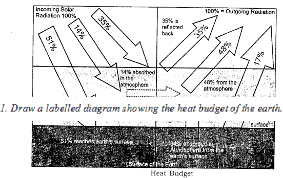
Describe the heat budget of the earth.
Answer:
Heat budget is actually the Heat Balance of incoming and outgoing radiation.
The incoming solar radiation comes towards earth in short waves and provides heat to the earth as insolation in the day and again this insolation is given back by terrestrial radiation at night. This balance is called heat budget.

Question 4.
State how the Global Heat Balance is achieved ?
Answer:
Out of 100 units of solar radiation 35 units are reflected back by atmospheric layers and clouds and snowfields etc, 14 units are absorbed by the ultra-violet rays in ozone layer and only 51 units are received by the earth as insolation and again these 51 units are reflected back by terrestrial radiation out of which 34 units are absorbed by the earth and sent back to atmospheric layers and 17 units radiated back into the space. This process is called the Heat budget or Global Heat Balance.
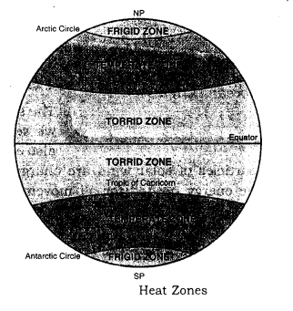
Question 5.
With the help of a diagram, show the heat zones of the earth and write briefly about each of them.
Answer:

  1. Torrid Zone : It lies between 23 1/2° N and 23 1/2° S latitudes. This zone receives maximum temperature due to vertical rays of the sun and maximum rainfall.
  2. Temperate Zone : It lies between 23 1/2° N – 66 1/2° N and 23 1/2° S – 66 1/2° S. It is known for medium temperature and rainfall due to slanting rays of the sun.
  3. Frigid Zone : It lies between 66 1/2° N – 90° N and to 66 1/2° S – 90° S. The sun’s rays are slanting and have to cover a very large distance. Besides this, inspite of long summer covering 6 months, the sun’s heat is immediately reflected back by the snow cover. So, the temperature is extremely low and cold Blizzards (icy winds) blow from Poles towards Arctic and Antarctic circles. The coldest place on the face of the earth is Varkhoyansk (-58°C) in N.E. Siberia. Although the temperature in Antarctic may be -94°C, but there is no habituated place, (as the definition of a place is the area inhabited by people).
    ICSE Solutions for Class 9 Geography Chapter 13 Insolation 1

Question 6.
Study the table and answer the following questions :

  1. Calculate the mean annual temperature
  2. Calculate annual range of temperature
  3. Name the hemisphere in which it is located. Give reasons to support your answer.
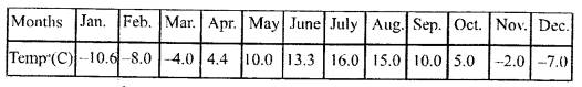
    ICSE Solutions for Class 9 Geography Chapter 13 Insolation 2

Answer:

  1. Sum of the temperature of hottest month of the year 4.4 + 10.0 + 13.3 + 16.0 + 15.0 + 10.0 + 5.0 = 73.7 Sum of the temperature of coldest month of the year
    ICSE Solutions for Class 9 Geography Chapter 13 Insolation 3
  2. Annual range of temperature = Highest temperature in a month of year – Lowest temperature in a month of year = 16°C – 2°C = 14°C
  3. It is located in Northern hemisphere :
    The Reason is due to the Earth’s Axial tilt, in the Northern hemisphere winter lasts from the winter solstice (typically December) to the March Equinox (typically March). While the summer lasts from the summer solstice (typically June) through the autumnal Equinox (typically September).

Question 7.
Name four factors that affect the temperature of a place.
Answer:
Four factors are :

  1. Distance from equator
  2. Distance from sea
  3. Altitude from the sea-level
  4. Slope of the land.

Question 8.
Describe world temperature patterns and its three chief characteristics.
Answer:
The world distribution of temperature generally shows a decreases in insolation from the Equator towards the poles. But this pattern is not everywhere the same. Three chief characteristics are the distance from the sea, physical properties of land and ocean (water), Height from the sea level.

Question 9.
Explain the ranges of temperature and show their calculation.
Answer:
The Diurnal range is calculated by subtracting minimum temperature from the maximum temperature within 24 hours or of one day. The Mean monthly range is calculated by subtracting the mean minimum temperature from mean maximum temperature within 30 days or a month. Annual range of temperature is calculated by subtracting the mean minimum temperature from the mean maximum temperature within one year i.e. mostly between June and January.

V. Practical Exercises

Question 1.
Draw a labelled diagram showing the heat budget of the earth.
Answer:
ICSE Solutions for Class 9 Geography Chapter 13 Insolation 4

Question 2.
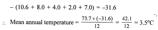
Calculate the mean annual temperature and annual range of temperature of the following station and name the hemisphere in which it is located.
Answer:
Mean annual temperature is 3.5°C.
The range of temperature is 20°C.
It is located in Northern hemisphere.

Practice Questions (Solved)

Question 1.
State the importance of insolation.
Answer:
Importance of insolation The radiant energy received by the earth from the sun is called the incoming solar radiation or insolation. The insolation received by the earth is responsible for all forms of activity on the Earth. The circulation in the atmosphere is due to the differential heating of the atmosphere by insolation. The radiant energy from the sun enables plants to manufacture their own food. This forms the basis for food needed by all other organisms on the Earth. The circulation of ocean water is also due to the unequal heating of the ocean water by insolation.

Question 2.
Why does only 51% of the insolation reach the Earth’s surface ?
Answer:
Only 51% of the insolation reaches the earth’s surface because 35% is reflected back into space by the atmospheric layers and 14% is absorbed by the atmosphere.

Question 3.
What do you understand by daily range of temperature and annual range of temperature ?
Answer:
The difference between the maximum and minimum temperature recorded in a particular day at a place is called daily range of temperature. It is low in coastal areas while it is high in deserts and in interiors of continents.
The difference between the mean temperature of the hottest month (July) and mean temperature of the coldest month is called the annual range of temperature. It is low equatorial region, while it is high in polar areas.

Question 4.
Define the following :

(a) Daily Mean Temperature.
(b) Monthly Mean Temperature.
(c) Annual Mean Temperature.
(d) Mean Temperature of a place.

Answer:

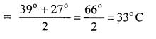
(a) Daily Mean Temperature — The average of the maximum temperature and minimum temperature recorded during a day (24 hours) is known as daily mean temperature.
Daily Mean Temperature
ICSE Solutions for Class 9 Geography Chapter 13 Insolation 5
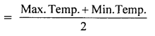
For example, if a place has the maximum temperature of 39°C and minimum temperature of 27°C for a particular day, the daily mean temperature.
ICSE Solutions for Class 9 Geography Chapter 13 Insolation 6
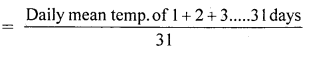
(b) Monthly Mean Temperature — The average of the daily mean temperature of all days of a month is known as monthly mean temperature.
Monthly mean temperature of July
ICSE Solutions for Class 9 Geography Chapter 13 Insolation 7
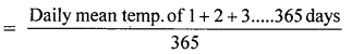
(c) Annual Mean Temperature — The average of daily mean temperature of all days of a year is known as Annual mean temperature.
Annual mean temperature of year 2010
ICSE Solutions for Class 9 Geography Chapter 13 Insolation 8
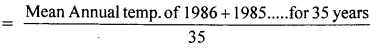
(d) Mean Temperature of a place — Mean temperature of a place is obtained by collecting the data for a period of 30 – 40 years. The average of mean annual temperature of a place is calculated. This is also known as normal temperature of a place.
Mean temperature
ICSE Solutions for Class 9 Geography Chapter 13 Insolation 9

Question 5.
Distinguish between maritime climate and continental climate.
Answer:
The nearness to sea has a moderating influence on the temperature of coastal areas. Maritime or equable temperatures are found in coastal areas. But extremes of temperatures, with a continental climate, are found in inland areas remote from the sea. Due to the presence of land breezes and sea breezes in coastal areas : the summers are warm and winters are cool. This is due to the differential heating and cooling of land and water. Land surfaces are heated more quickly than water. But a greater annual range of temperature is found as we go away from the equator. The climate of Mumbai is more equable than that of Delhi.

Question 6.
Explain the importance of insolation.
Answer:
Sun is the most important source of atmospheric heat. Sun’s diameter is more than 100 times the Earth’s diameter and has a surface temperature of more than 10,000 °F. The heat waves radiate from the sun in all directions at a speed 186,000 miles per second of 3 lakh km per second. The solar radiation received by the earth is 1/2000 millionth part of solar output. Yet, this small amount is vital for our existence on the earth. It is estimated that, on the average the earth receives about 1.9 g calories per minute per sq. cm. This is known as ‘solar constant’. All the physical phenomena depend upon insolation. Winds and ocean currents originate due to insolation. The earth is habitable only due to insolation.

Question 7.
Explain the Greenhouse effect of atmosphere.
Answer:
Atmosphere is heated by the radiation from the earth’s surface below. This action is compared to that of a glasshouse of greenhouse in which vegetable and flowers are grown in polar areas. Glasshouse permits radiation to get in but does not allow radiation to escape out. Therefore, glasshouse is warmer from inside than outside. Atmosphere also acts like a blanket keeping the earth warm. It is known as greenhouse effect of atmosphere. This is due to presence of carbon dioxide in atmosphere. Carbon dioxide has the ability to absorb earth radiation. The carbon dioxide layer acts as a glass roof of the greenhouse. With the increase in carbon dioxide, the temperature of the earth is increasing. Due to this, the year 1955 was the hottest year in India during this century.

Question 8.
What is global warming ? What are its causes ? State its effects.
Answer:
Global warming : The burning of fossil fuels, (coal, gas, petroleum), the cultivation of soil, large scale industrialisation, rapid means of transport and deforestation has caused an imbalance in the atmosphere. These activities are increasing the amount of carbon dioxide. Thus, greenhouse effect has raised the average, temperature of the earth by 0.5°C. By the year 2000, the earth’s, average temperature will go up by 2°C. This is called global warming. Global warming is causing a rise in sea-levels due to melting of glaciers. It is threatening to submerge many coastal areas.

Question 9.
Mountains are cooler than plains. Discuss.
Answer:
The temperature decreases with height at the rate of 1°C per 165 metres or about 0°C per kilometre. The atmosphere is heated by radiation from the earth below. Therefore, lower layers are warmer than higher layers. There is absence of water vapour and dust particles on high mountains. So there is unchecked radiation. That is why mountains are cooler than plains. Shimla is cooler than Delhi. Similarly, Nainital is cooler than Allahabad.

Question 10.
“Winter nights at Delhi are cooler than in Mumbai”. Why?
Answer:
Mumbai has an equable climate due to coastal location, while Delhi is an inland town. The presence of land and sea breezes keep the nights warm at Mumbai.

Question 11.
Vertical rays are Hotter than slanting rays. Why ?
Answer:
Vertical rays are hotter than slanting rays due to the following reasons:

  • Vertical rays heat up a smaller surface. Hence, the heat received per unit of area is large. On the other hand, slanting rays heat up a large area.
  • Vertical rays travel through a shorter distance in the atmosphere and the loss of heat is less. Slanting rays travel a longer distance through the atmosphere where much of its heat is absorbed by clouds, water vapour and dust particles.

Question 12.
Why is noon hotter than morning and evening ?
Or
Maximum temperatures are found in the afternoon. Why?
Answer:
The sun is overhead at noon. The Sun rays are almost vertical. But in the morning and evening, the angle of Sun rays is oblique. Slanting rays fall in the morning and evening. Vertical rays are hotter than slanting rays. As the vertical rays give more heat per unit area, the noon is hotter than morning and evening.

Question 13.
‘Despite its location in higher latitudes, the coast of Norway is never frozen.’ Why ?
Answer:
The areas situated in higher latitudes have a cold climate. In winter, these areas have temperatures below freezing point (0°C). But coast of Norway is never frozen. Its ports are ice free. North Atlantic Drift (Gulf Stream currents) flows along its coast. It is a warm current which raises the winter temperatures of this area.

Question 14.
Why are the northern slopes of Himalayas cooler than its southern slopes ?
Answer:
The Northern Slopes of Himalayas are away from the Sun. These slopes get oblique rays. These slopes are exposed to cold winds. These are shady slopes and are cooler. But the Southern Slopes are Sun facing slopes. These get Sun’s rays more directly and also for longer periods. These are Sunny slopes and shelters from cold winds. So the Southern Slopes of Himalayas are warmer than northern slopes.

ICSE Solutions for Class 9 Geography – Atmospheric Pressure and Winds

ICSE Solutions for Class 9 Geography – Atmospheric Pressure and Winds

ICSE SolutionsSelina ICSE SolutionsML Aggarwal Solutions

Exercises

I. Short Answer Questions.

Question 1.
Define the following terms :

(a) Pressure Gradient
(b) Winds
(c) Coriolis force.
(d) Altitude
(e) Monsoons.

Answer:

(a) Pressure Gradient — It is the rate of change of atmospheric pressure between two points on the earth’s surface.
(b) Winds — Horizontal movements of the air from high pressure to low pressure areas are called winds.
(c) Coriolis force — This force is created by the rotation of the earth as the winds in different belts deflect towards right in Northern hemisphere and to the left in Southern hemisphere.
(d) Altitude — The pressure also decrease with increasing altitude at the rate of 100 millibars in every 1000 metres of height gained.
(e) Monsoons — are the periodic seasonal winds blowing in the regions of South East Asia and Northern Australia. The word monsoon is derived from the Arabic word ‘Mausim’ meaning ‘Season’, on account of deeply affecting the seasons of the particular region.

Question 2.
Name the four main pressure belts of the earth.
Answer:

  • Equatorial low pressure belt
  • Sub-tropical high pressure belt
  • Circum-polar low pressure belt
  • Polar high pressure areas.

Question 3.
What is Circum-polar Low Pressure Belt ?
Answer:
It is the belt of low pressure belt between 60°N – 70°N and 60° S – 70° S.

Question 4.
How does Coriolis Force vary latitudinally ?
Answer:
In the northern hemisphere the winds deflect towards right and in Southern hemisphere deflect towards left due to the effect of the rotation of the earth, e.g. the trade winds take the Southwest direction in place of southern direction in northern tropical belt and in southern tropical belt these winds take northwest direction in place of northern direction.

Question 5.
Name the three chief types of wind.
Answer:
Three chief types of winds are Trade winds, Westerlies, and Polar winds.

Question 6.
What are periodic winds ?
Answer:
Periodic winds blow at regular intervals or in regular cycles. They are winds that result from localised differences in pressure and temperature. For example, land and sea breezes and the seasonal winds.

Question 7.
What are local winds ? Name any two local winds.
Answer:
The local winds blow in certain places and these are warm and cold according to the area from which they blow, e.g. Foehn winds blow descending on the slopes of the Alps and makes the temperature ideal for grapes due to its warm effect. In the same way Chinook winds blowing and coming down from the Rockies mountains in North America helps to increase the temperature and are beneficial to keep grasslands ice free and warms the ranches, so good for animal rearing.

Question 8.
Name two types of variable winds ? Why are they so called ?
Answer:
Variable winds change their direction and force from place to place due to changing the pressure system. These blow for a short time or for a few days. These are cyclones and anticyclones. These are the circular winds with low pressure and high pressure in the centre respectively.

Question 9.
Why are cyclones frequent in summer in the tropical region ?
Answer:
In summer in the tropical region due to die shifting of Doldrums, the low pressure region is strongly originate between 8° and 20° N and S. They mainly originate in China sea and surrounding area. In Bangla Desh, these are known as ‘KalBaisakhi’ rneaning ‘Time of Death’ and cause heavy calamities and destruction. These are known as ‘hurricanes’ in North America, ‘Typhoons’ in China,‘willywillies’ in Australia.

Question 10.
Mention any two differences between Tropical Cyclones and Temperature Cyclones.
Answer:
Tropical Cyclones :

  1. Tropical cyclones are produced mainly over the sea.
  2. They generally originate in the tropical region between 8° and 20°N and S.

Temperature Cyclones :

  1. Temperate cyclones are produced both on land and on sea.
  2. They originate in the mid latitudinal region between 35° latitude and 65° latitude.

Question 11.
How are cyclones named differently in different parts of the world ?
Answer:
The name of the cyclones is different in different parts of the world on the basis of the local languages e.g. hurricanes in America, typhoons in China and Japan, meaning the destructive horrible cyclonic winds.

Question 12.
What are two chief characteristics of anticyclones ?
Answer:
Two chief characteristics are that these provide clear weather and the winds blowing from the centre towards outside in clockwise direction.

Question 13.
Why are the summer monsoons known as South-West Monsoons in the Indian subcontinent ?
Answer:
Due to the low pressure created in the Northern Indian subcontinent and high pressure centre located in the Indian ocean, the Monsoons start to blow from the ocean to the Indian landmass taking a direction from southwest to northeast in summer seasons.

Question 14.
Name the two types of instruments used for measuring pressure. State one point of difference between them.
Answer:
Two types of barometers are used for measuring pressure, e.g. Fortin’s Barometer and Aneroid Barometer. The main difference is that Fortin’s Barometer is filled with mercury, while Aneroid Barometer is without any liquid. Fortin’s Barometer consists of a long narrow tube filled with mercury, while Aneroid is in the round shape like a watch.

Question 15.
Briefly state the variations in the vertical distribution of pressure.
Answer:
Many factors like slope of land, presence of winds and the temperature affect the pressure of air vertically. The rate of decrease is 100 millibars per 1000 metres of height gained. There is a thin air cover at high altitudes, so the percentage and amount of oxygen is also less.

Question 16.
Why are the months of January and July used to describe the world distribution of pressure ?
Answer:
Due to the lowest and highest temperatures recorded in January and July respectively the pressure areas are also affected, so it is preferred to display the distribution of pressure distinctly in January and July.

II. Give reasons for each of the following

Question 1.
The Westerlies in the Southern Hemisphere blow with greater force than those in the Northern Hemisphere.
Answer:
In the Southern Hemisphere there is open ocean for free movement along the belt of Westerlies. These blow with roaring sound and great speed along 40°S. and are known as ‘Roaring Forties’.

Question 2.
There is a seasonal shifting in pressure belts.
Answer:
Due to the earth’s changing aspect with respect to the sun, the pressure belts shift northwards by 5° in summer and southwards in winter resulting in particular seasonal changes, e,g. The cold waves blow in India in winter due to the sub¬tropical belt shifting along 30°N touching the Himalayas. On the other hand in summer the trade winds become powerful in India and push the monsoon winds from east to west in Northern Plain of India.

Question 3.
As we go higher, the atmospheric pressure decreases.
Answer:
As the air become thinner with increasing height, so, the air pressure also decreased. The rate of decrease is 100 millibars per 1000 metres of height gained. So mountain hikers take oxygen cylinder with them to compensate the air inhaled.

Question 4.
The winds are directed to the right of their flow in the Northern Hemisphere.
Answer:
Due to the rotation of the earth from west to east, the winds are deflected to the right e.g. the trade winds blowing from north, to south take north easterly direction.

PQ. Mediterranean lands receive most of the rainfall in winter season.
Answer:
Mediterranean lands come along the belt of Westerlies along 30°S in place of 40°N in winter. So, the Mediterranean countries along 30°N get ample rainfall. Similarly in the Southern Hemisphere the Westerlies blow along 30°S, in winter, so, the southern Mediterranean countries get winter rainfall.

Question 5.
Temperature and pressure are inversely related to one another.
Answer:
When the temperature increases and the air start to rise upwards. creating a low pressure area, but when the temperature decreases, the air start to sink downwards creating a high pressure area on land surface. So, the temperature and pressure are inversely related to one another.

Question 6.
Humid air is lighter than dry air.
Answer:
In tropical region the air is greatly humid due to excess of evaporation creating a low pressure conditions, while the cold regions with less humidity are high pressure areas. So, the humid air is lighter than dry air.

Question 7.
Doldrums is a low pressure belt.
Answer:
Doldrums is a low pressure belt along the equator from 5°N to 5°S. In this belt due to high amount of evaporation, the atmosphere is very calm and quiet due to no circulation of winds and continuous rising air mass creating a hollow like condition in this belt. Inspite of air pushed towards the equator, it is immediately deflected to right and left, creating a vacuum like condition resulting in a belt of calm named as ‘Doldrums’

III. Distinguish between the following

PQ. Isobars and Isotherms
Answer:
Isobars :

  1. These are the lines joining the places of same air pressure.
  2. The closeness of these lines indicate the intensity of pressure.

Isotherms :

  1. These are the lines joining the place of same air temperature.
  2. The closeness of these lines indicate the intensity of temperature.

Question 1.
Cyclones and Anticyclones.
Answer:
Cyclones :

  1. These are the circular winds with low pressure in the centre.
  2. The winds blow anticlockwise from outside to the centre in Northern Hemisphere.
  3. These bring rainfall, clouds thunder lightening.

Anticyclones :

  1. These are circular winds with high pressure in the centre.
  2. The winds blow clockwise from the centre towards all sides in Northern Hemisphere.
  3. These bring clear weather and cold winds.

PQ. Vertical and Horizontal Temperature variation.
Answer:
Vertical Variation :

  1. The Temperature decreases as the height increases
  2. The rate is 1°C for every 166 metres of height.

Horizontal Variation :

  1. The temperature decreases as the latitude increases.
  2. Highest temperatures are found along Equatorial and tropical regions, while least temperature is recorded in polar areas.

Question 2.
Permanent and Periodic Winds.
Answer:
Permanent winds :

  1. These blow throughout the year.
  2. These are named Trade winds, Westerlies and Polar winds.

Periodic winds :

  1. These blow in particular area and seasons.
  2. These are named monsoon winds, Chinook, Foehn, Mistrel winds etc.

Question 3.
Summer and Winter Monsoons.
Answer:
Summer Monsoon :

  1. These blow in summer season from July to September.
  2. These bring heavy rainfall with thunder lightening

Winter Monsoon :

  1. These blow in winter mainly in December and January.
  2. These bring dry cold weather and cold waves.

IV. Long Answer Questions.

Question 1.
What is meant by the term ‘Atmospheric Pressure’ ? Explain briefly the factors that affect Atmospheric Pressure.
Answer:
Atmospheric Pressure refers to the force per unit area exerted against a surface by the weight of the air above that surface. Pressure is expressed in millibars (mb) and measured with a mercury barometer. The average atmospheric pressure at sea level is 1013.25 mb or 760 mm (the) height of the column of mercury in a barometer at sea level). Atmospheric Pressure decreases with height.
Factors affecting Atmospheric Pressure are as below :

  • Altitude : The atmospheric pressure decreases with height or altitude. The decrease in pressure is about 1 cm of mercury for every 110 m of ascent. The atmospheric pressure is highest at sea level. This is because at higher altitudes the air is thinner or less dense than the air at the sea level. The maximum air density is at the earth’s surface ; air density decreases with height because the pull of the earth’s gravity is less. The fewer number of gas molecules at higher altitudes means fewer molecular collisions and a decrease in air pressure.
  • Temperature : Atmospheric pressure decreases with increase in temperature. This is because when the temperature rises, air expands. The molecules of air move far apart (become less dense) and hence exert less pressure. On the contrary, with decrease in temperature the air gets compressed and the space between molecules decreases (becomes more dense) and exerts more pressure on the region.
  • Water Vapour : Water vapour concentration affects atmospheric pressure because the molecular weight of water (18 g/mol) is less than the average molecular weight of air (about 29 g/mol). When water evaporates and enters the atmosphere as a gas, the water vapour molecules take the place of other gas molecules in the air. So, a volume of wet (or humid) air weighs less than an equal volume of dry air. Therefore, humid air is less dense and exerts less pressure than dry air.
  • Rotation of the Earth : Due to the rotation of the earth, bulk of the air at the Poles is thrown away towards the Equator. Since the Equatorial region receives great amount of heat throughout the year, the air becomes warm and light and therefore, it rises and creates low pressure. At the Poles, the cold heavy air sinks down and creates high pressure. In fact, temperature and rotation of the earth together contribute to the formation of world pressure belts.

Question 2.
Explain the swinging of the pressure belts.
Answer:
In summer the pressure belts are pushed northwards and in winter southwards.
ICSE Solutions for Class 9 Geography Chapter 14 Atmospheric Pressure and Winds 1
This shifting takes place upto 5° distance. In summer, it results in remarkable change in weather and climate, e.g. summer monsoon with thunderstorms, lightening and rainfall etc. while, in winter, the Mediterranean climatic regions get rainfall due to Westerlies coming from sea towards land.

Question 3.
Briefly explain the three chief types of winds.
Answer:
The three chief types of winds are Trade winds, Westerlies and polar winds.
Trade winds : blow along the tropical belt from sub-tropical High to equatorial low pressure belts. The name trade is given due to the past time, when trade ships were sailed according to the direction of these winds.
Westerlies : are the winds blowing from western direction. These are south-westerly in northern and north-westerly in the southern hemispheres.
The Polar : winds are icy cool winds blowing from poles towards Circum polar low pressure belts, which are also known as Blizzards.

Question 4.
Describe some of the important types of local winds.
Answer:
Chinook in North America blowing eastwards from the Rockies slopes make the climate of Central Plains ideal for animal rearing and agriculture.
Foehn : winds descending down from the Alps makes the agriculture successful in PO basin and
Mistral : from the Alps along France towards the Mediterranean sea brings the temperature suddenly down instead of bright sunshine.

Question 5.
Explain the weather conditions associated with tropical and temperate cyclones.
Answer:
Tropical cyclones : These are associated with turbulent weather conditions and cause heavy damage to property and human life, e.g. Tornado in North America, Hurricanes in Carribean region, typhons in China and Japan. These blow from south to north.
Temperate cyclones : These are active along mid-latitude region from west to east direction and cover a long region. These are pushed with Westerlies and also called the western Disturbances. These affect from Mediterranean to Pacific ocean covering South European countries, Middle East, Iran, Iraq etc., Pakistan, India, China from west to east. These are associated with rainfall, snowfall, hailstones etc, followed by a clear weather due to coming back anticyclones.

Question 6.
What are the Jet Streams ? What is the significance of Jet Streams ?
Answer:
Jet streams are the concentrated bands of rapid air movement found in troposphere and stratosphere. The meeting front of warm and cold winds along sub-tropical zone near 30° latitude and polar front along 60° latitude. Jet streams transport moisture and help in formation of cyclonic winds. Jet streams are used to forecast the weather specially for air travel, so that the flying should be done according to the jet-streams. Mostly, these jet-streams blow from west to east with the Westerlies.

Question 7.
Describe the world distribution of pressure.
Answer:
The distribution of atmospheric pressure across the latitudes is termed as global horizontal distribution of pressure and represented as pressure belts, e.g. Equatorial low, Sub-Tropical High, Circum-polar low and Polar High pressure belts. It is correlated with the rising up and descending down of the air along low and high pressure belts respectively. Due to the spherical shape of the earth the higher latitudes receive less insolation than the lower latitudes and this difference in temperature different pressure belts are created. Due to extreme low pressure equatorial ‘Doldrums’ (still air) are created.