ICSE Solutions for Class 8 Geography Voyage – Interpreting Topographical Maps
ICSE SolutionsSelina ICSE SolutionsML Aggarwal Solutions
ICSE Solutions Class 8 GeographyHistory & CivicsBiologyChemistryPhysicsMaths
Exercises
A. Fill in the blanks
- A contour line is an imaginary line that connects all points having the same height above sea level.
- In a grid system of a topo sheet, the lines that run vertically are called eastings.
- Contour lines do not intersect one another.
- The contour lines of a hill are evenly spaced in the form of concentric circles.
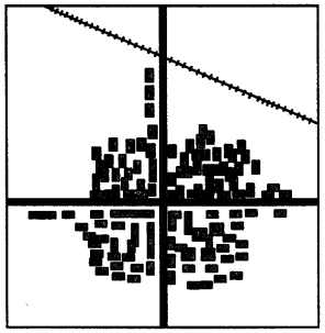
- Houses or huts in scattered settlement are far apart from one another.
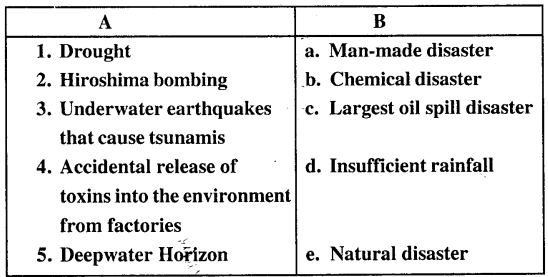
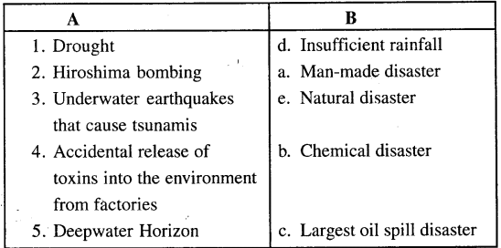
B. Match the following columns
C. Choose the correct answer
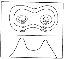
1. The contour lines for this feature are evenly spaced in the form of concentric circles.
- conical hill
- plateau
- ridge
- saddle
2. The contours for this feature are oval with contours close to each other indicating steepness.
- conical hill
- plateau
- ridge
- saddle
3. This feature can be identified by a drop in height of the contours.
- conical hill
- ridge
- col
- gap
4. The green area in a topo sheet contains
- settlement
- barren land
- cultivated land
- vegetation
5. On the topographical map these water bodies are shown in black colour.
- Dry Nadi
- Tank
- Settlement
- River
D. State whether the following are true or false
1. A contour line is an imaginary line that connects all points having the same temperature.
Answer. False.
A contour lines is an imaginary line that connects all points having the same height.
2. The lines that run vertically are called nothings.
Answer. False.
The lines that run vertically are called eatings.
3. Contour lines are drawn at fixed intervals.
Ans. True.
4. A gap is a low lying depression or a valley which cuts through a range of hills.
Answer. True.
5. The spot height is indicated on the map with a small triangle followed by the number.
Answer. False.
The triangulated stations is indicated on the map with a small triangle followed by the number.
E. Answer the following questions in brief
Question 1.
What do topographical maps show ?
Answer:
Topographical maps are large scale maps that show both natural features (such as mountains, hills, rivers, plateaus, ridges, etc) and human-made features (such as roads, railway tracks, temples, bridges, buildings, etc).
Question 2.
What is a contour line ?
Answer:
A contour line is an imaginary line on a map connecting points at the same height above sea level.
Question 3.
Distinguish Vertical Interval and Horizontal Equivalent.
Answer:
The difference in height between two adjacent contour lines is known as the Vertical Interval (V.I.). Whereas the distance between any two adjacent contour lines is called the Horizontal Equivalent (H.E.). The Horizontal Equivalent is calculated with the help of the scale of the map. The value of the H.E. is less when the slope is steep and more when the slope is gentle.
Question 4.
What is a ridge ? How do you identify a ridge on a topo sheet ?
Answer:
A ridge is a long and narrow elevation that has steep slopes on either side and stands out from the surrounding lowlands. It also acts as a watershed to rivers that flow down narrow
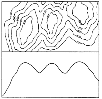
valleys on both of its sides. A ridge could also have several peaks of various elevations.
On a toposheet, the contours of a ridge are oval with contour close to each other indicating steepness.
Question 5.
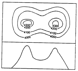
What is a saddle ? Draw a diagram to show a saddle.
Answer:
A saddle is a shallow depression at a high elevation between two peaks or ridges. The depression is formed by streams or by glaciers flowing close to each other. A saddle need not have a river or stream flowing through it.
Question 6.
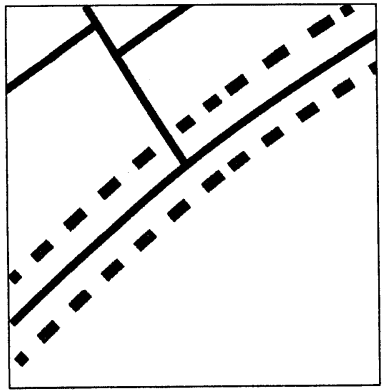
What is a linear settlement ? Where would you normally find a linear settlement ?
Answer:
Linear settlements are those settlements that develop in a line. Houses, shops, dhaba’s, petrol pumps and garages develop along the sides of the roads, railway lines or river banks. Gradually, these linear settlements grow in size. These settlements gradually develop into trading centres. Examples:
- If such a settlement is near a railway track, and over a period of time, a need for a railway station is felt, then it becomes a railway stop.
- hen located on main roads, such settlements become important stops for travellers as dhabas, tyre and car repairing shops and petrol pumps open up.
- On rivers and coasts, they become places where boats can unload goods and passengers.
Question 7.
How would you recognize a metalled road and an un metalled one on a topographical map?
Answer:
Vehicles such as trucks, buses, cars, jeeps, and other modem means of transport move over metalled roads. There are also cart tracks, pack tracks and footpaths, which are unmetalled roads. Cart tracks and pack tracks connect small village settlements in rural areas.
F. Answer the following questions in one or two paragraphs.
Question 1.
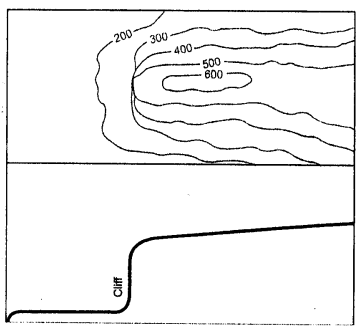
What is a cliff and how can we identify it on a toposheet ? Draw a diagram to show a cliff.
Answer:
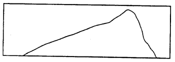
A cliff is a vertical or near vertical land feature. The landform rises vertically from the lower ground. On a contour map, the contour lines are very close together or merge into a single line in other words, contour lines overlap. This indicates a cliff.
Question 2.
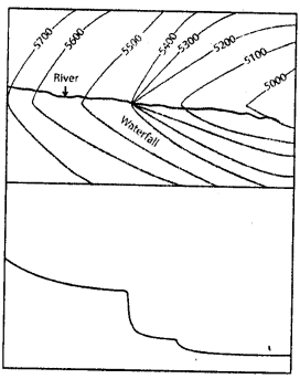
How is waterfall formed? Draw a diagram to show it.
Answer:
A waterfall is formed when there is a sudden drop in the river valley. It is like a cliff where the drop is almost perpendicular. Waterfalls are formed in the upper regions of river valleys. When contours on a map are very close to one another or sometimes touch each other as they cross a river or stream, it indicates the presence of a waterfall.
Question 3.
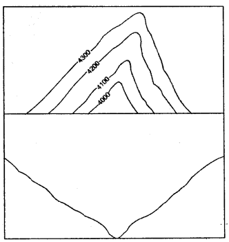
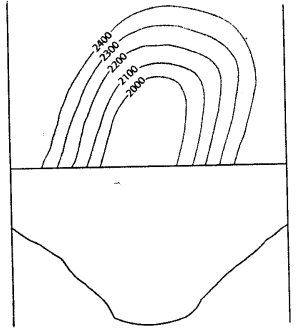
Where are V-shaped valleys and U-shaped valleys formed? How can these be identified on a topo sheet?
Answer:
V-shaped valleys : V-shaped valleys are found in the upper course of a river where the slopes on either side of the river are steep. A V-shaped valley is easily identified on a contour map with the contour lines close to each other and a very dominant V.
U-shaped valleys : U-shaped valleys are found in regions where the action of ice (or glaciers) has widened the valleys so that the valleys take the shape of a “U” These are also found in the lower regions of a river where the erosion of valley walls by the river widens the valley to make them look U-shaped. The contour lines of these valleys are bent in a distinct U-shape.
Question 4.
What are the different factors that determine the location and the type of settlements?
Answer:
Many factors determine the location and the type of settlements:
- Settlements grow in areas that are flat and where the land is cultivable. Settlements do not grow on steep hillsides or marshy lands.
- Settlements grow in places where water is available in plenty for both agricultural and domestic purposes. Settlements, therefore, also grow on the confluence of rivers or the banks of rivers.
- Settlements also thrive on a plateau because of the flat surface of the plateau and the availability of land for cultivation.
- They develop and grow in places where the climate is suitable or pleasant to live in. Extremely hot, cold, wet or dry places are not attractive settlement sites.
- Settlements are formed where there are prospects for employment. Mines and industries in the area are potential sources of employment and encourage growth of settlements. Such places are usually near places of abundant raw materials for the growth of industries.
- They develop in places that are easily accessible by various kinds of roads, rivers, and railway lines. Easy access to and from the settlements will allow movement of people and goods from one place to another.
Question 5.
How can transport and communication of an area be inferred directly from a topographical sheet?
Answer:
On a topographical map you will notice some black lines that cross the map. These lines are symbols of roadways and railway tracks and indicate the type of communication in the area. They depict the various modes of transport being used in the area.
Communication and transport lines indicate the importance of a place. When many roads and railway lines converge in a village or a town, it indicates the importance of a place. It could be for several reasons such as the economic activity of the region or the region could be a tourist hot spot of it could be because of the presence of industries and factories leading to plenty of job opportunities.
Airports are also an important form of travel and communication but airports are confined to large cities only. The conventional sign of an aeroplane indicates the presence of an airport or an airstrip.
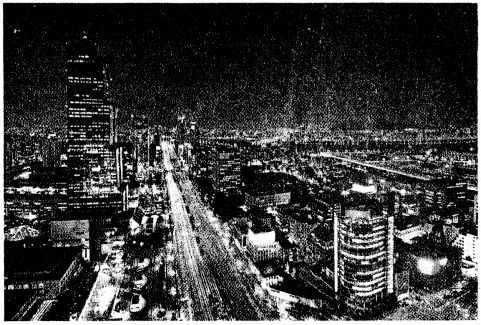
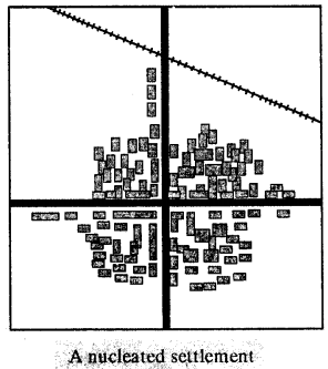
G Picture study.
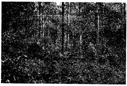
Question 1.
Identify the type of settlement shown in the picture.
Answer:
Nucleated settlements
Question 2.
Write two characteristics of this type of settlement.
Answer:
(i) Linear settlements — Linear settlements are those
settlements that develop in a line. Houses, shops, dhaba’s, petrol pumps and garages develop along the sides of the roads, railway lines or river banks. Gradually, these linear settlements grow in size. These settlements gradually develop into trading centers.
Examples:
(a) If such a settlement is near a railway track, and over a period of time, a need for a railway station is felt, then it becomes a railway stop.
(b) When located on main roads, such settlements become important stops for travellers as dhaba’s, tyre and car repairing shops and petrol pumps open up.
(c) On rivers and coasts, they become places where boats can unload goods and passengers.
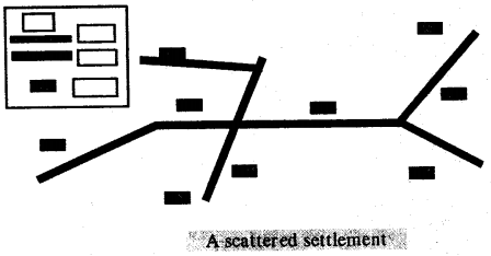
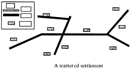
(ii) Scattered settlements — They are also known as dispersed settlements. Houses or huts in this type of settlement are far apart from one another. On map, such settlement is indicated by long distances between houses. Such areas show sparse population and the absence of proper roads. Houses or huts are usually connected by cart tracks or paths. Cattle rearing is common as each household has cattle that is allowed to graze in the open fields. The land is not very fertile to support big populations.
Let’s Do Something
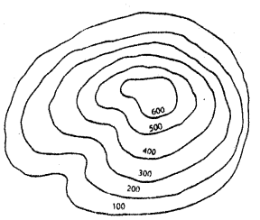
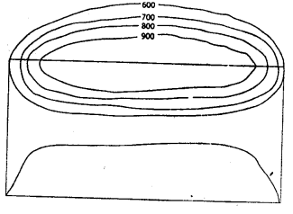
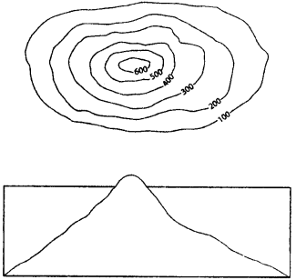
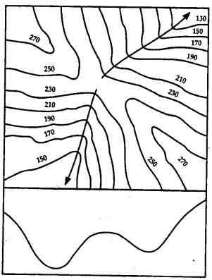
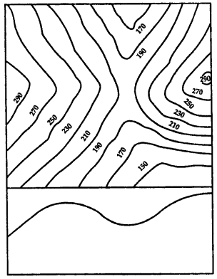
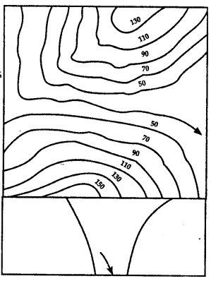
Identify the relief features shown by the following contour diagrams:
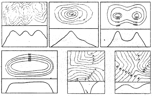
Answer:
(a) A Ridge
(b) A conical hill
(c) A Saddle
(d) A Plateau
(e) A Gap
(f) A Pass
Extra Questions
Question 1.
What do you mean by eastings and northings in a topographical map ?
Answer:
In a grid system of a topo sheet, the lines that run vertically across a topographical map are called eastings. They are measured eastwards from the origin of the grid.
In a grid system of a topo sheet, the lines that run horizontally across a topographical map are called northings. They are measured eastwards from the origin of the grid in northerly direction.
Question 2.
Mention features of a grid system of a topo sheet.
Answer:
Features of the grid system :
- The lines that run vertically are called eastings and those that run horizontally are called northings.
- Eastings and northings cross each other to form a square called as a grid square.
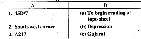
- The starting point or the reference point is the exteme south-west grid or the one at the bottom left corner.
- The numerical value of eastings increases eastwards beginning from the south-west corner. Similarly, the numerical value of northings increases northwards.
- Eastings and northings are always given in two digit numbers. Even 0 is read as 00. (For example, 01, 02, 03, 98, 99.)
- When referring to a grid, eastings are always stated first.
- Eastings and northings on a topo sheet drawn on a scale of 1 : 50,000 are always 2 cm apart, which means they represent a distance of 1 km on the ground. So, the area of 2cm × 2cm on the map represents 1 km × 1 km on the ground.
- There are two types of grid references :
(a) The four – figure reference
(b) the six-figure reference.
Question 3.
Explain the two types of grid references.
Answer:
There are two types of grid references —
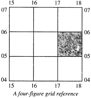
- The four-figure reference : The four-figure reference is used to locate places that fall within the numbered grid square, for example, the grid reference for the shaded square in the diagram below is 1705.
- The six-figure grid reference :
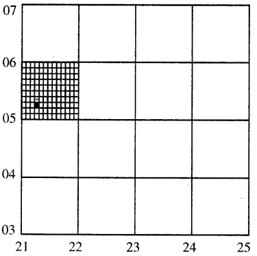
A church shown with the help of a six-figure grid reference The six-figure grid reference is used to locate an object such as wells, post offices, milestones or temples within the square with greater accuracy. In the six-figure grid reference, the first three figures are the eastings while the last three are the northings. To get the six-figure grid reference, we need to divide the grid square on the topo sheet into ten equal parts vertically and horizontally. These figures will give us the third figure for the eastings and the sixth figure for the northings, for example, the grid reference for the church in the diagram is 213052.
Question 4.
Which is the most common method of showing relief or elevation on topo sheets ?
Answer:
Contour lines.
Question 5.
List some basic characteristics of contour lines.
Answer:
Some basic characteristics of contour lines are :
- Contour lines are drawn at fixed intervals, for example 20 m. This is called Vertical Interval (V.I).
- Contour lines do not intersect each other. They could meet and touch but not cross one another.
- On a topographical map, every fifth line is accentuated or drawn thick. This is known as contour index.
- The spacing between the contour lines determines the nature of the slope. Close contour lines indicate steep slope and far apart indicate gentle slope of land. Contour lines drawn at equal intervals indicate that the slope is neither steep nor gentle but is a uniform slope.
Question 6.
How are topo sheets prepared for India ?
Answer:
Topo sheets are prepared three mainly in groups in India :
- The million sheet, where the scale of the sheet is 1:1,000,000 or 1 cm : 10 km ; there are total of 36 of these sheets covering the entire country.
- The quarter inch sheet has a scale of 1: 250,000 or 1 cm : 2.5 km, each of these sheets is numbered separately from A to P.
- The one inch sheet has a scale of 1 : 50,000 or 2 cm : 1 km.
Question 7.
How would you identify the following on a topo sheet:
- Gentle slope and steep slope
- Plateau
- Hill
- Col
- Pass
- Gap
Answer:
- Gentle slope and steep slope — In a steep slope, the contours are drawn close to one another while in a gentle slope they are wide apart.
- Plateau — A plateau or a table land is an uplifted piece
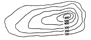
of flat land with slopes on all sides. On a contour map, plateaus are marked by contour lines very close to each other on all sides while there are none or very few lines at the centre. - Hill — A hill is of a lower elevation than a mountain. It has uniform steepness on all sides. The contour lines of a hill are evenly spaced in the form of concentric circles.
- Col — A col is formed when land has been cut considerably between two streams in a watershed. A col can be identified by a drop in height of the contours.
- Pass — Passes are low valleys or opening lying between two peaks in a range of hills. A pass is indicated by a drop in height of contours.
- Gap — A gap is a low lying depression or a valley which cuts through a range of hills It is often occupied by a river.
Question 8.
What do you mean by settlements ? Explain temporary and permanent settlements.
Answer:
Settlements are groups of houses, usually in villages or towns, where people live. The size of settlements depends on the availability of roads, railways, hospitals, police station, administrative buildings, etc. Settlements grow over a period of time. A settlement can be permanent or temporary.
Temporary settlements : Settlements that are constructed and occupied for a short time are called temporary settlements. They are built by people engaged in hunting and gathering, shifting cultivation and transhumance. Tents and huts are the most common forms of shelter in temporary settlements. In urban area, it is built next to a construction site such as a bridge or a flyover. A temporary settlement can become permanent with time.
Permanent Settlements : In this, people build permanent houses. With time, several such structure develop and form a settlement. The availability of water and land for cultivation are important reasons for such settlements growing. Other factors are communication lines such as roads and railways, police stations, post office, hospital, market, health center, etc.
Question 9.
What are the three main types of settlement patterns on a topo sheet ?
Or
Explain types of settlements.
Answer:
The three main types of settlement patterns on a topo sheet are:
(i) Nucleated settlements — In such settlements, buildings and huts are in a compact cluster. They are usually found in plains or valleys. This kind of settlement indicates that the community is living on an area where the land is fertile and good for agriculture. Such settlements generally have a well- knit and large community. Apart from houses, essential facilities like hospitals, police stations, post offices, schools and administrative buildings are found. They are also known as clustered settlements.
(ii) Linear settlements—Linear settlements are those settlements that develop in a line. Houses, shops, dhaba’s, petrol pumps and garages develop along the sides of the roads, railway lines or river banks. Gradually, these linear settlements grow in size. These settlements gradually develop into trading centres.
Examples :
(a) If such a settlement is near a railway track, and over a period of time, a need for a railway station is felt, then it becomes a railway stop.
(b) When located on main roads, such settlements become important stops for travellers as dhaba’s, tyre and car repairing shops and petrol pumps open up.
(c) On rivers and coasts, they become places where boats can unload goods and passengers.
(iii) Scattered settlements — They are also known as dispersed settlements. Houses or huts in this type of settlement are far apart from one another. On map, such settlement is indicated by long distances between houses. Such areas show sparse population and the absence of proper roads. Houses or huts are usually connected by cart tracks or paths. Cattle rearing is common as each household has cattle that is allowed to graze in the open fields. The land is not very fertile to support big populations.
Question 10.
Compare Nucleated settlement and scattered settlement.
Answer:
Nucleated settlement :
- The buildings and huts are in compact cluster.
- These are mostly found in plains or river valleys.
- These are also called as clustered settlements.
- The land is fertile and good for agriculture.
- The generally have a well- knit and large community.
- They have dense population.
- Essential facilities like hospitals, schools, police stations, post offices, etc are found
- Proper communication lines such as roads and railways lines are present.
Scattered settlement :
- The houses and huts are far apart from one another.
- These are mostly found in hilly areas, thick forests and regions of extreme climate.
- These are also called as dispersed settlements.
- The land is not very fertile.
- They don’t have a very close-knit large community.
- They have sparse population.
- Essential facilities like school hospital, police station, etc. are not found.
- Proper roads are absent houses are connected by cart tracks or paths.
Question 11.
List the aspects that you should keep in mind while studying a topographical map.
Or
Name some elements of a topo sheet or topographical maps.
Answer:
Some of the elements of a topo sheet are :
- Sheet number — This number refers to a specific geographical area. It is written on the top of the sheet.
- Scale — The scale is not the same for all maps. It can be 1 : 10,00,000 1 cm : 10 km], 1 : 250,000 [i.e. ; 1 cm = 2.5 km] or 1 : 50,000 [i.e. 2 cm = 1 km] It is written at the bottom of the sheet.
- Grid — The sheets have grid lines in red called eastings and northings which help in locating places easily.
- Direction on map sheet — The top half of a topographical map is always the north and the bottom half is the south. The right hand is the east and left hand is the west. The eastings and northings are read from the southwest corner.
- The eastings and northings — Their numbers should be remembered before reading a map.
- Four-figure grid reference and six-figure grid reference squares — The four-figure grid reference will have four digits and six-figure grid reference will have six digits.
- Legend and keys — Legends contain conventional signs and symbols in the form of keys. They provide the vital information to interpret the map correctly.
- Contour interval — (Vertical interval) It is the vertical distance between two consecutive contour lines. It remains same for a given scale of topo sheets.
- Spot heights — These indicate the actual elevation of a spot above mean sea level.
- Triangulated stations — These also indicate the height on maps. They are indicated on the map with a small triangle followed by the number.
- Contour index — Every fifth contour line is bolder than the other lines for easy identification of contour lines.
- Places marked with letters DEP (depression) indicate land at a lower level than the surrounding area.
- Dry and wet streams — On the map, black streams are dry and blue streams have water.
- Contour features — Like saddle, hill, pass, gentle and steep slope, ridge, etc can be seen on topo maps.
- Colours — Green coloured area contains vegetation and forests, yellow coloured area is cultivated land and white portion is barren land.
Question 12.
What do you mean by Vertical Interval (V.I.) in a topo sheet ?
Answer:
The vertical distance between two consecutive contour lines on a topographical map is called as Vertical Interval (VI). They are drawn at fixed intervals and do not change on the map. This interval depends on the scale of the map and the range of elevation in the area of the map.
Example : VI in all topo sheets of 1 : 50,000 is 20 m.
Question 13.
Mention what do the following indicate on a topographical map —
- Black stream
- Blue stream
- Green area
- Yellow area
- White area
Answer:
- Black stream — It indicates that the stream is dry and has no water.
- Blue stream — It indicates that the stream has water.
- Green area — I indicates vegetation, mainly forests.
- Yellow area — It indicates the area of cultivated land.
- White area — It indicates barren land. No crops are grown in this land.
14. Fill in the blanks
- Eastings and northings cross each other to form a square known as a grid square.
- When referring to a grid, eastings are always stated first.
- Using contours is the most common method of showing relief or elevation on topo sheets.
- On a topographical map, every 5th line is drawn thick and known as the contour index.
- If contour lines are drawn close together, it indicates steep slope of the land and if they are drawn far apart, it indicates gentle slope.
- Settlements are groups of houses where people live, such as villages or towns.
- Tents and huts are the most common forms of shelter in temporary settlements.
- Nucleated or clustered settlement indicates that the large community is close knit and living on a fertile land.
- Linear settlement develop in a line on either side of a road or a railway track.
- scattered or dispersed settlement is indicated by long distances between houses on map.
- Triangulated stations are indicated on the topo sheet with a small triangle followed by the number.
- Settlements are always shown by red squares.
- The grid on the south-west corner of a topographical map is always the reference point or the starting point.