ICSE Solutions for Class 7 Geography Voyage – Greenhouse Effect and Global Warming

ICSE Solutions for Class 7 Geography Voyage – Greenhouse Effect and Global Warming

ICSE SolutionsSelina ICSE SolutionsML Aggarwal Solutions

APlusTopper.com provides step by step solutions for ICSE Solutions for Class 7 Geography Voyage. You can download the Voyage Geography ICSE Solutions for Class 7 with Free PDF download option. Geography Voyage for Class 7 ICSE Solutions all questions are solved and explained by expert teachers as per ICSE board guidelines.

ICSE Solutions Class 7 Geography History & CivicsMathsPhysicsChemistryBiology

DISCUSS

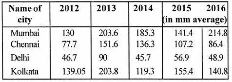
Collect rainfall data from the website of Indian Meteorological Department (IMD) for Mumbai, Chennai, Delhi and Kolkata and discuss how rainfall patterns have changed in the last 5 years.
Answer:
ICSE Solutions for Class 7 Geography Voyage Chapter 4 Greenhouse Effect and Global Warming 1
Mumbai receives maximum rainfall in 2016 and minimum rainfall in 2012.
Chennai receives maximum rainfall in 2013 and minimum rainfall in 2012.
Delhi receives maximum rainfall in 2013 and minimum rainfall in 2014.
Kolkata receives maximum rainfall in 2013 and minimum rainfall in 2014.

VALUES AND LIFE SKILLS :

We need to understand that global warming, climate change, acid rain and ozone depletion are all happening because of our dependence on fossil fuels and CFC-based technologies. Therefore, the need of the hour is to reduce
our dependence on them.
What can you do in this regard ?
Answer:
The ways to reduce our dependency on them are :

  1. By using materials such as bamboo, recycled metal and organic paints in construction of buildings.
  2. By using solar energy to heat and light homes and offices.
  3. By using clean fuel like CNG and unleaded petrol to run vehicles.
  4. By making changes in everyday practices such as
    (a) choosing to travel in public vehicles, biking, walking or using a car pool.
    (b) buying energy efficient household appliances.
    (c) replacing light bulbs with CFL bulbs.

EXERCISES

A. Fill in the blanks.

1. Carbon dioxide and methane, nitrous oxide, water vapour and CFCs are examples of greenhouse gases.
2. Global Warming is a major cause of climate change.
3. The increase in earth’s temperature is called global warming.
4. The layer of atmosphere where ozone is found is called stratosphere.
5. The ozone layer protects us from the ultraviolet rays of the sun.

B. Write True or False.

1. Aeroplanes flying in the sky cause global warming.
Answer. True.

2. Forest fires do not cause global warming.
Answer. False.
Correct : Forest fires do cause global warming.

3. Ozone is found in the troposphere.
Answer. False.
Correct : Ozone is found in the stratosphere.

4. The ozone layer is harmful for humans and animals.
Answer. False.
Correct : The ozone layer is not harmful for humans and animals.

5. CFCs and BFCs protect the ozone layer.
Answer. False.
Correct : CFCs and BFCs deplete the ozone layer.

C. Choose the correct option.

Question 1.
Oxygen/Carbon dioxide is a greenhouse gas.
Answer:
Carbon dioxide is a greenhouse gas.

Question 2.
Use of fossil fuels/hydroelectricity causes global warming.
Answer:
Use of fossil fuels causes global warming.

Question 3.
Cattle release methane / CFCs.
Answer:
Cattle release methane.

Question 4.
Global warming will reduce/increase climate change.
Answer:
Global warming will increase climate change.

Question 5.
The ozone layer is found between 20 and 40/40 and 60 km above the earth’s surface.
Answer:
The ozone layer is found between 20 and 40 and above the earth’s surface.

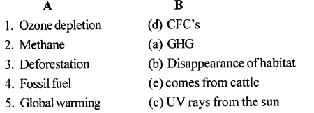
D. Match the following
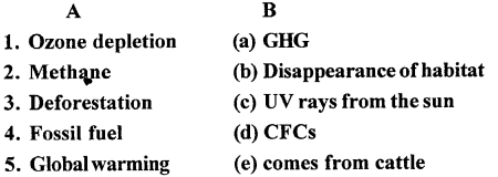
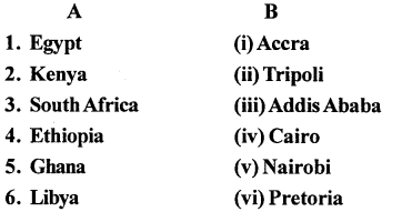
ICSE Solutions for Class 7 Geography Voyage Chapter 4 Greenhouse Effect and Global Warming 2
Answer:
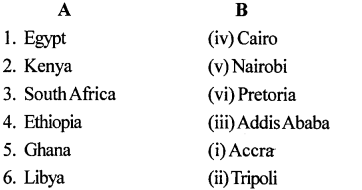
ICSE Solutions for Class 7 Geography Voyage Chapter 4 Greenhouse Effect and Global Warming 3

E. Answer the following questions in brief 

Question 1.
Why do we call carbon dioxide a greenhouse gas?
Answer:
Carbon dioxide is called greenhouse gas because it absorbs
Infrared radiations. A greenhouse gas is a gas in an atmosphere that absorbs and emits radiation within the thermal infrared range.

Question 2.
Name two more greenhouse gases.
Answer:
Methane and water vapour are other greenhouse gases.

Question 3.
How will countries like Bangladesh and Thailand be affected by global warming?
Answer:
Climate change will cause melting of polar ice caps with huge chunks of icebergs several kilometres across breaking off from the mainland. This is already taking place around the Arctic and in Antarctica. The result will be an increase in the volume of ocean waters. Countries like Bangladesh, Thailand and Malaysia and the Southeastern parts of USA like the States of Florida and Louisiana would be swamped by flood water along its shores.

Question 4.
What is responsible for causing a hole in the ozone layer?
Answer:
The release of large amount of CFCs or chlorofluorocarbons and BFCs or bromofluorocarbons by industries are responsible for the formation of holes in the ozone layer.

Question 5.
Name some diseases that are caused due to exposure to ultraviolet rays of the sun.
Answer:
Exposure to UV rays can cause sunburn, cataract, hair loss, skin cancer and birth deformities.

F. Answer the following questions in one or two paragraphs 

Question 1.
How is the greenhouse effect created?
Answer:
The ‘greenhouse effect’ takes place when the ‘sun’s rays heat the earth. This heat is absorbed by the surface of the earth and some of it is radiated back into the atmosphere. However, a part of this heat is trapped in the atmosphere by gases such as water vapour, carbon dioxide and methane while the rest escapes into space. These gases let in light from the sun but prevent the heat from escaping like the glass walls of a greenhouse. They also act like a mirror and reflect back to the earth some of the trapped heat energy. The more greenhouse gases (GHGs) are present in the atmosphere, the more heat is trapped, subsequently making the earth warmer.

Question 2.
State three causes that have led to an increase in greenhouse gases in the atmosphere.
Answer:
The causes that have led to the increase in greenhouse gases (GHGs) are:

  1. Increase in industries
  2. Increase in deforestation
  3. Increase in atmospheric pollution due to emissions from chimneys of factories
  4. Increase in natural disasters like floods, volcanic eruptions and earthquakes that release large amounts of smoke, dust and gases into the atmosphere
  5. Increase in the methane content of the atmosphere because of large-scale cattle rearing, since cattle release methane
  6. Expansion of cies and towns

Question 3.
What do you understand by the term ‘global warming’?
Answer:
The greenhouse gases in the atmosphere trap a part of the heat radiated back by the earth, increasing its temperature. The increase in the earth’s temperature is called global warming.

Question 4.
State some anthropogenic (man-made) causes of global warming.
Answer:
Man-made causes of global warming ‘include burning of fossil fuels, cutting of forests, using refrigerators, air conditioners, aerosols, factories belching smoke, increase in methane content of the atmosphere because of large-scale cattle rearing, expansion of cities and towns.

Question 5.
Global warming does not augur well for our planet earth. State at least three reasons to support this statement.
Answer:
Global warming is not good for our planet as

(a) It will worsen climate changes leading to food shortages.
(b) Many forms of wildlife are now’ at risk and since climate change and deforestation are causing disappearance of their habitat.
(c) Climate change will cause melting of polar caps resulting in the increase in the volume of ocean waters.

G. Picture study.
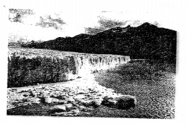
ICSE Solutions for Class 7 Geography Voyage Chapter 4 Greenhouse Effect and Global Warming 4

Question 1.
Which region of the world is seen in the picture?
Answer:
Antarctica and Arctic Poles.

Question 2.
How is it going to be affected by global warming?
Answer:
Global warming causes melting of polar ice-caps with huge chunks of icebergs several kilometres across breaking off from the mainland resulting in increase in volume of ocean waters. The increase in the volume of ocean waters will result in rising of sea levels. Countries like Bangladesh, Thailand and Malaysia and the Southeastern parts of USA like the States of Florida and Louisiana would be swamped by flood water along their shores.

LETS DO SOMETHING

Question 1.
Imagine that you are an active member of the Greenpeace. Write a two-page appeal addressed to the Prime Minister of India stating why you think that increasing number of vehicles on roads will be disastrous to the nation in the long run.
Answer:
August 25, 2017,
Mr. Narendra Modi,
Prime Minister of India
Dear Prime Minister Modi,

It is with great optimism and hope that we are following news about the meeting you will have with U.S. President Trump, at this critical time in our planet’s future. 2017 is the year for making decisive commitments towards tackling climate change together. As the elected leader of the world’s largest democracy, and a country with much to lose from run away climate change, the hopes of 1.3 billion Indian citizens rest on you. Along with them, and the millions of people worldwide who will inevitably be affected by decisions made this year, we hope you will successfully push the United States, and the developed world, towards an ambitious and equitable global agreement to rein in climate change.

We congratulate you on setting new and ambitious renewable energy targets, and urge a focus on decentralized renewable energy as the fastest, most cost-effective way to tackle India’s energy poverty challenge. At the same time, we believe that continued growth in coal power is not in the interests of common Indians as it imposes a significantly higher cost on people’s health, livelihood of communities and the environment, and will prove far more expensive than renewable energy. We hope you will secure much-needed support from global partners, civil society and investors – including the United States administration – to realize these renewable energy goals.

Being the member of the Greenpeace, I would like to bring in your kind notice that I found that the number of vehicles has increased considerably in India in the past five years, which is one of the sources of pollution. In the recently released World Health Organization (WHO) report on pollution, the situation of the city is not so encouraging in terms of pollution in the air.
Due to increase in number of vehicles over the years, the city roads witness frequent traffic congestions, but above all, the vehicles emitting pollutants are affecting environment badly. The recently-released WHO report shows that India has 2.5 microns of diameter (PM2.5) concentration of 68 micrograms particulate matter per meter cube. However, the WHO guideline values for particulate matter is 10 microgram per meter cube for PM2.5.

“The air pollution consists of many pollutants, among other particulate matter. These particles are able to penetrate deeply into the respiratory tract and therefore constitute a risk for health by increasing mortality from respiratory infections and diseases, lung cancer, and selected cardiovascular diseases,” says the WHO report.

New patients with respiratory problems are constantly being reported in hospitals. Recently, the many big cities are witnessing a flow of traffic on city roads consisting high end cars too. Moreover, as far as public transport is concerned, the government-owned low floor buses could be seen plying on the road emitting black smoke causing problems for pedestrians, bikers and other roadside vendors. Mr. Avinash Chowdhry senior member of Greenpeace took out a rally of school children at Statue

Circle (Mumbai) on the eve of World Environment Day said, “Men’s health is determined by his environment. He is greatest enemy of his own health. Environmental pollution is one of the reasons of cardiovascular diseases, hypertension and diabetes.”
Collaboration between the government and civil society is essential to secure a bright future for India and the planet. Greenpeace looks forward to working with the Indian government on our common objective of ensuring clean, affordable renewable energy for all.

Sincerely,
VeenuGopal,
Interim Executive Director, Greenpeace

Question 2.
Make a collage using pictures or a chart to show the various causes and consequences of global warming.
Answer:
You can take idea from the picture given below and can make a collage of your own.
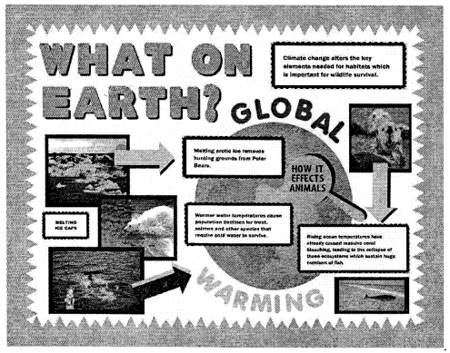
ICSE Solutions for Class 7 Geography Voyage Chapter 4 Greenhouse Effect and Global Warming 5

ICSE Solutions for Class 7 History and Civics – Jahangir, Shah Jahan and Aurangzeb

ICSE Solutions for Class 7 History and Civics – Jahangir, Shah Jahan and Aurangzeb

ICSE SolutionsSelina ICSE SolutionsML Aggarwal Solutions

APlusTopper.com provides step by step solutions for ICSE Solutions for Class 7 History and Civics. You can download the History and Civics ICSE Solutions for Class 7 with Free PDF download option. History and Civics for Class 7 ICSE Solutions all questions are solved and explained by expert teachers as per ICSE board guidelines.

ICSE Solutions Class 7 History & CivicsGeographyMathsPhysicsChemistryBiology

Important Words

  • The chain of justice is said to be a chain installed by Jahangir. It was made of pure gold with 60 bells attached to it, between the palace and the banks of the river Yamuna. Anyone could ring the bell and seek justice.
  • Engineer King is the name by which Shah Jahan is known, as his patronage of architecture is one of the most important characteristics of his reign.
  • Shahjahanabad was a new capital city build by Shah Jahan. Now, it is known as Old Delhi.

Time To Learn

I. Fill in the blanks:

  1. Taj Mahal, a symbol of love, shows a variety of cultural influences.
  2. Jahangir installed a chain of justice for the seekers of justice.
  3. The treaty of Purandhar was signed between Mughals and Rajput ruler Jain Singh.
  4. The original name of Nur Jahan was Mehrunnisa.
  5. Bijapur was annexed in AD 1686.
  6. Aurangzeb reimposed Jazia and pilgrimage tax.
  7. Guru Tegh Bahadur, ninth Sikh guru, was executed on Aurangzeb’s order.
  8. The Sikhs were organised into a military force called the Khalsa.

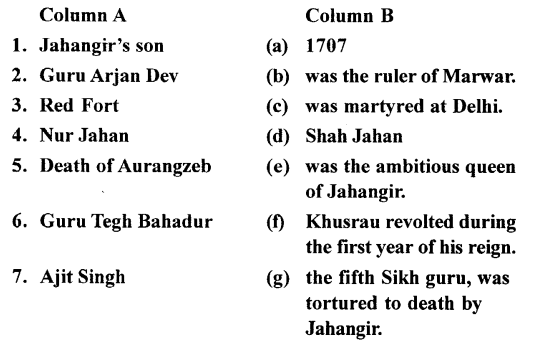
II. Match Column A with Columb B:
ICSE Solutions for Class 7 History and Civics - Jahangir, Shah Jahan and Aurangzeb 1
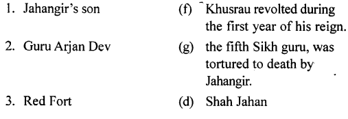
Answer:
ICSE Solutions for Class 7 History and Civics - Jahangir, Shah Jahan and Aurangzeb 2

ICSE Solutions for Class 7 History and Civics - Jahangir, Shah Jahan and Aurangzeb 3

III. State whether the following statements are True or False:

  1. Jahangir left the administration in the hands of his queen,Nur Jahan.
    True.
  2.  Nur Jahan’s influence was good and lasting for theMughal Empire.
    False.
  3. Shah Jahan had to fight for the throne.
    True.
  4. Shah Jahan married Mumtaz Mahal, in whose memory the built the Taj.
    True.
  5. Shah Jahan died in AD 1666, as a captive in the fort of Agra.
     True.
  6. Aurangzeb had friendly relation with the Rajputs and theMarathas.
     False.
  7. The Sikhs were hostile to the Mughal Emperor after the execution of the ninth Sikh guru.
    True.
  8. Aurangzeb died in 1707 in the Red Fort at Delhi.
    False.
  9. Aurangzeb reimposed .
    True.

IV. Answer the following questions briefly:

Question 1.
Jahangir is sometimes called a mixture of opposites. Discuss.
Answer:
Sometimes Jahangir was needlessly cruel and inflicted punishments disproportionate to the offence committed. For this combination of good qualities and bad qualities of his character some historian have rightly called him as ‘the mixture of opposites’.

Question 2.
How did Jahangir deal with the European traders? Name two travellers who visited Jahangir’s court.
Answer:
Jahangir was on good terms with the Portuguese traders. He gave them some trade concessions.Captain Hawkins and Sir Thomas Roe, visited Jahangir’s court.

Question 3.
The age of Shah Jahan is the Golden Age of Mughal rule. Do you agree? Give reasons for your answer.
Answer:
Yes, The age of Shah Jahan is the Golden Age of Mughal rule. The points describing are as follows:

  1. During the regin of Shah Jahan, there was undisturbed peace within the country. There were no foreign threats and Shah Jahan too devoted most of his time in maintaining peace and order in the country. Trade and commerce flourished bringing in lots of wealth. The land was fertile and revenue flowed into the treasury.
  2. Shah Jahan carried out many works of public welfare. Roads, canals, bridges, sarais, etc., were constructed for the welfare of the people. Similarly, during the famine and plague he did a lot to relieve the people of their sufferings.
  3. Shah Jahan had a natural love for magnificence, which was reflected in the buildings that he constructed. His reign is, in fact, called the Golden Age of the Mughal Architecture. One of the most important buildings constructed by him is the Taj Mahal, which was built in the memory of his beloved wife Mumtaz Mahal.

Question 4.
Describe the religious policy of Aurangzeb. What were its results?
Answer:
Aurangzeb’s religious policy had two aspects i.e:

  1. To promote the tenets of Islam and to ensure that the people led their lives accordingly.
  2. To adopt anti-Hindu measures.

The religious fanaticism of Aurangzeb overshadowed his virtues. His reversal of Akbar’s policy of religious toleration resulted in weakening the entire structure of the Mughal empire. It led to several conflicts and wars in different parts of the country.
These conflicts were:

  1. Conflict with the Jats
  2. Conflict with the Satnamos
  3. Conflict with the Sikhs
  4. Conflicts with the Rajput’s
  5. Conflict with the Marathas.

All these rebellions destroyed the peace of the empire, disrupted its economy, weakened the administrative structure, diminished its military strength, led to the failure of Aurangzeb to make any impact. Ultimately all these contributed to the downfall of the Mughal enterprise.

Question 5.
Who were the Sikhs? How did they emerge as a political power?
Answer:
Khalsa’s were the sikhs.
Open wars started between the Sikhs and the Mughals after Ninth Sikh Guru, Guru Tegh Bahadur was executed on Aurangzeb’s order. Aurangzeb and his successors had to face continous trouble from the sikhs. After Aurangzeb’s death, his successors failed to check the rising power of the Sikhs. The Sikhs gradually emerged as a political power.

Question 6.
Briefly describe aurangzeb’s clash with : (a) the Rajputs, (b) the Marathas, (c) the Sikhs.
Answer:
(a)
The Rajputs were not well treated by Aurangzeb. Raja Jai Singh and Raja Jaswant Singh were kept away from the court at Delhi. Raja Jai Singh was a loyal general but he was suspected and insulted after the escape of Shivaji.
(b)
Conflicts started between the Mughals and the Marathas over the conquest over the conquest of Bijapur.
(c)
The relations between the Sikhs and the Muslims were already strained because of Guru Arjan Dev’s execution at the hands of Jahangir for helping his rebel son. From then onwards, the Sikhs had become the enemies of the Mughals. Guru Gobind Singh, the tenth Guru and son of Guru Tegh Bahadur, continued the policy of his father. He organised the Open wars started between the Sikhs and the Mughals.

Question 7.
Why do you think Aurangzeb reimposed some taxes?
Answer:
Aurangzeb reimposed Jazia and pilgrimage tax because of his othodox relious policies.

Question 8.
Explain the factors responsible for the decline of the Mughal empire.
Answer:
The factors responsible for the decline of the Mughal empire are:

  1. Aurangzeb’s Faulty Policies: Aurangzeb followed an orthodox religious policy. He reimposed Jazia and pilgrimage tax. Thus, he antagonised not only the Hindus but also the Muslims. He also made enemies of communities like the Jats, Sikhs and the Marathas.
  2. Aurangzeb’s Deccan Policy: The conquests of Bijapur and Golconda made the empire too big to be administered efficiently. Moreover, Aurangzeb’s long stay in the Deccan (almost 25 years) neglected the administration of his empire in the North. His absence also helped the rise of the Maratha power.
  3. Weak Successors: Aurangzeb’s successors were incompetent and weak, and they could not suppress the revolts or control the nobles. They become too ambitious, and independent. Eventually, the governors of the Deccan, Awadh and Bengal declared themselves as independent rulers.
  4. Empty Treasury: Aurangzeb maintained a large standing army. But his long wars in the Deccan caused a big drain on the state treasury. Thus, after the death of Aurangzeb (AD 1707), the treasury became empty and the later Mughal rulers were unable to pay the soldiers and officers and meet their expenses.

V. Write a short note on 

Question 1.
Aurangzeb’s Deccan Campaigns
Answer:
Aurangzeb wanted to crush the growing powers of the Maratha’s. As these people were very strong and courageous and they also did not accept the over lordship of the ruler. This empire was also very vast and prosperous, so Aurangzeb wanted to have it under his control.

Question 2.
Abdali’s invasion on India
Answer:
Ahmad Shah Abdali invaded India several times between 1747 and 1767. He gave a crushing defeat to the Marathas in 1761 in the third Battle of Panipat. The Marathas could not regain their past power ever again.

Additional Questions
(Jahangir, Shah Jahan and Aurangzeb)

A. Fill in the blanks:

  1. Nur Jahan became the virtual ruler of the Mughal empire.
  2. During the final years of Jahangir’s reign, there was a power struggle between Nur Jahan and Shah Jahan.
  3. Shah Jahan’s reign is often referred to as the Golden Age of the Mughal empire.
  4. Aurangzeb spent the first half of his reign in the North and the second half in the Deccan.
  5. Aurangzeb spent the last twenty six years of his reign fighting against the Marathas and the Sultanates of Bijapur and Golconda.

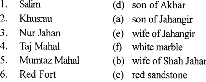
B. Match the following:
ICSE Solutions for Class 7 History and Civics - Jahangir, Shah Jahan and Aurangzeb 4
ICSE Solutions for Class 7 History and Civics - Jahangir, Shah Jahan and Aurangzeb 5
Answer:
ICSE Solutions for Class 7 History and Civics - Jahangir, Shah Jahan and Aurangzeb 6


C. Choose the correct answer:

1. The foundations laid by Akbar/Babur/Humayun were so strong that Jahangir did not have any major problems maintaining the empire.
Ans. The foundations laid by Akbar were so strong that Jahangir did not have any major problems maintaining the empire.

2. Shah Jahan built the magnificent Agra Fort/Taj Mahal/ Red Fort in the memory of his wife Mumtaz Mahal.
Ans. Shah Jahan built the magnificent Taj Mahal in the memory of his wife Mumtaz Mahal.

3. Shah Jahan built a new city called Fatehpur Sikri/ Daulatabad/Shahjahanabad.
Ans. Shah Jahan built a new city called Shahjahanabad.

4. Aurangzeb’s reign can be roughly divided into four/ three/two
Ans. Aurangzeb’s reign can be roughly divided into two periods.

5. One of the most serious challenges faced by Aurangzeb came from the Sikhs/Marathas/Rajputs in the Deccan.
Ans. One of the most serious challenges faced by Aurangzeb came from the Marathas in the Deccan.

D. State whether the following are true or false:

  1. Jahangir defeated the Rana of Mewar.
     True.                                                                              ’
  2. Jahangir is said to have installed a chain of justice.
    True.
  3. The Peacock Throne was taken to Persia by Nadir Shah.
    True.
  4. The Jama Masjid is said to be the most perfect of Jahangir’s buildings.
    False. Correct: The Jama Masjid is said to be the most perfect of Shah Jahan’s buildings.

E. Answer the following questions in one or two words/ sentences:

1. Why did Jahangir not face any major problems in maintaining his large empire?
Ans. The foundations laid by Akbar were so strong that Jahangir did not have any major problems maintaining the empire.

2. Name Jahangir’s son who rebelled against him.
Ans. The rebellion of his eldest son, Khusrau.

3.Why is Shah Jahan known as the Engineer King?
Ans.Shah Jahan is known as Engineer King due to his work in the field of architecture. During his time magnificent buildings were constructed which are remembered still now. Some of the finest examples of monuments during his reign are — the magnificent Taj Mahal at Agra, the Moti Masjid at Agra Fort and the dignified Jama Masjid at Delhi.

4. Which fort did Shah Jahan build in the new city of Shahjahanabad?
Ans.Red Fort.

5. Who succeeded Shah Jahan as the Mughal emperor?
Ans.Shah Jahan’s third son, Aurangzeb.

6. State any one major cause of the decline of the Mughal empire.
Ans.He spent too much money on military expeditions and building magnificent monuments which drained the royal treasury.

7. What was the nature of Aurangzeb’s Rajput policy in the early years of his reign?
Ans.During the early years of his reign, Aurangzeb followed Akbar’s policy of friendship with the Rajputs. He granted the Rajput rulers high mansabs and tried to win their support.

8. What were the objectives of Aurangzeb’s Deccan policy?
Ans.Aurangzeb wanted to crush the growing powers of the Maratha’s. As these people were veiy strong and courageous and they also did not accept the overlordship of the ruler. This empire was also very vast and prosperous, so Aurangzeb wanted to have it under his control.

9. Why did the annexation of Bijapur and Golconda prove harmful for the Mughal empire?
Ans.It became too vast and unwieldy and brought the Mughals into direct contact with the Marathas.

F. Answer the following questions briefly:

Question 1.
Jahangir fulfilled Akbar’s unrealized imperial dreams by conquering Mewar. Explain.
Answer:
Jahangir sent an expedition against Rana Amar Singh of Mewar who, like his father, Rana Pratap Singh, had refused to acknowledge the overlordship of the Mughal emperor. The Rana of Mewar was defeated. He pledged his loyalty to Jahangir, who treated him with courtesy. He allowed the Rana to retain his territory and appointed his son, Kama, as a military commander in the imperial army. The submission of Mewar established the paramountcy of Mughal authority in Rajputana and marked the fall of the last bastion of Rajput resistance.

Question 2.
To what extent were Jahangir’s Deccan campaigns successful?
Answer:
Jahangir sent an expedition under Prince Khurram who managed to recapture the fort of Ahmadnagar. Prince Khurram was honoured with the title of Shah Jahan (Lord of the World). The war continued and by the end of Jahangir’s reign, Ahmadnagar reasserted its independence and remained outside Mughal control.

Question 3.
What qualities did Nur Jahan possess to make her worthy of her name?
Answer:
Nur Jahan means-light of the world and according to her name she possessed all the qualities like she was intelligent, beautiful, educated and cultured. She was a good poet and designer too. She designed new varieties of fabrics and jewellery. She was also strong and courageous and helped Jahangir to take decisions in matters related to the government.

Question 4.
Nur Jahan was very ambitious and eventually became the power behind the throne. Explain.|
Answer:
Nur Jahan was ambitious and soon became the power behind the throne. Jahangir consulted her on all matters concerning the affairs of the government. Nur Jahan soon became the virtual ruler of the Mughal empire. Graudally, Jahangir left the administration in her hands and spent his time indulging in his addiction to wine and opium. Coins began to be issued jointly in the name of Jahangir and Nur Jahan. Nur Jahan used her positioin and influence to appoint her father, brother and other relatives to important posts in the administration. Her niece, Mumtaz Mahal, was married to Jahangir’s third son, Khurram (Shah Jahan).

Question 5.
Shah Jahan’s reign was an age of splendour and cultural brilliance. In this context, discuss:
(a) Taj Mahal
(b) Red Fort
Answer:
(a) Taj Mahal: It took more than 20 years to complete the Taj Mahal, at a cost of one crore rupees at that time. It is made of pure white marble and is lavishly decorated with semi-precious stones and lace-like screens. It is an octagonal monument with a splendid dome and four slender minerals, set in a beautiful garden,
(b) Red Fort: This building is made of red sandstone. There are many splendid buildings inside the Red Fort. The Diwan-i-Khas is the most impressive. Its ceiling is made of silver. Its walls are made of marble and decorated with gold and semi-precious stones.

Question 6.
Why did Aurangzeb’s Deccan campaign against the Marathas prove to be a ruinous misadventure? What were the long-term consequences of this campaign?
Answer:
The Deccan campaign proved to be a ruinous misadventure that showed lack of political wisdom.
Suspicious by nature, he did not trust his sons and nobles. His officials were like puppets on strings. Aurangzeb’s supervision of every department often bordered on interference. His policy of discrimination between his subjects on grounds of faith also made him unpopular. He was a man of unshakeable convictions and tried very hard to reach his goals by doing what he thought was right. As he lay on his deathbed, he wrote several letters to his son. In one letter he wrote, ‘I know not who I am or why I came into the world … I have not done well for the country or its people . . . I know what punishment will be in store for me to suffer.’ During the first half of the 19th century ce, the great Mughal empire decayed and disintegrated. The Mughal emperors lost their power and glory and their vast empire finally shrank to a few square miles around Delhi.

Question 7.
Why did Aurangzeb fail as a ruler?
Answer:
Aurangzeb possessed qualities of an ideal man but he was failure as a ruler. Like his father he was not able to follow the policy of religious tolerance and friendship. His list of enemies not only included Rajput’s but also Sikhs and the Marathas. He was also very suspicious by nature, which was not liked by his officials. His policy of discrimination with his subjects also made him an unpopular ruler.

Question 8.
Briefly explain the negative aspects of Shah Jahan’s reign that eventually led to the decline of the Mughal empire.
Answer:
The policy of religious tolerance and friendship with the Rajputs was continued by Shah Jahan.Behind the glamour and the glitter of Shah Jahan’s reign, however, lurked some disturbing shadows.

  1. Shah Jahan’s military expeditions to Central Asia and Kandahar and the extravagant building projects drained the royal treasury.
  2. To improve the country’s financial resources, heavier taxes were imposed on the peasantry.
  3.  According to Bernier, the French traveller, many villages were mined and left desolate. This setback to agriculture became a major cause of the decline of the Mughal empire.
  4.  The failure of military campaigns during this period was an indication of the decline of the military might of the Mughals.
  5. The administrative machinery had grown in size but corruption had crept in.

G Picture study:

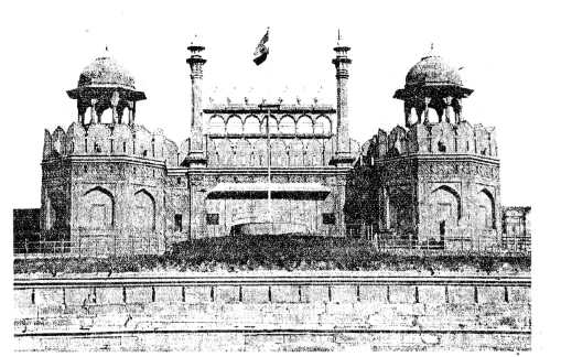
This is a picture of a 17th century-CE monument, built in red sandstone by a Mughal emperor.
ICSE Solutions for Class 7 History and Civics - Jahangir, Shah Jahan and Aurangzeb 7

Question 1.
Identify the monument.
Answer:
Red Fort.

Question 2.
Where is it located?
Answer:
Old Delhi.

Question 3.
Who built this monuments?
Answer:
ShahJahan.

Question 4.
Name two important buildings inside this monument.
Answer:
(a) Diwan-i-Khas
(b) Diwan-i-Aam

Question 5.
Mention its important features.
Answer:
Important features are as:
The Diwan-i-Khas is the most impressive. Its ceiling is made of silver and its walls are made of marble decorated with gold and semi-precious stones.
Diwan-i-Aam was Shah Jahan’s Peacock Throne. It had a canopy supported by twelve emerald pillars, each bearing two peacocks studded with gems. This golden throne, which took 7 years to complete, was taken to Persia by Nadir Shah in 1739 ce.

ICSE Solutions for Class 7 Geography Voyage – Africa: Location, Area, Political & Physical Features

ICSE Solutions for Class 7 Geography Voyage – Africa: Location, Area, Political & Physical Features

ICSE SolutionsSelina ICSE SolutionsML Aggarwal Solutions

APlusTopper.com provides step by step solutions for ICSE Solutions for Class 7 Geography Voyage. You can download the Voyage Geography ICSE Solutions for Class 7 with Free PDF download option. Geography Voyage for Class 7 ICSE Solutions all questions are solved and explained by expert teachers as per ICSE board guidelines.

ICSE Solutions Class 7 Geography History & CivicsMathsPhysicsChemistryBiology

THINK AND ANSWER

Why did Africa remain unexplored for a long time ?
Answer:
The equator passes through the middle of the continent and most of Africa lies within the tropics. It is, therefore, the hottest continent.
People faced many difficulties while exploring Africa. In the north, the Sahara, the world’s largest desert, was impenetrable due to severe heat and dry conditions. Most of Africa consists of undulating plateaus, so it was difficult to reach the interior from the coastal areas. The rivers of Africa have many rapids and waterfalls, and are not fit for navigation. The extensive equatorial forests and swampy lands teeming with dangerous tsetse flies and poisonous insects discouraged explorers from entering the heart of the continent.

Discuss

Deforestation rate in Africa is twice the average for the rest of the world with more than four million hectares of primary forest disappearing every year. What could be the reasons for this.
Answer:
The reasons would be :

  1. Conversion of forests for subsistenance and commercial agriculture.
  2. Deforestation done because of commercial logging
  3. Other activities such as cattle rattling, cash crop plantations, and the construction of dams, roads and mines.

VALUES AND LIFE SKILLS

The Sahara Desert forms a large part of Africa. This desert extends from the Atlantic in the west to the Red Sea in the east.
Suppose you were going to the Sahara Desert. List the things you would take with you.
What kind of problems are you likely to face ?
How would you cope with them ?
Answer:
The things one should carry and the problems we can face are discussed below :
1. Preparing for Desert Emergencies —
(a) Wear clothing that minimizes sweat loss : Most of your body’s water loss happens through perspiration. Cover as much skin as possible with loose, light-weight clothing. This will trap the sweat against your skin, slowing evaporation and therefore water loss.
(b) Bring lots of extra water : Whenever you enter a desert, bring more water than you expect. While walking in sunshine and 40°C (104°F) heat, the average person loses 900 mL (30 oz) of sweat every hour. In an emergency situation, you’ll be thankful for any water you carried.

  1. Divide the water you’ re carrying among several containers. This minimizes the amount of water you can lose to one leak.
  2. Store the excess in a cool spot in your vehicle, away from direct sunlight.

(c) Bring food that packs the most nutrition in the least size and weight: Energy bars, pemmican, jerky, and trail mix are popular choices. Do your research, experiment beforehand, and be prepared. When wheeled vehicles break down, it’s just your two legs and the path to the next town, and you don’t want to be carrying anything nonessential.
(d) Pack survival equipment: Here are the bare essentials for a survival kit:

  1. Sturdy emergency blankets
  2. Cords or rope
  3. Water purification tablets
  4. First aid kit
  5. Fire starters
  6. Powerful flashlight or headlamp. LEDs last longest.
  7. Knife
  8. Compass
  9. Signal mirror
  10. Goggles and a dust mask or bandana (for dust storms)

2. Survival Tactics :
(a) Become nocturnal: In a desert survival situation, you do not want to be moving around during the day. The cooler night air enables you to travel farther and faster with minimum danger of heat exhaustion. In hot climates, this single decision will save your body about three liters (three quarts) of water per day.
(b) Stay in a shelter during the day: If you don’t have a shaded car to stay in, string cords between a pair of objects in a place that gets shade most of the day. Drape a sturdy emergency blanket over the cords. Place a few pieces of brush on top of the blanket, then cover it with another emergency blanket (this one can be a thin Mylar sheet). The gap of air between the two blankets insulates the shelter, keeping it cooler.
(c) Signal for help : Building a fire is a great way to make a signal, creating smoke during the day and light at night. While in transit, keep a signal mirror in reach to reflect light at passing aircraft or distant cars.
(d) Decide whether to stay in place : If you have a supply of water and someone knows where you are, staying in one place may be your best chance of rescue. Traveling to find help will exhaust you much faster than staying in place, and water loss will cut your survival time way down if you can’t find another supply. That said, if your water supplies are low, you will need to look for more. You cannot expect to survive more than a couple of days if you run out of water.
(e) Find water sources : If there’s been a rainstorm recently, you may find pockets of water in rock outcrops or flat stone surfaces. More often, you’ll need to search for areas with possible groundwater:

  1. Follow animal tracks leading downhill, birds circling around something, or even flying insects.
  2. Walk to the greenest vegetation you can see, especially large plants with wide leaves.

3. Recognizing Dangers
(a) Watch out for signs of dehydration : Many people make their journey much harder by underestimating their water needs. Trying to ration your supply is a mistake that can cost your life. If you notice any of the following symptoms, drink more water:

  1. Urine with a dark color or a noticeable smell.
  2. Dry skin
  3. Dizziness
  4. Fainting

(b) Rest if you experience heat exhaustion : If you feel lightheaded or nauseous, or if your skin feels cool and clammy, seek shade immediately. Rest and treat yourself as follows:

  1. Remove or loosen your clothing
  2. Sip a sports drink or slightly salty water (about 5 mL salt per liter water /1 tsp per quart).
  3. Apply wet cloth on your skin to aid cooling evaporation.

(c) Stay away from dangerous animals : Most mammals and reptiles will stay away from you, especially if they are alone. Follow the same practice and be aware of your surroundings to avoid accidentally cornering something.

EXERCISES

A. Choose the correct answer :

1. The strait that separates Europe from Africa is the

  1. Palk Srait
  2. Bering Strait
  3. Strait of Gibraltar
  4. trait of Magellan

2. A large portion of Africa lies in the

  1. desert
  2. tropics
  3. temperate region
  4. marshy land

3. The area in a desert where water can be found is called a/an

  1. pond
  2. well
  3. depression
  4. oasis

4. The Sudd is a

  1. lake
  2. swamp
  3. gulf
  4. cape

5. The largest lake in Africa is

  1. Lake Chad
  2. Lake Tana
  3. Lake Victoria
  4. Lake Tanganyika

B. Identify who I am

1. i am a country through which the Tropic of Capricorn passes: Namibia.
2. I am the southernmost tip of Africa: Cape of Good Hope.
3. I am a snow-capped mountain near the equator: Mt. Kilimanjaro.
4. I am the longest river of Africa: Nile.
5. I am a river that flows into Lake Chad: The Chari.
6. I am a lake that does not lie in the Great Rift Valley of Africa: Lake Victoria.
7. I am a river that flows through the Namib Desert: Okavango

C. Match the following:

ICSE Solutions for Class 7 Geography Voyage Chapter 14 Africa Location, Area, Political & Physical Features 1
Answer:

ICSE Solutions for Class 7 Geography Voyage Chapter 14 Africa Location, Area, Political & Physical Features 2

D. Give geographical reasons

Question 1.
People faced many difficulties while exploring Africa.
Answer:
It was difficult to explore Africa because of deserts like Sahara which have severe heat and dry conditions, the undulating plateaux, non-navigable rivers, extensive equatorial forests, swampy lands and poisonous insects.

Question 2.
The rivers of Africa are not very suitable for navigation in their lower course.
Answer:
The rivers have many rapids and waterfalls making them unfit for navigation.

Question 3.
The river Nile flows through a desert and yet has water throughout the year.
Answer:
River Nile has water throughout the year because its source is Lake Victoria which lies in the rainy equatorial region.

E. Answer the following questions briefly.

Question 1.
Give the latitudinal extent of Africa and explain why it is mostly a tropical continent.
Answer:
Latitudinal extent of Africa is 37°N to 35°S. Africa is known as mostly tropical continent because a large portion of Africa lies in the Tropics, the Tropic of cancer (23 1/2° N) in the North and the Tropic of Capricorn (23 1/2° S) in the South.

Question 2.
Name three great explorers connected with the African continent.
Answer:
David Livingstone, who discovered Victoria Falls in 1855. Mungo Park followed the course of the river Niger. Henry Morton Stanley traced the course of the river Congo from Lake Tanganyika to its mouth.

Question 3.
Name the major mountain ranges of Africa.
Answer:
The Atlas Mountains lie in north-western Africa. They are young fold mountains consisting of three parallel ranges—the Tell Atlas in the north, the High Atlas in the middle, and the Sahara Atlas in the south. The highest peak in the Atlas Mountains is Mt Toublkal, which remains snow-capped most of the year.

Question 4.
Name the lakes found in the Great Rift Valley.
Answer:
The lakes found in the Great Rift Valley are Lake Malawi, Lake Mobutu, Lake Edward and Lake Turkana.

Question 5.
How much time does it take the cocoa tree to yield cocoa pods ?
Answer:
An evergreen tropical plant, the cocoa tree grows to a height of 4 to 9 m. It begins to yield cocoa pods after about 5-7 years. Cocoa pods grow on the trunk and main branches. Each pod is about 18-25 cm long and contains pulp with beans.

F. Answer the following questions in one or two paragraphs

Question 1.
Elaborate on the achievements of the great explorers in opening up the continent of Africa.
Answer:
Explorers like David Livingstone discovered Victoria Falls. Mungo Park discovered the course of river Niger. Henry Morton Stanley traced the source of river Congo from Lake Tanganyika to its mouth.

Question 2.
Name the major physical divisions of Africa. Describe any one.
Answer:
Africa can be divided into the following physical divisions: the Atlas Mountains, the low central plateau, the high plateau of the south, the Great Rift Valley, the Nile and Congo-Zaire Basins, and the coastal plains.

  1. The Atlas Mountains lie in north-western Africa. They are young fold mountains.
  2. There are three parallel ranges – the Tell Atlas in the north, the High Atlas in the middle, and the Sahara Atlas in the south. The highest peak in the Atlas Mountains is Mt Toubkal, which remains snow-capped most of the year.
  3. The low central plateau extends from the Atlantic Coast in the west to the Nile Valley in the east. The Sahara Desert forms a part of this plateau. This desert extends from the Atlantic in the west to the Red Sea in the east, and covers an area of 8.6 million sq.km.
  4. The Great Rift Valley of Africa is a special physical feature of the southern plateau. It is a long narrow valley formed as a
    result of vertical cracks that developed because of the movements within the earth. It extends for a total distance of 5,000 km from Lake Malawi to the Red Sea and the Gulf of Aqaba to the Dead Sea in Jordan.

Question 3.
Describe the three important deserts found in Africa.
Answer:
The three important deserts are Sahara, The Namib, The Kalahari.
Sahara is part of the low Central Plateau. It is the largest desert in the world covering the area of 8.6 million square km.
The Namib, desert runs along the Western Coast in South-West Africa.
Kalahari desert lies in the Southern part of Africa forming part of High Plateau of South Africa.

Question 4.
What is a rift valley? How is it formed?
Answer:
The Great Rift Valley is a long narrow valley formed as a result of vertical cracks that developed because of movements within the earth. It extends for a total distance of5,000 km from Lake Malawi to Red Sea and the Gulf of Aqaba to Dead Sea in Jordan. Many freshwater lakes, such as Malawi, Tanganyika, and Turkana are found here.

Question 5.
Give an account of the major lakes of Africa.
Answer:
Lake Victoria is the largest lake of Africa. The river Chari flows into Lake Chad. Lake Tanganyika is one of the longest freshwater lake in the world. Other large lakes in Great Rift Valley are Malawi, Mobutu, Edward and Turkana.

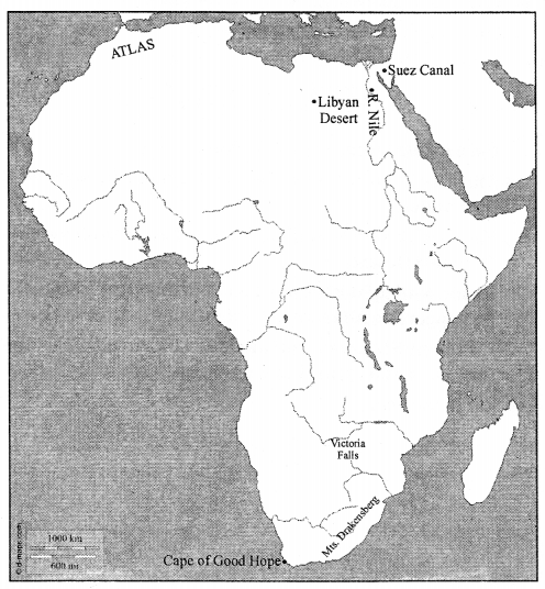
G. Map work:
On a blank outline map of Africa, mark the following:

  1. The Cape of Good Hope
  2. The Drakensberg Mountains
  3. The Victoria Falls
  4. The Atlas Mountains
  5. The Nile River
  6. The Libyan Desert
  7. The Suez Canal

Answer:

ICSE Solutions for Class 7 Geography Voyage Chapter 14 Africa Location, Area, Political & Physical Features 3

H. Picture Study

ICSE Solutions for Class 7 Geography Voyage Chapter 14 Africa Location, Area, Political & Physical Features 4
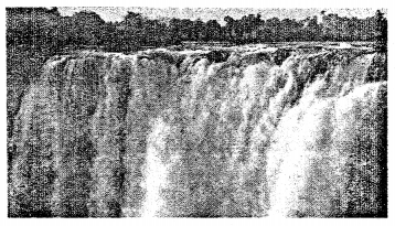
This is a photograph of Victoria Falls.
Question 1.
Name the explorer who discovered it.
Answer:
David Livingstone discovered Victoria Falls in 1855.

Question 2.
On which river is this fall located ?
Answer:
Victoria Fall is located on Zambezi River.

LET’S DO SOMETHING

On a blank outline map of Africa

(a) Mark with brown lines the Atlas and the Drakensberg Mountains.
(b) Shade with yellow and label the Sahara Desert and the Kalahari Desert.
(c) Shade with light brown the plateau region of Africa, the Ethiopian and Adamawa Highlands.
(d) Colour with blue and label neatly all the surrounding water bodies, oceans, seas, bays, gulfs, and straits.

Answer:
Do it Yourself.

ICSE Solutions for Class 7 Geography Voyage – Study of Weather

ICSE Solutions for Class 7 Geography Voyage – Study of Weather

ICSE SolutionsSelina ICSE SolutionsML Aggarwal Solutions

APlusTopper.com provides step by step solutions for ICSE Solutions for Class 7 Geography Voyage. You can download the Voyage Geography ICSE Solutions for Class 7 with Free PDF download option. Geography Voyage for Class 7 ICSE Solutions all questions are solved and explained by expert teachers as per ICSE board guidelines.

ICSE Solutions Class 7 Geography History & CivicsMathsPhysicsChemistryBiology

VALUES AND LIFE SKILLS

Many people leave their pets in parked cars. They think they will be gone for a few minutes, or it will be alright to leave a window open. The temperature inside a parked car can rise up to more than 50°C in a matter of few minutes, irrespective of it being a hot or a cloudy day.
What would be the right thing to do if you see a pet locked inside a car on a hot day ?
Answer:
Leaving pets locked in cars is never safe. But when the weather gets warmer, it can be deadly. High temperatures can cause irreparable organ damage and even death. Protecting animals from an unnecessary death is a problem we can all agree to prevent.

EXERCISES

A. Write true or false. Correct the false statements.

1. A rise in temperature causes more condensation while a fall in temperature results in evaporation.
Answer. False.
Correct : Arise in temperature causes more evaporation while a fall in temperature results in condensation.

2. ‘4 o’clock showers’ are caused by cyclonic rainfall.
Answer. False.
Correct : ‘4 o’clock showers’ are caused by convection currents.

3. Heavy rainfall occurs on the leeward or rain shadow side of a highland.
Answer. False.
Correct : Little rainfall occurs on the leeward or rain shadow side of a highland.

4. The direction of wind blowing on the surface of the earth is affected by the Coriolis force.
Answer. True.

5. Cyclones and anticyclones are examples of variable winds.
Answer. True.

B. Fill in the blanks.

1. The temperature of a place depends upon its latitude, altitude, distance from the sea, ocean currents, winds, cloud cover and slope and aspect.
2. Pressure difference causes horizontal movement of air called wind and vertical movement of air called current.
3. Humidity refers to the amount of moisture or water vapour present in the air.
4. Planetary winds are also called permanent or prevailing winds.
5. The amount of cloud cover in the sky is expressed in discs (shaded in different proportions).

C. Answer the following questions in brief.

Question 1.
What are the elements that determine weather and climate?
Answer:
The elements that determine climate are the same as those weather, namely temperature, atmospheric pressure, humidity, precipitation, wind direction and speed, cloud cover, and sunshine.

Question 2.
Name the factors that determine the temperature at a place.
Answer:
The factors that affect the temperature of a place are latitude, altitude, distance from the sea, ocean currents, winds, cloud cover, and slope and aspect.

Question 3.
How do the following elements influence the weather of a place :

  1. temperature
  2. pressure?

Answer:

  1. Temperature : When the temperature of a place increases, the air gets heated, expands and rises. This leads to a decrease in air pressure in the area. When the temperature falls, the air gets cold, contracts, and descends downwards. This leads to an increase in air pressure. Thus, air pressure decreases with an increase in temperature. This is the reason why areas close to the equator generally have low air pressure.
  2. Pressure : Atmospheric pressure is the pressure that the atmopshere exerts on the surface of the earth because of its weight. There is a close relationship between pressure and temperature — high temperature means low pressure and vice versa. Pressure difference causes horizontal movement of air called wind and vertical movement of air called current, which together cause circulation of air in the atmosphere.

Question 4.
Name the various forms of precipitation.
Answer:
Rain, drizzle, snow, sleet, and hail are all different forms of precipitation.

Question 5.
How is cloud cover shown on a weather map? Give examples.
Answer:
The cloud cover in the sky is expressed in eighths of the total sky or oktas, which are shown in weather maps as discs shaded in different proportions.

D. Answer the following questions in one or two paragraph’s.

Question 1.
How is weather different from climate?
Answer:
Weather and climate are closely related terms but have different
meanings. Weather refers to the atmospheric conditions of a small area for a short period of time, usually 24 hours or one day, while climate is the average of the atmospheric conditions of a larger area, over a long period of time, usually 35 years.

Question 2.
What is condensation? Explain these different forms of condensation: fog, mist, and dew.
Answer:
Condensation is the process by which water vapour in the air gets converted into tiny droplets of water or ice. It is the opposite of evaporation. Evaporation takes place when air is dry, but condensation occurs only after air is saturated.
Fog and mist are formed at night, when air cools below its dew point near the earth’s surface. Fog is denser than mist and often dangerous because it reduces visibility. Dew forms in winter when the temperature is very low, but not below 0°C.

Question 3.
What do you understand by the term ‘4 o’clock showers’?
Answer:
In regions closer to the equator, the rate of evaporation is very high. Air gets heated because of the high temperature and starts rising in the form of convection currents. As it rises, it expands and cools. The cooling causes condensation, which results in heavy downpours. This rain is accompanied by thunder and lightning and since it mostly occurs around 4 p.m., it is often called the 4 o’ clock showers’.

Question 4.
What are planetary winds? Give a brief description of the Westerlies in the northern hemisphere.
Answer:
Planetary winds are also called permanent or prevailing winds as they blow the year round in the same areas. Westerlies blow in the middle latitudes between 30° and 60° latitude, and originate from the high pressure area in the horse latitudes towards the poles. Under the effect of the coriolis force, they become the South Westerlies in the north hemisphere and Northern Westerlies in the southern hemisphere.

Question 5.
What are local winds? Give a few examples.
Answer:
Local Winds blow for a short period of time over a very small area. Some local winds like Loo, Simoom, Chinook, and are warm winds. Others such as the Bora, Mistral, Buran, and Pampero are cold winds.

E. With the help of your atlas,encylopaedias, and the Internet, find out about the climate of these places.

  1. Mumbai
  2. Delhi
  3. Kolkata
  4. London
  5. New York
  6. Sydney

F. In your notebook, draw neat, labelled, coloured sketches of the three different types of rainfall. Alongside each diagram, briefly describe in your own words, how each type of rainfall occurs.
Answer:

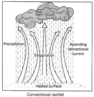
(a) Convectional Rainfall : In regions closer to the equator, the rate of evaporation is very high. Air gets heated because of the high temperature and starts rising in the form of convection currents. As it rises, it expands and cools. The cooling causes condensation, which results in heavy downpours. This rain is accompanied by thunder and lightning and since it mostly occurs around 4 p.m., it is often called the 4 o’clock showers’.
ICSE Solutions for Class 7 Geography Voyage Chapter 5 Study of Weather 1
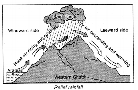
(b) Relief or Orographic Rainfall : Sometimes moisture-bearing winds are forced to rise because of the presence of a physical
ICSE Solutions for Class 7 Geography Voyage Chapter 5 Study of Weather 2
ICSE Solutions for Class 7 Geography Voyage Chapter 5 Study of Weather 3

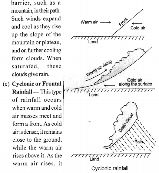
expands and cools, and the moisture in it condenses to form clouds. These clouds bring rainfall.

G. Picture study

Question 1.
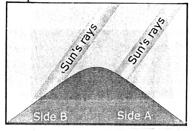
The diagram alongside illustrates one of the factors that affect temperature. What is it ?
ICSE Solutions for Class 7 Geography Voyage Chapter 5 Study of Weather 4
Answer:
Aspect refers to the direction of a slope with respect to the sun’s rays. In the northern hemisphere, all the south-facing slope receive the direct rays of the sun and are, therefore, warmer, while the north-facing slopes are cooler. In the southern hemisphere, all the north-facing slopes receive more sunlight than the south-facing slopes.

Question 2.
Which side of the mountain is likely to have houses and be covered with trees ?
Answer:
Side B.

ICSE Solutions for Class 7 Geography Voyage – Africa: Climate, Natural Vegetation, Wildlife; Minerals

ICSE Solutions for Class 7 Geography Voyage – Africa: Climate, Natural Vegetation, Wildlife; Minerals

ICSE SolutionsSelina ICSE SolutionsML Aggarwal Solutions

APlusTopper.com provides step by step solutions for ICSE Solutions for Class 7 Geography Voyage. You can download the Voyage Geography ICSE Solutions for Class 7 with Free PDF download option. Geography Voyage for Class 7 ICSE Solutions all questions are solved and explained by expert teachers as per ICSE board guidelines.

ICSE Solutions Class 7 Geography History & CivicsMathsPhysicsChemistryBiology

THINK AND ANSWER

The northern and southern parts of Africa have opposite seasons at any time of the year. Why ?
Answer:
A large part of Africa lies between the tropics, and, therefore, most of the continent has a warm or hot climate. However, the amount of rainfall and humidity varies from area to area.
Anoteworthy feature ofthe climate of Africa is that the northern and southern parts of the continent have opposite climates at any time ofthe year. In other words, when the northern part experiences summer, the southern part experiences winter.

Discuss

Discuss how the location of Africa has affected the climate ofthe country.
Answer:
Since most of Africa lies within the tropics, the temperatures are high throughout the year. The variations between summer and winter temperatures are only slight.

VALUES AND LIFE SKILLS

Africa rainforests are one of the densest forests on earth. A large number of trees grow in a relatively small area because the region receives a lot of rain and sunshine, both importance for the growth of plants. Human being also fourish when they get the right conditions.
Can you enlist a few factors that affect the growth of human beings ?
What factors adversely affect the growth of people in an area ?
Answer:
The factors that affect the growth of human beings are :

  1. Proper balanced and nutrionational diet.
  2. Proper health and sanitary facilities.
  3. Proper temperature.

The factors that adversely affect the growth of people in an area are :

  1. Poor or unhealthy diet.
  2. Poor sanitation
  3. Poor water facilities
  4. Lack of awareness.

EXERCISES

A. Write True or False. Correct the false statements.

1. Nights are very hot in the Sahara Desert.
Answer. False.
Nights are very cold in the Sahara Desert.

2. The cold Canaries Current washes the north-west coast of Africa ?
Answer. True.

3. Savannah is another name for the Sudan type of climate.
Answer. True.

4. Temperate grasslands have dry, tall grasses.
Answer. False.
Temperate grasslands have green, short grasses.

5. The Kalahari Desert is located in north Africa.
Answer. False.
The Kalahari Desert is located in south-central Africa.

B. Give geographical reasons.

Question 1.
The equatorial region has dense forests.
Answer:
The equatorial region has dense forests as trees grow in this region to different heights, giving an impression of a three-tier formation. The topmost layer is the emergent layer. The giant trees thrust above the dense layer of trees and have huge mushroom shaped crowns. The trees in this layer receive a lot of sunlight and rain. The second layer is the canopy layer. The broad irregular crown of these trees form a tight, continuous canopy 20-30 m above the ground. The branches are often densely covered with other plants and tied together with vines.
The third layer is the understorey, which receives very little sunlight and is very dark. It has young trees, shrubs, ferns, creepers, and orchids. The forest floor usually has a layer of decomposed leaves, branches, and fruits that have fallen from the trees above. As there is very little sunlight here, the growth of plants is poor. Thus, these forests are very dense and gloomy.

Question 2.
The grasses of the savannah and the veldt are different.
Answer:
Veldts or temperate grasslands are found in South Africa. The vegetation consists of short grasses, less coarse and green than those in the savannahs. On the hill slopes, poplars and willows are common.

Question 3.
Plants in the Sahara are thorny and dry.
Answer:
Plants in the Sahara are thorny and dry as these plants have thorny leaves, thick waxy stems, and long thin roots which penetrate deep for underground water.

Question 4.
Not much wildlife is found in the Mediterranean region ofAfrica.
Answer:
Not much wildlife is found in the Mediterranean as the forests in the Mediterranean region are not extensive and most of the natural vegetation has been cut down, not much wildlife is found in the this region.

C. Answer the following questions in brief.

Question 1.
Most ofAfrica is hot. Why ?
Answer:
A large part of Africa lies between the tropics, and, therefore, most of the continent has a warm or hot climate. However, the amount of rainfall and humidity varies from area to area.

Question 2.
What factors influence the climate of Africa ?
Answer:
The factors that affects the climate of Africa are latitudinal extent, land and sea contrast, ocean currents, and altitude.

Question 3.
Name a cold and a warm current that affect the climate of Africa.
Answer:
The cold Canaries Current washes the north-west coast of Africa, while the cold Benguela Current washes the shores of south-west Africa and has a cooling influence on the adjacent land. Winds blowing over these cold currents become cold and do not pick up moisture.

Question 4.
What are 4 o’clock showers ? In which climatic region of Africa do they occur ?
Answer:
This type of climate is found in the lowlands on either side of the equator in the Congo Basin, the coastal region around the Gulf of Guinea and coastal Kenya. The climate is characterized by a high temperature of 27°C throughout the year and heavy annual rainfall of200-250 cm. Thus, there is high humidity all through the year and there are no clearly marked seasons. There is a daily occurrence of convectional rainfall. This type of rainfall is the result of intense heating of the land surface. During the day, there is a lot of evaporation. By afternoon, when it starts cooling, the water vapour condenses and falls as rain. Since it pours around 4 o’clock every day, it is known as ‘4 o’clock showers’.

Question 5.
Which region is called an open air zoo ? Why ?
Answer:
Savannah or Tropical sub-humid type of region is often referred to as an open air zoo.
The savannah has vast grassy plains with tall, coarse grasses. Many herbivorous animals such as giraffes, elephants, and zebras and carnivorous animals such as lions, cheetahs, and leopards are found here in large numbers and, therefore, this region is referred to as an open air zoo.

D. Answer the following questions in one or two paragraphs.

Question 1.
Describe the three-tier forest of the equatorial region.
Answer:
The equatorial region has dense forests. Trees grow in this region to different heights, giving an impression of a three-tier formation. The topmost layer is the emergent layer. The giant trees thrust above the dense layer of trees and have huge mushroom shaped crowns. The trees in this layer receive a lot of sunlight and rain. The second layer is the canopy layer. The broad irregular crown of these trees form a tight, continuous canppy 20-30 m above the ground. The branches are often densely covered with other plants and tied together with vines.
The third layer is the understorey, which receives very little sunlight and is very dark. It has young trees, shrubs, ferns, creepers, and orchids. The forest floor usually has a layer of decomposed leaves, branches, and fruits that have fallen from the trees above. As there is very little sunlight here, the growth of plants is poor. Thus, these forests are very dense and gloomy. The hardwood trees are valuable for making good quality furniture as the wood is heavy, but the trees are difficult to exploit as they do not grow in pure stand.

Question 2.
Give examples of herbivorous and carnivorous animals found in the savannah grasslands.
Answer:
Herbivorous animals such as the elephant, deer, giraffe, and zebra and carnivorous animals such as the lion, cheetah, and leopard are found in large numbers.

Question 3.
Identify the hot deserts of Africa and briefly describe the climatic conditions in terms of temperature and rainfall.
Answer:
Summers are hot and winters are cool in the hot desert regions. The daily as well as annual range of temperature is large-due
to the absence of cloud cover and the sandy nature of the soil. There is hardly any rainfall. These climatic conditions are found both in the northern and the southern hemispheres. In north Africa it is mainly experienced in the Sahara Desert and in south-central Africa in the Kalahari Desert.

Question 4.
Why is the camel called ‘the ship of the desert’ ?
Answer:
The camel is called ‘the ship of the desert’ for the following reasons:

  1. It carries goods and people across the vast sandy deserts.
  2. It stores fat in its hump.
  3. Its padded feet prevent it from sinking in the sea of sand.
  4. It has double eyelids and long eyelashes to protect its eyes from sand during storms.
  5. It can close its nostrils during sandstorms.

Question 5.
Describe the Mediterranean climate.
Answer:
The coastal areas of north-west Africa and a small area in the south-west of South Africa experience the Mediterranean climate. Summers are hot with plentiful sunshine but no rainfall. Winters are mild and wet. Shifting Westerlies bring rain to these regions in their respective winter seasons.

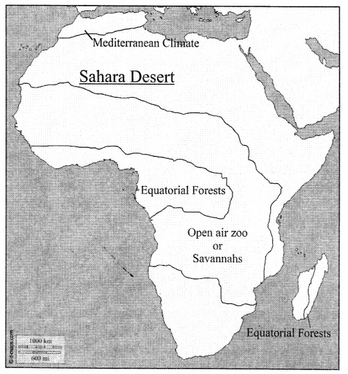
E. In the outline map of Africa give here, mark the features and answer the questions.

Question 1.
Colour dark green the area where equatorial forests are found. What difficulties were faced by the explorers because of rivers and natural vegetation of the region ?
Answer:
The equator passes through the middle of the continent and most of Africa lies within the tropics. It is, therefore, the hottest continent.
People faced many difficulties while exploring Africa. In the north, the Sahara, the world’s largest desert, was impenetrable due to severe heat and dry conditions. Most of Africa consists of undulating plateaus, so it was difficult to reach the interior from the coastal areas. The rivers of Africa have many rapids and waterfalls, and are not fit for navigation. The extensive equatorial forests and swampy lands teeming with dangerous tsetse flies and poisonous insects discouraged explorers from entering the heart of the continent.

ICSE Solutions for Class 7 Geography Voyage Chapter 15 Africa Climate, Natural Vegetation, Wildlife Minerals 1

Question 2.
Mark the area that is called an ‘open air zoo’. Name thevegetation of this region.
Answer:
These vast grassy plains with tall, coarse grasses are called the savannahs or tropical grasslands. Several varieties of grass, including elephant grass, grow here. Some acacia and baobab trees are found interspersed between the grasses. Please check Map given on Textbook page 126 (Africa : Climatic and vegetation regions)

Question 3.
Mark the Sahara Desert. Name a plant that best survives in the climate of this region. What are the characteristic features of this plant that help it survive ?
Answer:
The trees have long roots, small waxy leaves, and thick spongy bark, which help them survive in the dry summers. Examples include cork, oak, laurel, olive, and fig. Forests are not extensive as most of them have been cut down and replaced by orchards of citrus fruit trees such as oranges, lemons, and grapes.

Question 4.
Mark the area north of the Atlas Mountains where the Mediterranean climate is found. Which crops does this climate support ?
Answer:
The trees have long roots, small waxy leaves, and thick spongy bark, which help them survive in the dry summers. Examples include cork, oak, laurel, olive, and fig. Forests are not extensive as most of them have been cut down and replaced by orchards of citrus fruit trees such as oranges, lemons, and grapes.

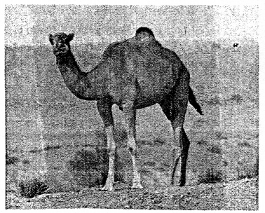
F. Picture study

ICSE Solutions for Class 7 Geography Voyage Chapter 15 Africa Climate, Natural Vegetation, Wildlife Minerals 2

Question 1.
What kind of climate is experienced in the region shown in the picture ?
Answer:
Summers are hot and winters are cool in the hot desert regions. The daily as well as annual range of temperature is large due to the absence of cloud cover and the sandy nature of the soil. There is hardly any rainfall. These climatic conditions are found both in the northern and the southern hemispheres. In north Africa it is mainly experienced in the Sahara Desert and in south-central Africa in the Kalahari Desert.

Question 2.
What kind of vegetation grows in such a climate ?
Answer:
The trees have long roots, small waxy leaves, and thick spongy bark, which help them survive in the dry summers. Examples include cork, oak, laurel, olive, and fig. Forests are not extensive as most of them have been cut down and replaced by orchards of citrus fruit trees such as oranges, lemons, and grapes.

Question 3.
Fill in the blanks : The animal seen in the picture is often referred to as the _____ of the _____
Answer:
Fill in the blanks: The animal seen in the picture is often referred to as the ship of the desert.