ICSE Solutions for Class 7 Geography Voyage – Weathering and Soil
ICSE SolutionsSelina ICSE SolutionsML Aggarwal Solutions
APlusTopper.com provides step by step solutions for ICSE Solutions for Class 7 Geography Voyage. You can download the Voyage Geography ICSE Solutions for Class 7 with Free PDF download option. Geography Voyage for Class 7 ICSE Solutions all questions are solved and explained by expert teachers as per ICSE board guidelines.
ICSE Solutions Class 7 Geography History & CivicsMathsPhysicsChemistryBiology
Discuss
From encycopaedias and the Internet, find out the different types of soil found in India. Discuss the importance of these soils for crops cultivated in our country. You should form groups in class for this activity.
Answer:
Soils of India: Six Different Types of Soils Found in India are as follows:
Soil is our prime natural and economic resource. Soils in India differ in composition and structure.
- Alluvial Soils : These are formed by the deposition of sediments by rivers. They are rich in humus and very fertile. They are found in Great Northern plain, lower valleys of Narmada and Tapti and Northern Gujarat. These soils are renewed every year.
- Black Soils : These soils are made up of volcanic rocks and lava-flow. It is concentrated over Deccan Lava Tract which includes parts of Maharashtra, Chhattisgarh, Madhya Pradesh, Gujarat, Andhra Pradesh and Tamil Nadu. It consists of Lime, Iron, Magnesium and also Potash but lacks in Phosphorus, Nitrogen and Organic matter.
- Red Soils : These are derived from weathering of ancient metamorphic rocks of Deccan Plateau. Its redness is due to iron composition. When iron content is lower it is yellow or brown. They cover almost the whole of Tamil Nadu, Andhra Pradesh, Chhattisgarh, Karnataka, Maharashtra and parts of Orissa.
- Laterite Soils : These soils are formed due to in-tense leaching and are well developed on the sum-mits of hills and uplands.
They are commonly found in Kerala, Tamil Nadu, Maharashtra, Chhattisgarh and hilly areas of Orissa and Assam. - Mountain Soils : These soils are formed as a result of the accumulation of organic matter derived from forest growth. They are found in Himalayan region and vary in different regions according to altitude. Tea is grown in those areas which receive sufficient rainfall.
- Desert Soils : In the desert regions of Rajasthan, soils are not well developed. As evaporation is in excess of rainfall, the soil has a high salt content and saline layer forms a hard crust. These soils are gen-erally sandy and deficient in organic matter.
THINK AND ANSWER
Soil formation is an important benefit of weathering. How is it important for mankind ?
Answer:
Soil formation is an important for mankindas :
- A habitat for several plants and animals
- A storage bank for water and nutrients
- Foundation of the world’s food chain
- Provides an anchor for plants
VALUES AND LIFE SKILLS
People have used various farming methods to increase food production. However, in the process, they have stripped soil of nutrients, leading to its degradation.
Can you suggest some ways by which we can reduce soil degradation ?
Answer:
We can reduce soil degradation by Contour tilling, terrace farming, strip cropping, contour bunding, afforestation, crop rotation, fallowing and controlled grazing.
EXERCISES
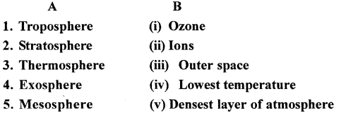
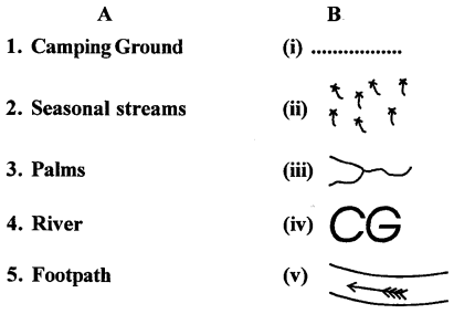
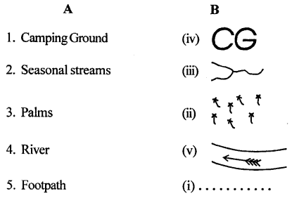
A. Match the column
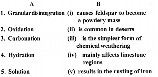
Answer:
B. Distinguish between each of the following pairs
Question 1.
Degradation and aggradation
Answer:
Degradation :
The process by which rock materials from the earth’s surface are removed resulting in general lowering of land surfaces.
Aggradation :
The process by which the rock material removed from the earth’s surface and then deposited in depressions such as valleys, lakes and sea beds. The depression fills
Question 2.
Weathering and erosion
Answer:
Weathering :
It is the process by which rocks on the land surface break down or crumble because of the action of the elements of weather such as rain, frost and temperature changes.
Erosion :
It is the process by which the weathered materials are transported elsewhere by agents such as running water, moving ice waves, and winds.
Question 3.
Granular disintegration and exfoliation
Answer:
Granular disintegration :
A form of weathering where the grains of a rock become loosened and fall out to leave a pitted and uneven surface.
Exfoliation :
When the surface layers of rounded and boulders gradually peel off in layers due to expansion of the outer layer during the day and the contraction of the same layer during night, the process is called exfoliation.
Question 4.
Hydration and solution
Answer:
Hydration :
This occurs when water itself chemically combines with some minerals present in rocks. Thus, crystalline minerals, such as feldspar and potash, absorb water and become a powdery mass due to the process of hydration, resulting in their erosion.
Solution :
This is the simplest form of chemical weathering by which some minerals dissolve in water when rainwater falls on rocks or when river water flows over rocks. The soluble minerals dissolve and are removed, . resulting in the breakup of the rocks.
Question 5.
Soil erosion and soil conservation
Answer:
Soil erosion :
It refers to the washing away or removal of the layers of soil by various agents like running water and wind.
Soil conservation :
It refers to the protection of soil against erosion and exhaustion because of deforestation, excessive grazing, running
C. Give geographical reasons
Question 1.
Temperature changes result in physical weathering.
Answer:
Temperature changes result in expansion and contraction of rocks during day and night resulting in degradation of rocks. In the temperate latitudes the frost shatters the rocks.
Question 2.
Gases in the atmosphere affect weathering.
Answer:
The minerals contained in the rocks react with the gases and moisture in the air like oxygen reacts with iron and causes the rocks to rust and get eroded.
Question 3.
Human activities affect weathering.
Answer:
Human activities like mining, quarrying deforestation, tunnelling, road construction and farming affect the weathering.
Question 4.
Soil is a very important resource.
Answer:
Soil is an important resource as human beings depend on it for their basic needs of food, shelter and clothing. It takes thousands of years for a thin layer of soil to form.
Question 5.
There is a need for soil conservation.
Answer:
Soil should be conserved as humans depend directly or indirectly on soil for their basic needs of food, shelter and clothing.
D. Answer the following questions in brief
Question 1.
Name any four agents of erosion.
Answer:
Soil erosion also refers to the loss of fertility of soil, which makes the soil infertile and exhausted. Cutting down of trees and forests, overgrazing by animals, floods, and improper farming practices are some of the main causes of soil erosion.
Question 2.
List any three factors that affect weathering.
Answer:
Factors that affect weathering are :
- Local climate
- Mineral composition
- Structure of rock
- Human activities
- Amount of exposed or bare rocks surface, and human activities.
Question 3.
In which regions of the world is ‘frost action’ the common form of weathering?
Answer:
In temperate latitudes frost action is common form of weathering.
Question 4.
Which is the most important effect of weathering?
Answer:
Landslides and soil erosion are two major effects of weathering.
Question 5.
What are the components of topsoil?
Answer:
The topmost layer is the topsoil (Layer D) which consists of clay, silt, sand and humus.
Question 6.
Name the various methods of conserving soil.
Answer:
The various methods of conserving soil are :
Contour tilling, terrace farming, strip cropping, contour bunding, afforestation, crop rotation, fallowing and controlled grazing.
Question 7.
Distinguish between contour tilling and contour bunding.
Answer:
Contour Tilling — In this method the farmer tills or ploughs
the fields along the contours of the land rather than tilling up and down the slope. Contour tilling is practised in hilly areas rather than the plains. It prevents the soil from being washed away by water or by surface run-off as the contour acts like a bund. The contour also facilitates the percolation of water into the soil.
Contour Bunding — Soil is conserved by making bunds or walls or embankments made of mud along contour lines to prevent water from draining out of the cultivated field, thereby preventing erosion.
Question 8.
What do you understand by controlled grazing ?
Answer:
Controlled grazing is a simple method of soil conservation, It is to restrict the grazing of cattle, sheep and goats on grasslands and within forests. When cattle graze on fields, grass and smaller plants get tom from their roots, leaving the soil loose and exposed to wind and water erosion. Moreover, the pressure of the animals hooves on the soil makes it lose its cohesion and structure, exposing it to the forces of wind and water. Land meant for grazing of cattle should be specially selected and fenced off.
E. Answer the following questions in one or two paragraphs
Question 1.
What is gradation? Describe the two processes involved in gradation.
Answer:
Gradation is the process of levelling the land by means of moving agents like rivers, or wearing away and lowlands are raised by adding the eroded material by the process of deposition. This is because there is constant earth movement which raises mountains and winds, seas and waves. The highlands are made low by erosion and this process is called degradation and materials are deposited elsewhere in depressions like valleys, lakes, etc. and these lowlands are raised by the process called aggradation.
Question 2.
Describe the process that leads to exfoliation.
Answer:
When the surface layers of rounded rocks and boulders gradually peel off in layers is called exfoliation. This occurs due to expansion of the outer layer during the day and the contraction of the same layer during the night, repeatedly over a period of time.
Question 3.
Discuss the role of water in the process of chemical weathering.
Answer:
Water plays an important role in chemical weathering. The carbon dioxide in atmosphere dissolves in rainwater and form carbonic acid and reacts with minerals in the rocks. The soluble minerals dissolve in water such as feedspar and potash absorb water and become a powdery mass. Similarily soluble minerals dissolve and are removed, resulting in the breakup of the rocks. Rock salt, gypsum, and silica are examples of minerals that are highly soluble and when rainfall falls they decompose.
Question 4.
How do animals and plants assist in weathering?
Answer:
The decaying remains of dead plants in soil tend to form organic acid which when dissolved in water cause chemical weathering. Ants, earthworms and burrowing animals such as rats and rabbits loosen soil and make tunnels causing weathering.
Question 5.
What is meant by the terms ‘soil erosion’ and ‘soil conservation’?
Answer:
Soil erosion refers to washing away or removal of the layer of soil by various agents like running water and wind.
Sheet erosion and gully erosion are the two most common ways by which soil gets eroded. When there is heavy rainfall, the top layer of soil over large areas gets washed away. This is known as sheet erosion. When rainwater in region flows down the slopes making deep and narrow furrows, it is called gully erosion. Soil erosion also refers to the loss of fertility of soil, which makes the soil infertile and exhausted.
Cutting down the trees and forests, overgrazing by animals, floods, and improper farming practices are some of the main causes of soil erosion.
Soil conservation is the protecting of soil against erosion and exhaustion by planting trees, shrubs and grass on hill slopes.
Soil can be conserved by controlling grazing of cattle and use of proper farming methods such as the levelling of fields, terracing of hill slopes, construction of mud walls or bunds and ploughing fields in circles.
Question 6.
Why is soil conservation important ? Give three reasons.
Answer:
Soil conservation is very important because soil consists of
mineral particles, moisture, living organisms like bacteria and earthworms, and decayed organic matter. It is one of the most important resources as human beings-depend on it, both directly and indirectly, for their basic needs of food, shelter, and clothing. It takes thousands of years for even a thin layer of soil to form.
Question 7.
Explain any two methods of soil conservation briefly.
Answer:
- Contour Tilling — In this method the farmer tills or ploughs
the fields along the contours of the land rather than tilling up and down the slope. Contour tilling is practised in hilly areas rather than the plains. It prevents the soil from being washed away by water or by surface run-off as the contour acts like a bund. The contour also facilitates the percolation of water into the soil. - Terrace Farming — Terrace farming involves making terraces or steps on a hill or mountain by cutting into the side of the hill or mountain. Since the land is made flat, it reduces surface run-off, thereby preventing erosion. It also facilitates the absorption of water into the soil. Terrace cultivation is common on mountain slopes all over the world.
- Contour Bunding — Soil is conserved by making bunds or walls or embankments made of mud along contour lines to prevent water from draining out of the cultivated field, thereby preventing erosion.
F. Make a chart for your classroom showing the causes of different types of weathering.
Answer:
Do it yourself.
G. Form pairs or groups of three or four students and discuss, with examples, how we depend directly and indirectly on soil.
Answer:
Do it Yourself with the help of teacher.
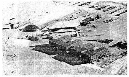
H. Picture Study
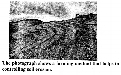
Question 1.
What is this farming method called ?
Answer:
Terrace farming.
Question 2.
Mention any two other methods that help in controlling soil erosion.
Answer:
Construction of mud walls, ploughing fields in circles, levelling of fields can also prevent soil erosion.