ISC Geography Previous Year Question Paper 2013 Solved for Class 12
PART-I (30 Marks)
Answer all questions
Question 1. [20]
(i) Although the time of sunrise varies between Arunachal Pradesh and New Delhi, the watches show the same time. Explain why.
(ii) Compare the land area of India with that of China.
(iii) In the diagram given below, A represents the path of an upper atmospheric air movement in the cold weather season.
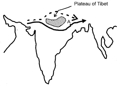
(a) Name A
(b) Explain how A influences the weather of India during winter season.
(iv) State any two ways in which Himalayas affect the Indian climate.
(v) Name the two streams which unite at Devaprayag to form into river Ganga.
(vi) Mention the Period of Stagnant Population and Period of Population Explosion in India.
(vii) State any one use of aluminium. Name a centre for aluminium industry in India.
(viii) What is a port ? What advantage does the Mumbai port have over the other ports of India in international trade?
(ix) Distinguish between a major industrial region and a minor industrial region.
(x) Define the term micro-region. Name any one micro-region in India.
Answer:
(i) The time of sunrise varies between Arunachal Pradesh and New Delhi by 72 minutes because it lies to the east with a difference of about 18° of longitude but the watches show the same time because all places in India follow the same time that is recorded in Allahabad (82.5 °E) which is the Indian Standard Time. This is done to avoid confusion in time in the entire country.
(ii) China has a total land area of 95.97 lakh sq.km. India has a total land area of 32.87 lakh sq. km. Thus, China is three times larger than India in terms of land area.
(iii) (a) A is the Westerly Jet stream.
(b) During the winter season in India, this jet stream has a great influence on the weather of India as it attracts the western disturbances, which originate in Mediterranean Sea and give a light rain in winter. Hail storm in the north-western plains and occasional heavy snowfall in the hilly regions also takes place.
(iv) The two ways in which Himalayas affect the Indian climate are :
- It acts as a barrier to the cold winds of Northern Asia from blowing into India and protecting India from severely cold winters.
- It traps the monsoon winds forcing them to shed their moisture within the subcontinent.
(v) The two streams that unite at Devaprayag to form into the river Ganga are Alaknanda and Bhagirathi.
(vi) Period of stagnant population —1901-1921 Period of population explosion —1951-1981.
(vii) Aluminium is used in making aeroplanes and ships. Renukoot in Uttar Pradesh is a centre for aluminium industry in India.
(viii) A port is that place on the coast or shore, with docks, wharves and berthing facilities, where cargo in large quantities is received from oceanic routes and sent to the interior of the country through land routes and vice versa.
Mumbai port is the biggest port of India and handles approximately one-fifth of India’s foreign trade with pre-dominance in dry cargo and mineral oil from the Gulf countries. It handles foreign trade with the Western countries and East African countries. It’s biggest advantage over other ports of India, in international trade is that it is closest to the Gulf countries, East Africa and Europe.
(ix)
| Major Industrial Region | Minor Industrial Region |
| 1. It is the region with a minimum daily factory working force of 1-5 lakh. | It is the region with a minimum daily factory working force of 25,000. |
| 2. For example – Gujrat Industrial Region, Mumbai-Pune Industrial Region. | For example – Jaipur-Ajmer Industrial Region. |
(x) A micro-region is defined as a territorial area smaller than the state to which it belongs but larger than a municipality and also has the potential for developing at least one specialisation of production of cycle. Agriculture in Punjab and the Hilly region in U.P. is an example of a micro-region.
Question 2. [10]
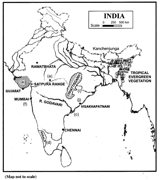
On the outline map of India provided :
(a) Mark and name a mountain range situated between the two west flowing rivers of Peninsular India.
(b) Mark and name the highest peak of the Himalayan range in India.
(c) Trace the course and name the river which has the largest extent in Peninsular India.
(d) Mark and name the state which has the highest literacy rate according to census 2001.
(e) Mark and name the main groundnut producing state in India.
(f) Trace the shortest arm of the Golden Quadrilateral. Name any one of its terminal towns.
(g) Mark and name the Nuclear Power Station located to the north of Tropic of Cancer.
(h) Shade an area of tropical evergreen vegetation in Northeast India.
(i) Shade the region of Chhattisgarh.
(J) Mark the port city ofVisakhapatnam.
Answer:
PART-II (40 Marks)
Answer any four questions.
Question 3.
(a) (i) State the location and extent of Bhabar. Mention any two differences between Bhabar and Tarai. [3]
(ii) Name the country with which India shares the longest land boundary. Mention the length of the boundary in kilometres.
(b) (i) Give two reasons as to why Western Rajasthan is a desert. [3]
(ii) Name any two Himalayan drainage systems of India.
(c) Briefly explain the geological formation of the Peninsular Plateau. [2]
(d) State the climatic conditions of the tropical evergreen forests in India. [2]
Answer:
(a) (i) Bhabar is a plain situated along the foot of the Shiwaliks from the Indus to the Tista.
| Bhabar | Tarai |
| It lies along the foot of the Shiwaliks from Indus to Tista, about 8 to 16 kms. wide. | It lies to. the south of the Bhabar and runs parallel to it, about 20 to 30 kms. wide. |
| It comprises pebble-studded rocks in the shape of porous beds so it is not suited for agriculture. | It is composed of comparatively finer alluvium and is reclaimed for agriculture. |
(ii) India shares the longest land boundary with Bangladesh. Length of the boundary is 4,096 kms.
(b) (i) Western Rajasthan is a desert because it lies ‘ in the rain shadow area of the Aravalli Hills in
the Bay of Bengal branch of the southwest monsoons coming from the east. These winds when strike the Garo Khasi Hills, are diverted west and northwest along the Ganga plain. As these winds advances, imparting rain, they become less humid and are dry when they reach the Indus Basin in the extreme northwest.
(ii) The two Himalayan drainage systems of India are:
1. The Indus drainage system.
2. The Ganga drainage system.
(c) During the Pre-Cambrian era, there was a large depression in which the sediment was deposited and a block of crystal rocks known as the Peninsular Plateau came out and never submerged again. It is made up of crystalline, hard, igneous and metamorphic rocks. Most geologists believe that the Indian Peninsula is a part of the global Gondwanaland which broke away about 250 million years ago and started drifting northwards, striking the Central Asiatic plate raised up to form the high Himalayas out of the Tethys Sea.
(d) The climatic conditions of the tropical evergreen forests in India are :
1. Rainfall-above 200 cms.
2. Temperature – 24°C average, 24°C – 27°C.
3. Humidity 70%.
Question 4.
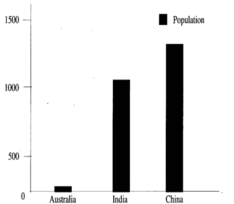
(a) With reference to percentage of world population, compare India’s position with China and Australia. [3]
(b) What are the two main causes for an increase in the number of high population density areas in the Indian region ? [1]
(c) Explain any three reasons for in-migration to the urban city of Lucknow. [3]
(d) With reference to the circular rural settlement pattern, answer the following: [3]
(i) How does this pattern develop ?
(ii) Name any two areas where this pattern is found in India.
Answer:
(a) India is one of the most populous countries of the world. India supports and sustains 16.8 percent of the population of 6,055 million (census of India 2001). India became the second largest country in the world after China to officially cross the one billion mark. Its population is more than about 55 times the population of Australia. India adds every year one Australia to her population. The population of Australia is negligibly small, about 0.3 per cent, compared to the world population.
(b) The two main causes for an increase in the number of high population density areas in the Indian region are :
1. The large scale migration of people from the surrounding areas, in search of livelihood and better amenities of life.
2. People migrate to urban areas because of availability of better educational facilities especially those higher education.
(c) The three reasons for immigration to the urban city of Lucknow are :
- Urban centres like Lucknow provide vast scope for employment in industries, transport, trade and other services.
- It also has a provision for better and higher educational facilities so that there are a number of schools, colleges and university. Hence, the flock of students moves to Lucknow from the neighbouring villages.
- Urban centres also offer hospital facilities, healthcare centres, legal advice and also other services that can be availed.
(d) (i) When the houses are constructed along the banks of a pond, tank or a lake, the settlement takes the shape of a circle. People prefer to build houses near the source of water. In this pattern the houses, offices, business centres, are in the centre. As you move out there are garden plots, surrounded by cultivated land, pastures, woodland, in successive rings.
(ii) The two areas where this pattern is found in India are :
- The upper Ganga-Yamuna Doab region.
- In the parts of Madhya Pradesh, Gujarat and Maharashtra.
Question 5.
(a) (i) Why is there a need for environmental management ? [2]
(ii) What is meant by sustainable development ?
(b) What are the two reasons for the arable land degradation in India ? [2]
(c) Mention three ways in which modern means of irrigation are more advantageous than the ancient methods of irrigation. [3]
(d) (i) Mention two ways in which tube-vsells are better than ordinary wells as a form of irrigation. [3]
(ii) Name any two alternative methods of irrigation.
Answer:
(a) (i) There is a need for environmental management because environmental problems are becoming serious due to increasing population, industrialisation, urbanisation and poor management procedures. In the process of development, the natural resources are used by mankind in thoughtless and indiscriminate manner for their immediate gain. This process results in overall degradation of the environment and increases complexity.
(ii) Sustainable development may be defined as the development that meets the needs of the present without compromising the ability of future generations to meet their own needs.
(b) The two reasons for the degradation of arable land area in India are :
1. Soil erosion.
2. Excessive use of chemical fertilizers.
(c) The modern methods of irrigation are more advantageous than the ancient methods of irrigation because:
1. It is easy to operate.
2. They provide irrigation to a much larger area. e.g. Tube wells use electric motors to pump up water and they can irrigate a much larger area than an ordinary well.
3. Regular irrigation throughout the year e.g. perennial canals.
(d) (i) Tube wells are better form of irrigation than the ordinary wells because :
1. It is capable of irrigating more area, about 2 hectares per day while ordinary wells irrigate 0.2 hectares of area per day.
2. It is operated by an electric motor or by a diesel engine so water can be easily lifted from greater depths and most suitable in those areas where canal irrigation is not available.
(ii) The two alternative methods of irrigation are:
- Sprinkler irrigation.
- Trickle-drip irrigation.
Question 6.
(a) (i) Name any two methods of fishing. [4]
(ii) Mention the leading state for fish production in the Western Coast of India.
State two reasons for the development of the fish industry in India.
(b) What is understood by the term market gardening? State a reason for its development in India. [2]
(c) Compare tea production of India with Sri Lanka. [2]
(d) State any four conditions essential for the generation of hydroelectric power. [2]
Answer:
(a) (i) The two methods of fishing are :
- Drifting
- Trawling
(ii) Kerala is the leading state for fish production in the western coast of India. The fishing industry has developed in India as it has a long, indented coastline dotted with a large number of lagoons and some of the coast remains calm for a long time which is quite convenient for fishing operations.
(b) Market gardening is a section of agriculture in which fruits and vegetables are grown mainly for market purpose. It is relatively a small- scale production and directly sold to consumers and restaurants.
India has developed market gardening as it has a wide variability of climate and soil and produces a large range of horticultural crops like fruits, vegetables, ornamental crops, medicinal crops and aromatic plants.
(c) India is the largest producer of Tea whereas Sri Lanka is the third largest producer. India’s contribution of tea production in the world is about 35% and Sri Lanka accounts for about 12% of the total world production of tea. Sri Lanka is the third largest exporter of tea in the world after India and China.
(d) The four essential conditions for the generation of hydroelectric power are :
- There should be a perennial flow of large volumes of water.
- The water should fall from a sufficient height. It may be in the form of a natural waterfall or a fall obtained by constructing a dam across the river. It may also be obtained by diverting the water from one river basin to another.
- A readily available market is an essential requirement for generating hydro-electric power as electricity cannot be stored.
- It also requires a huge capital investment as it is a capital intensive activity.
Question 7.
(a) (i) What is the importance of transport as an infrastructural resource to industrial economy ? [3]
(ii) Briefly discuss any two natural factors that govern the distribution of roads in India.
(b) Mention any one disadvantage of airways and any one disadvantage of pipelines as a mode of transport. [2]
(c) Name a recently developed port of Tamil Nadu. What is its main purpose? [2]
(d) State three ways in which radio and television are useful means in mass communication. [3]
Answer:
(a) (i) The importance of transport as an infrastructural resource to industrial economy are :
- It is the basic economic arteries and provides an important link between production and consumption. It plays a key role in the origin and growth of industrial economy.
- Transport plays a vital role in production and distribution. Production is facilitated as raw materials are brought to the factory site by quick transport.
- The location of a manufacturing plant, its production and distribution, the growth of cities, towns and ports, domestic and foreign trade all are influenced by transport. Transport and industry are closely related to each other.
- Cheap and efficient transport is essential for localisation and growth of industries. Transportation facilities are required for carrying raw materials and labour force to the manufacturing site and for carrying manufactured goods to the market.
Thus, transport and industries grow side by side in any area.
(ii) The two natural factors that govern the distribution of roads in India are :
- Flat level land.
- High density of population.
(b) One Disadvantage of Airways : It is the costliest mode of transportation and can carry only limited goods and passengers.
One Disadvantage of Pipelines : Underground pipelines cannot be easily repaired and detection of leakage is also difficult. Once it is laid, capacity cannot be increased.
(c) Tuticorin is a recently developed port of Tamil Nadu and handles the traffic of coal, salt, food grains, edible oils, sugar and petroleum products. Its main purpose is to carry on trade with Sri Lanka.
(d) The three ways in which radio and television are a useful means in mass communication are:
- They provide all sorts of useful information, news, and variety of entertain-ment almost reaching to the entire population.
- Radio and television both operate in multiple regional languages in order to cater to the entire population most efficiently and effectively.
- They are the cheapest and widely used medium of communication and the only source of entertainment and information in rural areas and remote places.
Question 8.
(a) On the given sketch map of India :]
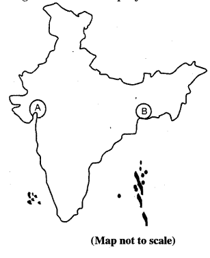
(i) Identify the industrial regions A and B. [3]
(ii) Identify any one factor that has contributed to the growth of :
(1) Region A
(2) Region B
(b) State two ways in which Cotton industry in India is influenced by climate conditions. [2]
(c) Name the leading state for sugar industry in Peninsular India. Name its two centres. Why is there a shift of the sugar industry from North India to Peninsular India ? Give two reasons. [3]
(d) (i) What are petrochemicals ? [2]
(ii) Give one reason for slow growth of international tourism in India.
Answer:
(a) (i) A – Gujarat Industrial Region.
B – Hugli Industrial Region.
(ii) 1. Region A: The Gujarat Industrial Region developed due to the presence of cotton growing tracts in the Gujarat plains. The availability of cheap land, cheap skilled labour and other advantages helped the cotton textile industry. The petrochemical industry has developed due to the availability of oil.
2. Region B: The Hugli Industrial Region has developed as Hugli offered the best site for development of inland river port, and well connected by the Ganga and its tributaries. Besides navigable rivers, roads, and railways provided subsequent links to the great benefit of Kolkata port. Jute industry is the most important industry of this region.
(b) The two ways in which Cotton Industry in India is influenced by climatic conditions are:
1. Cotton yam produced in a humid region is finer and more durable.
2. Cotton threads do not easily break in humid climate.
(c) Maharashtra is the leading state of the sugar industry in Peninsular India. The two centres are Ahmednagar and Kolhapur.
The sugar industry has shifted from North India to peninsular India mainly because :
1. The geographical conditions are more . suitable in the south; the soil is well drained
and free from waterlogging. Southern India is free from frost and has high temperatures ideal for sucrose development.
2, The crushing season is also much longer in the south than in the north. For example—
crushing season is nearly four months in the north from November to February whereas crushing season in south is nearly 7-8 months from October and continues till May and June,
(d) (i) Petrochemicals are those chemicals and compounds which are derived from rresources of petroleum and these chemicals are used for manufacturing a large variety of articles such as synthetic fibres, synthetic rubber, plastics, dye stuffs, drags and pharmaceuticals.
(ii) The slow growth of international tourism in India is mainly because of its under-developed infrastructure of highways, railways ports, civil aviation, telecommunications. Inadequacies of infrastructural facilities adverself affect tourism.
Question 9.
(a) How is multi-level planning different from single level planning. [2]
(b) Explain the following levels of planning in the regional economical development: [2]
(i) Block level planning.
(ii) Panchayat level planning.
(c) With reference to mining in Chhattisgarh, name two minerals each mined from the following centres : [2]
(i) Surguja district.
(ii) Bastar and Durg districts.
(d) What is an economist’s contribution to the development of a region ? [2]
(e) With reference to Haldia Port, state the following :
(i) Its location.
(ii) The two main items of trade.
Answer:
(a)
| Multi-Level Planning | Single Level Planning |
| 1. Multi-level planning is the planning at different levels like village, block, district, state and nation. The multi-level planning may be defineas‘planning for a variety of regions which together form a system and subordinate systems’. | Single level planning is done at the national level in which the planning process is centralised. |
| 2.The country is divided into smaller territorial units, depending upon the size of the country, the administration, the geographical and the cultural setting of different parts of the country. | Lower territorial levels come into picture only at the implementation stage.
|
(b) (i) Block Level Planning : In block level planning, each district is divided into blocks consisting of about 100 villages with a population of about 60,000. This planning was aimed at mobilisation of the local resources and participation of the local people in decision making and implementation of the development scheme. It is initiated under the leadership of a block development officer and a team of various specialists and village level workers.
(ii) Panchayat Level Planning : A Panchayat is an elected body in which villagers, as voters, elect their representatives. The Panchayat Raj system has a three-tier structure, i.e., firstly, the village level is popularly known as Gram Panchayat or Gram Sabha, secondly the block level is Panchayat Samiti and thirdly the district level is called Zila Parishad.
(c) The two minerals mined from the following centres:
- Surguja District: coal and bauxite.
- Bastar and Durg Districts : iron ore and limestone.
(d) The largest contribution to the study of development has been made by economists. An economist looks at development in terms of economic progress, which is expressed in terms of enhancement in general productivity level, per capita income, efficiency of a worker, overall improvement in quality of life in general and elimination of poverty in particular. The economists have met with greater success in the formulation of theories and models and have earned greater acceptability in policy formulation.
(e) (i) Location : It is located at the confluence of rivers Hugli and Haldia about 105 km downstream from Kolkata.
(ii) Items of Trade : The main items of trade are mineral oil and petroleum products.